Related Research Articles

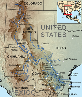
The Rio Grande, known in Mexico as the Río Bravo del Norte or simply the Río Bravo, is one of the principal rivers in the southwestern United States and in northern Mexico. The length of the Rio Grande is 1,896 miles (3,051 km). It originates in south-central Colorado, in the United States, and flows to the Gulf of Mexico. The Rio Grande drainage basin (watershed) has an area of 182,200 square miles (472,000 km2); however, the endorheic basins that are adjacent to and within the greater drainage basin of the Rio Grande increase the total drainage-basin area to 336,000 square miles (870,000 km2).
Lipan Apache are Southern Athabaskan (Apachean) Native Americans whose traditional territory includes present-day US states of Texas, New Mexico, and Colorado, and the northern Mexican states of Chihuahua, Nuevo León, Coahuila, and Tamaulipas, prior to the 17th century.

The Conejos River is a tributary of the Rio Grande, approximately 92.5 miles (148.9 km) long, in south-central Colorado in the United States. It drains a scenic area of the eastern San Juan Mountains west of the San Luis Valley.

Grindelia (gumweed) is a genus of plants native to the Americas belonging to the family Asteraceae. The genus was named for Latvian botanist David Hieronymus Grindel, 1776–1836.
The International Boundary and Water Commission is an international body created by the United States and Mexico in 1889 to apply the rules for determining the location of their international boundary when meandering rivers transferred tracts of land from one bank to the other, as established under the Convention of November 12, 1884.

Amistad Reservoir is a reservoir on the Rio Grande at its confluence with the Devils River 12 miles (19 km) northwest of Del Rio, Texas. The lake is bounded by Val Verde County on the United States side of the international border and by the state of Coahuila on the Mexican side of the border; the American shoreline forms the Amistad National Recreation Area. The reservoir was formed in 1969 by the construction of Amistad Dam. The dam and lake are managed jointly by the governments of the United States and Mexico through the International Boundary and Water Commission. The name of the dam and lake is the Spanish word for "friendship". The reservoir is also known as Lake Amistad.

Falcon International Reservoir, commonly called Falcon Lake, is a reservoir on the Rio Grande 40 miles (64 km) southeast of Laredo, Texas, United States, and Nuevo Laredo, Tamaulipas, Mexico. The huge lake is bounded by Starr and Zapata Counties on the Texas side of the international border and the municipality and city of Nueva Ciudad Guerrero on the Tamaulipas side. The reservoir was formed by the construction of the Falcon Dam to provide water conservation, irrigation, flood control, and hydroelectricity to the area.

The Rio Chama, a major tributary river of the Rio Grande, is located in the U.S. states of Colorado and New Mexico. The river is about 130 miles (210 km) long altogether. From its source to El Vado Dam its length is about 50 miles (80 km), from El Vado Dam to Abiquiu Dam is about 51 miles (82 km), and from Abiquiu Dam to its confluence with the Rio Grande is about 34 miles (55 km).
The San Juan River is the largest and most important river in the Mexican state of Nuevo León. The river feeds the El Cuchillo Dam, which provides the city of Monterrey with water. The San Juan River basin has a total surface area of 33,538 square kilometres (12,949 sq mi). The San Juan River is a tributary to the Rio Grande — which is the fourth largest river basin in North America. It begins in Coahuila, flows through Nuevo León and into Tamaulipas, where it finally joins the Rio Grande near Camargo, Tamaulipas.
The Río Salado, also Río Salado de los Nadadores, or Salado River, is a river in northern Mexico, a tributary of the Rio Grande (Río Bravo). Its basin extends across the northern portion of Coahuila, Nuevo Leon, and Tamaulipas states.

The Tamaulipan mezquital is a deserts and xeric shrublands ecoregion in the southern United States and northeastern Mexico. It covers an area of 141,500 km2 (54,600 sq mi), encompassing a portion of the Gulf Coastal Plain in southern Texas, northern Tamaulipas, northeastern Coahuila, and part of Nuevo León.

The Jemez River is a tributary of the Rio Grande in eastern Sandoval County, New Mexico, United States.
The Rio Salado is a tributary of the Rio Grande in the U.S. state of New Mexico. From its source in northeast Catron County it flows about 86 miles (138 km) generally east to join the Rio Grande just north of Polvadera and about 15 miles (24 km) north of Socorro. The name Río Salado is Spanish for "salty river".
The Salinero Apaches were an Apache group closely associated with the Mescalero Apaches who lived in the area of what is now western Texas, eastern New Mexico and northern Chihuahua in the 18th century.

Platoro Dam is a dam in Conejos County, Colorado.
La Vereda del Monte was a backcountry route through remote regions of the Diablo Range, one of the California Coast Ranges. La Vereda del Monte was the upper part of La Vereda Caballo,, used by mesteñeros from the early 1840s to drive Alta California horses to Sonora for sale.
Alamosa Creek, also known as Alamosa Arroyo and Alamosa River, is a tributary stream of the Rio Grande in Socorro and Sierra County, New Mexico. Alamosa Creek has its source at 33°49′13″N107°38′43″W at an elevation of 7600 ft / 2,316 meters on the western slope of the San Mateo Mountains in Soccoro. Its mouth was originally at its confluence with the Rio Grande, before that river was flooded by the Elephant Butte Reservoir created by the Elephant Butte Dam. Its mouth is now on the western edge of that reservoir at the mouth of Monticello Canyon.
References
- ↑ Rio San Juan at GEOnet Names Server
- 1 2 3 4 5 6 7 8 9 10 11 12 13 14 15 16 17 18 19 20 21 "Water Bulletin Number 75: Flow of the Rio Grande and Related Data; From Elephant Butte Dam, New Mexico to the Gulf of Mexico". International Boundary and Water Commission. 2005. Archived from the original on 26 September 2010. Retrieved 17 July 2010.
- ↑ Presa Marte R. Gómez at GEOnet Names Server
- ↑ Rio Alamo at GEOnet Names Server
- ↑ Rio Salado at GEOnet Names Server
- ↑ Rio Escondido at GEOnet Names Server
- ↑ &Diacritics=DC Rio San Rodrigo at GEOnet Names Server
- ↑ U.S. Geological Survey Geographic Names Information System: Tequesquite Creek
- ↑ Rio San Diego at GEOnet Names Server
- ↑ U.S. Geological Survey Geographic Names Information System: Cow Creek
- ↑ U.S. Geological Survey Geographic Names Information System: Pinto Creek
- ↑ U.S. Geological Survey Geographic Names Information System: Sycamore Creek
- ↑ U.S. Geological Survey Geographic Names Information System: Mud Creek
- ↑ U.S. Geological Survey Geographic Names Information System: Zorro Creek
- ↑ U.S. Geological Survey Geographic Names Information System: San Felipe Creek
- ↑ Arroyo de las Vacas at GEOnet Names Server
- ↑ U.S. Geological Survey Geographic Names Information System: Devils River
- ↑ U.S. Geological Survey Geographic Names Information System: Pecos River
- ↑ U.S. Geological Survey Geographic Names Information System: Terlingua Creek
- ↑ U.S. Geological Survey Geographic Names Information System: Conejos River
- ↑ U.S. Geological Survey Geographic Names Information System: Rio San Antonio
- ↑ U.S. Geological Survey Geographic Names Information System: Rio de los Pinos
- ↑ U.S. Geological Survey Geographic Names Information System: North Fork Rio de los Pinos
- ↑ U.S. Geological Survey Geographic Names Information System: Rio Nutritas
- ↑ U.S. Geological Survey Geographic Names Information System: Platoro Dam
- ↑ U.S. Geological Survey Geographic Names Information System: Platoro Reservoir
- ↑ U.S. Geological Survey Geographic Names Information System: Alamosa River
- ↑ U.S. Geological Survey Geographic Names Information System: South Fork Rio Grande
- ↑ U.S. Geological Survey Geographic Names Information System: Rio Grande Dam
- ↑ U.S. Geological Survey Geographic Names Information System: Rio Grande Reservoir