This article relies largely or entirely on a single source .(December 2023) |
Zhongsha Islands 中沙岛礁镇 | |
|---|---|
| Zhongsha Daojiao Town | |
| Country | People's Republic of China |
| Province | Hainan |
| Prefecture-level city | Sansha |
| District | Xisha District |
| Government | |
| • Type | Town |
| Area | |
• Total | 0.000003 km2 (1.2×10⁻⁶ sq mi) |
| Population | |
• Total | 0 |
| Time zone | UTC+8 (China Standard Time) |
| Territorial Dispute: There are on-going territorial disputes in the entire area covered by the town, whose administrative authority is not internationally recognized. | |
| Zhongsha Archipelago | |||||||
|---|---|---|---|---|---|---|---|
| Simplified Chinese | 中沙群岛 | ||||||
| Traditional Chinese | 中沙群島 | ||||||
| Literal meaning | Central Sands Archipelago | ||||||
| |||||||
| Zhongsha District | |||||||
| Simplified Chinese | 中沙群岛 的 岛 礁 及其 海域 | ||||||
| Traditional Chinese | 中沙群島 的 島 礁 及其 海域 | ||||||
| Literal meaning | Islands,Reefs,and Watersof the Zhongsha Archipelago | ||||||
| |||||||
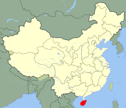
The Zhongsha Islands is a Chinese term for a collection of two skerries,many entirely submerged banks,seamounts,and shoals in the South China Sea. There are no islands in the Macclesfield Bank,the main part of Zhongsha. The Scarborough Shoal,which consists of two skerries,is not contiguous with the Macclesfield Bank,but Chinese sources treat them as one chain of geographical features. The whole of the region is claimed by both the PRC and the ROC,and various bits of the eastern parts are claimed by the Philippines. No country has constant control of the whole region,and there are disputes,such as the Scarborough Shoal standoff.
Contents
The PRC claims to administer the area as Zhongsha Daojiao Town (Chinese :中沙岛礁镇; pinyin :ZhōngshāDǎojiāo Zhèn),a town under the Xisha District of the Sansha prefecture-level city in Hainan. It has one Village-level division,Zhongsha Daojiao Residential Community. However,the seat of this town and residential community is not within the Zhongsha Islets,but on Woody Island.
Aquaculture research has been conducted on Walker Shoal (Chinese :漫步暗沙; pinyin :MànbùÀnshā). [1]