
Zoning is a method of urban planning in which a municipality or other tier of government divides land into areas called zones, within which certain land uses are permitted or prohibited. Zones may be defined for a single use, or may combine several compatible uses.
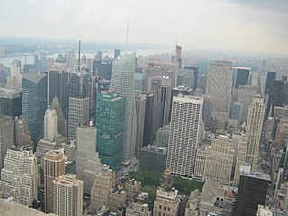
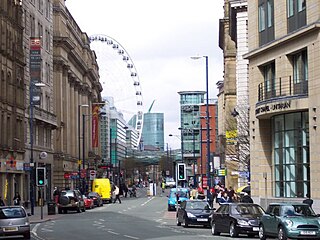
Downtown is a term primarily used in North America by English-speakers to refer to a city's commercial, cultural and often the historical, political and geographic heart, and is often synonymous with its central business district (CBD). It is marked by a cluster of tall buildings, cultural institutions and the convergence of rail transit and bus lines. In British English, the term "city centre" is most often used instead.
Urban structure is the arrangement of land use in urban areas, in other words, how the land use of a city is set out. Urban planners, economists, and geographers have developed several models that explain where different types of people and businesses tend to exist within the urban setting. Urban structure can also refer to urban spatial structure, which concerns the arrangement of public and private space in cities and the degree of connectivity and accessibility.
Urban economics is broadly the economic study of urban areas; as such, it involves using the tools of economics to analyze urban issues such as crime, education, public transit, housing, and local government finance. More specifically, it is a branch of microeconomics that studies urban spatial structure and the location of households and firms.
The term inner city has been used, especially in the US, as a euphemism for lower-income residential districts, sometimes but not exclusively referring to African-American neighborhoods, in a downtown or city centre area. Sociologists sometimes turn this euphemism into a formal designation, applying the term "inner city" to such residential areas, rather than to geographically more central commercial districts.

A residential area is a land used in which housing predominates, as opposed to industrial and commercial areas. Housing may vary significantly between, and through, residential areas. These include single-family housing, multi-family residential, or mobile homes. Zoning for residential use may permit some services or work opportunities or may totally exclude business and industry. It may permit high density land use or only permit low density uses. Residential zoning usually includes a smaller FAR than business, commercial or industrial/manufacturing zoning. The area may be large or small.

The concentric zone model, also known as the Burgess model or the CCD model, is one of the earliest theoretical models to explain urban social structures. It was created by sociologist Ernest Burgess in 1925.

The sector model, also known as the Hoyt model, is a model of urban land use proposed in 1939 by land economist Homer Hoyt. It is a modification of the concentric zone model of city development. The benefits of the application of this model include the fact it allows for an outward progression of growth. As with all simple models of such complex phenomena, its validity is limited.

The multiple nuclei model is an economical model created by Chauncy Harris and Edward Ullman in the 1945 article "The Nature of Cities".
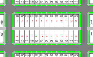
A city block, residential block, urban block or simply block is a central element of urban planning and urban design.
Urban morphology is the study of the form of human settlements and the process of their formation and transformation. The study seeks to understand the spatial structure and character of a metropolitan area, city, town or village by examining the patterns of its component parts and the ownership or control and occupation. Typically, analysis of physical form focuses on street pattern, lot pattern and building pattern, sometimes referred to collectively as urban grain. Analysis of specific settlements is usually undertaken using cartographic sources and the process of development is deduced from comparison of historic maps.

The Central Area, also called the City Area, and informally The City, is the city centre of Singapore. Located in the south-eastern part of the Central Region, the Central Area consists of eleven constituent planning areas, the Downtown Core, Marina East, Marina South, the Museum Planning Area, Newton, Orchard, Outram, River Valley, Rochor, the Singapore River and Straits View, as defined by the Urban Redevelopment Authority. The term Central Business District (CBD) has also been used to describe most of the Central Area as well, although its boundaries lie within the Downtown Core.
The urban-to-ruraltransect is an urban planning model created by New Urbanist Andrés Duany. The transect defines a series of zones that transition from sparse rural farmhouses to the dense urban core. Each zone is fractal in that it contains a similar transition from the edge to the center of the neighborhood. The transect is an important part of the New Urbanism and smart growth movements. Duany's firm DPZ has embodied the transect philosophy into their SmartCode generic planning code for municipal ordinances.
Ernest Watson Burgess was a Canadian-American urban sociologist born in Tilbury, Ontario. He was educated at Kingfisher College in Oklahoma and continued graduate studies in sociology at the University of Chicago. In 1916, he returned to the University of Chicago, as a faculty member. Burgess was hired as an urban sociologist at the University of Chicago. Burgess also served as the 24th President of the American Sociological Association (ASA).

In sociology, the social disorganization theory is a theory developed by the Chicago School, related to ecological theories. The theory directly links crime rates to neighbourhood ecological characteristics; a core principle of social disorganization theory that states location matters. In other words, a person's residential location is a substantial factor shaping the likelihood that that person will become involved in illegal activities. The theory suggests that, among determinants of a person's later illegal activity, residential location is as significant as or more significant than the person's individual characteristics. For example, the theory suggests that youths from disadvantaged neighborhoods participate in a subculture which approves of delinquency, and that these youths thus acquire criminality in this social and cultural setting.

Mixed-use development is a term used for two related concepts:

The bid rent theory is a geographical economic theory that refers to how the price and demand for real estate change as the distance from the central business district (CBD) increases. It states that different land users will compete with one another for land close to the city centre. This is based upon the idea that retail establishments wish to maximize their profitability, so they are much more willing to pay more for land close to the CBD and less for land further away from this area. This theory is based upon the reasoning that the more accessible an area, the more profitable.

The Core frame model is a model showing the urban structure of the Central Business District of a town or city. The model was first suggested by Ronald R. Boyce and Edgar M. Horwood in 1959.

The Central City Red Zone, also known as the CBD Red Zone, was a public exclusion zone in the Christchurch Central City implemented after the 22 February 2011 Christchurch earthquake. After February 2013, it was officially renamed the CBD Rebuild Zone by government agencies, but remained known as the Red Zone. It gradually shrank in size and the last cordons were removed on 30 June 2013, 859 days after the earthquake.
The City is a book by American urban sociologists Robert E. Park and Ernest W. Burgess published in 1925.

