Regional science is a field of the social sciences concerned with analytical approaches to problems that are specifically urban, rural, or regional. Topics in regional science include, but are not limited to location theory or spatial economics, location modeling, transportation, migration analysis, land use and urban development, interindustry analysis, environmental and ecological analysis, resource management, urban and regional policy analysis, geographical information systems, and spatial data analysis. In the broadest sense, any social science analysis that has a spatial dimension is embraced by regional scientists.

Zoning is a method of urban planning in which a municipality or other tier of government divides land into areas called zones, each of which has a set of regulations for new development that differs from other zones. Zones may be defined for a single use, they may combine several compatible activities by use, or in the case of form-based zoning, the differing regulations may govern the density, size and shape of allowed buildings whatever their use. The planning rules for each zone, determine whether planning permission for a given development may be granted. Zoning may specify a variety of outright and conditional uses of land. It may indicate the size and dimensions of lots that land may be subdivided into, or the form and scale of buildings. These guidelines are set in order to guide urban growth and development.

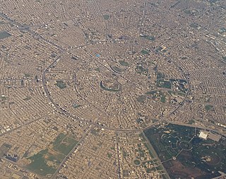
A metropolitan area or metro is a region consisting of a densely populated urban core and its less-populated surrounding territories under the same administrative division, sharing industry, infrastructure and housing. A metro area usually comprises multiple jurisdictions and municipalities: neighborhoods, townships, boroughs, cities, towns, exurbs, suburbs, counties, districts, states, and even nations like the eurodistricts. As social, economic and political institutions have changed, metropolitan areas have become key economic and political regions.

A central business district (CBD) is the commercial and business center of a city. It contains commercial space and offices. In larger cities, it is often synonymous with the city's "financial district". Geographically, it often coincides with the "city center" or "downtown", but the concepts are not mutually exclusive: many cities have a central business district located away from its commercial and or cultural center and or downtown/city center, or even several CBDs at once. For instance, London's city center is usually regarded as encompassing the historic City of London and the medieval City of Westminster, while the City of London and the transformed Docklands area containing Canary Wharf are regarded as its two respective CBDs. In New York City, Midtown Manhattan is the largest central business district in the city and in the world. In Chicago, the Chicago Loop is the second largest central business district in the United States and in the world. It is also referred to as the core of the city's downtown. Mexico City also has its own historic city center, the colonial-era "Centro Histórico," along with two CBDs: the mid-late 20th century Paseo de la Reforma – Polanco, and the new Santa Fe, respectively. Moscow and Russia's largest central business district is the Moscow International Business Center.
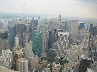
Downtown is a term primarily used in North America by English speakers to refer to a city's commercial, cultural and often the historical, political and geographic heart, and is often synonymous with its central business district (CBD). It is marked by a cluster of tall buildings, cultural institutions and the convergence of rail transit and bus lines. In British English, the term "city centre" is most often used instead.
Urban structure is the arrangement of land use in urban areas, in other words, how the land use of a city is set out. Urban planners, economists, and geographers have developed several models that explain where different types of people and businesses tend to exist within the urban setting. Urban structure can also refer to urban spatial structure, which concerns the arrangement of public and private space in cities and the degree of connectivity and accessibility.
Urban economics is broadly the economic study of urban areas; as such, it involves using the tools of economics to analyze urban issues such as crime, education, public transit, housing, and local government finance. More specifically, it is a branch of microeconomics that studies urban spatial structure and the location of households and firms.
The term inner city has been used, especially in the United States, as a euphemism for lower-income residential districts that often refer to African-American neighborhoods, in a downtown or city centre area. Sociologists sometimes turn the euphemism into a formal designation by applying the term "inner city" to such residential areas, rather than to more geographically-central commercial districts.

The concentric zone model, also known as the Burgess model or the CCD model, is one of the earliest theoretical models to explain urban social structures. It was created by sociologist Ernest Burgess in 1925.

The sector model, also known as the Hoyt model, is a model of urban land use proposed in 1939 by land economist Homer Hoyt. It is a modification of the concentric zone model of city development. The benefits of the application of this model include the fact it allows for an outward progression of growth. As with all simple models of such complex phenomena, its validity is limited.
Land-use forecasting undertakes to project the distribution and intensity of trip generating activities in the urban area. In practice, land-use models are demand-driven, using as inputs the aggregate information on growth produced by an aggregate economic forecasting activity. Land-use estimates are inputs to the transportation planning process.

The Central Area, also called the City Area, and informally The City, is the city centre of Singapore. Located in the south-eastern part of the Central Region, the Central Area consists of eleven constituent planning areas, the Downtown Core, Marina East, Marina South, the Museum Planning Area, Newton, Orchard, Outram, River Valley, Rochor, the Singapore River and Straits View, as defined by the Urban Redevelopment Authority. The term Central Business District (CBD) has also been used to describe most of the Central Area as well, although its boundaries lie within the Downtown Core.
The urban-to-ruraltransect is an urban planning model created by the New Urbanist Andrés Duany. The transect defines a series of zones that transition from sparse rural farmhouses to the dense urban core. Each zone is fractal in that it contains a similar transition from the edge to the center of the neighborhood. The transect is an important part of the New Urbanism and smart growth movements. Duany's firm DPZ has embodied the transect philosophy into their SmartCode generic planning code for municipal ordinances.

Mixed-use development is a term used for two related concepts:

The bid rent theory is a geographical economic theory that refers to how the price and demand for real estate change as the distance from the central business district (CBD) increases. It states that different land users will compete with one another for land close to the city centre. This is based upon the idea that retail establishments wish to maximize their profitability, so they are much more willing to pay more for land close to the CBD and less for land further away from this area. This theory is based upon the reasoning that the more accessible an area, the more profitable.
Zone of transition is the area between the factory zone and the working-class zone in the concentric zone model of urban structure devised by Ernest Burgess. The zone of transition is an area of flux where the land use is changing.
Urban sociology is the sociological study of social life and human interaction in metropolitan areas. It is a normative discipline of sociology seeking to study the structures, processes, changes and problems of an urban area and by doing so providing inputs for planning and policy making.
A business improvement district (BID) is a defined area within which businesses are required to pay an additional tax in order to fund projects within the district's boundaries. The BID is often funded primarily through the levy but can also draw on other public and private funding streams. BIDs may go by other names, such as business improvement area (BIA), business revitalization zone (BRZ), community improvement district (CID), special services area (SSA), or special improvement district (SID). These districts typically fund services which are perceived by some businesses as being inadequately performed by government with its existing tax revenues, such as cleaning streets, providing security, making capital improvements, construction of pedestrian and streetscape enhancements, and marketing the area. The services provided by BIDs are supplemental to those already provided by the municipality. The revenue derives from a tax assessment on commercial property owners, and in some cases, residential property owners.
Innovation districts are zones in cities where public and private actors work to attract entrepreneurs, startups, business incubators, generally with the aim of revitalizing depressed downtown areas. The first, 22@ in Barcelona, Spain, was launched in 2000; as of 2019, there are more than 80 worldwide.

Urban planning, also known as regional planning, town planning, city planning, or rural planning, is a technical and political process that is focused on the development and design of land use and the built environment, including air, water, and the infrastructure passing into and out of urban areas, such as transportation, communications, and distribution networks and their accessibility. Traditionally, urban planning followed a top-down approach in master planning the physical layout of human settlements. The primary concern was the public welfare, which included considerations of efficiency, sanitation, protection and use of the environment, as well as effects of the master plans on the social and economic activities. Over time, urban planning has adopted a focus on the social and environmental bottom-lines that focus on planning as a tool to improve the health and well-being of people while maintaining sustainability standards. Sustainable development was added as one of the main goals of all planning endeavors in the late 20th century when the detrimental economic and the environmental impacts of the previous models of planning had become apparent.. Similarly, in the early 21st century, Jane Jacob's writings on legal and political perspectives to emphasize the interests of residents, businesses and communities effectively influenced urban planners to take into broader consideration of resident experiences and needs while planning.
