Kololo is a hill in Kampala, the largest city and capital of Uganda. The name also applies to the upscale residential and commercial neighbourhood that sits on that hill.
Mengo is a hill in Rubaga Division, Kampala, Uganda's capital and largest city. The name also applies to the neighborhood on that hill.

Nakasero is a hill and neighborhood in the centre of Kampala, the capital and largest city of Uganda. Nakasero is important to Uganda's economy and politics, as it is home to Kampala's central business district and several government offices, including the Ugandan Parliament Buildings.
Nakawa is an area in the city of Kampala, Uganda's capital. It is also the location of the headquarters of Nakawa Division, one of the five administrative divisions of Kampala.
Nakawa Division is one of the five administrative divisions of the city of Kampala, the capital and largest city of Uganda. The town of Nakawa is the site of the division headquarters.
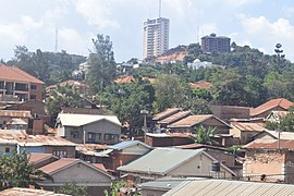
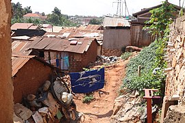
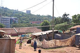
Namuwongo is a location in Kampala, the capital of Uganda and the largest city in that country.
Mbuya is a hill in southeastern Kampala, the capital city of Uganda. The hill rises 1,300 metres (4,300 ft) above sea level. The name also applies to the upscale residential neighborhood that sits on that hill, as well as the government military installations located there.
Ntinda is a location in northeastern Kampala, the capital city of Uganda.
Kibuli is a hill in the centre of Kampala, the capital and largest city in Uganda. The area is a suburb in the city centre and its name also applies to the commercial and residential neighbourhoods on that hill.
Kisaasi is a location, within the city of Kampala, Uganda.
Bugoloobi sometimes spelled as Bugolobi, is a location in Kampala, Uganda's capital and largest city. It is a suburban neighborhood and some of the most valuable properties in Kampala are found here. It is among the most developed neighborhoods in Kampala and Uganda in general.
Kamwookya, sometimes spelled as Kamwokya, is a location within the city of Kampala, Uganda's capital and largest metropolitan area.
Naguru General Hospital, also known as China-Uganda Friendship Hospital Naguru, is a hospital in Uganda. It is an urban, general hospital built between 2009 and 2012, at an estimated cost of approximately US$8 million. The hospital was built by the Government of China, as a gift to the Government of Uganda.
Kampala Central Division is one of the five divisions that make up Kampala, the capital of Uganda. The city's five divisions are: (a) Kampala Central Division (b) Kawempe Division (c) Lubaga Division (d) Makindye Division and (e) Nakawa Division.
Akright City is a residential community in Wakiso District of the Central Region of Uganda.
The JLOS House Project, is a proposed three-component government office development project in Uganda's capital city of Kampala, to house the offices of the Justice, Law and Order Sector (JLOS). The three components of the project are:
The Nakawa–Naguru Estates is a mixed, urban, commercial and residential real estate development, under construction in Uganda.
Lugogo is an area in the city of Kampala, Uganda's capital.
Uganda Manufacturers' Association (UMA), is an industry-association in Uganda, that aims to bring together Ugandan industrialists and manufacturers in an attempt to guide the industrial actors in the country towards global competitiveness, on a sustainable basis. The association advises the government of Uganda in the formulation of national and regional industrial policy. UMA also serves as a collective lobby and mouthpiece for its members.
Bugoloobi Wastewater Treatment Plant (BWTP), also Bugoloobi Sewerage Treatment Plant (BSTP), is a wastewater treatment project in Uganda. It is the largest wastewater treatment plant in the countries of the East African Community, and capable of processing 45,000,000 liters (45,000 m3) of wastewater daily.