The 1898 Atlantic hurricane season marked the beginning of the Weather Bureau operating a network of observation posts across the Caribbean Sea to track tropical cyclones, established primarily due to the onset of the Spanish–American War. A total of eleven tropical storms formed, five of which intensified into a hurricane, according to HURDAT, the National Hurricane Center's official database. Further, one cyclone strengthened into a major hurricane. However, in the absence of modern satellite and other remote-sensing technologies, only storms that affected populated land areas or encountered ships at sea were recorded, so the actual total could be higher. An undercount bias of zero to six tropical cyclones per year between 1851 and 1885 and zero to four per year between 1886 and 1910 has been estimated. The first system was initially observed on August 2 near West End in the Bahamas, while the eleventh and final storm dissipated on November 4 over the Mexican state of Veracruz.

The 1897 Atlantic hurricane season was an inactive season, featuring only six known tropical cyclones, four of which made landfall. There were three hurricanes, none of which strengthened into major hurricanes, which are Category 3 or higher on the modern-day Saffir–Simpson hurricane wind scale. The first system was initially observed south of Cape Verde on August 31, an unusually late date. The storm was the strongest of the season, peaking as a Category 2 hurricane with winds of 100 mph (155 km/h). While located well north of the Azores, rough seas by the storm sunk a ship, killing all 45 crewmen. A second storm was first spotted in the Straits of Florida on September 10. It strengthened into a hurricane and tracked northwestward across the Gulf of Mexico, striking Louisiana shortly before dissipating on September 13. This storm caused 29 deaths and $150,000 (1897 USD) in damage.

The 1895 Atlantic hurricane season ran through the summer and the first half of fall in 1895. The season was a fairly inactive one, with six storms forming, only two of which became hurricanes.

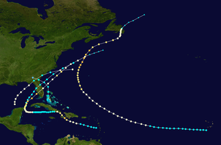
The 1893 Atlantic hurricane season ran through the summer and the first half of fall in 1893. The 1893 season was fairly active, with 12 tropical storms forming, 10 of which became hurricanes. Of those, five became major hurricanes. This season proved to be a very deadly season, with two different hurricanes each causing over 2,000 deaths in the United States; at the time, the season was the deadliest in U.S. history. The season was one of two seasons on record to see four Atlantic hurricanes active simultaneously, along with the 1998 Atlantic hurricane season. Additionally, August 15, 1893 was the only time since the advent of modern record keeping that three storms have formed on the same day until 2020 saw Wilfred, Alpha, and Beta forming on the same day; and for the first time, there were two high-intensity hurricanes simultaneously in one month of August, and this was not repeated until the year 2023.

The 1890 Atlantic hurricane season was among the least active Atlantic hurricane seasons on record. The first tropical cyclone of the season was initially observed on May 27 and the last storm, Hurricane Four, dissipated over Central America on November 1. These dates fall within the period with the most tropical cyclone activity in the Atlantic. The first storm moved slowly north-northwestward, bringing heavy rains and extensive flooding to Cuba, which caused at least three fatalities and at least $1 million (1890 USD) in damage. It dissipated in the Gulf of Mexico on May 29. Tropical cyclogenesis went dormant for nearly two and a half months, until another system was observed near the Windward Islands on August 18. It traversed the Caribbean Sea and Gulf of Mexico, grazing the Yucatan Peninsula and making landfall in Louisiana before dissipating on August 28. Impact from the storm was minimal.
The 1892 Atlantic hurricane season included the last tropical cyclone on record to pass through the Cabo Verde Islands at hurricane intensity until 2015. A total of nine tropical storms developed, five of which strengthened into a hurricane, though none of them became a major hurricane. However, in the absence of modern satellite and other remote-sensing technologies, only storms that affected populated land areas or encountered ships at sea were recorded, so the actual total could be higher. An undercount bias of zero to six tropical cyclones per year between 1851 and 1885 and zero to four per year between 1886 and 1910 has been estimated. Three tropical storms made landfall on the United States.

The 1891 Atlantic hurricane season began during the summer and ran through the late fall of 1891. The season had ten tropical cyclones. Seven of these became hurricanes; one becoming a major Category 3 hurricane.

The 1880 Atlantic hurricane season ran through the summer and fall of 1880. This is the period of each year when most tropical cyclones form in the Atlantic basin. In the 1880 Atlantic season there were two tropical storms, seven hurricanes, and two major hurricanes (Category 3+). However, in the absence of modern satellite and other remote-sensing technologies, only storms that affected populated land areas or encountered ships at sea were recorded, so the actual total could be higher. An undercount bias of zero to six tropical cyclones per year between 1851 and 1885 and zero to four per year between 1886 and 1910 has been estimated. Of the known 1880 cyclones, Hurricane Six was first documented in 1995 by José Fernández-Partagás and Henry Díaz. They also proposed large changes to the known tracks of several other storms for this year and 're-instated' Hurricane Ten to the database. A preliminary reanalysis by Michael Chenoweth, published in 2014, found thirteen storms, nine hurricanes, and four major hurricanes.

The 1887 Atlantic hurricane season was the most active Atlantic hurricane season on record at the time in terms of number of known tropical storms formed, with 19. This total has since been equaled or surpassed multiple times. The 1887 season featured five off-season storms, with tropical activity occurring as early as May, and as late as December. It is also worthy of note that the volume of recorded activity was documented largely without the benefit of modern technology. Tropical cyclones during this era that did not approach populated areas or shipping lanes, especially if they were relatively weak and of short duration, may have remained undetected. Because technologies such as satellite monitoring were not available until the 1960s, historical data on tropical cyclones from this period may not be comprehensive. An undercount bias of zero to six tropical cyclones per year between 1851 and 1885 and zero to four per year between 1886 and 1910 has been estimated. Of the known 1887 cyclones, Tropical Storm One and Tropical Storm Three were first documented in 1996 by Jose Fernandez-Partagas and Henry Diaz. They also proposed large alterations to the known tracks of several of the other 1887 storms. Later re-analysis led to the known duration of Hurricane Six, and also that of Hurricane Fifteen, being increased.

The 1870 Atlantic hurricane season marked the beginning of Father Benito Viñes investigating tropical cyclones, inspired by two hurricanes that devastated Cuba that year; Viñes consequently became a pioneer in studying and forecasting such storms. The season featured 11 known tropical cyclones, 10 of which became a hurricane, while 2 of those intensified into major hurricanes. However, in the absence of modern satellite and other remote-sensing technologies, only storms that affected populated land areas or encountered ships at sea were recorded, so the actual total could be higher. An undercount bias of zero to six tropical cyclones per year between 1851 and 1885 and zero to four per year between 1886 and 1910 has been estimated.
The 1881 Atlantic hurricane season ran through the summer and early fall of 1881. This is the period of each year when most tropical cyclones form in the Atlantic basin. In the 1881 Atlantic season there were three tropical storms and four hurricanes, none of which became major hurricanes. However, in the absence of modern satellite and other remote-sensing technologies, only storms that affected populated land areas or encountered ships at sea were recorded, so the actual total could be higher. An undercount bias of zero to six tropical cyclones per year between 1851 and 1885 and zero to four per year between 1886 and 1910 has been estimated. Of the known 1881 cyclones, Hurricane Three and Tropical Storm Seven were both first documented in 1996 by Jose Fernandez-Partagas and Henry Diaz. They also proposed changes to the known tracks of Hurricane Four and Hurricane Five.

The 1854 Atlantic hurricane season featured five known tropical cyclones, three of which made landfall in the United States. At one time, another was believed to have existed near Galveston, Texas in September, but HURDAT – the official Atlantic hurricane database – now excludes this system. The first system, Hurricane One, was initially observed on June 25. The final storm, Hurricane Five, was last observed on October 22. These dates fall within the period with the most tropical cyclone activity in the Atlantic. No tropical cyclones during this season existed simultaneously. One tropical cyclone has a single known point in its track due to a sparsity of data.

The 1853 Atlantic hurricane season featured eight known tropical cyclones, none of which made landfall. Operationally, a ninth tropical storm was believed to have existed over the Dominican Republic on November 26, but HURDAT – the official Atlantic hurricane database – now excludes this system. The first system, Tropical Storm One, was initially observed on August 5. The final storm, Hurricane Eight, was last observed on October 22. These dates fall within the period with the most tropical cyclone activity in the Atlantic. At two points during the season, pairs of tropical cyclones existed simultaneously. Four of the cyclones only have a single known point in their tracks due to a sparsity of data, so storm summaries for those systems are unavailable.

The 1877 Atlantic hurricane season lasted from mid-summer to late-fall. Records show that in 1877 there were eight cyclones, of which five were tropical storms and three were hurricanes, one of which became a major hurricane. However, in the absence of modern satellite and other remote-sensing technologies, only storms that affected populated land areas or encountered ships at sea were recorded, so the actual total could be higher. An undercount bias of zero to six tropical cyclones per year between 1851 and 1885 and zero to four per year between 1886 and 1910 has been estimated.

The 1876 Atlantic hurricane season featured the first hurricane landfall in North Carolina since 1861. Overall, the season was relatively quiet, with five tropical storms developing. Four of these became a hurricane, of which two intensified into major hurricanes. However, due to the absence of remote-sensing satellite and other technology, only storms that affected populated land areas or encountered ships at sea were recorded; therefore, the actual total could be higher. An undercount bias of zero to six tropical cyclones per year between 1851 and 1885 and zero to four per year between 1886 and 1910 has been estimated.
The 1873 Atlantic hurricane season was quiet, featuring only five known tropical cyclones, but all of them made landfall, causing significant impacts in some areas of the basin. Of these five systems, three intensified into a hurricane, while two of those attained major hurricane status. However, in the absence of modern satellite and other remote-sensing technologies, only storms that affected populated land areas or encountered ships at sea were recorded, so the actual total could be higher. An undercount bias of zero to six tropical cyclones per year between 1851 and 1885 and zero to four per year between 1886 and 1910 has been estimated.

The 1872 Atlantic hurricane season included a storm whose track became one of the first to be published by the United States Army Signal Service, a predecessor of the National Weather Service. The season was quiet, with only five documented tropical cyclones, of which four attained hurricane status. None of them intensified into a major hurricane. However, in the absence of modern satellite and other remote-sensing technologies, only storms that affected populated land areas or encountered ships at sea were recorded, so the actual total could be higher. An undercount bias of zero to six tropical cyclones per year between 1851 and 1885 and zero to four per year between 1886 and 1910 has been estimated.

The 1869 Atlantic hurricane season was the earliest season in the Atlantic hurricane database in which there were at least ten tropical cyclones. Initially there were only three known storms in the year, but additional research uncovered the additional storms. Meteorologist Christopher Landsea estimates up to six storms may remain missing from the official database for each season in this era, due to small tropical cyclone size, sparse ship reports, and relatively unpopulated coastlines. All activity occurred in a three-month period between the middle of August and early October.

The 1863 Atlantic hurricane season featured five landfalling tropical cyclones. In the absence of modern satellite and other remote-sensing technologies, only storms that affected populated land areas or encountered ships at sea were recorded, so the actual total could be higher. An undercount bias of zero to six tropical cyclones per year between 1851 and 1885 has been estimated. There were seven recorded hurricanes and no major hurricanes, which are Category 3 or higher on the modern day Saffir–Simpson scale. Of the known 1863 cyclones, seven were first documented in 1995 by José Fernández-Partagás and Henry Diaz, while the ninth tropical storm was first documented in 2003. These changes were largely adopted by the National Oceanic and Atmospheric Administration's Atlantic hurricane reanalysis in their updates to the Atlantic hurricane database (HURDAT), with some adjustments.

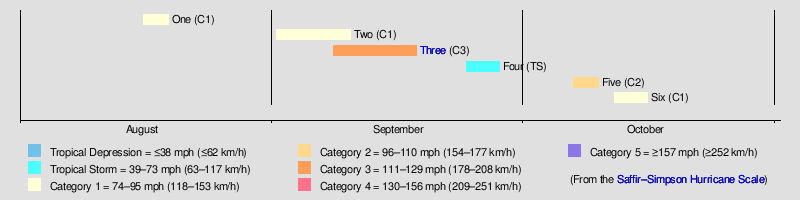
The 1875 Indianola hurricane brought a devastating and deadly storm surge to the coast of Texas. The third known system of the 1875 Atlantic hurricane season, the storm was first considered a tropical cyclone while located east of the Lesser Antilles on September 8. After passing through the Windward Islands and entering the Caribbean Sea, the cyclone gradually began to move more northwestward and brushed the Tiburon Peninsula of Haiti late on September 12. On the following day, the storm made a few landfalls on the southern coast of Cuba before moving inland over Sancti Spíritus Province. The system emerged into the Gulf of Mexico near Havana and briefly weakened to a tropical storm. Thereafter, the storm slowly re-intensified and gradually turned westward. On September 16, the hurricane peaked as a Category 3 hurricane with winds of 115 mph (185 km/h). Later that day, the hurricane made landfall near Indianola, Texas. The storm quickly weakened and turned northeastward, before dissipating over Mississippi on September 18.