Patagonia is a town in Santa Cruz County, Arizona, United States. As of the 2010 census it had a population of 913. It developed in the mid-19th century as a trading and supply center for nearby mines and ranches. In the 21st century, it is a tourist destination, retirement community, and arts and crafts center.
Santa Rita is a ghost town in Grant County in the U.S. state of New Mexico. The site of Chino copper mine, Santa Rita was located fifteen miles east of Silver City.

Ruby is a ghost town in Santa Cruz County, Arizona, United States. It was founded as a mining town in Bear Valley, originally named Montana Camp, so named because the miners were mining at the foot of Montana Peak.

Kentucky Camp is a ghost town and former mining camp along the Arizona Trail in Pima County, Arizona, United States, near the community of Sonoita. The Kentucky Camp Historic District is listed on the National Register of Historic Places and has been since 1995. As it is located within Coronado National Forest, the United States Forest Service is responsible for the upkeep of the remaining buildings within the Kentucky Camp Historic District.
Silver mining in Arizona was a powerful stimulus for exploration and prospecting in early Arizona. Cumulative silver production through 1981 totaled 490 million troy ounces. However, only about 10% of Arizona's silver production came from silver mining. More than 80% of the state's silver was a byproduct of copper mining; other silver came as a byproduct of lead, zinc, and gold mining.

Sasco is a ghost town located in Pinal County, Arizona, west of Red Rock. Sasco, which is an acronym for the Southern Arizona Smelter Company, was a company town with a large smelter that served several mines. Once an impressive and little-known ghost town, today Sasco is a common sporting destination with shotgun shells, airsoft bb's, paintball splatter, and litter in the area.

The Castle Dome Mountains are a mountain range in Yuma County, Arizona, within the Kofa National Wildlife Refuge. Castle Dome Peak, the high point of the range, is a prominent butte and distinctive landmark. The peak is 3,780 feet (1,152 m) high, and is located at 33°05′04″N 114°08′36″W. Castle Dome was named by American soldiers at old Fort Yuma in the 1880s. Early Spanish explorers called the same peak Cabeza de Gigante, "Giant's Head."

Helvetia is a ghost town in Pima County, Arizona, United States that was settled in 1891 and abandoned in the early 1920s. Helvetia is an ancient name for Switzerland. Today, only the Ray Mine and cemetery are visitable, as the rest of the town has been fenced off due to active mining operations.

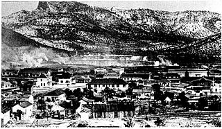
Harshaw is a ghost town in Santa Cruz County in the southeastern part of the U.S. state of Arizona. The town was settled in the 1870s, in what was then Arizona Territory. Founded as a mining community, Harshaw is named after the cattleman-turned-prospector David Tecumseh Harshaw, who first successfully located silver in the area. At the town's peak near the end of the 19th century, Harshaw's mines were among Arizona's highest producers of ore, with the largest mine, the Hermosa, yielding approximately $365,455 in bullion over a four-month period in 1880.

The Patagonia Mountains are a 15-mile-long (24 km) mountain range within the Coronado National Forest, and in Santa Cruz County, Arizona, United States.
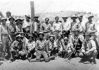
The Ruby Murders is the popular name for three separate incidents involving the deaths of six American citizens near the town of Ruby, Arizona. The first incident occurred in February 1920 when Mexican bandits robbed and killed the two owners of the Ruby Mercantile. A second attack happened in April 1921 when Mexican bandits robbed and killed the store's new owners. Two of the bandits were arrested for the crime, but they briefly escaped custody in July 1922 after killing another two men, which led to the largest manhunt in the history of the Southwest.

Lochiel is a populated place and former border crossing in southern Santa Cruz County, Arizona, United States, approximately 25 miles east of Nogales. Basically a ghost town, the townsite is located in the southwestern part of the San Rafael Valley on Washington Gulch, about 1.5 miles west of the Santa Cruz River. It was first settled in the late-1870s and mostly abandoned by 1986. The town served the ranches of the San Rafael Valley and the Washington Camp and Duquesne mining towns of the Patagonia Mountains, approximately five miles to the northwest up Washington Gulch.

San Xavier is a populated place in Pima County, Arizona, United States, situated seventeen miles southwest of Tucson, and six miles northwest of Sahuarita. Originally a small silver mining camp from the 1880s, today San Xavier is little more than a collection of rural homes and partially abandoned mines. The ghost towns of Azurite and Mineral Hill were located about one mile north of San Xavier. Twin Buttes was five miles southeast.
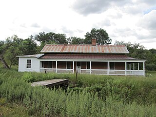
The James Finley House is a historic home located on the Hale Ranch in the ghost town of Harshaw, Arizona. Built around 1877, the house was added to the National Register of Historic Places in 1974, and is now the most prominent building remaining in this ghost town. Along with the rest of Harshaw, this house has been within the Coronado National Forest since 1953.

Duquesne is a ghost town in the Patagonia Mountains in eastern Santa Cruz County, Arizona, near the international border with Sonora, Mexico. The town, which is currently under private ownership and closed to the public although the roads are almost all public, was once the headquarters of the Duquesne Mining and Reduction Company and is the site of the Bonanza Mine. Washington Camp is approximately one mile northwest of Duquesne and was where the mine's reduction plant was located.

Salero is a ghost town in the Santa Rita Mountains of Santa Cruz County, Arizona. As one of the best preserved ghost towns remaining in Arizona, Salero is located on private property of the Salero Ranch and is not open to visitors.

Joseph Mayer was an American businessman, gold prospector and pioneer who founded the town of Mayer, Arizona.

The Historic Pinal Cemetery, first known simply as "Pinal Cemetery", is a cemetery located on a hill in what once within the jurisdiction of the now ghost town of Pinal City, Arizona. The Pioneers' Cemetery Association (PCA) defines a "historic cemetery" as one which has been in existence for more than fifty years. In 2009, the Tonto National Forest made it its goal to develop and manage the cemetery as an interpretive site while preserving its historic context and integrity as an archaeological resource. Among those who are buried in the cemetery is Celia Ann “Mattie” Blaylock Earp who was Wyatt Earp's common law wife. The role of Mattie Earp was played by actress Dana Wheeler-Nicholson in the 1993 American Western film Tombstone.