
A ghost town is an abandoned village, town, or city, usually one that contains substantial visible remaining buildings and infrastructure such as roads. A town often becomes a ghost town because the economic activity that supported it has failed or ended for any reason. The town may also have declined because of natural or human-caused disasters such as floods, prolonged droughts, extreme heat or extreme cold, government actions, uncontrolled lawlessness, war, pollution, or nuclear disasters. The term can sometimes refer to cities, towns, and neighbourhoods that, though still populated, are significantly less so than in past years; for example, those affected by high levels of unemployment and dereliction.

George Westinghouse Jr. was an American entrepreneur and engineer based in Pennsylvania who created the railway air brake and was a pioneer of the electrical industry, receiving his first patent at the age of 19. Westinghouse saw the potential of using alternating current for electric power distribution in the early 1880s and put all his resources into developing and marketing it. This put Westinghouse's business in direct competition with Thomas Edison, who marketed direct current for electric power distribution. In 1911 Westinghouse received the American Institute of Electrical Engineers's (AIEE) Edison Medal "For meritorious achievement in connection with the development of the alternating current system." He founded the Westinghouse Electric Corporation in 1886.

Patagonia is a town in Santa Cruz County, Arizona, United States. As of the 2010 census it had a population of 913. It developed in the mid-19th century as a trading and supply center for nearby mines and ranches. In the 21st century, it is a tourist destination, retirement community, and arts and crafts center.

Oatman is an unincorporated community and census-designated place (CDP) in the Black Mountains of Mohave County, Arizona, United States, located at an elevation of 2,710 feet (830 m). It began as a small mining camp when two prospectors struck a $10 million gold find in 1915, though the vicinity had already been settled for a number of years. Oatman's population grew to more than 3,500 in the course of a year. As of the 2020 census, its population was 102.

Ruby is a ghost town in Santa Cruz County, Arizona, United States. It was founded as a mining town in Bear Valley, originally named Montana Camp, so named because the miners were mining at the foot of Montana Peak.

Cherry is a mining ghost town in central Yavapai County, Arizona, United States, between Dewey and Camp Verde, located at an elevation of 5143 feet.
The Castle Dome Mountains are a mountain range in Yuma County, Arizona, within the Kofa National Wildlife Refuge. Castle Dome Peak, the high point of the range, is a prominent butte and distinctive landmark. The peak is 3,776 feet (1,151 m) high, and is located at 33°05′04″N114°08′36″W. Castle Dome was named by American soldiers at old Fort Yuma in the 1880s. Early Spanish explorers called the same peak Cabeza de Gigante, "Giant's Head."

Harshaw is a ghost town in Santa Cruz County in the southeastern part of the U.S. state of Arizona. The town was settled in the 1870s, in what was then Arizona Territory. Founded as a mining community, Harshaw is named after the cattleman-turned-prospector David Tecumseh Harshaw, who first successfully located silver in the area. At the town's peak near the end of the 19th century, Harshaw's mines were among Arizona's highest producers of ore, with the largest mine, the Hermosa, yielding approximately $365,455 in bullion over a four-month period in 1880.

Alamo Crossing is a ghost town in Mohave County, Arizona, United States. The town was settled in the late 1890s, in what was then the Arizona Territory. It served as a camp for mining prospectors in the manganese-rich Artillery Mountains, being the only town in the area. After 1918, the post office permanently closed, but the town was only intermittently abandoned, with its founders often present through until at least the mid-1950s. The town was intentionally flooded in 1968 to create Alamo Lake. In 2020, the area of Alamo was revived for mining again, this time for surface-level gold prospecting.
American Flag is a ghost town in Pinal County, Arizona, five miles southeast of Oracle. The town was established in the late 1870s but shortly after 1890, the town had become abandoned.
Bradshaw City is a ghost town in Yavapai County, Arizona, United States. It served as a mining camp from its founding in 1863 until the late 1880s. "Bradshaw City" is the namesake of its founder, William D. Bradshaw.
Cerbat is a ghost town just west of the Cerbat Mountains in Mohave County, Arizona, United States. Mining in the area began in the late 1860s and a camp was established soon after. Cerbat was built in a canyon 38 miles (61 km) from Hardyville. The town was prosperous and contained several mining and public buildings, along with cabins for over 100 settlers, as well as a school, a doctor's office and a lawyer's office. In the 1870s the town was connected by dirt road to Fort Rock, Camp Hualapai and Prescott. Cerbat was the third seat of Mohave County until 1877 when Mineral Park took the title.

The Patagonia Mountains are a 15-mile-long (24 km) mountain range within the Coronado National Forest, and in Santa Cruz County, Arizona, United States.
Christmas is an uninhabited mining community in Gila County, Arizona, United States. The mine which led to creation of the town was staked on Christmas Day 1902, prompting the name. During the three decades in which the town's post office operated it was a popular destination for holiday mail seeking a "Christmas" postmark. The mine is also the location where the minerals apachite, junitoite, and ruizite were first discovered.

Lochiel is a populated place and former border crossing in southern Santa Cruz County, Arizona, United States, approximately 25 miles east of Nogales. Basically a ghost town, the townsite is located in the southwestern part of the San Rafael Valley on Washington Gulch, about 1.5 miles west of the Santa Cruz River. It was first settled in the late-1870s and mostly abandoned by 1986. The town served the ranches of the San Rafael Valley and the Washington Camp and Duquesne mining towns of the Patagonia Mountains, approximately five miles to the northwest up Washington Gulch.

San Xavier is a populated place in Pima County, Arizona, United States, situated seventeen miles southwest of Tucson, and six miles northwest of Sahuarita. Originally a small silver mining camp from the 1880s, today San Xavier is little more than a collection of rural homes and partially abandoned mines. The ghost towns of Azurite and Mineral Hill were located about one mile north of San Xavier. Twin Buttes was five miles southeast.

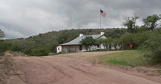
Duquesne is a ghost town in the Patagonia Mountains in eastern Santa Cruz County, Arizona, near the international border with Sonora, Mexico. The town, which is currently under private ownership and closed to the public although the roads are almost all public, was once the headquarters of the Duquesne Mining and Reduction Company and is the site of the Bonanza Mine. Washington Camp is approximately one mile northwest of Duquesne and was where the mine's reduction plant was located.


