| Part of series on |
| Technical drawings |
|---|
 |
Archaeological illustration is a form of technical illustration that records material derived from an archaeological context graphically. [1]
| Part of series on |
| Technical drawings |
|---|
| |
Archaeological illustration is a form of technical illustration that records material derived from an archaeological context graphically. [1]
Archaeological Illustration encompasses a number of sub disciplines. These are:


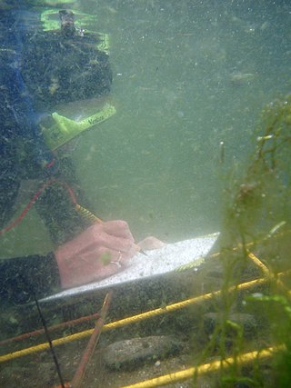
Underwater archaeology is archaeology practiced underwater. As with all other branches of archaeology, it evolved from its roots in pre-history and in the classical era to include sites from the historical and industrial eras. Its acceptance has been a relatively late development due to the difficulties of accessing and working underwater sites, and because the application of archaeology to underwater sites initially emerged from the skills and tools developed by shipwreck salvagers. As a result, underwater archaeology initially struggled to establish itself as actual archaeological research. This changed when universities began teaching the subject and a theoretical and practical base for the sub-discipline was firmly established in the late 1980’s. Underwater archaeology now has a number of branches including, maritime archaeology: the scientifically based study of past human life, behaviours and cultures and their activities in, on, around and (lately) under the sea, estuaries and rivers. This is most often effected using the physical remains found in, around or under salt or fresh water or buried beneath water-logged sediment. In recent years, the study of submerged WWII sites and of submerged aircraft in the form of underwater aviation archaeology have also emerged as bona fide activity.

In archaeology, excavation is the exposure, processing and recording of archaeological remains. An excavation site or "dig" is the area being studied. These locations range from one to several areas at a time during a project and can be conducted over a few weeks to several years.

An illustration is a decoration, interpretation or visual explanation of a text, concept or process, designed for integration in print and digital published media, such as posters, flyers, magazines, books, teaching materials, animations, video games and films. An illustration is typically created by an illustrator. Digital illustrations are often used to make websites and apps more user-friendly, such as the use of emojis to accompany digital type. llustration also means providing an example; either in writing or in picture form.

An illustrator is an artist who specializes in enhancing writing or elucidating concepts by providing a visual representation that corresponds to the content of the associated text or idea. The illustration may be intended to clarify complicated concepts or objects that are difficult to describe textually, which is the reason illustrations are often found in children's books.

Photogrammetry is the science and technology of obtaining reliable information about physical objects and the environment through the process of recording, measuring and interpreting photographic images and patterns of electromagnetic radiant imagery and other phenomena.
Aerial archaeology is the study of archaeological remains by examining them from a higher altitude. In present day, this is usually achieved by satellite images or through the use of drones.

Prehistoric archaeology is a subfield of archaeology, which deals specifically with artefacts, civilisations and other materials from societies that existed before any form of writing system or historical record. Often the field focuses on ages such as the Stone Age, Bronze Age and Iron Age, although it also encompasses periods such as the Neolithic. The study of prehistoric archaeology reflects the cultural concerns of modern society by showing interpretations of time between economic growth and political stability. It is related to other disciplines such as geology, biology, anthropology, historiography and palaeontology, although there are noticeable differences between the subjects they all broadly study to understand; the past, either organic or inorganic or the lives of humans. Prehistoric archaeology is also sometimes termed as anthropological archaeology because of its indirect traces with complex patterns.

The Royal Commission on the Ancient and Historical Monuments of Wales, established in 1908, is a Welsh Government sponsored body concerned with some aspects of the archaeological, architectural and historic environment of Wales. It is based in Aberystwyth.

In archaeology, survey or field survey is a type of field research by which archaeologists search for archaeological sites and collect information about the location, distribution and organization of past human cultures across a large area. Archaeologists conduct surveys to search for particular archaeological sites or kinds of sites, to detect patterns in the distribution of material culture over regions, to make generalizations or test hypotheses about past cultures, and to assess the risks that development projects will have adverse impacts on archaeological heritage. The surveys may be: (a) intrusive or non-intrusive, depending on the needs of the survey team and; (b) extensive or intensive, depending on the types of research questions being asked of the landscape in question. Surveys can be a practical way to decide whether or not to carry out an excavation, but may also be ends in themselves, as they produce important information about past human activities in a regional context.

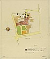
In archaeological excavation, a plan is a drawn record of features and artifacts in the horizontal plane.
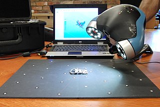
3D scanning is the process of analyzing a real-world object or environment to collect data on its shape and possibly its appearance. The collected data can then be used to construct digital 3D models.

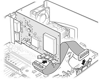
Graphic art software is a subclass of application software used for graphic design, multimedia development, stylized image development, technical illustration, general image editing, or simply to access graphic files. Art software uses either raster or vector graphic reading and editing methods to create, edit, and view art.
Oxford Archaeology is one of the largest and longest-established independent archaeology and heritage practices in Europe, operating from three permanent offices in Oxford, Lancaster and Cambridge, and working across the UK. OA is a Registered Organisation with the Chartered Institute for Archaeologists (CIfA), and carries out commercial archaeological fieldwork in advance of development, as well as a range of other heritage related services. Oxford Archaeology primarily operates in the UK, but has also carried out contracts around the world, including Sudan, Qatar, Central Asia, China and the Caribbean. Numbers of employees vary owing to the project-based nature of the work, but in 2014 OA employed over 220 people.
Technical Illustration is illustration meant to visually communicate information of a technical nature. Technical illustrations can be components of technical drawings or diagrams. Technical illustrations in general aim "to generate expressive images that effectively convey certain information via the visual channel to the human observer".
Piet Christiaan Leonardus de Jong was an artist who worked on the illustration and reconstruction of archaeological sites in the Mediterranean, including Mycenae, Knossos, Eutresis, Gordion, and the Athenian Agora.
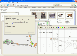
The Integrated Archaeological Database system, or IADB, is an open-source web-based application designed to address the data management requirements throughout the lifespan of archaeological excavation projects, from initial excavation recording, through post-excavation analysis and research to eventual dissemination and archiving.
Dominic Powlesland, is a British landscape archaeologist based in North Yorkshire. He has contributed to the methodologies of field archaeology and landscape survey, particularly geophysics and the use of computers when recording and processing archaeological data. He is the director of the Landscape Research Centre and visiting professor at the universities of York, Leeds, Huddersfield and Vienna.
This page is a glossary of archaeology, the study of the human past from material remains.
Digital archaeology is the application of information technology and digital media to archaeology. It includes the use of digital photography, 3D reconstruction, virtual reality, and geographical information systems, among other techniques. Computational archaeology, which covers computer-based analytical methods, can be considered a subfield of digital archaeology, as can virtual archaeology.
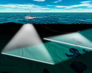
An underwater survey is a survey performed in an underwater environment or conducted remotely on an underwater object or region. Survey can have several meanings. The word originates in Medieval Latin with meanings of looking over and detailed study of a subject. One meaning is the accurate measurement of a geographical region, usually with the intention of plotting the positions of features as a scale map of the region. This meaning is often used in scientific contexts, and also in civil engineering and mineral extraction. Another meaning, often used in a civil, structural, or marine engineering context, is the inspection of a structure or vessel to compare actual condition with the specified nominal condition, usually with the purpose of reporting on the actual condition and compliance with, or deviations from, the nominal condition, for quality control, damage assessment, valuation, insurance, maintenance, and similar purposes. In other contexts it can mean inspection of a region to establish presence and distribution of specified content, such as living organisms, either to establish a baseline, or to compare with a baseline.