Armstrong | |
---|---|
City of Armstrong | |
Motto(s): "Spirit, Vision" | |
Location of Armstrong in British Columbia | |
Coordinates: 50°26′54″N119°11′46″W / 50.44833°N 119.19611°W | |
Country | Canada |
Province | British Columbia |
Regional District | North Okanagan |
Incorporated | 1913 |
Government | |
• Governing body | Armstrong City Council |
• Mayor | Joe Cramer |
• MP | Colin Mayes (Conservative) |
• MLA | Greg Kyllo (Liberal) |
Area | |
• City | 5.19 km2 (2.00 sq mi) |
Elevation | 360 m (1,180 ft) |
Population (2021) | |
• City | 5,323 |
• Density | 1,000/km2 (2,700/sq mi) |
• Urban | 4,830 [1] |
• Metro | 9,870 |
Time zone | UTC-8 (PST) |
Postal code | V0E 1B0 |
Area code | 250 / 778 / 236 / 672 |
Highways | 97A |
Waterways | Okanagan Lake |
Website | www |
Armstrong, officially the City of Armstrong is a city in the North Okanagan of the Canadian province of British Columbia, between Vernon and Enderby. It overlooks the Spallumcheen Valley, which forms a broad pass between the Okanagan Valley to the south and the Shuswap Country to the north, and is about 480 km (300 mi) from each of Vancouver, B.C. and Spokane, Washington. The town of Armstrong celebrated its centennial in 2013. [2]
Armstrong is a rural community and commercial center in the North Okanagan, with agriculture, grain farming of alfalfa and corn, logging, and ranching being traditional economic activities. It is located amidst the dairy and farmlands of the Spallumcheen Valley (a name derived from a Shuswap language word with multiple meanings: "beautiful valley", "flat meadow", "meeting of the waters", and "prairie-banked river").
Armstrong was named after William Heaton Armstrong, a London banker who helped finance the Shuswap and Okanagan Railway in 1892 and local development at the turn of the century, relocating the townsite originally at Landsdowne to the confluence of the Valley's rail lines, and the city's current site.
The influence of Dutch immigrants settling in the valley after the Second World War is represented by their cheese-making knowledge, allowing Armstrong to become well known for the cheese it produced.
The city is also well known for hosting the Interior Provincial Exhibition and Stampede, [3] which has been in annual operation since 1899 (however, the event was cancelled in 2020 and 2021 due to the COVID-19 pandemic). The "IPE" is not just a midway and popular retail show, but very much still a country fair, with contests being held to judge animals, cooking, sewing, hobbies, and other items. Additionally, the exhibition offers a variety of entertainment options ranging from concerts, competitions, and the famous mini-chuckwagon races.
Armstrong is a corporation operated by a seven-member city council headed by the Mayor, with meetings being held the second and fourth Mondays of every month. The Mayor is Chris Pieper, currently in his second term as mayor. He was preceded in his position by the prestigious Gerald "Jerry" Oglow.
Armstrong has four public education facilities; two elementary schools, a middle school, and a high school. Armstrong Elementary School was initially known as the "Armstrong Spallumcheen Consolidated School". When it was built in 1921, it was the first school in the Province to be constructed as a central school into which were consolidated approximately thirteen small country or one-room schools. Len Wood Middle school and Pleasant Valley Secondary were later added to suit the growing region, with Highland Park Elementary opening in 1983 to satisfy increasing demand and lack of suitable expansion capacity at Armstrong Elementary. There is also a store-front style facility, Gateway Continuing Education Centre, operated by School District 83. [4]
Year | Pop. | ±% |
---|---|---|
1921 | 983 | — |
1931 | 989 | +0.6% |
1941 | 977 | −1.2% |
1951 | 1,126 | +15.3% |
1956 | 1,197 | +6.3% |
1961 | 1,288 | +7.6% |
1966 | 1,426 | +10.7% |
1971 | 1,648 | +15.6% |
1976 | 2,260 | +37.1% |
1981 | 2,683 | +18.7% |
1986 | 2,706 | +0.9% |
1991 | 3,200 | +18.3% |
1996 | 3,906 | +22.1% |
2001 | 4,256 | +9.0% |
2006 | 4,241 | −0.4% |
2011 | 4,815 | +13.5% |
Sources: Statistics Canada [5] |
While agriculture, logging, and ranching remain a dominant portion of the economy of Armstrong and the Spallumcheen Valley, tourism increasingly plays a significant role in the economic activity of the area; particularly popular with long-distance cyclists as a desirable location for short-haul excursions.
Armstrong and the surrounding area feature many attractions including museums, golf courses, water sports, snow sports including skiing and snowmobile riding, boating, fishing and hiking trails.
Armstrong Cheese is well known throughout Canada and in parts of the United States, and originated in Armstrong. Dairyworld purchased Armstrong Cheese in 1997. Saputo Inc. purchased Dairyworld in 2003, and in February 2004, after being in operation for more than 100 years, closed the Armstrong Cheese site down, laying off 73 workers. However, one of the main tourist attractions continues to be the Village Cheese Company. [6] At the Village Cheese Company, one can watch master cheesemakers at their craft. Among the cheeses available are cheddar, Monterey Jack and "squeaky curds".
Armstrong has a humid continental climate (Köppen Dfb).
Climate data for Armstrong | |||||||||||||
---|---|---|---|---|---|---|---|---|---|---|---|---|---|
Month | Jan | Feb | Mar | Apr | May | Jun | Jul | Aug | Sep | Oct | Nov | Dec | Year |
Record high °C (°F) | 12.0 (53.6) | 13.0 (55.4) | 20.0 (68.0) | 31.7 (89.1) | 34.0 (93.2) | 37.0 (98.6) | 38.9 (102.0) | 37.0 (98.6) | 34.0 (93.2) | 25.5 (77.9) | 20.0 (68.0) | 12.5 (54.5) | 38.9 (102.0) |
Mean daily maximum °C (°F) | −1.1 (30.0) | 1.7 (35.1) | 9.4 (48.9) | 15.1 (59.2) | 20.0 (68.0) | 23.6 (74.5) | 26.5 (79.7) | 27.1 (80.8) | 20.7 (69.3) | 12.4 (54.3) | 3.9 (39.0) | −1.5 (29.3) | 13.1 (55.6) |
Daily mean °C (°F) | −4.4 (24.1) | −2.4 (27.7) | 3.4 (38.1) | 8.2 (46.8) | 12.6 (54.7) | 16.2 (61.2) | 18.5 (65.3) | 18.6 (65.5) | 13.0 (55.4) | 6.8 (44.2) | 0.5 (32.9) | −4.5 (23.9) | 7.2 (45.0) |
Mean daily minimum °C (°F) | −7.7 (18.1) | −6.6 (20.1) | −2.7 (27.1) | 1.1 (34.0) | 5.1 (41.2) | 8.8 (47.8) | 10.5 (50.9) | 10.1 (50.2) | 5.3 (41.5) | 1.2 (34.2) | −2.9 (26.8) | −7.4 (18.7) | 1.2 (34.2) |
Record low °C (°F) | −32.0 (−25.6) | −27.2 (−17.0) | −20.0 (−4.0) | −11.1 (12.0) | −3.0 (26.6) | −2.0 (28.4) | 3.0 (37.4) | 1.1 (34.0) | −5.0 (23.0) | −22.0 (−7.6) | −31.5 (−24.7) | −37.0 (−34.6) | −37.0 (−34.6) |
Average precipitation mm (inches) | 43.6 (1.72) | 28.9 (1.14) | 29.1 (1.15) | 34.0 (1.34) | 52.1 (2.05) | 60.3 (2.37) | 55.0 (2.17) | 38.3 (1.51) | 43.8 (1.72) | 40.4 (1.59) | 51.7 (2.04) | 51.3 (2.02) | 528.5 (20.81) |
Average rainfall mm (inches) | 6.3 (0.25) | 10.2 (0.40) | 26.2 (1.03) | 33.9 (1.33) | 52.1 (2.05) | 60.3 (2.37) | 55.0 (2.17) | 38.3 (1.51) | 43.8 (1.72) | 40.0 (1.57) | 32.6 (1.28) | 5.9 (0.23) | 404.6 (15.93) |
Average snowfall cm (inches) | 37.4 (14.7) | 18.6 (7.3) | 3.1 (1.2) | 0.1 (0.0) | 0.0 (0.0) | 0.0 (0.0) | 0.0 (0.0) | 0.0 (0.0) | 0.0 (0.0) | 0.4 (0.2) | 19.1 (7.5) | 45.4 (17.9) | 124.0 (48.8) |
Average precipitation days (≥ 0.2 mm) | 8.9 | 6.9 | 7.0 | 7.9 | 10.0 | 9.9 | 9.1 | 6.3 | 6.1 | 8.3 | 10.9 | 11.0 | 102.2 |
Average rainy days (≥ 0.2 mm) | 1.5 | 2.6 | 6.2 | 7.9 | 10.0 | 9.9 | 9.1 | 6.3 | 6.1 | 8.2 | 7.3 | 1.8 | 76.8 |
Average snowy days (≥ 0.2 cm) | 7.7 | 4.8 | 1.5 | 0.1 | 0.0 | 0.0 | 0.0 | 0.0 | 0.0 | 0.2 | 4.5 | 9.8 | 28.5 |
Source: [7] |
In the 2021 Census of Population conducted by Statistics Canada, Armstrong had a population of 5,323 living in 2,217 of its 2,292 total private dwellings, a change of 4.1% from its 2016 population of 5,114. With a land area of 5.22 km2 (2.02 sq mi), it had a population density of 1,019.7/km2 (2,641.1/sq mi) in 2021. [8]
Panethnic group | 2021 [9] | 2016 [10] | 2011 [11] | 2006 [12] | 2001 [13] | |||||||||
---|---|---|---|---|---|---|---|---|---|---|---|---|---|---|
Pop. | % | Pop. | % | Pop. | % | Pop. | % | Pop. | % | |||||
European [lower-alpha 1] | 4,560 | 89.15% | 4,415 | 89.64% | 4,255 | 91.02% | 3,765 | 90.83% | 3,965 | 94.97% | ||||
Indigenous | 375 | 7.33% | 345 | 7.01% | 315 | 6.74% | 245 | 5.91% | 140 | 3.35% | ||||
East Asian [lower-alpha 2] | 80 | 1.56% | 90 | 1.83% | 50 | 1.07% | 75 | 1.81% | 60 | 1.44% | ||||
South Asian | 40 | 0.78% | 10 | 0.2% | 0 | 0% | 10 | 0.24% | 10 | 0.24% | ||||
Southeast Asian [lower-alpha 3] | 25 | 0.49% | 15 | 0.3% | 0 | 0% | 10 | 0.24% | 10 | 0.24% | ||||
African | 20 | 0.39% | 15 | 0.3% | 20 | 0.43% | 0 | 0% | 0 | 0% | ||||
Latin American | 10 | 0.2% | 0 | 0% | 0 | 0% | 0 | 0% | 0 | 0% | ||||
Middle Eastern [lower-alpha 4] | 0 | 0% | 20 | 0.41% | 0 | 0% | 30 | 0.72% | 0 | 0% | ||||
Other/Multiracial [lower-alpha 5] | 0 | 0% | 15 | 0.3% | 0 | 0% | 0 | 0% | 0 | 0% | ||||
Total responses | 5,115 | 96.09% | 4,925 | 96.3% | 4,675 | 96.79% | 4,145 | 97.74% | 4,175 | 98.1% | ||||
Total population | 5,323 | 100% | 5,114 | 100% | 4,830 | 100% | 4,241 | 100% | 4,256 | 100% | ||||
Note: Totals greater than 100% due to multiple origin responses |
According to the 2021 census, religious groups in Armstrong included: [9]
The public schools system is administered by School District 83 North Okanagan-Shuswap, headquartered in nearby Salmon Arm. Pleasant Valley Secondary School (PVSS) is the local high school and Len Wood Middle School is the middle school. There are two elementary schools; Highland Park Elementary, and Armstrong Elementary with students bussing in from nearby Falkland also making up a portion of the school population. The high-school is also getting a 16 million dollar gym renovation, after failed efforts by The former principal Chelsea Prince, The ministry of education has donated 16 million for the completion of the gym. The gym will be available to use by the community and the schools.
Club | League | Sport | Venue | Established | Championships |
---|---|---|---|---|---|
North Okanagan Knights | Ice hockey | Nor-Val Sports Center | 2009 | 0 | |
Armstrong Shamrocks | Lacrosse | Nor Val Sports Center | 2009 | 3 |
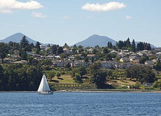
Ladysmith, originally Oyster Harbour, is a town located on the 49th parallel north on the east coast of Vancouver Island, British Columbia, Canada. The local economy is based on forestry, tourism, and agriculture. A hillside location adjacent to a sheltered harbour forms the natural geography of the community.
Sparwood is a district municipality in the Canadian province of British Columbia. It is the second-largest community on the Elk River.
Salmon Arm is a city in the Columbia Shuswap Regional District of the Southern Interior of the Canadian province of British Columbia that has a population of 17,706 (2016). Salmon Arm was incorporated as a municipal district on May 15, 1905. The city of Salmon Arm separated from the district in 1912, but was downgraded to a village in 1958. In 1970, the city of Salmon Arm once again reunited with the District Municipality. Salmon Arm once again became a city in 2005, and is now the location of the head offices of the Columbia-Shuswap Regional District. It is a tourist town in the summer, with many beaches, camping facilities and house boat rentals. Salmon Arm is home to the longest wooden freshwater wharf in North America.
Merritt is a city in the Nicola Valley of the south-central Interior of British Columbia, Canada. It is 270 km (170 mi) northeast of Vancouver. Situated at the confluence of the Nicola and Coldwater rivers, it is the first major community encountered after travelling along Phase One of the Coquihalla Highway and acts as the gateway to all other major highways to the B.C. Interior. The city developed in 1893 when part of the ranches owned by William Voght, Jesus Garcia, and John Charters were surveyed for a town site.
Kootenay—Columbia is a federal electoral district in British Columbia, Canada, that has been represented in the House of Commons of Canada since 1997.
Oliver is a town near the south end of the Okanagan Valley in the Southern Interior of British Columbia, Canada, with a population of nearly 5,000 people. It is located along the Okanagan River by Tuc-el-nuit Lake between Osoyoos and Okanagan Falls, and is labelled as the Wine Capital of Canada by Tourism British Columbia. It was once "The Home of the Cantaloupe" as well as the "Home of the International Horseshow."
Summerland is a district municipality on the west side of Okanagan Lake in the interior of British Columbia, Canada. The district is between Peachland to the north and Penticton to the south. The largest centre in the region is Kelowna, approximately 50 km (31 mi) to the north, and Vancouver is approximately 425 km (264 mi) away to the west. The district is famous for "Bottleneck drive", a system of roads connecting various wineries.
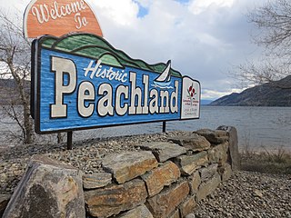
Peachland is a district municipality in the Okanagan Valley on the west side of Okanagan Lake in British Columbia, Canada. It was founded in 1899 by John Moore Robinson, although the region had long been home to the Okanagan people. Peachland is approximately half-an-hour's drive south of the city of Kelowna and about a 20-minute drive north of Summerland. The Okanagan Valley is very narrow in the area and there are few terraces that mark former lake levels and the former lake bottom. As a result, the city is largely located on a steep sidehill. Like many other areas in the Okanagan, Peachland is rapidly growing, with new residents coming from all across Canada. Across the lake from Peachland is Rattlesnake Island, home of the legendary Ogopogo. Peachland is approximately 370 km from Vancouver, British Columbia, on the British Columbia south coast.
The Regional District of Central Okanagan (RDCO) is a regional district in the Canadian province of British Columbia, representing two unincorporated Electoral Areas of Central Okanagan East and Central Okanagan West, along with the member municipalities of the City of Kelowna, City of West Kelowna, the District of Lake Country, the District of Peachland, and Westbank First Nation. The RDCO office is located in Kelowna.
North Okanagan—Shuswap is a federal electoral district in the province of British Columbia, Canada, that has been represented in the House of Commons of Canada since 1988. The district has been sporadically known as Okanagan—Shuswap.
The City of Enderby is in the North Okanagan region of the Canadian province of British Columbia, between Armstrong and Salmon Arm. It is approximately 80 km north of Kelowna and 130 km east of Kamloops. Highway 97A passes through Enderby and the Shuswap River marks the eastern and northeastern limits of the City. There are two major schools in Enderby: M.V. Beattie Elementary School and A.L. Fortune Secondary School. M.V. Beattie Elementary School was rebuilt in 2012.
Vanderhoof is a district municipality near the geographical centre of British Columbia, Canada. Covering 2.92 square kilometers, it has a population of about 4,500 within town limits, and offers services to nearly 10,000 people in nearby rural communities. Its main industries are forestry, agriculture, and related businesses. Tourism is also growing, and mining operations are being developed in the area. It has many elementary schools, and one major secondary school, Nechako Valley Secondary School (NVSS), comprising School District 91 Nechako Lakes. The College of New Caledonia has a regional campus there.
Lake Country is a district municipality with a population of approximately 15,000 in the Okanagan Valley region of British Columbia, Canada. It is a part of the Central Okanagan Regional District, and of the Kelowna metropolitan area. The city of Kelowna lies to the south, while the city of Vernon lies to the north. As its name suggests, there are a number of lakes in the vicinity of Lake Country, and outside the municipal boundaries in the hills to the east. Okanagan Lake defines the western boundary of the municipality, while the entirety of Wood Lake and the southernmost portion of Kalamalka Lake are encompassed by it.
Grand Forks is a city in the Boundary Country of the West Kootenay region of British Columbia, Canada. It is located at the confluence of the Granby and Kettle Rivers, a tributary of the Columbia River. The city is just north of the Canada–United States border, approximately 500 km (310 mi) from Vancouver and 200 km (120 mi) from Kelowna and 23 km (14 mi) west of the resort area of Christina Lake by road.
The Regional District of North Okanagan (RDNO) is a regional district in the Canadian province of British Columbia, Canada. The Canada 2011 Census population was 81,237. The land area is 7,512.58 km2. The regional district's head office is in the district municipality of Coldstream, although the largest population centre is its immediate neighbour, the city of Vernon.
The Regional District of Okanagan-Similkameen (RDOS) is in southern British Columbia, adjacent to the U.S. state of Washington. It is bounded by Fraser Valley Regional District to the west, Thompson-Nicola Regional District and Regional District of Central Okanagan to the north, Regional District of Kootenay Boundary to the east, and by Okanogan County, Washington to the south. At the 2011 census the population was 80,742. The district covers a land area of 10,413.44 square kilometres (4,020.65 sq mi). The administrative offices are in the City of Penticton.
The Regional District of Fraser–Fort George (RDFFG) is a regional district located in the Central Interior of British Columbia, Canada. It is bounded by the Alberta border to the east, the Columbia–Shuswap and Thompson–Nicola regional districts to the south and southeast, Cariboo Regional District to the southwest, the Regional District of Bulkley–Nechako to the west, and the Peace River Regional District to the north and northeast. As of the Canada 2011 Census, Fraser–Fort George had a population of 91,879 and a land area of 51,083.73 km2. The offices of the regional district are located at Prince George.
Coldstream is a district municipality in British Columbia, Canada, located at the northern end of Kalamalka Lake in the Okanagan Valley. Incorporated on December 21, 1906, Coldstream celebrated its centennial in 2006. The municipality is directly southeast of Vernon and is considered part of Greater Vernon. It is a member municipality of, and also the location of the head offices, of the Regional District of North Okanagan.
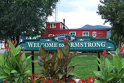
Spallumcheen is a district municipality in the Canadian province of British Columbia. Located in the Okanagan region between Vernon and Enderby, the township had a population of 5,055 and land area of 255.77 square kilometres (98.75 sq mi) in the Canada 2011 Census. The district, whose official name is the Township of Spallumcheen and which is the oldest rural municipality in the British Columbia Interior, consists primarily of agricultural land surrounding the separately incorporated City of Armstrong. Both Spallumcheen and Armstrong are member municipalities of the Regional District of North Okanagan.
West Kelowna, formerly known as Westside and colloquially known as Westbank, is a city in British Columbia's Okanagan Valley on the west shore of Okanagan Lake. The city encompasses several neighbourhoods, including Casa Loma, Gellatly, Glenrosa, Lakeview Heights, Shannon Lake, Smith Creek, Rose Valley, Westbank, and West Kelowna Estates. As of 2021, West Kelowna had an estimated population of 36,078.