
Lock Haven is the county seat of Clinton County, in the U.S. state of Pennsylvania. Located near the confluence of the West Branch Susquehanna River and Bald Eagle Creek, it is the principal city of the Lock Haven Micropolitan Statistical Area, itself part of the Williamsport–Lock Haven combined statistical area. At the 2020 census, Lock Haven's population was 8,108.
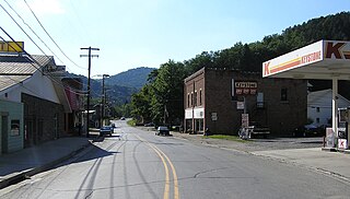
Austin is a borough along the Freeman Run (river) in southwestern Potter County, Pennsylvania, United States. The population was 482 at the 2020 census.

Saint Anthony Falls, or the Falls of Saint Anthony, located at the northeastern edge of downtown Minneapolis, Minnesota, is the only natural major waterfall on the Mississippi River. Throughout the mid-to-late 1800s, various dams were built atop the east and west faces of the falls to support the milling industry that spurred the growth of the city of Minneapolis. In 1880, the central face of the falls was reinforced with a sloping timber apron to stop the upstream erosion of the falls. In the 1950s, the apron was rebuilt with concrete, which makes up the most visible portion of the falls today. A series of locks were constructed in the 1950s and 1960s to extend navigation to points upstream.

The St. Francis Dam, or the San Francisquito Dam, was a concrete gravity dam located in San Francisquito Canyon in northern Los Angeles County, California, United States, that was built between 1924 and 1926. The dam failed catastrophically in 1928, killing at least 431 people in the subsequent flood, in what is considered to have been one of the worst American civil engineering disasters of the 20th century and the third-greatest loss of life in California history.

The Johnstown Flood, sometimes referred to locally as Great Flood of 1889, occurred on Friday, May 31, 1889, after the catastrophic failure of the South Fork Dam, located on the south fork of the Little Conemaugh River, 14 miles (23 km) upstream of the town of Johnstown, Pennsylvania, United States. The dam ruptured after several days of extremely heavy rainfall, releasing 14.55 million cubic meters of water. With a volumetric flow rate that temporarily equaled the average flow rate of the Mississippi River, the flood killed 2,208 people and accounted for US$17,000,000 in damage.

James Bicheno Francis was a British-American civil engineer, who invented the Francis turbine.

The South Fork Fishing and Hunting Club was a Pennsylvania corporation that operated an exclusive and secretive retreat at a mountain lake near South Fork, Pennsylvania, for more than 50 extremely wealthy men and their families.
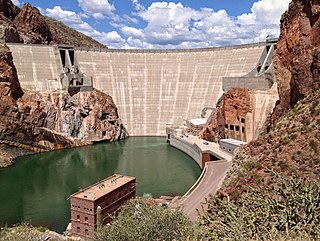
Theodore Roosevelt Dam is a dam on the Salt River located northeast of Phoenix, Arizona. The dam is 357 feet (109 m) high and forms Theodore Roosevelt Lake as it impounds the Salt River. Built between 1905 and 1911, the dam was renovated and expanded in 1989–1996. The dam is named after President Theodore Roosevelt. Serving mainly for irrigation, water supply, and flood control, the dam also has a hydroelectric generating capacity of 36 megawatts.

An embankment dam is a large artificial dam. It is typically created by the placement and compaction of a complex semi-plastic mound of various compositions of soil or rock. It has a semi-pervious waterproof natural covering for its surface and a dense, impervious core. This makes the dam impervious to surface or seepage erosion. Such a dam is composed of fragmented independent material particles. The friction and interaction of particles binds the particles together into a stable mass rather than by the use of a cementing substance.
Floods in the United States before 1900 is a list of flood events that were of significant impact to the country, before 1900. Floods are generally caused by excessive rainfall, excessive snowmelt, and dam failure.

The Lamar Boulevard Bridge is a historic arch bridge carrying Texas State Highway Loop 343 over Lady Bird Lake in downtown Austin, Texas, United States. The bridge features six open-spandrel concrete arches spanning 659 feet (201 m) and carries tens of thousands of vehicles daily across the lake. Completed in 1942, the Lamar Boulevard Bridge was the second permanent bridge to cross the Colorado River, and one of the last Art Deco-style open-spandrel concrete arch bridges built in Texas. The bridge was named an Austin Landmark in 1993 and added to the National Register of Historic Places in 1994.

Auburn Dam was a proposed concrete arch dam on the North Fork of the American River east of the town of Auburn, California, in the United States, on the border of Placer and El Dorado Counties. Slated to be completed in the 1970s by the U.S. Bureau of Reclamation, it would have been the tallest concrete dam in California and one of the tallest in the United States, at a height of 680 feet (210 m) and storing 2,300,000 acre-feet (2.8 km3) of water. Straddling a gorge downstream of the confluence of the North and Middle Forks of the American River and upstream of Folsom Lake, it would have regulated water flow and provided flood control in the American River basin as part of Reclamation's immense Central Valley Project.

The Eastman tunnel, also called the Hennepin Island tunnel, was a 2,000-foot-long (610 m) underground passage in Saint Anthony, Minnesota, dug beneath the Mississippi River riverbed between 1868 and 1869 to create a tailrace so water-powered business could be located upstream of Saint Anthony Falls on Nicollet Island. The tunnel ran downstream from Nicollet Island, beneath Hennepin Island, and exited below Saint Anthony Falls.

The Gillespie Dam is a concrete gravity dam located on the Gila River between the towns of Buckeye and Gila Bend, Arizona. The dam was constructed during the 1920s for primarily irrigation purposes. It was key to the development of a 72,000-acre (29,000 ha) parcel owned by "millionaire" W.S. Gillespie of Tulsa, Oklahoma, initially allowing for irrigation of 10,000 acres (4,000 ha). A portion of the dam failed unexpectedly in 1993 during unusually heavy rains.

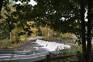
Ascutney Mill Dam, also known as the Windsor Upper Dam and the Mill Pond Dam, is an arch-gravity dam which is one of the oldest and among the earliest storage dams in the United States. It is made of cut granite and is located in Windsor, Vermont in Windsor County near the Connecticut River, where it functioned as a source of hydropower and, later, hydroelectric power. It is on the ASCE list of historic civil engineering landmarks since 1970 and is listed on the National Register of Historic Places since January 09, 2007.
Boone Dam is a hydroelectric and flood control dam on the South Fork Holston River on the border between Sullivan County and Washington County in the U.S. state of Tennessee. It is one of three dams on the South Fork Holston owned and operated by the Tennessee Valley Authority, which built the dam in the early 1950s as part of greater efforts to control flooding in the Tennessee River watershed. The dam impounds the 4,500-acre (1,800 ha) Boone Lake, and its tailwaters are part of Fort Patrick Henry Lake. The dam and associated infrastructure were listed on the National Register of Historic Places in 2017.

The Occum Hydroelectric Plant and Dam is a historic hydroelectric plant and dam north of Bridge Street on the west side of the Shetucket River in Norwich, Connecticut. The facility includes a rare surviving partial example of a large-scale dam built for a textile mill in 1865, and an early example of a hydroelectric power generation facility established in 1934. It is one of a small number of surviving hydroelectric plants in the state which was built before 1940. The complex was listed on the National Register of Historic Places in 1996.

The Sweetwater Dam is a dam across the Sweetwater River in San Diego County, California. It is located approximately 12 miles (19 km) east of San Diego, 9 miles (14 km) and borders Bonita to the southwest and La Presa to the northeast. The 108-foot (33 m)-high masonry arch dam impounds 960-acre (390 ha) Sweetwater Reservoir.
The Wiswall Falls Mill Site is a historic archaeological industrial site in Durham, New Hampshire. It is located in John Hatch Park, a small public park just south of Wiswall Road on the eastern bank of the Lamprey River. The 3-acre (1.2 ha) site encompasses the remains of a small 19th-century mill complex that was one of Durham's major industrial sites of the 19th century until it burned in 1883. The site, which includes remains of the waterworks and foundations, was listed on the National Register of Historic Places in 1988.

The Green River Crib Dam is a historic 19th-century dam on the Green River in western Guilford, Vermont. Built about 1811, it is a reminder of the modest industrial enterprises once conducted in the area using the water power it provided, and is one of the state's few surviving crib dams. It was listed on the National Register of Historic Places in 1995.


