Azure Maps

Last updated
Azure Maps
Developer(s) Microsoft
Initial releaseMay 29, 2018;5 years ago (2018-05-29) [1]
Operating system Windows Desktop, Windows Server, Ubuntu, Red Hat Enterprise Linux, CentOS, MacOS, iOS, Android, Docker, Azure virtual machines, container orchestration platforms
Type Location based services, cloud services
License Proprietary, commercial software
Website azure.microsoft.com/en-us/products/azure-maps

Azure Maps is a suite of cloud-based, location-based services provided by Microsoft as part of the company's Azure platform. The platform provides geospatial and location-based services via REST APIs and software development kits (SDKs). The service is typically used to integrate maps or geospatial data into applications.

Contents

Azure Maps differs from Microsoft's other enterprise mapping service, Bing Maps, in its pricing model, focus on privacy, and its level of integration into the broader Azure cloud ecosystem. [2] [3]

History

Azure Maps was first introduced in public preview mode under the name "Azure Location Based Services" in 2017, primarily as an enterprise solution. [4] The services was intended to add mapping and location-based functionality onto the existing Azure cloud services suite, seen as a critical part of Microsoft's broader Internet-of-Things (IoT) strategy. [5]

The preview version included APIs which could be used to develop location aware apps for use cases such as logistics and mobility. In 2018, the software was renamed "Azure Maps," and became generally available to the public, and a number of new functions were added, including route calculation, travel time calculation, and incorporation of real-time traffic data and incident information. [6]

Azure Maps was integrated with Azure IoT Central in 2018, which added tracking, monitoring, and geofencing capabilities. [7] A set of mobility APIs on were added in 2019, with applications such as use in public transport apps and shared bicycle fleet management. [8] “Azure Maps Creator,” which converts private facility floor plans into indoor map data, was also introduced in 2019. [9] Some commentators linked these services to Microsoft's broader development of augmented reality products. [10] [11]

In 2020, Azure Maps Visual for Power BI was released, integrating location-based features and mapping capabilities into Microsoft's business intelligence software. [12]

An elevation API (which was later retired), [13] geolocation services, [14] and an iOS [15] and Android software development kit [16] were introduced in 2021.

In 2022, support for historical weather, air quality, and tropical storm data was made generally available and custom styling for indoor maps was also introduced. [17] In 2023, Azure Maps was certified as HIPAA compliant in a move to target healthcare and health insurance companies. [18]

Functionality

Geocoding

Geocoding is one of the core functionalities of Azure Maps, converting addresses or place names into geographic coordinates. Batch geocoding is used to process large amounts of address data, a function used for route optimization and spatial analysis. [19]

Reverse geocoding

Reverse geocoding derives human-readable information from geographic coordinates like longitude and latitude, used in navigation and by geographic information systems. [20]

Routing

Azure Maps uses map data and routing algorithms to calculate the shortest or fastest routes between locations based on factors like vehicle size and type, traffic conditions, and distance. [21] Routing also supports multi-modal routing, which include multiple modes of transport in a single trip, including cycling, walking, and ferries.

This functionality is used for location-based searches and route optimization in applications like fleet management, [22] proximity marketing, [23] and emergency services [24] as well as logistics and delivery, urban planning, ride sharing apps, and outdoor activities. [25]

Map visualization

The platform supports map visualizations that can be modified to reflect real-time data (including from IoT sensors) as well as historical data patterns. Visualizations include heat maps, street maps, satellite imagery and other custom data layers. [26] Maps are rendered using raster or vector tiles which reduce the load of displaying large data sets or complex maps. [27]

This can be used in various applications in areas like transportation, smart cities, retail and marketing, public health, and environmental monitoring. For example, it can be used for tracking the spread of diseases [28] or measuring the impact of changing climatic patterns. [29]

Geofencing and spatial analytics

Azure Maps supports polygonal geofencing, which enables the definition of custom geographic boundaries. Geofenced areas can be monitored in real-time for events of interest. For example, an application could send an alert when equipment or persons enter or leave a defined area. [30]

Tools for analyzing historical geofencing data are also available via the APIs for optimization purposes. [31]

Industry usage

Azure Maps' geofencing function has seen usage in the construction industry, designating hazardous areas for safety purposes and sending alerts if anyone enters the area. [32] Private facility maps are used by construction companies for monitoring large construction sites to increase productivity and prevent accidents or damage. [33]

In emergency management, New Zealand based company Beca has used Azure Maps to provide analysis on the impact of earthquakes to users, including information on the severity and location of an earthquake and the impact on affected properties. [34] Alaska's Department of Transportation uses Azure Maps as part of an information system providing weather-related warnings and analytics to road crews. [35]

Airmap, an airspace management platform for drones, uses Azure Maps. [36]

Azure Maps has also been used in conjunction with Azure Monitor for risk monitoring by an insurance company. [37]

Other companies that use or have used Azure Maps include BMW, Banco Santander, Jvion, MV Transportation, C.H. Robertson, Wise Skulls, Tata Consultancy Services, Providence Health and Services, Gas Brasiliano Distribuidora S.A., Shell plc, Persistent Systems, Phase 2 Dining and Entertainment, Symbio, HID, Globant, and Insight Enterprises. [38] [39]

Partnerships

Azure Maps and TomTom have been partners since 2016, [40] [41] and TomTom provides location data to Azure Maps and can process data from Azure Maps for mapping purposes. [42] [43]

In 2021, Azure Maps partnered with AccuWeather to make climatic data available via its APIs, making weather data along all parts of calculated routes available for mobility and logistics purposes. [44]

Microsoft has partnered with Esri, the developer of ArcGIS, [5] and there is cross-compatibility between Azure and ArcGIS so that data from Azure Maps can be integrated into ArcGIS and vice versa. [45]

Azure Maps partnered with Moovit in 2019, a startup providing software that interfaces with public transport data. [46] Moovit's database on global public transit networks, including information on which stations and facilities are wheelchair accessible, was linked to Azure Maps. This service was noted for its use increasing accessibility to public transport for the visually impaired by means of voice activated route planning assistance. [47]

NORAD has used some Azure Maps functions for their NORAD Tracks Santa website during Christmas holidays. [48]

Components

REST APIs

Various APIs cover the major functionalities across Azure Maps:

SDKs

Azure Maps SDKs uses MapLibre-style specifications and open source MapLibre GL-based libraries as a rendering engine. [58] The Web SDK is used for developing web apps with maps and location-based data and functionality. It includes a map control module [59] as well as modules with drawing tools. It also supports Azure Maps Creator and various spatial data formats. [60]

The platform also includes a set of REST SDKs for developers integrating Azure Maps REST APIs into Python, C#, Java or JavaScript applications. [61]

Azure Maps also includes Android and iOS SDKs used for developing applications for Android and Apple devices. [62]

Azure Maps Creator

Azure Maps Creator is a tool for generating custom maps for locations like large office complexes, construction sites, or university campuses. These maps can then be integrated into applications and used with other Azure Maps functions for purposes such as wayfinding and maintenance and security in building automation contexts. [63]

Azure Maps Visual for Power BI

Azure Maps is integrated with Microsoft Power BI, a graphical tool for producing data visualizations. Since July 2020, Power BI can be used in conjunction with Azure Maps for developing map-based data visualizations. [64] This functionality entered general availability in May 2023. [65]

See also

Related Research Articles

Microsoft Configuration Manager (ConfigMgr) is a systems management software product developed by Microsoft for managing large groups of computers providing remote control, patch management, software distribution, operating system deployment, and hardware and software inventory. Configuration Manager supports the Microsoft Windows and Windows Embedded operating systems. Previous versions also supported macOS (OS X), Linux or UNIX, as well as Windows Phone, Symbian, iOS and Android mobile operating systems.

<span class="mw-page-title-main">NASA WorldWind</span> Open-source virtual globe

NASA WorldWind is an open-source virtual globe. According to the website, "WorldWind is an open source virtual globe API. WorldWind allows developers to quickly and easily create interactive visualizations of 3D globe, map and geographical information. Organizations around the world use WorldWind to monitor weather patterns, visualize cities and terrain, track vehicle movement, analyze geospatial data and educate humanity about the Earth." It was first developed by NASA in 2003 for use on personal computers and then further developed in concert with the open source community since 2004. As of 2017, a web-based version of WorldWind is available online. An Android version is also available.

A gateway is a piece of networking hardware or software used in telecommunications networks that allows data to flow from one discrete network to another. Gateways are distinct from routers or switches in that they communicate using more than one protocol to connect multiple networks and can operate at any of the seven layers of the OSI model.

Windows Server is a group of server operating systems (OS) that has been developed by Microsoft since 1993. The first OS that was released for this platform is Windows NT 3.1 Advanced Server, an edition of Windows NT 3.1. With the release of Windows Server 2003, Microsoft started releasing new versions under the name Windows Server. The latest release of Windows Server is Windows Server 2022, which was released in 2021.

A GIS software program is a computer program to support the use of a geographic information system, providing the ability to create, store, manage, query, analyze, and visualize geographic data, that is, data representing phenomena for which location is important. The GIS software industry encompasses a broad range of commercial and open-source products that provide some or all of these capabilities within various information technology architectures.

<span class="mw-page-title-main">Bing Maps</span> Web mapping service from Microsoft

Bing Maps is a web mapping service provided as a part of Microsoft's Bing suite of search engines and powered by the Bing Maps Platform framework which also support Bing Maps for Enterprise APIs and Azure Maps APIs. Since 2020, the map data is provided by TomTom, OpenStreetMap and others.

ArcGIS Server is the core server geographic information system (GIS) software made by Esri. ArcGIS Server is used for creating and managing GIS Web services, applications, and data. ArcGIS Server is typically deployed on-premises within the organization’s service-oriented architecture (SOA) or off-premises in a cloud computing environment.

<span class="mw-page-title-main">Microsoft Azure SQL Database</span> Managed cloud database

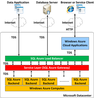
Microsoft Azure SQL Database is a managed cloud database (PaaS) cloud-based Microsoft SQL Servers, provided as part of Microsoft Azure services. The service handles database management functions for cloud based Microsoft SQL Servers including upgrading, patching, backups, and monitoring without user involvement.

<span class="mw-page-title-main">Here Technologies</span> Netherlands-based mapping data company

Here Technologies is a Dutch multinational group specialized in mapping technologies, location data and related automotive services to individuals and companies. It is majority-owned by a consortium of German automotive companies and American semiconductor company Intel whilst other companies also own minority stakes. Its roots date back to U.S.-based Navteq in 1985, which was acquired by Finland-based Nokia in 2007. Here is currently based in The Netherlands.

<span class="mw-page-title-main">Microsoft Azure</span> Cloud computing platform by Microsoft

Microsoft Azure, often referred to as Azure, is a cloud computing platform run by Microsoft. It offers access, management, and the development of applications and services through global data centers. It also provides a range of capabilities, including software as a service (SaaS), platform as a service (PaaS), and infrastructure as a service (IaaS). Microsoft Azure supports many programming languages, tools, and frameworks, including Microsoft-specific and third-party software and systems.

<span class="mw-page-title-main">Bing Maps Platform</span> Geospatial mapping platform by Microsoft

Bing Maps Platform is a geospatial mapping platform produced by Microsoft. It allows developers to create applications that layer location-relevant data on top of licensed map imagery. The imagery includes samples taken by satellite sensors, aerial cameras, Streetside imagery, 3D city models and terrain.

Backend as a service (BaaS), sometimes also referred to as mobile backend as a service (MBaaS), is a service for providing web app and mobile app developers with a way to easily build a backend to their frontend applications. Features available include user management, push notifications, and integration with social networking services. These services are provided via the use of custom software development kits (SDKs) and application programming interfaces (APIs). BaaS is a relatively recent development in cloud computing, with most BaaS startups dating from 2011 or later. Some of the most popular service providers are AWS Amplify and Firebase.

Moovit is an Israel-based mobility as a service provider and journey planner app. It is owned by Mobileye, and was acquired by Intel in 2020 until Mobileye's IPO in 2022. Moovit uses both crowdsourced and official public transit data to provide route planning to users as well as transit data APIs to transit companies, cities, and transit agencies. Because Moovit integrates crowdsourced data, it can provide transit information for areas where no data is officially available.

Google Cloud Platform (GCP), offered by Google, is a suite of cloud computing services that provides a series of modular cloud services including computing, data storage, data analytics, and machine learning, alongside a set of management tools. It runs on the same infrastructure that Google uses internally for its end-user products, such as Google Search, Gmail, and Google Docs, according to Verma, et.al. Registration requires a credit card or bank account details.

Kubernetes is an open-source container orchestration system for automating software deployment, scaling, and management. Originally designed by Google, the project is now maintained by a worldwide community of contributors, and the trademark is held by the Cloud Native Computing Foundation.

Azure Cosmos DB is a globally distributed, multi-model database service and offered by Microsoft. It is designed to provide high availability, scalability, and low-latency access to data for modern applications. Unlike traditional relational databases, Cosmos DB is a NoSQL and vector database, which means it can handle unstructured, semi-structured, structured, and vector data types.

Microsoft Azure Cognitive Search, formerly known as Azure Search, is a component of the Microsoft Azure Cloud Platform providing indexing and querying capabilities for data uploaded to Microsoft servers. The Search as a service framework is intended to provide developers with complex search capabilities for mobile and web development while hiding infrastructure requirements and search algorithm complexities. Azure Search is a recent addition to Microsoft's Infrastructure as a Service (IaaS) approach.

<span class="mw-page-title-main">Azure Sphere</span> Linux-based microcontroller system

Azure Sphere is an application platform with integrated communications and security features developed and managed by Microsoft for Internet Connected Devices.

<span class="mw-page-title-main">Windows App SDK</span> Software development kit from Microsoft

Windows App SDK is a software development kit (SDK) from Microsoft that provides a unified set of APIs and components that can be used to develop desktop applications for both Windows 11 and Windows 10 version 1809 and later. The purpose of this project is to offer a decoupled implementation of capabilities which were previously tightly-coupled to the UWP app model. Windows App SDK allows native Win32 (USER32/GDI32) or .NET (WPF/WinForms) developers alike a path forward to enhance their apps with modern features.

References

  1. "General availability: Azure Maps | Azure updates | Microsoft Azure". azure.microsoft.com. Retrieved 2024-03-27.
  2. Bisson, Simon (2019-03-05). "How Azure Maps differs from Bing Maps for developers". InfoWorld. Retrieved 2024-03-27.
  3. Chia, Snake (2018-08-02). "Azure Maps vs Bing Maps". Medium. Retrieved 2024-03-27.
  4. IANS (2017-11-30). "Microsoft launches 'Azure Location Based Services' Public Preview". The Statesman. Retrieved 2024-03-10.
  5. 1 2 Corp, Microsoft. "Microsoft launches Azure Location Based Services for geospatial needs across industries". www.prnewswire.com. Retrieved 2024-03-10.
  6. "Azure Maps unveils satellite imagery, batch services, and advanced geospatial functionality | Azure updates | Microsoft Azure". azure.microsoft.com. Retrieved 2024-03-10.
  7. "New in Azure Maps: API, map control modules, imagery, and styling features | Azure updates | Microsoft Azure". azure.microsoft.com. Retrieved 2024-03-10.
  8. Nyman, Outi (2019-06-07). "Announcing Mobility service for Azure Maps, SDKs updates, and more". Microsoft Azure Blog. Retrieved 2024-03-10.
  9. dev-admin (2023-05-30). "Indoor Mapping | Start For Free | Microsoft Azure Maps". www.microsoft.com. Retrieved 2024-03-10.
  10. "Meet Facebook's metaverse competitors". Quartz. 2021-11-01. Retrieved 2024-03-10.
  11. "Microsoft previews Azure Maps Creator to enable indoor location apps and AR". SiliconANGLE. 2020-06-01. Retrieved 2024-03-10.
  12. Brundritt, Ricky (2020-07-13). "Azure Maps Power BI visual now in preview". Microsoft Azure Blog. Retrieved 2024-03-27.
  13. matrix (2021-06-17). "Azure Maps Elevation Service API". Grey Matter. Retrieved 2024-03-27.
  14. "Azure Maps Geolocation Service is now generally available | Azure updates | Microsoft Azure". azure.microsoft.com. Retrieved 2024-03-27.
  15. "Azure Maps iOS SDK is now in public preview | Azure updates | Microsoft Azure". azure.microsoft.com. Retrieved 2024-03-27.
  16. Wiggers, Kyle (2019-02-11). "Microsoft introduces Azure Maps Android SDK in preview, new Azure Maps services". VentureBeat. Retrieved 2024-03-27.
  17. "Azure Updates: IoT adoption; GPU monitoring; Maps Weather Services; Open Source Day". MSDynamicsWorld.com. Retrieved 2024-03-27.
  18. "Azure Maps is now HIPAA (Health Insurance Portability and Accountability Act) compliant | Azure updates | Microsoft Azure". azure.microsoft.com. Retrieved 2024-03-27.
  19. eriklindeman (2023-08-18). "Geocoding coverage in Microsoft Azure Maps Search service - Microsoft Azure Maps". learn.microsoft.com. Retrieved 2024-03-10.
  20. eriklindeman (2023-04-24). "Search for a location using Azure Maps Search services". learn.microsoft.com. Retrieved 2024-03-26.
  21. sinnypan (2023-07-27). "Tutorial: How to display route directions using Azure Maps Route service and Map control - Microsoft Azure Maps". learn.microsoft.com. Retrieved 2024-03-26.
  22. "Exploring Fleet Management Scenarios with Azure Maps". TECHCOMMUNITY.MICROSOFT.COM. Retrieved 2024-03-26.
  23. jodahlMSFT (2024-01-20). "Enrich customer profiles with location data from Azure Maps (preview) - Dynamics 365 Customer Insights". learn.microsoft.com. Retrieved 2024-03-26.
  24. Seto, Julie (2018-11-29). "Using AI and IoT for disaster management". Microsoft Azure Blog. Retrieved 2024-03-26.
  25. eriklindeman (2024-01-23). "Routing coverage - Microsoft Azure Maps". learn.microsoft.com. Retrieved 2024-03-26.
  26. sinnypan (2023-06-26). "Create a data source for a map in Microsoft Azure Maps". learn.microsoft.com. Retrieved 2024-03-10.
  27. "Public preview: New Azure Maps Creator feature - custom styling | Azure updates | Microsoft Azure". azure.microsoft.com. Retrieved 2024-03-10.
  28. "Did you know Azure Maps is HIPAA compliant?". TECHCOMMUNITY.MICROSOFT.COM. Retrieved 2024-03-26.
  29. "General availability: New Azure Maps features historical weather, air quality, and tropical storms | Azure updates | Microsoft Azure". azure.microsoft.com. Retrieved 2024-03-26.
  30. markdefalco (2020-01-13). "Geofencing with Azure Maps". learn.microsoft.com. Retrieved 2024-03-26.
  31. codemillmatt (2022-03-04). "Geospatial APIs to add maps, spatial analytics, and mobility solutions with Azure Maps". learn.microsoft.com. Retrieved 2024-03-26.
  32. Wiggers, Kyle (2019-02-11). "Microsoft introduces Azure Maps Android SDK in preview, new Azure Maps services". VentureBeat. Retrieved 2024-03-26.
  33. "PCL Construction uses IoT with Azure to revolutionize the construction industry". Microsoft Customers Stories. Retrieved 2024-03-26.
  34. "Beca uses Microsoft Azure to help earthquake-struck communities". Technology Record | The best of enterprise solutions from the Microsoft partner ecosystem. Retrieved 2024-03-26.
  35. "Microsoft launches public preview of Azure Location Based Services with TomTom". ZDNET. Retrieved 2024-03-26.
  36. Lucchi, Roberto (2019-01-17). "Dynamic mission planning for drones with Azure Maps | Azure Blog | Microsoft Azure". Azure Blog (in European Spanish). Retrieved 2024-03-26.
  37. "Nordic insurer guarantees DevOps quality with cloud-based monitoring and governance". Microsoft Customers Stories. Retrieved 2024-03-26.
  38. "Companies Using Azure Maps, Market Share, Customers and Competitors". discovery.hgdata.com. Retrieved 2024-03-26.
  39. "Azure Maps commands 0.01% market share in Web Mapping". enlyft.com. Retrieved 2024-03-26.
  40. Chan, Rosalie. "Dutch mapping company TomTom explains why it's betting on Microsoft's cloud". Business Insider. Retrieved 2024-03-26.
  41. "TomTom's navigation technology is now part of Microsoft's Connected Vehicle Platform". ZDNET. Retrieved 2024-03-26.
  42. "Microsoft begins Bing and Azure Maps migration to TomTom - OnMSFT.com". 2020-06-01. Retrieved 2024-03-26.
  43. eriklindeman (2023-09-25). "Overview for Microsoft Azure Maps". learn.microsoft.com. Retrieved 2024-03-26.
  44. "Microsoft and AccuWeather partner for new Azure Maps capabilities". Technology Record | The best of enterprise solutions from the Microsoft partner ecosystem. Retrieved 2024-03-26.
  45. "Using Azure Maps in ArcGIS and QGIS". TECHCOMMUNITY.MICROSOFT.COM. Retrieved 2024-03-26.
  46. O'Brien, Chris (2018-11-06). "Moovit partners with Microsoft to provide public transit data for Azure Maps". VentureBeat. Retrieved 2024-03-26.
  47. Sawers, Paul (2019-11-19). "Aira, Microsoft, and Moovit make public transport more accessible for the visually impaired". VentureBeat. Retrieved 2024-03-26.
  48. "HO HO HO Two Point OH!". TECHCOMMUNITY.MICROSOFT.COM. Retrieved 2024-03-26.
  49. markjulmar. "Data Registry - REST API (Azure Maps)". learn.microsoft.com. Retrieved 2024-03-12.
  50. markjulmar. "Geolocation - REST API (Azure Maps)". learn.microsoft.com. Retrieved 2024-03-12.
  51. markjulmar. "Render - REST API (Azure Maps)". learn.microsoft.com. Retrieved 2024-03-12.
  52. markjulmar. "Route - REST API (Azure Maps)". learn.microsoft.com. Retrieved 2024-03-12.
  53. markjulmar. "Search - REST API (Azure Maps)". learn.microsoft.com. Retrieved 2024-03-12.
  54. markjulmar. "Spatial - REST API (Azure Maps)". learn.microsoft.com. Retrieved 2024-03-12.
  55. markjulmar. "Timezone - REST API (Azure Maps)". learn.microsoft.com. Retrieved 2024-03-12.
  56. markjulmar. "Traffic - REST API (Azure Maps)". learn.microsoft.com. Retrieved 2024-03-12.
  57. markjulmar. "Weather - REST API (Azure Maps)". learn.microsoft.com. Retrieved 2024-03-12.
  58. sinnypan (2024-02-22). "Release notes - Map Control - Microsoft Azure Maps". learn.microsoft.com. Retrieved 2024-03-27.
  59. sinnypan (2023-10-12). "How to use the Azure Maps web map control - Microsoft Azure Maps". learn.microsoft.com. Retrieved 2024-03-27.
  60. eriklindeman (2023-10-12). "How to use the Azure Maps spatial IO module - Microsoft Azure Maps". learn.microsoft.com. Retrieved 2024-03-27.
  61. sinnypan (2023-03-30). "REST SDK Developer Guide - Azure Maps". learn.microsoft.com. Retrieved 2024-03-27.
  62. eriklindeman (2023-09-25). "Overview for Microsoft Azure Maps". learn.microsoft.com. Retrieved 2024-03-27.
  63. dev-admin (2023-05-30). "Indoor Mapping | Start For Free | Microsoft Azure Maps". www.microsoft.com. Retrieved 2024-03-27.
  64. deniseatmicrosoft (2023-09-29). "Get started with Azure Maps Power BI visual - Microsoft Azure Maps". learn.microsoft.com. Retrieved 2024-03-27.
  65. "Azure Maps visual for Power BI is now GA". TECHCOMMUNITY.MICROSOFT.COM. Retrieved 2024-03-27.