BMT Astoria Line

Last updated

BMT Astoria Line
NYCS-bull-trans-N-Std.svg NYCS-bull-trans-W-Std.svg
The N and W train services use the entire BMT Astoria Line.
Overview
Owner City of New York
Termini
Stations7
Service
Type Rapid transit
System New York City Subway
Operator(s) New York City Transit Authority
Daily ridership47,522 [1]
History
Opened1917
Technical
Number of tracks2-3
CharacterElevated
Track gauge 4 ft 8+12 in (1,435 mm)
Electrification 600V DC third rail
Route map

Contents

BSicon uhKBHFa.svg
Astoria–Ditmars Boulevard
BSicon hCONTgq.svg
BSicon umhKRZhu.svg
BSicon hCONTfq.svg
BSicon uhHSTACC.svg
Astoria Boulevard
BSicon uhHST.svg
30th Avenue
BSicon uhHST.svg
Broadway
BSicon uhHST.svg
36th Avenue
BSicon uhHST.svg
39th Avenue
BSicon uhSTR.svg
BSicon utdCONTg.svg
BSicon utCONTgq.svg
BSicon uhKRZt.svg
BSicon utSTRq.svg
BSicon utdABZgr.svg
BSicon uhSTR.svg
BSicon uhvSTR+l-.svg
BSicon utKRZh.svg
BSicon uhCONTfq.svg
Flushing Line
to Flushing–Main Street
BSicon lhSTR(r).svg
BSicon uexvUSTx.svg
BSicon uvSTR.svg
BSicon lhSTR(r).svg
BSicon utdACC.svg
BSicon uhv-BHF-L.svg
BSicon uhvBHF-R-.svg
BSicon utSTR.svg
Queensboro Plaza
BSicon uhSTR.svg
BSicon hPORTALf.svg
BSicon uhvSTR2-.svg
BSicon uhSTRc3.svg
BSicon utSTR3.svg
BSicon utdSTRc2.svg
BSicon utdSTR.svg
BSicon uhSTRc1.svg
BSicon utSTR3+1.svg
BSicon uhCONT4.svg
Flushing Line
to 34th Street–Hudson Yards
BSicon utdABZg+1.svg
BSicon POINTER4.svg
BSicon utSTRc4.svg
BSicon utCONTf.svg
Legend

BSicon utBHF.svg
Express station
BSicon utHST.svg
Local station

The BMT Astoria Line (formerly the IRT Astoria Line) is a rapid transit line in the B Division of the New York City Subway, serving the Queens neighborhood of Astoria. It runs south from Ditmars Boulevard in Astoria to 39th Avenue in Long Island City above 31st Street. It then turns west and serves Queensboro Plaza over Queens Plaza.

The entire line is served by the N train at all times, joined by the W train only on weekdays during the day. [2] [3] It was built as part of the Dual Contracts and jointly operated by the Interborough Rapid Transit Company (IRT) and Brooklyn–Manhattan Transit Corporation (BMT) using IRT-sized cars until 1949, when the platforms were shaved to accept the wider BMT cars and joint service was discontinued.

Description and service

All services make all stops on the BMT Astoria Line. [2] [3] [4]

 Time period
WeekdaysLate nights and weekends
NYCS-bull-trans-N-Std.svg full line
NYCS-bull-trans-W-Std.svg full lineno service
Overview of the BMT Astoria Line Linea BMT Astoria.png
Overview of the BMT Astoria Line

The north end of the Astoria Line is a two-track terminal at Ditmars Boulevard, with one island platform. South of the station, the center express track, currently not used in revenue service, begins (with crossovers to allow terminating trains to reach the correct track). The next station, Astoria Boulevard, is the only express station on the three-track section. The next four stations are local ones with two side platforms. [5]

South of 39th Avenue, the express track merges with the two outer tracks. The line then curves west and enters Queensboro Plaza, a dual-level station with northbound trains on the upper level, southbound trains on the lower level, and cross-platform transfers to the IRT Flushing Line. Crossover tracks exist between the upper-level tracks just north of the station, one of a few connections between the BMT / IND and IRT. After Queensboro Plaza, the line ramps underground, and merges with the 60th Street Tunnel Connection to become the BMT Broadway Line via the 60th Street Tunnel to Manhattan. [5]

History

Opening

The BMT Astoria Line was originally served by the IRT "8" train. R12 IRT 8.gif
The BMT Astoria Line was originally served by the IRT "8" train.
A poster describing the changes at Queensborough Plaza in 1949 October 17, 1949 New York Board of Transportation Subway Service Change Poster .jpg
A poster describing the changes at Queensborough Plaza in 1949
Entrance to the 60th Street Tunnel NYCS BMT 60thStTunnel.jpg
Entrance to the 60th Street Tunnel
Passing under New York Connecting Railroad N BMT under NYCR jeh.JPG
Passing under New York Connecting Railroad
Northbound curve on the Astoria line east of Queensboro Plaza station Turning on Astoria Line.JPG
Northbound curve on the Astoria line east of Queensboro Plaza station
Queensboro Plaza station as seen from a southbound Astoria line train Queensboro Plaza Station.jpg
Queensboro Plaza station as seen from a southbound Astoria line train

The Astoria Line was originally part of the IRT, as a spur off the IRT Queensboro Line, now the IRT Flushing Line. The whole line north of Queensboro Plaza opened on February 1, 1917 and was used by trains between Grand Central and Astoria. [6] [7] Through IRT service to the Corona Line (now the Flushing Line) began two months later on April 21. [8]

On July 23, 1917, the Queensboro Bridge spur of the elevated IRT Second Avenue Line opened. At that time, all elevated trains to Queensboro Plaza used the Astoria Line while all subway trains used the Corona Line, though this was later changed with trains alternating between branches. [7] [9]

The 60th Street Tunnel opened on August 1, 1920, allowing BMT trains to reach Queensboro Plaza. However, the stations on the Astoria and Corona Lines were built to IRT specifications, whose platforms were too wide for BMT rolling stock. As a result, those trains terminated at Queensboro Plaza using a relay track east of the station to reverse direction for the return trip to Manhattan. [10]

On April 8, 1923, the BMT, using elevated cars, started running shuttles along the Astoria (numbered BMT 8 in 1924) and Corona Lines ( BMT 9 ) in addition to the existing IRT service. On June 23, 1942, the IRT Second Avenue Line spur to Queensboro Plaza closed. [11]

The IRT services were numbered in 1948, with 7 being assigned to the Flushing Line and 8 to the Astoria Line.

Modifications

On July 24, 1949, through service between the Astoria Line and the IRT Times Square station was discontinued. [12] On October 17, 1949, the Flushing Line became IRT-only. The platforms on the Astoria Line were shaved back to allow through BMT trains to operate on it, the first ones being the Brighton Local (BMT 1) weekdays & Broadway - Fourth Avenue Local (BMT 2) at all times. [13] Since then, the Astoria Line has hosted the northern end of various services running from Brooklyn through Manhattan; see B, N, Q, R, T and W for details.

The platforms at the seven stations on the Astoria Line were lengthened to 610 feet (190 m) to accommodate ten-car (60') trains in 1950. [14] :23 The project cost $863,000. Signals on the line had to be modified to take into account the platform extensions. [15] :633,729

As part of an 18-month capital budget that took effect on January 1, 1963, the wooden platforms at the stations on the Astoria Line were replaced with concrete platforms. [16]

The 2015–2019 MTA Capital Plan called for the Astoria Line's 30th Avenue, Broadway, 36th Avenue, and 39th Avenue stations, along with 29 others, to undergo a complete overhaul as part of the Enhanced Station Initiative. Updates included cellular service, Wi-Fi, USB charging stations, interactive service advisories and maps, improved signage, and improved station lighting. [17] [18] The 30th and 36th Avenues stations were renovated first, from October 2017 to June 2018. After these two stations were reopened, the Broadway and 39th Avenue stations were renovated from July 2018 to January 2019. [19] The remaining stations on the line, Astoria Boulevard and Astoria-Ditmars Boulevard, are also simultaneously undergoing renovations. Astoria-Ditmars Boulevard was renovated from April 2018 to June 2019 and would remain open during this time. However, the Astoria Boulevard station was closed from March 2019 until late 2019. Astoria Boulevard's mezzanine was torn down and replaced, and elevators were added at the station. [19]

Extension proposals

A 1920s Transit Commission study proposed extending the line northwest across or under Randalls and Wards Islands back into Manhattan as a crosstown line at 125th Street, roughly following the route of what is now the Triborough Bridge. [20] As part of the IND Second System plan from 1929, the BMT/IRT Astoria Line would be extended east via Ditmars Boulevard, Astoria Boulevard, 112th Street, and Nassau Boulevard (today's Long Island Expressway) terminating at Cross Island Boulevard. The new line that would have been an extension of the Astoria Line would be called the Long Island City-Horace Harding Boulevard Line. The line would have been 2 tracks to Astoria Boulevard, and afterward, it would become a 4 track line before going back to 2 tracks at Parsons Boulevard. The entire line would be elevated except for a short section which would have been depressed under Nassau Boulevard. The line would have been extended 8.1 miles at a cost of $17.7 million. [21] [22] [23]

In 1998, an extension of the BMT Astoria Line to LaGuardia Airport was planned as part of a $1.2 billion package to provide access to the New York City airports with funding from the MTA, the Port Authority and the city. The preferred route would have extended the Astoria Line along 31st Street north onto Con Edison's property at the edge of Astoria and then east along 19th Avenue to the Marine Air Terminal. The MTA also considered an eastward extension along Ditmars Boulevard, and a plan to reroute LaGuardia-bound trains from Queensboro Plaza through the Sunnyside rail yard and along the eastern edge of St. Michael’s Cemetery to elevated tracks parallel to the Grand Central Parkway. A fourth route was to have trains turn east via Astoria Boulevard. [24] All of the options would have new elevated sections built. $645 million for the LaGuardia extension was included in the MTA's 2000–2004 Five-Year Capital Plan, and in late 2002, Mayor Bloomberg supported the extension. These options were studied in the LaGuardia Airport Subway Access Study. [25] Community opposition was strong and therefore the plan was canceled in July 2003; [26] [27] however, as of 2021, it is being reconsidered after New York governor Kathy Hochul requested the Port Authority find alternatives to the AirTrain LaGuardia project. [28]

The Regional Plan Association, in its Fourth Plan in 2017, anticipated that the population of Astoria would quickly grow over the next three decades, and so called for the Astoria Line to be extended to a new storage yard at Ditmars Boulevard and 20th Street, which would provide added capacity. In addition, a new station at 21st Avenue and 20th Street would improve access for the currently underserved but dense northwest parts of Astoria. [29]

Station listing

Station service legend
NYCS-SSI-alltimes.svg Stops all times
NYCS-SSI-allexceptnights.svg Stops all times except late nights
NYCS-SSI-weekdaysonly.svg Stops weekdays during the day
NYCS-SSI-rushpeak.svg Stops rush hours in the peak direction only
Time period details
Wheelchair symbol.svg Station is compliant with the Americans with Disabilities Act
Wheelchair symbol.svg  Station is compliant with the Americans with Disabilities Act
in the indicated direction only
Wheelchair symbol.svg  
Aiga elevator.svg Elevator access to mezzanine only
Neighborhood
(approximate)
Wheelchair symbol.svg StationTracksServicesOpenedTransfers and notes
Astoria Astoria–Ditmars Boulevard N   NYCS-SSI-alltimes.svg W   NYCS-SSI-weekdaysonly.svg February 1, 1917 [6] originally Ditmars Avenue
Center Express track begins (No Regular Service)
Wheelchair symbol.svg Astoria Boulevard all N   NYCS-SSI-alltimes.svg W   NYCS-SSI-weekdaysonly.svg February 1, 1917 [6] originally Hoyt Avenue
M60 Select Bus Service to LaGuardia Airport
30th Avenue local N   NYCS-SSI-alltimes.svg W   NYCS-SSI-weekdaysonly.svg February 1, 1917 [6] originally Grand Avenue
Broadway local N   NYCS-SSI-alltimes.svg W   NYCS-SSI-weekdaysonly.svg February 1, 1917 [6]
36th Avenue local N   NYCS-SSI-alltimes.svg W   NYCS-SSI-weekdaysonly.svg February 1, 1917 [6] originally Washington Avenue
Long Island City 39th Avenue local N   NYCS-SSI-alltimes.svg W   NYCS-SSI-weekdaysonly.svg February 1, 1917 [6] originally Beebe Avenue
Also known as Dutch Kills
Center Express track ends
connecting tracks to IRT Flushing Line (No regular service)
Queensboro Plaza all N   NYCS-SSI-alltimes.svg W   NYCS-SSI-weekdaysonly.svg February 1, 1917 [6] 7   NYCS-SSI-alltimes.svg <7> NYCS-SSI-rushpeak.svg (IRT Flushing Line)
merges with the 60th Street Tunnel Connection ( R   NYCS-SSI-allexceptnights.svg ) and becomes the
BMT Broadway Line via the 60th Street Tunnel ( N   NYCS-SSI-alltimes.svg R   NYCS-SSI-allexceptnights.svg W   NYCS-SSI-weekdaysonly.svg )

Related Research Articles

<span class="mw-page-title-main">7 (New York City Subway service)</span> New York City Subway service

The 7 Flushing Local and <7> Flushing Express are two rapid transit services in the A Division of the New York City Subway, providing local and express services along the full length of the IRT Flushing Line. Their route emblems, or "bullets", are coloured purple, since they serve the Flushing Line.

<span class="mw-page-title-main">Proposed expansion of the New York City Subway</span>

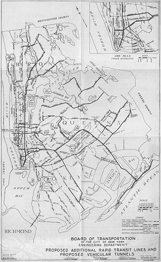
Since the opening of the original New York City Subway line in 1904, and throughout the subway's history, various official and planning agencies have proposed numerous extensions to the subway system. The first major expansion of the subway system was the Dual Contracts, a set of agreements between the City of New York and the IRT and the BRT. The system was expanded into the outer reaches of the Bronx, Brooklyn, and Queens, and it provided for the construction of important lines in Manhattan. This one expansion of the system provided for a majority of today's system.

<span class="mw-page-title-main">Flushing–Main Street station (IRT Flushing Line)</span> New York City Subway station in Queens

The Flushing–Main Street station is the eastern terminal on the IRT Flushing Line of the New York City Subway, located at Main Street and Roosevelt Avenue in Downtown Flushing, Queens. It is served by the 7 local train at all times and the <7> express train during rush hours in the peak direction.

<span class="mw-page-title-main">Mets–Willets Point station (IRT Flushing Line)</span> New York City Subway station in Queens

The Mets–Willets Point station is a rapid transit station on the IRT Flushing Line of the New York City Subway. Located near the Citi Field baseball stadium, it is served by the 7 train at all times and by the express <7> train rush hours in the peak direction or after sporting events. This station is located near Flushing Meadows–Corona Park in Willets Point, Queens, on Roosevelt Avenue between 114th and 126th Streets.

<span class="mw-page-title-main">103rd Street–Corona Plaza station</span> New York City Subway station in Queens

The 103rd Street–Corona Plaza station is a local station on the IRT Flushing Line of the New York City Subway, located at the intersection of 103rd Street and Roosevelt Avenue. It is served by the 7 train at all times.

<span class="mw-page-title-main">Junction Boulevard station</span> New York City Subway station in Queens

The Junction Boulevard station is an express station on the IRT Flushing Line of the New York City Subway, located at the intersection of Junction Boulevard and Roosevelt Avenue in Corona, Queens. It is served by the 7 train at all times and by rush hour peak-direction <7> express service.

<span class="mw-page-title-main">Queensboro Plaza station</span> New York City Subway station in Queens

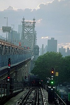
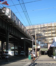
The Queensboro Plaza station is an elevated New York City Subway station at Queens Plaza in the Long Island City neighborhood of Queens. It is near the east end of the Queensboro Bridge, with Queens Boulevard running east from the plaza. The station is served by the 7 and N trains at all times, the W train on weekdays, and the <7> train rush hours in the peak direction.

<span class="mw-page-title-main">52nd Street station (IRT Flushing Line)</span> New York City Subway station in Queens

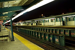
The 52nd Street station is a local station on the IRT Flushing Line of the New York City Subway. Located at the intersection of 52nd Street and Roosevelt Avenue in Woodside, Queens, it is served by the 7 train at all times.

<span class="mw-page-title-main">46th Street–Bliss Street station</span> New York City Subway station in Queens

The 46th Street–Bliss Street station is a local station on the IRT Flushing Line of the New York City Subway. Located at the intersection of 46th Street and Queens Boulevard in Sunnyside, Queens, it is served by the 7 train at all times.

<span class="mw-page-title-main">40th Street–Lowery Street station</span> New York City Subway station in Queens

The 40th Street–Lowery Street station is a local station on the IRT Flushing Line of the New York City Subway. It is served by the 7 local train at all times.

<span class="mw-page-title-main">33rd Street–Rawson Street station</span> New York City Subway station in Queens

The 33rd Street–Rawson Street station is a local station on the IRT Flushing Line of the New York City Subway. It is located over Queens Boulevard on a concrete viaduct. It is served by the 7 train at all times.

The IRT Flushing Line is a rapid transit route of the New York City Subway system, named for its eastern terminal in Flushing, Queens. It is operated as part of the A Division. The Interborough Rapid Transit Company (IRT), a private operator, had constructed the section of the line from Flushing, Queens, to Times Square, Manhattan between 1915 and 1928. A western extension was opened to Hudson Yards in western Manhattan in 2015, and the line now stretches from Flushing to Chelsea, Manhattan. It carries trains of the 7 local service, as well as the express <7> during rush hours in the peak direction. It is the only currently operational IRT line to serve Queens.

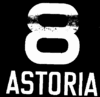
8 was a designation given to two New York City Subway services. It was first used by the Brooklyn–Manhattan Transit Corporation for its Astoria Line from 1917 to 1949. The ex-Interborough Rapid Transit Company (IRT) Third Avenue El subsequently used the designation between 1967 and 1973.

<span class="mw-page-title-main">Astoria–Ditmars Boulevard station</span> New York City Subway station in Queens

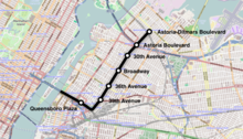
The Astoria–Ditmars Boulevard station, is the northern terminal station on the BMT Astoria Line of the New York City Subway. Located above 31st Street between 23rd Avenue and Ditmars Boulevard in Astoria, Queens, it is served by the N train at all times and the W train on weekdays.

<span class="mw-page-title-main">Astoria Boulevard station</span> New York City Subway station in Queens

The Astoria Boulevard station is an express station on the BMT Astoria Line of the New York City Subway. Located on 31st Street between Astoria Boulevard and the Grand Central Parkway in Astoria, Queens, the station is served by the N train at all times, as well as by the W train on weekdays.

<span class="mw-page-title-main">30th Avenue station</span> New York City Subway station in Queens

The 30th Avenue station is a local station on the BMT Astoria Line of the New York City Subway. It is located at 30th Avenue and 31st Street in Astoria. The station is served by the N train at all times, as well as by the W train on weekdays.

<span class="mw-page-title-main">Broadway station (BMT Astoria Line)</span> New York City Subway station in Queens

The Broadway station is a local station on the BMT Astoria Line of the New York City Subway. It is located above 31st Street at Broadway in Astoria, Queens. The station is served by the N train at all times, as well as by the W train on weekdays.

<span class="mw-page-title-main">36th Avenue station</span> New York City Subway station in Queens

The 36th Avenue station is a local station on the BMT Astoria Line of the New York City Subway. It is located at the intersection of 36th Avenue and 31st Street in Astoria, Queens. The station is served by the N train at all times, as well as by the W train on weekdays.

<span class="mw-page-title-main">39th Avenue station (BMT Astoria Line)</span> New York City Subway station in Queens

The 39th Avenue station is a local station on the BMT Astoria Line of the New York City Subway. It is located at 39th Avenue and 31st Street in Long Island City, Queens. The station is served by the N train at all times, as well as by the W train on weekdays.

References

  1. "Annual Subway Ridership (2017–2022)". Metropolitan Transportation Authority. 2022. Retrieved November 8, 2023.
  2. 1 2 "NSubway Timetable, Effective August 28, 2023". Metropolitan Transportation Authority . Retrieved August 26, 2023.
  3. 1 2 "WSubway Timetable, Effective June 26, 2022". Metropolitan Transportation Authority . Retrieved August 26, 2023.
  4. "Subway Service Guide" (PDF). Metropolitan Transportation Authority. September 2019. Retrieved September 22, 2019.
  5. 1 2 Dougherty, Peter (2006) [2002]. Tracks of the New York City Subway 2006 (3rd ed.). Dougherty. OCLC   49777633 via Google Books.
  6. 1 2 3 4 5 6 7 8 "First Train Runs On Elevated Line to Astoria Section". Brooklyn Daily Eagle . February 1, 1917. Retrieved June 29, 2015 via Newspapers.com.
  7. 1 2 1916-1917 Annual Report of the Interborough Rapid Transit Company For The Year June 30, 1917. Interborough Rapid Transit Company. 1917. p. 21.
  8. "New Astoria Line Opened". The New York Times. February 2, 1917. p. 14. ISSN   0362-4331 . Retrieved December 18, 2011.
  9. "Subway Link Over Queensboro Bridge". The New York Times. July 22, 1917. p. 31. ISSN   0362-4331 . Retrieved December 18, 2011.
  10. "New Subway Link Opens". The New York Times. August 1, 1920. p. 12. ISSN   0362-4331 . Retrieved December 18, 2011.
  11. "Additional Subway Service to Borough of Queens". The New York Times. April 8, 1923. p. RE1. ISSN   0362-4331 . Retrieved December 18, 2011.
  12. "Astoria Line Change". New York Daily News. July 15, 1949. Retrieved November 5, 2018.
  13. "Direct Subway Runs to Flushing, Astoria". The New York Times. October 15, 1949. p. 17. ISSN   0362-4331 . Retrieved December 18, 2011.
  14. Bulletin. General Contractors Association. 1950. p. 23.
  15. Proceedings of the Board of Transportation of The City of New York. New York City Board of Transportation. 1950. pp. 432, 729.
  16. "For Release Sunday, July 12, 1964" (PDF). New York City Office of the Mayor. July 12, 1964. Retrieved August 28, 2019.
  17. Whitford, Emma (January 8, 2016). "MTA Will Completely Close 30 Subway Stations For Months-Long "Revamp"". Gothamist. Archived from the original on August 1, 2016. Retrieved July 18, 2016.
  18. "MTAStations" (PDF). governor.ny.gov. Government of the State of New York. Retrieved July 18, 2016.
  19. 1 2 "Broadway & 39 Av NW Stations to Undergo Extensive Repairs & Renovations". mta.info. June 8, 2018. Archived from the original on June 12, 2018. Retrieved June 17, 2018.
  20. "Proposed Additions to Rapid Transit System to Cost $218,000,000". New York State Transit Commission. 1922. Retrieved August 1, 2019 via nycsubway.org.
  21. 100 Miles of Subway in New City Project; 52 of them in Queens, The New York Times September 16, 1929, p. 1. Retrieved June 11, 2014
  22. nycsubway.org—IND Second System – 1929 Plan
  23. Roess, Roger P.; Sansone, Gene (August 23, 2012). The Wheels That Drove New York: A History of the New York City Transit System. Springer Science & Business Media. ISBN   9783642304842.
  24. "Dreams of taking the N to LaGuardia". Second Ave. Sagas. January 19, 2010. Retrieved May 1, 2016.
  25. "Second Avenue Subway Supplemental Draft Environmental Impact Statement (SDEIS), April 2003 Appendix A Planning Context" (PDF). mta.info. Metropolitan Transportation Authority. April 2003. Retrieved August 9, 2016.
  26. Toscano, John (July 16, 2003). "N Train Extension To LaG Scrapped". Queens Gazette. Archived from the original on May 25, 2009. Retrieved July 26, 2009.
  27. "Flashback To 1999". www.qgazette.com. June 27, 2007. Archived from the original on March 22, 2016. Retrieved March 25, 2014.
  28. Guse, Clayton (November 16, 2021). "Port Authority brings in MTA, transit experts to reexamine subway extension to LaGuardia Airport". New York Daily News .
  29. "Fourth Regional Plan - Regional Plan Association". Regional Plan Association. November 2017. Retrieved January 22, 2022.
Template:Attached KML/BMT Astoria Line
KML is from Wikidata

Commons-logo.svg Media related to BMT Astoria Line at Wikimedia Commons