List of New York City Subway lines

Last updated

The Queens Boulevard viaduct of the IRT Flushing Line Qns blvd 39st jeh.JPG
The Queens Boulevard viaduct of the IRT Flushing Line

The New York City Subway is a heavy-rail public transit system serving four of the five boroughs of New York City. The present New York City Subway system inherited the systems of the Interborough Rapid Transit Company (IRT), Brooklyn–Manhattan Transit Corporation (BMT), and the Independent Subway System (IND). New York City has owned the IND since its inception; the BMT and IRT were taken over by the city in 1940. The former IRT system is now known as the A Division, while the B Division is the combined former BMT and IND systems.

Contents

In the New York City Subway nomenclature, a "line" refers to the physical trackage used by trains that are used by numbered or lettered "services"; the services that run on certain lines change periodically. Today, the division or company names are not used publicly, while the line names may occasionally be used.

Nomenclature

In the nomenclature of the subway, the terms "line" and "service" are not interchangeable with each other. While in popular usage the word "line" is often used synonymously with "service" (even sometimes on the website of the MTA [1] ), this list will use the formal usage of the term "line."

A line is the physical structure and tracks that trains run over. Each section of the system is assigned a unique line name that begins with a division (IRT, BMT or IND), which is its pre-unification division when applicable. For example, the line under Eighth Avenue is the IND Eighth Avenue Line. Some lines have changed names (and even divisions), but this happens relatively infrequently.

By contrast, a service refers to the route that a train takes across the various lines. A service can operate along several lines and even along different divisions. For example, the R service operates along the IND Queens Boulevard Line as well as the BMT Broadway Line and the BMT Fourth Avenue Line.

Each service is assigned a color. Since 1979, each service's color corresponds to the line it primarily uses in Midtown Manhattan [ original research? ]—defined as the trunk line. There are three exceptions: the IND Crosstown Line, which does not carry services to Manhattan, is colored light green; the BMT Nassau Street Line, which runs only through Lower Manhattan, is colored brown; and all shuttles are colored dark gray. [2] The list of trunk lines and colors is shown in the table below.

Primary Trunk lineColor [3] [4] Pantone [5] Hexadecimal Service bullets
IND Eighth Avenue Line Blue PMS 286#0039a6 NYCS-bull-trans-A-Std.svg NYCS-bull-trans-C-Std.svg NYCS-bull-trans-E-Std.svg
IND Sixth Avenue Line Orange PMS 165#ff6319 NYCS-bull-trans-B-Std.svg NYCS-bull-trans-D-Std.svg NYCS-bull-trans-F-Std.svg NYCS-bull-trans-Fd-Std.svg NYCS-bull-trans-M-Std.svg
IND Crosstown Line Lime PMS 376#6cbe45 NYCS-bull-trans-G-Std.svg
BMT Canarsie Line Light slate gray 50% black#a7a9ac NYCS-bull-trans-L-Std.svg
BMT Nassau Street Line Brown PMS 154#996633 NYCS-bull-trans-J-Std.svg NYCS-bull-trans-Z-Std.svg
BMT Broadway Line Yellow PMS 116#fccc0a NYCS-bull-trans-N-Std.svg NYCS-bull-trans-Q-Std.svg NYCS-bull-trans-R-Std.svg NYCS-bull-trans-W-Std.svg
IRT Broadway–Seventh Avenue Line Red PMS 185#ee352e NYCS-bull-trans-1-Std.svg NYCS-bull-trans-2-Std.svg NYCS-bull-trans-3-Std.svg
IRT Lexington Avenue Line Green PMS 355#00933c NYCS-bull-trans-4-Std.svg NYCS-bull-trans-5-Std.svg NYCS-bull-trans-6-Std.svg NYCS-bull-trans-6d-Std.svg
IRT Flushing Line Purple PMS Purple#b933ad NYCS-bull-trans-7-Std.svg NYCS-bull-trans-7d-Std.svg
IND Second Avenue Line Turquoise PMS 638#00add0 NYCS-bull-trans-T-Std.svg
Shuttles Dark slate gray 70% black#808183 NYCS-bull-trans-S-Std.svg

Line listing

There are currently 36 rail lines. The Archer Avenue Lines and the 63rd Street Lines are each classified as two separate lines due to their structure: both lines have a distinct sections that are chained as BMT and the IND lines.

In the list below, lines with colors next to them indicate trunk lines, which determine the colors that are used for services' route bullets and diamonds, as well as shuttle service lines. The opening date refers to the opening of the first section of track for the line. In the "division" column, the current division is followed by the original division in parentheses.

DivisionLineBorough(s)Service(s)OpenedStructure
B (IND)  Second Avenue Line Manhattan    N   NYCS-SSI-rushonly.svg
   Q   NYCS-SSI-alltimes.svg
   R   NYCS-SSI-rushpeak.svg
January 1, 2017 [6] underground
B (BMT) Brooklyn    D   NYCS-SSI-alltimes.svg
   N   NYCS-SSI-alltimes.svg
   Q   NYCS-SSI-rushonly.svg
   R   NYCS-SSI-alltimes.svg
   W   NYCS-SSI-rushonly.svg
June 22, 1915 [7] underground
B (IND)  Sixth Avenue Line Manhattan
Brooklyn
   B   NYCS-SSI-weekdaysonly.svg
   D   NYCS-SSI-alltimes.svg
   F   NYCS-SSI-alltimes.svg <F> NYCS-SSI-rushpeak.svg
   M   NYCS-SSI-weekdaysonly.svg
January 1936 [8] underground
B (IND)  Eighth Avenue Line Manhattan
Brooklyn
   A   NYCS-SSI-alltimes.svg
   B   NYCS-SSI-weekdaysonly.svg
   C   NYCS-SSI-allexceptnights.svg
   D   NYCS-SSI-alltimes.svg
   E   NYCS-SSI-alltimes.svg
September 10, 1932 [9] underground
A (IRT) 42nd Street Shuttle Manhattan    S   NYCS-SSI-allexceptnights.svg October 27, 1904 [10] underground [a]
B (BMT) 63rd Street Line Manhattan    N   NYCS-SSI-rushonly.svg
   Q   NYCS-SSI-alltimes.svg
   R   NYCS-SSI-rushpeak.svg
October 29, 1989 [9] underground
B (IND) 63rd Street Line Manhattan
Queens
   F   NYCS-SSI-allexceptnights.svg October 29, 1989 [9] underground
B (BMT) Archer Avenue Line Queens    J   NYCS-SSI-alltimes.svg
   Z   NYCS-SSI-rushpeak.svg
December 11, 1988 [7] underground
B (IND) Archer Avenue Line Queens    E   NYCS-SSI-alltimes.svg December 11, 1988 [9] underground
B (BMT) Astoria Line Queens    N   NYCS-SSI-alltimes.svg
   W   NYCS-SSI-weekdaysonly.svg
April 21, 1917 [11] elevated
B (BMT) Brighton Line Brooklyn    B   NYCS-SSI-weekdaysonly.svg
   Q   NYCS-SSI-alltimes.svg
July 2, 1878 [12] underground, open cut, at-grade, embankment, elevated
B (BMT)  Broadway Line Manhattan    N   NYCS-SSI-alltimes.svg
   Q   NYCS-SSI-alltimes.svg
   R   NYCS-SSI-allexceptnights.svg
   W   NYCS-SSI-weekdaysonly.svg
September 4, 1917 [7] underground
A (IRT)  Broadway–Seventh Avenue Line Bronx
Manhattan
Brooklyn
   1   NYCS-SSI-alltimes.svg
   2   NYCS-SSI-alltimes.svg
   3   NYCS-SSI-alltimes.svg
October 27, 1904 [10] elevated [a] , embankment, underground
B (BMT)  Canarsie Line Manhattan
Brooklyn
   L   NYCS-SSI-alltimes.svg October 21, 1865 [13] underground, elevated, at-grade
B (IND) Concourse Line Bronx
Manhattan
   B   NYCS-SSI-weekdaysonly.svg
   D   NYCS-SSI-alltimes.svg
July 1, 1933 [9] underground
B (IND)  Crosstown Line Brooklyn
Queens
   G   NYCS-SSI-alltimes.svg August 19, 1933 [9] underground
B (IND) Culver Line Brooklyn    F   NYCS-SSI-alltimes.svg <F> NYCS-SSI-rushpeak.svg
   G   NYCS-SSI-alltimes.svg
March 16, 1919 [7] underground, elevated [c]
A (IRT) Dyre Avenue Line Bronx    5   NYCS-SSI-alltimes.svg May 15, 1941elevated [b] , embankment, open-cut, underground
A (IRT) Eastern Parkway Line Brooklyn    2   NYCS-SSI-alltimes.svg
   3   NYCS-SSI-allexceptnights.svg
   4   NYCS-SSI-alltimes.svg
   5   NYCS-SSI-weekdaysonly.svg
January 9, 1908 [10] underground
A (IRT)  Flushing Line Manhattan
Queens
   7   NYCS-SSI-alltimes.svg <7> NYCS-SSI-rushpeak.svg June 22, 1915 [10] underground, elevated
B (BMT) Franklin Avenue Line Brooklyn    S   NYCS-SSI-alltimes.svg July 2, 1878 [12] elevated, embankment, open cut
B (IND) Fulton Street Line Brooklyn
Queens
   A   NYCS-SSI-alltimes.svg
   C   NYCS-SSI-allexceptnights.svg
April 9, 1936 [9] underground, elevated [d]
B (BMT) Jamaica Line Brooklyn
Queens
   J   NYCS-SSI-alltimes.svg
   M   NYCS-SSI-alltimes.svg
   Z   NYCS-SSI-rushpeak.svg
February 2, 1885 [7] elevated
A (IRT) Jerome Avenue Line Bronx    4   NYCS-SSI-alltimes.svg
   5   NYCS-SSI-allexceptnights.svg
June 12, 1917 [10] elevated, underground
A (IRT) Lenox Avenue Line Manhattan    2   NYCS-SSI-alltimes.svg
   3   NYCS-SSI-alltimes.svg
November 23, 1904 [10] at-grade, underground
A (IRT)  Lexington Avenue Line Manhattan    4   NYCS-SSI-alltimes.svg
   5   NYCS-SSI-allexceptnights.svg
   6   NYCS-SSI-alltimes.svg <6> NYCS-SSI-rushpeak.svg
October 27, 1904 [10] underground [a]
B (BMT) Myrtle Avenue Line Brooklyn
Queens
   M   NYCS-SSI-alltimes.svg December 19, 1889 [7] elevated, embankment, at-grade
B (BMT)  Nassau Street Line Manhattan    J   NYCS-SSI-alltimes.svg
   M   NYCS-SSI-allexceptnights.svg
   Z   NYCS-SSI-rushpeak.svg
September 16, 1908 [7] underground
A (IRT) New Lots Line Brooklyn    2   NYCS-SSI-rushreversepeak.svg
   3   NYCS-SSI-allexceptnights.svg
   4   NYCS-SSI-nightsonly.svg
   5   NYCS-SSI-rushpeak.svg
November 23, 1920 [10] elevated
A (IRT) Nostrand Avenue Line Brooklyn    2   NYCS-SSI-alltimes.svg
   5   NYCS-SSI-weekdaysonly.svg
August 23, 1920 [10] underground
A (IRT) Pelham Line Bronx    6   NYCS-SSI-alltimes.svg <6> NYCS-SSI-rushpeak.svg August 1, 1918 [10] underground, elevated
B (IND) Queens Boulevard Line Manhattan
Queens
   E   NYCS-SSI-alltimes.svg
   F   NYCS-SSI-alltimes.svg <F> NYCS-SSI-rushpeak.svg
   R   NYCS-SSI-allexceptnights.svg
August 19, 1933 [9] underground
B (IND) Rockaway Line Queens    A   NYCS-SSI-alltimes.svg
   S   NYCS-SSI-alltimes.svg
June 28, 1956at-grade, embankment, elevated [e]
B (BMT) Sea Beach Line Brooklyn    N   NYCS-SSI-alltimes.svg
   Q   NYCS-SSI-rushonly.svg
   W   NYCS-SSI-rushonly.svg
June 22, 1915 [7] open cut, elevated
B (BMT) West End Line Brooklyn    D   NYCS-SSI-alltimes.svg June 24, 1916 [7] open-cut, elevated
A (IRT) White Plains Road Line Bronx    2   NYCS-SSI-alltimes.svg
   5   NYCS-SSI-alltimes.svg
July 10, 1905 [10] elevated, underground

Inter-division connections

The following list shows the connections between the different divisions of the New York City Subway. [14] [ dubious ]

Purpose-built

These connections can be used by trains in revenue service:

This connection is not for revenue service due to the differing widths of the trains:

Yards

These connections are located within the subway's rail yards and are not intended for revenue service.

Other

Unused connections in the same division

In some places, there are track connections within the same division that are unused in regular service. [15]

Brooklyn

Manhattan

Queens

Unused center tracks

Many of the New York City Subway's lines have express tracks, unused in revenue service and generally only used for re-routes. [16]

The Bronx

Brooklyn

Manhattan

Queens

Above ground sections

A map of the New York City Subway by line placement. Underground is in orange. Elevated, at-grade, embankment, open-cut is in blue. Nyc subway underground or overground track position.svg
A map of the New York City Subway by line placement. Underground is in orange. Elevated, at-grade, embankment, open-cut is in blue.

A majority[ original research? ] of the New York City Subway is underground, but the following segments are located above ground level. [17] [ dubious ]

The Bronx

Brooklyn

Manhattan

Queens

Trackage

A map of the New York City Subway by the number of tracks on line segments. NYC Subway number of tracks.svg
A map of the New York City Subway by the number of tracks on line segments.

At minimum, in normal revenue service, all lines have two tracks, with one exception: the BMT Franklin Avenue Line has a single track between Franklin Avenue and Park Place.

Three-tracked portions

The New York City Subway has fewer triple track sections than it has quadruple track sections[ original research? ]. These sections are listed below. The third track, when in use, is generally for peak-direction express service or reroutes, with exceptions noted below.

  1. IRT Broadway–Seventh Avenue Line ( 1 train) from south of Van Cortlandt Park–242nd Street to north of Dyckman Street and from north of 145th Street to north of 96th Street
  2. IRT White Plains Road Line ( 2 and 5 trains) from south of Wakefield–241st Street to east of Third Avenue–149th Street
  3. IRT Lenox Avenue Line ( 2 and 3 trains) at 135th Street – center track is not usable in revenue service
  4. IRT Jerome Avenue Line ( 4 train) – entire line, except for Woodlawn
  5. IRT Dyre Avenue Line ( 5 train) – entire line
  6. IRT Pelham Line ( 6 and <6> trains) – entire line
  7. IRT Flushing Line ( 7 and <7> trains) – from 33rd Street–Rawson Street to Flushing–Main Street
  8. IRT New Lots Line ( 2 , 3 , 4 , and 5 trains) at Junius Street – center track is not usable in revenue service
  9. IND Fulton Street Line ( A train) – from west of 80th Street to west of Ozone Park–Lefferts Boulevard; the westernmost portion of this track goes to Pitkin Yard
  10. BMT West End Line ( D train) – from Ninth Avenue to Bay 50th Street
  11. IND Concourse Line ( B and D trains) – from 145th Street to Bedford Park Boulevard
  12. IND Culver Line ( F and <F> trains) – from south of Church Avenue to Avenue X
  13. BMT Jamaica Line ( J , M , and Z trains) – from Marcy Avenue to Broadway Junction. Also, at 111th Street, the center track is not usable in revenue service
  14. BMT Canarsie Line ( L train) at East 105th Street – easternmost track is not usable in revenue service
  15. BMT Astoria Line ( N and W trains) – from east of Queensboro Plaza to south of Astoria–Ditmars Boulevard
  16. IND Crosstown Line ( G train) at Bedford–Nostrand Avenues – middle track can be used to turn trains coming from either direction
  17. BMT Broadway Line at Whitehall Street – middle track used to turn southbound (W) and northbound (R) trains
  18. BMT Sea Beach Line (Eighth Avenue to 86th Street)

Additionally, there are several pocket tracks in the subway where the line temporarily widens from two to three tracks, such as east of Eighth Avenue on the BMT Canarsie Line, and south of Court Square on the IND Crosstown Line.

Four-tracked portions

Quadruple-tracked portions of track are fairly common in the subway system. This makes it unique among most metro systems in the world, as most others only have two tracks per line. Generally, these portions are a pair of express and a pair of local tracks unless otherwise noted.

  1. Trunk lines:
    1. IND Sixth Avenue Line between Broadway– Lafayette Street and 47th–50th Streets
    2. IND Eighth Avenue Line between Chambers Street–World Trade Center and 168th Street, and again at Dyckman Street (two local tracks and two tracks leading to the 207th Street Yard)
    3. IRT Lexington Avenue Line between Brooklyn Bridge–City Hall and 125th Street
    4. IRT Broadway–Seventh Avenue Line between Chambers and 96th Streets
    5. BMT Broadway Line between Canal Street and 57th Street–Seventh Avenue
    6. BMT Nassau Street Line at Chambers Street (originally a four platform station)
  2. Branch lines:
    Manhattan branches:
    1. 63rd Street Lines at Lexington Avenue (two levels of one-direction tracks, with both levels containing one track each of IND and BMT, with connections between lines on both levels)
    2. Chrystie Street Connection (one pair IND and one pair BMT)
    3. Manhattan Bridge (one pair of tracks on each of the north and south sides of the bridge)
    Queens branches:
    1. IND Queens Boulevard Line east of Queens Plaza
    2. IND Rockaway Line north of Jamaica Bay
    3. Archer Avenue Lines from Sutphin Boulevard and east (two levels of paired tracks: all IND on one, all BMT on the other, without connections between lines)
    4. IRT Flushing Line and BMT Astoria Line at Queensboro Plaza (two levels of one-direction tracks, with both levels containing one track each of IRT and BMT, with a non-revenue connection between lines on upper level)
    Brooklyn branches:
    1. IRT Eastern Parkway Line (entire line)
    2. IND Culver Line north of Church Avenue
    3. IND Fulton Street Line between Hoyt–Schermerhorn Streets and Euclid Avenue
    4. BMT Brighton Line between Ocean Parkway and Prospect Park
    5. BMT Fourth Avenue Line north of 59th Street
    6. Manhattan Bridge (one pair of tracks on each of the north and south sides of the bridge)

The Bronx has no four-tracked lines. Pocket tracks are not included.

Defunct lines

The following New York City Subway lines are either entirely defunct or have major portions no longer in service. Defunct spur lines with one station, such as the South Ferry loops, are not included in this list, nor are surface transit lines.

DivisionLineBorough(s)OpenedClosedStructureStatus
A (IRT) Manhattan March 1, 1880June 13, 1942elevatedEntirely demolished
A (IRT)

Third Avenue Line Manhattan August 26, 1878May 12, 1955elevatedEntirely demolished
Bronx April 28, 1973Entirely demolished; had been replaced for a time by the Bx55 and then Bx15 Limited buses.
B (BMT) Brooklyn October 1, 1893May 31, 1940elevatedEntirely demolished
B (BMT) Brooklyn 1888–1890May 31, 1940elevatedEntirely demolished
A (IRT) Manhattan 1878December 4, 1938elevatedEntirely demolished
A (IRT)

Ninth Avenue Line Manhattan July 1, 1868June 11, 1940elevatedEntirely demolished
Bronx August 31, 1958Entirely demolished, except for the two underground stations at Sedgwick Avenue and Anderson–Jerome Avenues in the Bronx
B (BMT) Canarsie Line Brooklyn 1865November 21, 1942at-gradeLine from Canarsie–Rockaway Parkway to Canarsie Pier replaced with a streetcar line, which itself was replaced by the B42 bus.
B (BMT) Culver Line Brooklyn 1875elevatedLine from Ditmas Avenue to Coney Island–Stillwell Avenue taken over by the IND in 1954 [c]
May 11, 1975Remainder of line to Ninth Avenue abandoned, then demolished in 1985.
B (BMT) Fulton Street Line Brooklyn 1888–1894a) May 31, 1940
b) April 26, 1956
elevateda) Line demolished west of Rockaway Avenue.
b) Remainder of line in Brooklyn demolished.
Queens September 25, 1915Line taken over by the IND in 1956, with the western two-block section rebuilt to connect with Grant Avenue.
A (IRT) IRT trunk line Manhattan 1904undergroundSeparated into the Broadway–Seventh Avenue, Lexington Avenue and 42nd Street Shuttle lines [a]
B (BMT) Lexington Avenue Line Brooklyn May 13, 18851889–1950elevatedLine west of Gates Avenue demolished
B (BMT) Jamaica Line Brooklyn 1885–1888July 3, 1916elevatedLine west of Marcy Avenue demolished
Queens 1918a) September 10, 1977
b) April 15, 1985
a) Line east of Queens Boulevard demolished.
b) Line east of 121st Street demolished.
Both segments were replaced with Q49 bus service, which itself was replaced in 1988 by the BMT Archer Avenue Line.
B (BMT) Myrtle Avenue Line Brooklyn 1888–18891944–1969elevatedLine west of Central Avenue through Broadway to Lewis Avenue abandoned. Remainder of line west of Lewis Avenue demolished.
B (IND) World's Fair Line Queens 19391940at-gradeEntirely demolished

Vestiges of former lines

See also

Notes

Related Research Articles

<span class="mw-page-title-main">Brooklyn–Manhattan Transit Corporation</span> Defunct transit operator in New York City

The Brooklyn–Manhattan Transit Corporation (BMT) was an urban transit holding company, based in Brooklyn, New York City, United States, and incorporated in 1923. The system was sold to the city in 1940. Today, together with the IND subway system, it forms the B Division of the modern New York City Subway.

<span class="mw-page-title-main">Independent Subway System</span> Defunct subway operator in New York City

The Independent Subway System was a rapid transit rail system in New York City that is now part of the New York City Subway. It was first constructed as the Eighth Avenue Line in Manhattan in 1932. It was originally also known as the Independent City-Owned Subway System (ICOSS) or the Independent City-Owned Rapid Transit Railroad (ICORTR).

<span class="mw-page-title-main">Proposed expansion of the New York City Subway</span>

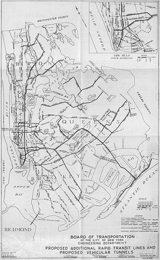
Since the opening of the original New York City Subway line in 1904, and throughout the subway's history, various official and planning agencies have proposed numerous extensions to the subway system. The first major expansion of the subway system was the Dual Contracts, a set of agreements between the City of New York and the IRT and the BRT. The system was expanded into the outer reaches of the Bronx, Brooklyn, and Queens, and it provided for the construction of important lines in Manhattan. This one expansion of the system provided for a majority of today's system.

<span class="mw-page-title-main">Dual Contracts</span> Transit contracts in New York City

The Dual Contracts, also known as the Dual Subway System, were contracts for the construction and/or rehabilitation and operation of rapid transit lines in the City of New York. The contracts were signed on March 19, 1913, by the Interborough Rapid Transit Company and the Brooklyn Rapid Transit Company. As part of the Dual Contracts, the IRT and BRT would build or upgrade several subway lines in New York City, then operate them for 49 years.

<span class="mw-page-title-main">Chrystie Street Connection</span> New York City Subway track connections

The Chrystie Street Connection is a set of New York City Subway tunnels running the length of Chrystie Street on the Lower East Side of Manhattan. It is one of the few track connections between lines of the former Brooklyn–Manhattan Transit Corporation (BMT) and Independent Subway System (IND) divisions, which together constitute the system's B Division. A major branch of the IND Sixth Avenue Line, it connects the Sixth Avenue Line to the BMT Brighton Line and BMT Fourth Avenue Line via the north side of the Manhattan Bridge and to the BMT Jamaica Line over the Williamsburg Bridge. The project, opened in 1967 and 1968, also includes the Sixth Avenue Line's Grand Street and 57th Street stations, the latter of which is not part of the connection itself.

The BMT Canarsie Line is a rapid transit line of the B Division of the New York City Subway system, named after its terminus in the Canarsie neighborhood of Brooklyn. It is served by the L train at all times, which is shown in medium gray on the New York City Subway map and on station signs.

<span class="mw-page-title-main">New York City Subway nomenclature</span> Terminology of the New York City Subway

New York City Subway nomenclature is the terminology used in the New York City Subway system as derived from railroading practice, historical origins of the system, and engineering, publicity, and legal usage. Important terms include lines, or individual sections of subway, like the BMT Brighton Line; services, like the B, which is a single train route along several lines; and stations, such as Coney Island–Stillwell Avenue, which connects multiple lines and services.

The BMT Jamaica Line, also known as the Broadway - Brooklyn Line is an elevated rapid transit line of the B Division of the New York City Subway, in Brooklyn and Queens, New York City, United States. It runs from the Williamsburg Bridge southeast over Broadway to East New York, Brooklyn, and then east over Fulton Street and Jamaica Avenue to Jamaica, Queens. In western Jamaica, the line goes into a tunnel, becoming the lower level of the Archer Avenue lines in central Jamaica. The J and Z trains serve the entire length of the Jamaica Line, and the M serves the line west of Myrtle Avenue.

<span class="mw-page-title-main">New York City Subway chaining</span> Method to specify locations along the New York City Subway lines

New York City Subway chaining is a method to precisely specify locations along the New York City Subway lines. It measures distances from a fixed point, called chaining zero, following the twists and turns of the railroad line, so that the distance described is understood to be the "railroad distance," not the distance by the most direct route.

<span class="mw-page-title-main">History of the New York City Subway</span>

The New York City Subway is a rapid transit system that serves four of the five boroughs of New York City, New York: the Bronx, Brooklyn, Manhattan, and Queens. Its operator is the New York City Transit Authority (NYCTA), which is controlled by the Metropolitan Transportation Authority (MTA) of New York. In 2016, an average of 5.66 million passengers used the system daily, making it the busiest rapid transit system in the United States and the seventh busiest in the world.

<span class="mw-page-title-main">13 (BMT rapid transit service)</span> Former New York City Subway service (ceased 1956)

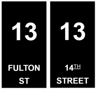
13 was the BMT's designation for service on the BMT Fulton Street Line, not to be confused with today's IND Fulton Street Line, which uses a portion of the old BMT line at its east end.

<span class="mw-page-title-main">Unused New York City Subway service labels</span>

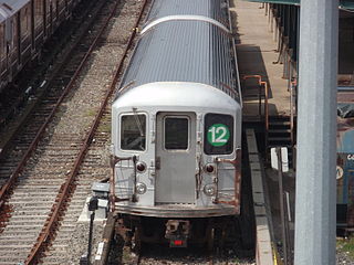
The New York City Subway currently uses various letters and numbers to designate the routes that trains use over the differing lines in the system. Along with the color corresponding to the route's trunk line, these form a unique identifier for the route, easing navigation through the complex system. Several service labels have either been phased out or never been used. This list covers the labels not used as of June 2021.

Starting in 1899, the Brooklyn Rapid Transit Company and Brooklyn–Manhattan Transit Corporation operated rapid transit lines in New York City — at first only elevated railways and later also subways.

<span class="mw-page-title-main">Broadway Junction station</span> New York City Subway station complex in Brooklyn

The Broadway Junction station is a New York City Subway station complex shared by the elevated BMT Canarsie Line and BMT Jamaica Line, and the underground IND Fulton Street Line. It was also served by trains of the Fulton Street Elevated until that line closed in 1956. It is located roughly at the intersection of Broadway, Fulton Street and Van Sinderen Avenue at the border of Bedford–Stuyvesant and East New York, Brooklyn. The complex is served by the A, J, and L trains at all times; the C train at all times except late nights; and the Z train during rush hours in the peak direction only.

The New York City Subway's B Division consists of the lines that operate with lettered services, as well as the Franklin Avenue and Rockaway Park Shuttles. These lines and services were operated by the Brooklyn–Manhattan Transit Corporation (BMT) and city-owned Independent Subway System (IND) before the 1940 city takeover of the BMT. B Division rolling stock is wider, longer, and heavier than those of the A Division, measuring 10 or 9.75 ft by 60 or 75 ft.

References

  1. Subway Line Information Archived May 16, 2012, at the Wayback Machine
  2. Hogarty, Dave (August 3, 2007). "Michael Hertz, Designer of the NYC Subway Map". Gothamist . Archived from the original on August 18, 2009. Retrieved July 4, 2009.
  3. Official paint monikers since the colors were fixed in 1979: Grynbaum, Michael (May 10, 2010). "Take the Tomato 2 Stops to the Sunflower". New York Times, City Room Blog. Retrieved May 11, 2010.
  4. Official MTA video mentions "lime green" for the G line. "Subway Colors and Names". MTA Info. July 15, 2010. Retrieved August 5, 2010.
  5. MTA Developer Resources Download, CSV file
  6. Rivoli, Dan; Sandoval, Edgar; Greene, Leonard (December 18, 2016). "Cuomo promises Second Ave. subway will open Jan. 1". NY Daily News. Retrieved December 19, 2016.
  7. 1 2 3 4 5 6 7 8 9 "New York City Subway BMT Division Timeline". www.nycsubway.org. Retrieved May 7, 2009.
  8. "New York City Subway IND 6th Ave Line". www.nycsubway.org. Retrieved May 7, 2009.
  9. 1 2 3 4 5 6 7 8 "New York City Subway IND Division Timeline". www.nycsubway.org. Retrieved May 7, 2009.
  10. 1 2 3 4 5 6 7 8 9 10 11 "New York City Subway IRT Division Timeline". www.nycsubway.org. Retrieved May 7, 2009.
  11. "First Train Runs On Elevated Line to Astoria Section". Brooklyn Daily Eagle . February 1, 1917. Retrieved June 29, 2015 via Newspapers.com.
  12. 1 2 "New York City Subway Brighton Beach Line". www.nycsubway.org. Retrieved May 7, 2009.
  13. Feinman, Mark S. (February 17, 2001). "Early Rapid Transit in Brooklyn, 1878–1913". www.nycsubway.org. Retrieved August 10, 2015.
  14. "Subway FAQ: Interconnections Between IRT and IND–BMT Divisions". www.nycsubway.org. Retrieved November 12, 2013.
  15. "Subway FAQ: Unused Track Connections". www.nycsubway.org. Retrieved November 12, 2013.
  16. "Subway FAQ: Unused Express Tracks". www.nycsubway.org. Retrieved November 12, 2013.
  17. "Subway FAQ: Elevated Sections of the Subway". www.nycsubway.org. Retrieved November 12, 2013.