Bedford, Iowa

Last updated

Bedford, Iowa
Bedford, IA.jpg
Taylor County Iowa Incorporated and Unincorporated areas Bedford Highlighted.svg
Location of Bedford, Iowa
Coordinates: 40°40′16″N94°43′26″W / 40.67111°N 94.72389°W / 40.67111; -94.72389
Country Flag of the United States.svg  United States
State Flag of Iowa.svg  Iowa
County Taylor
Government
   Mayor Matt Churchill
Area
[1]
  Total1.61 sq mi (4.18 km2)
  Land1.60 sq mi (4.16 km2)
  Water0.01 sq mi (0.02 km2)
Elevation
[2]
1,171 ft (357 m)
Population
 (2020)
  Total1,508
  Density939.56/sq mi (362.70/km2)
Time zone UTC-6 (Central (CST))
  Summer (DST) UTC-5 (CDT)
ZIP code
50833
Area code 712
FIPS code 19-05365
GNIS feature ID2394105 [2]
Website www.bedfordia.org

Bedford is a city in Taylor County, Iowa, United States. The population was 1,508 at the 2020 census. [3] It is the county seat of Taylor County. [4] Lake of Three Fires State Park is located several miles northeast of Bedford.

Contents

History

The community is believed to have gotten its name from Thomas J. Bedford, who was the first west bound Pony Express rider to deliver the mail on its final leg from Benicia, California to Oakland, California on April 23, 1861. Bedford is believed to have operated Bedfords Store and Trading Post in 1848 within the city limits. He moved to California later that year, in the California Gold Rush. [5]

The community was called "Grove" when a post office was established on June 30, 1855. On June 24, 1856 it was changed to Bedford. Other histories have noted possible other sources of the name: [6]

The community was formally established as the county seat of Taylor County by a legislative act in 1853. The town was formally laid out on lots sold on July 4, 1853 (which at the time identified the community as "Bedforde"). According to town legend, a barrel of whiskey was placed on the grounds and lots sold for $10 to $20 - although none of the lots were paid for at the time. [7]

The present Taylor County Courthouse was built in 1893.

Bedford was served by a branch of the Burlington Northern Railroad (formerly Chicago, Burlington and Quincy Railroad or "CB&Q") that ran from Creston, Iowa to St. Joseph, Missouri This line was removed along with almost all the branches in southwestern Iowa and northwestern Missouri in the late 1970s to early 1980s [8]

Bedford is also served by Iowa Highway 138 which runs north and south into Missouri, and Iowa Highway 2 runs east and west and connects most of the county seats in the southern tier of Iowa counties. There is an excellent series of farm to market road system , mostly paved, as well. [9]

Geography

Bedford is located along the East Fork of the One Hundred and Two River.

According to the United States Census Bureau, the city has a total area of 1.61 square miles (4.17 km2), of which 1.60 square miles (4.14 km2) is land and 0.01 square miles (0.03 km2) is water. [10]

Climate

According to the Köppen Climate Classification system, Bedford has a hot-summer humid continental climate, abbreviated "Dfa" on climate maps.

Climate data for Bedford, Iowa, 1991–2020 normals, extremes 1898–2018
MonthJanFebMarAprMayJunJulAugSepOctNovDecYear
Record high °F (°C)68
(20)
76
(24)
90
(32)
94
(34)
97
(36)
102
(39)
110
(43)
108
(42)
107
(42)
94
(34)
81
(27)
70
(21)
110
(43)
Mean maximum °F (°C)55.0
(12.8)
60.2
(15.7)
74.2
(23.4)
83.3
(28.5)
86.5
(30.3)
91.7
(33.2)
96.1
(35.6)
95.0
(35.0)
90.0
(32.2)
82.3
(27.9)
69.2
(20.7)
56.1
(13.4)
97.5
(36.4)
Average high °F (°C)31.9
(−0.1)
37.1
(2.8)
49.9
(9.9)
62.0
(16.7)
72.0
(22.2)
81.6
(27.6)
85.6
(29.8)
84.0
(28.9)
77.1
(25.1)
64.7
(18.2)
49.4
(9.7)
36.8
(2.7)
61.0
(16.1)
Daily mean °F (°C)22.2
(−5.4)
26.7
(−2.9)
38.7
(3.7)
50.1
(10.1)
61.3
(16.3)
71.3
(21.8)
75.5
(24.2)
73.6
(23.1)
65.4
(18.6)
52.8
(11.6)
38.9
(3.8)
27.6
(−2.4)
50.3
(10.2)
Average low °F (°C)12.4
(−10.9)
16.3
(−8.7)
27.6
(−2.4)
38.2
(3.4)
50.5
(10.3)
61.1
(16.2)
65.4
(18.6)
63.1
(17.3)
53.7
(12.1)
40.9
(4.9)
28.5
(−1.9)
18.4
(−7.6)
39.7
(4.3)
Mean minimum °F (°C)−9.0
(−22.8)
−4.5
(−20.3)
7.7
(−13.5)
22.9
(−5.1)
36.6
(2.6)
47.6
(8.7)
54.5
(12.5)
51.6
(10.9)
36.8
(2.7)
24.5
(−4.2)
11.8
(−11.2)
−4.4
(−20.2)
−15.2
(−26.2)
Record low °F (°C)−32
(−36)
−34
(−37)
−24
(−31)
1
(−17)
19
(−7)
37
(3)
40
(4)
37
(3)
22
(−6)
10
(−12)
−11
(−24)
−30
(−34)
−34
(−37)
Average precipitation inches (mm)1.08
(27)
1.49
(38)
2.42
(61)
3.60
(91)
5.27
(134)
5.54
(141)
4.64
(118)
4.32
(110)
3.38
(86)
2.97
(75)
2.13
(54)
1.59
(40)
38.43
(975)
Average snowfall inches (cm)7.6
(19)
7.2
(18)
3.3
(8.4)
1.3
(3.3)
0.0
(0.0)
0.0
(0.0)
0.0
(0.0)
0.0
(0.0)
0.0
(0.0)
0.1
(0.25)
0.7
(1.8)
7.9
(20)
28.1
(70.75)
Average precipitation days (≥ 0.01 in)5.56.58.010.511.69.89.28.97.27.66.06.697.4
Average snowy days (≥ 0.1 in)3.03.31.40.50.00.00.00.00.00.00.53.712.4
Source 1: NOAA [11]
Source 2: National Weather Service (mean maxima and minima 1981–2010) [12]

Demographics

Historical populations
YearPop.±%
1870 720    
1880 1,763+144.9%
1890 1,643−6.8%
1900 1,977+20.3%
1910 1,883−4.8%
1920 2,073+10.1%
1930 2,100+1.3%
1940 2,151+2.4%
1950 2,000−7.0%
1960 1,807−9.7%
1970 1,733−4.1%
1980 1,692−2.4%
1990 1,528−9.7%
2000 1,620+6.0%
2010 1,440−11.1%
2020 1,508+4.7%
Source: "U.S. Census website". United States Census Bureau . Retrieved March 28, 2020. and Iowa Data Center
Source:
U.S. Decennial Census [13] [3]
The population of Bedford, Iowa from US census data BedfordIowaPopPlot.png
The population of Bedford, Iowa from US census data

2010 census

As of the census [14] of 2010, there were 1,440 people, 614 households, and 382 families living in the city. The population density was 900.0 inhabitants per square mile (347.5/km2). There were 730 housing units at an average density of 456.3 per square mile (176.2/km2). The racial makeup of the city was 97.4% White, 0.5% African American, 0.1% Native American, 0.3% Asian, 0.8% from other races, and 1.0% from two or more races. Hispanic or Latino of any race were 1.3% of the population.

There were 614 households, of which 28.2% had children under the age of 18 living with them, 50.3% were married couples living together, 8.5% had a female householder with no husband present, 3.4% had a male householder with no wife present, and 37.8% were non-families. 33.1% of all households were made up of individuals, and 19.1% had someone living alone who was 65 years of age or older. The average household size was 2.29 and the average family size was 2.91.

The median age in the city was 43.9 years. 24.1% of residents were under the age of 18; 6.8% were between the ages of 18 and 24; 20.6% were from 25 to 44; 25.4% were from 45 to 64; and 23.2% were 65 years of age or older. The gender makeup of the city was 47.2% male and 52.8% female.

2000 census

As of the census [15] of 2000, there were 1,620 people, 691 households, and 422 families living in the city. The population density was 1,007.2 inhabitants per square mile (388.9/km2). There were 769 housing units at an average density of 478.1 per square mile (184.6/km2). The racial makeup of the city was 98.15% White, 0.06% African American, 0.25% Native American, 0.12% Asian, 0.74% from other races, and 0.68% from two or more races. Hispanic or Latino of any race were 1.67% of the population.

There were 691 households, out of which 25.0% had children under the age of 18 living with them, 51.1% were married couples living together, 8.1% had a female householder with no husband present, and 38.9% were non-families. 33.1% of all households were made up of individuals, and 21.4% had someone living alone who was 65 years of age or older. The average household size was 2.28 and the average family size was 2.95.

Age spread: 23.0% under the age of 18, 7.4% from 18 to 24, 23.2% from 25 to 44, 19.8% from 45 to 64, and 26.7% who were 65 years of age or older. The median age was 42 years. For every 100 females, there were 84.1 males. For every 100 females age 18 and over, there were 79.6 males.

The median income for a household in the city was $28,125, and the median income for a family was $34,943. Males had a median income of $27,788 versus $18,125 for females. The per capita income for the city was $14,313. About 10.4% of families and 13.7% of the population were below the poverty line, including 21.4% of those under age 18 and 12.2% of those age 65 or over.

Education

It is within the Bedford Community School District. [16]

See also

Related Research Articles

<span class="mw-page-title-main">Taylor County, Iowa</span> County in Iowa, United States

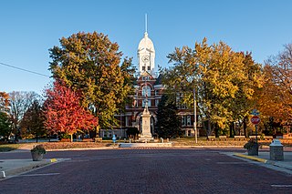
Taylor County is a county located in the U.S. state of Iowa. As of the 2020 census, the population was 5,896, making it the fourth-least populous county in Iowa. The county seat is Bedford. The county was formed in 1847 and named after General and President Zachary Taylor.

<span class="mw-page-title-main">Lenox, Iowa</span> City in Iowa, United States

Lenox is a city in Taylor and Adams counties in the U.S. state of Iowa. The population was 1,339 at the time of the 2020 census.

<span class="mw-page-title-main">Harpers Ferry, Iowa</span> City in Iowa, United States

Harpers Ferry is a city in Taylor Township, Allamakee County, Iowa, United States. The population was 262 at the time of the 2020 census.

<span class="mw-page-title-main">Udell, Iowa</span> City in Iowa, United States

Udell is a city in Appanoose County, Iowa, United States. The population was 28 at the time of the 2020 census.

<span class="mw-page-title-main">Allison, Iowa</span> City in Iowa, United States

Allison is a city in, and the county seat of, Butler County, Iowa, United States. The population was 966 at the 2020 census. Allison is home to the Butler County Fair. The city was named for U.S. Senator William B. Allison in 1881.

<span class="mw-page-title-main">Nashua, Iowa</span> City in Iowa, United States

Nashua is a city in Chickasaw County and Floyd County, Iowa. As of the 2020 census, the city's population was 1,551 a 6.7% decrease from 2010. The famed Little Brown Church featured in the song "The Church in the Wildwood" is located in Nashua.

<span class="mw-page-title-main">Protivin, Iowa</span> City in Iowa, United States

Protivin is a city in Chickasaw and Howard counties in the U.S. state of Iowa. The population was 269 at the time of the 2020 census. Early settlers named the city after the Bohemian town of Protivín in what is now the south of the Czech Republic. The current mayor of Protivin is Michael Lensing.

<span class="mw-page-title-main">Andover, Iowa</span> City in Iowa, United States

Andover is a city in Clinton County, Iowa, United States. The population was 109 at the 2020 census.

<span class="mw-page-title-main">Shueyville, Iowa</span> City in Iowa, United States

Shueyville is a city in Johnson County, Iowa, United States. It is part of the Iowa City, Iowa Metropolitan Statistical Area. The population was 731 at the time of the 2020 census.

<span class="mw-page-title-main">Solon, Iowa</span> City in Iowa, United States

Solon is a city located in Johnson County, Iowa, United States. Part of the Iowa City, Iowa Metropolitan Statistical Area, it is located a few miles from Lake MacBride State Park and the larger cities of Coralville and Iowa City. The population was 3,018 at the time of the 2020 census.

<span class="mw-page-title-main">Wapello, Iowa</span> City in Iowa, United States

Wapello is a city in and the county seat of Louisa County, Iowa, United States. The population was 2,084 at the time of the 2020 census.

<span class="mw-page-title-main">Blockton, Iowa</span> City in Iowa, United States

Blockton is a city in Taylor County, Iowa, United States. The population was 125 at the 2020 census.

<span class="mw-page-title-main">Conway, Iowa</span> City in Iowa, United States

Conway is a city in Taylor County, Iowa, United States. The population was 17 at the 2020 census.

<span class="mw-page-title-main">Gravity, Iowa</span> City in Iowa, United States

Gravity is a city in Taylor County, Iowa, United States. The population was 154 at the time of the 2020 census.

<span class="mw-page-title-main">New Market, Iowa</span> City in Iowa, United States

New Market is a city in Taylor County, Iowa, United States. The population was 385 at the time of the 2020 census.

<span class="mw-page-title-main">Sharpsburg, Iowa</span> City in Iowa, United States

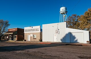
Sharpsburg is a city in Taylor County, Iowa, United States. The population was 72 at the time of the 2020 census.

<span class="mw-page-title-main">Cumming, Iowa</span> City in Iowa, United States

Cumming is a city in Warren County, Iowa, United States. The population was 436 at the time of the 2020 census. It is the hometown of former Senator Tom Harkin.

<span class="mw-page-title-main">North English, Iowa</span> City in Iowa, United States

North English is a city located mainly in Iowa county with a small portion in Keokuk county in the U.S. state of Iowa. The population was 1,065 at the time of the 2020 census. It is named for the English River.

<span class="mw-page-title-main">Bevington, Iowa</span> City in Iowa, United States

Bevington is a city in Madison and Warren Counties in the U.S. state of Iowa. The population was 57 at the 2020 census. It is part of the Des Moines–West Des Moines Metropolitan Statistical Area.

<span class="mw-page-title-main">Clearfield, Iowa</span> City in Iowa, United States

Clearfield is a city in Taylor and Ringgold counties in the U.S. state of Iowa. The population was 278 at the time of the 2020 census.

References

  1. "2020 U.S. Gazetteer Files". United States Census Bureau. Retrieved March 16, 2022.
  2. 1 2 U.S. Geological Survey Geographic Names Information System: Bedford, Iowa
  3. 1 2 "2020 Census State Redistricting Data". census.gov. United states Census Bureau. Retrieved August 12, 2021.
  4. "Find a County". National Association of Counties. Archived from the original on July 12, 2012. Retrieved June 7, 2011.
  5. "- Thomas J. Bedford profile - xphomestation.com". Archived from the original on March 9, 2009. Retrieved February 19, 2009.
  6. How Bedford Got Its Name - Bedford Centennial - 1953
  7. A Century Ago - Bedford Centerial - 1953
  8. Walker, James V. (2012). "Historical Atlas of the North American Railroad by Derek HayesHistorical Atlas of the American West by Derek Hayes". Oregon Historical Quarterly. 113 (2): 257–258. doi:10.1353/ohq.2012.0068. ISSN   2329-3780.
  9. RM Technologies, Inc. d/b/a/ Rand McNally; 2022 Road Atlas; p.28; 2021 (2021). Rand McNally 2022 Road Atlas of the United States, Canada, Mexico. Rand McNally. p. 28.{{cite book}}: CS1 maint: multiple names: authors list (link)
  10. "US Gazetteer files 2010". United States Census Bureau. Archived from the original on January 25, 2012. Retrieved May 11, 2012.
  11. "U.S. Climate Normals Quick Access". National Oceanic and Atmospheric Administration. Retrieved July 23, 2022.
  12. "NOAA Online Weather Data". National Weather Service. Retrieved July 23, 2022.
  13. "Census of Population and Housing". Census.gov. Retrieved June 4, 2015.
  14. "U.S. Census website". United States Census Bureau . Retrieved May 11, 2012.
  15. "U.S. Census website". United States Census Bureau . Retrieved January 31, 2008.
  16. "Bedford Archived 2018-04-27 at the Wayback Machine ." Iowa Department of Education. Retrieved on June 20, 2018.