Vinton, Iowa | |
---|---|
Coordinates: 42°9′51″N92°1′34″W / 42.16417°N 92.02611°W | |
Country | United States |
State | Iowa |
County | Benton |
Area | |
• Total | 4.97 sq mi (12.88 km2) |
• Land | 4.88 sq mi (12.65 km2) |
• Water | 0.09 sq mi (0.22 km2) |
Elevation | 787 ft (240 m) |
Population (2020) | |
• Total | 4,938 |
• Density | 1,010.85/sq mi (390.32/km2) |
Time zone | UTC-6 (Central (CST)) |
• Summer (DST) | UTC-5 (CDT) |
ZIP code | 52349 |
Area code | 319 |
FIPS code | 19-81210 |
GNIS feature ID | 0462580 |
Website | www |
Vinton is a city in Benton County, Iowa, United States. The population was 4,938 in the 2020 census, a decrease from 5,102 in 2000. [2] It is also part of the Cedar Rapids Metropolitan Statistical Area. Vinton is the county seat of Benton County. [3]
Vinton was founded in 1849. [4] It was named for Hon. Plynn Vinton, a state legislator. [5] The first railroad line was extended to Vinton in 1869, and it was incorporated as a city that same year. [6]
In 2022, the library in Vinton closed for a short period of time after employees quit for political reasons following complaints and allegations by patrons that included: the head librarian's "hiring and support for LGBTQ+ staff"; books by Jill Biden and Kamala Harris, and none about Donald Trump; "LGBTQ-themed book displays in the children’s section"; and male staff members "wearing dresses". [7] [8] [9] One of the library's former directors said they had 173 books about Christian life, and seven books about "LGBT, gay or transgender" topics; [10] another former director said some patrons "would check out the books and not return them", rather than file written complaints about the books. [10]
According to the United States Census Bureau, the city has a total area of 4.83 square miles (12.51 km2), of which 4.74 square miles (12.28 km2) is land and 0.09 square miles (0.23 km2) is water. [11]
Vinton is located on U.S. Route 218 and the Cedar River, which has flooded parts of the city, most recently in 2008. The town's extensive tree cover was damaged by a derecho (straight line windstorm) on July 11, 2011.
This region experiences significant seasonal temperature fluctuations, going from warm summers to very cold winters. There is precipitation year-round, and snowfall occurs in almost all years. Most summer rainfall occurs during thunderstorms and a very occasional tropical system. This area is classified as humid because it is not dry enough to be classified as semi-arid or arid. [12]
Climate data for Vinton, Iowa, 1991–2020 normals, extremes 1904–present | |||||||||||||
---|---|---|---|---|---|---|---|---|---|---|---|---|---|
Month | Jan | Feb | Mar | Apr | May | Jun | Jul | Aug | Sep | Oct | Nov | Dec | Year |
Record high °F (°C) | 63 (17) | 72 (22) | 88 (31) | 91 (33) | 95 (35) | 101 (38) | 105 (41) | 104 (40) | 100 (38) | 94 (34) | 80 (27) | 73 (23) | 105 (41) |
Mean maximum °F (°C) | 47.5 (8.6) | 53.4 (11.9) | 69.8 (21.0) | 81.1 (27.3) | 87.0 (30.6) | 91.3 (32.9) | 92.5 (33.6) | 90.8 (32.7) | 88.9 (31.6) | 82.4 (28.0) | 67.2 (19.6) | 52.4 (11.3) | 94.0 (34.4) |
Mean daily maximum °F (°C) | 25.6 (−3.6) | 30.4 (−0.9) | 44.4 (6.9) | 58.7 (14.8) | 69.4 (20.8) | 78.3 (25.7) | 81.4 (27.4) | 79.3 (26.3) | 73.5 (23.1) | 60.2 (15.7) | 44.2 (6.8) | 31.0 (−0.6) | 56.4 (13.5) |
Daily mean °F (°C) | 16.9 (−8.4) | 21.3 (−5.9) | 34.1 (1.2) | 46.8 (8.2) | 58.0 (14.4) | 67.5 (19.7) | 70.8 (21.6) | 68.5 (20.3) | 61.5 (16.4) | 48.8 (9.3) | 34.7 (1.5) | 22.7 (−5.2) | 46.0 (7.8) |
Mean daily minimum °F (°C) | 8.1 (−13.3) | 12.3 (−10.9) | 23.8 (−4.6) | 34.9 (1.6) | 46.6 (8.1) | 56.6 (13.7) | 60.2 (15.7) | 57.7 (14.3) | 49.5 (9.7) | 37.3 (2.9) | 25.2 (−3.8) | 14.5 (−9.7) | 35.6 (2.0) |
Mean minimum °F (°C) | −13.4 (−25.2) | −8.3 (−22.4) | 3.9 (−15.6) | 21.8 (−5.7) | 33.6 (0.9) | 46.0 (7.8) | 52.0 (11.1) | 49.5 (9.7) | 35.9 (2.2) | 22.9 (−5.1) | 9.7 (−12.4) | −5.5 (−20.8) | −17.7 (−27.6) |
Record low °F (°C) | −35 (−37) | −32 (−36) | −34 (−37) | 4 (−16) | 22 (−6) | 35 (2) | 42 (6) | 36 (2) | 22 (−6) | 10 (−12) | −10 (−23) | −27 (−33) | −35 (−37) |
Average precipitation inches (mm) | 1.19 (30) | 1.25 (32) | 2.05 (52) | 3.90 (99) | 5.01 (127) | 5.62 (143) | 4.15 (105) | 4.22 (107) | 3.68 (93) | 3.22 (82) | 2.05 (52) | 1.59 (40) | 37.93 (962) |
Average snowfall inches (cm) | 8.3 (21) | 8.5 (22) | 4.4 (11) | 1.4 (3.6) | 0.0 (0.0) | 0.0 (0.0) | 0.0 (0.0) | 0.0 (0.0) | 0.0 (0.0) | 0.4 (1.0) | 1.8 (4.6) | 8.8 (22) | 33.6 (85.2) |
Average precipitation days (≥ 0.01 in) | 7.2 | 6.4 | 7.6 | 9.5 | 12.3 | 11.8 | 9.4 | 9.4 | 8.6 | 8.3 | 6.2 | 7.5 | 104.2 |
Average snowy days (≥ 0.1 in) | 5.1 | 4.4 | 2.2 | 0.7 | 0.0 | 0.0 | 0.0 | 0.0 | 0.0 | 0.2 | 1.0 | 4.4 | 18.0 |
Source 1: NOAA [13] | |||||||||||||
Source 2: National Weather Service [14] |
Year | Pop. | ±% |
---|---|---|
1870 | 2,460 | — |
1880 | 2,906 | +18.1% |
1890 | 2,865 | −1.4% |
1900 | 3,499 | +22.1% |
1910 | 3,336 | −4.7% |
1920 | 3,381 | +1.3% |
1930 | 3,372 | −0.3% |
1940 | 4,163 | +23.5% |
1950 | 4,307 | +3.5% |
1960 | 4,781 | +11.0% |
1970 | 4,845 | +1.3% |
1980 | 5,040 | +4.0% |
1990 | 5,103 | +1.2% |
2000 | 5,102 | −0.0% |
2010 | 5,257 | +3.0% |
2020 | 4,938 | −6.1% |
Iowa Data Center [15] Source: U.S. Decennial Census [16] [2] |
As of the census [17] of 2010, there were 5,257 people, 2,187 households, and 1,397 families residing in the city. The population density was 1,109.1 inhabitants per square mile (428.2/km2). There were 2,299 housing units at an average density of 485.0 per square mile (187.3/km2). The racial makeup of the city was 97.8% White, 0.3% African American, 0.2% Native American, 0.3% Asian, 0.2% from other races, and 1.2% from two or more races. Hispanic or Latino of any race were 1.0% of the population.
There were 2,187 households, of which 30.4% had children under the age of 18 living with them, 47.9% were married couples living together, 11.3% had a female householder with no husband present, 4.6% had a male householder with no wife present, and 36.1% were non-families. 31.0% of all households were made up of individuals, and 16.1% had someone living alone who was 65 years of age or older. The average household size was 2.33 and the average family size was 2.91.
The median age in the city was 40.3 years. 24.7% of residents were under the age of 18; 8.1% were between the ages of 18 and 24; 23.1% were from 25 to 44; 24.5% were from 45 to 64; and 19.5% were 65 years of age or older. The gender makeup of the city was 47.3% male and 52.7% female.
As of the census [18] of 2000, there were 5,102 people, 2,116 households, and 1,390 families residing in the city. The population density was 1,187.7 inhabitants per square mile (458.6/km2). There were 2,227 housing units at an average density of 518.4 per square mile (200.2/km2). The racial makeup of the city was 98.26% White, 0.25% African American, 0.18% Native American, 0.27% Asian, 0.02% Pacific Islander, 0.22% from other races, and 0.80% from two or more races. Hispanic or Latino of any race were 0.94% of the population.
There were 2,116 households, out of which 30.8% had children under the age of 18 living with them, 53.8% were married couples living together, 9.7% had a female householder with no husband present, and 34.3% were non-families. 29.9% of all households were made up of individuals, and 15.0% had someone living alone who was 65 years of age or older. The average household size was 2.34 and the average family size was 2.91.
25.0% are under the age of 18, 7.9% from 18 to 24, 27.3% from 25 to 44, 19.5% from 45 to 64, and 20.2% who were 65 years of age or older. The median age was 38 years. For every 100 females, there were 90.1 males. For every 100 females age 18 and over, there were 84.6 males.
The median income for a household in the city was $35,114, and the median income for a family was $41,546. Males had a median income of $32,460 versus $19,988 for females. The per capita income for the city was $19,808. About 9.5% of families and 9.8% of the population were below the poverty line, including 13.7% of those under age 18 and 6.0% of those age 65 or over.
The Vinton-Shellsburg Community School District operates public schools. The district was established on July 1, 1993, by the merger of the Vinton Community School District and the Shellsburg Community School District. [19]
Vinton was the home of the Iowa Braille and Sight Saving School, Iowa's state educational institution for vision-impaired students. [20]
Residing in the Braille School since 2008 is the North Central Region headquarters for AmeriCorps National Civilian Community Corps (NCCC). [21]
Portions of downtown Vinton, along with the Benton County courthouse, were featured in the 1996 John Travolta film Michael . Also seen during the movie's opening credits was Prairie Creek Church, a rural area Christian church located approximately six miles northeast of the city.
Portions of downtown Vinton were used in the movie "The Final Season".
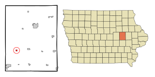
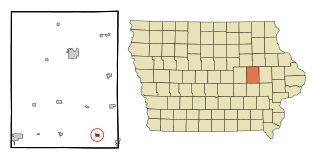
Ringgold County is a county located in the U.S. state of Iowa. As of the 2020 census, the population was 4,663, making it the Iowa county with the second-smallest population. The county seat is Mount Ayr. The county is named after Maj. Samuel Ringgold, a hero of the Battle of Palo Alto fought in May 1846, during the Mexican–American War. It is one of the 26 Iowa counties with a name that is unique across the nation.
Fremont County is a county located in the U.S. state of Iowa. As of the 2020 census the population was 6,605, making it the state's seventh-least populous county. The county seat is Sidney. The county was formed in 1847 and named for the military officer John C. Frémont.
Buchanan County is a county located in the U.S. state of Iowa. As of the 2020 census, the population was 20,565. Its county seat is Independence. The county was created in 1837 and was named in honor of Senator James Buchanan, the 15th President of the United States.
Benton County is a county in the U.S. state of Iowa. As of the 2020 census, the population was 25,575. Its county seat and largest city is Vinton. The county is named for Thomas Hart Benton, a U.S. Senator from Missouri.
Atkins is a city in Benton County, Iowa, United States. The population was 2,056 at the 2020 census. It is part of the Cedar Rapids Metropolitan Statistical Area.
Belle Plaine is a city in Benton County, Iowa, United States. The population was 2,330 at the 2020 census. It is part of the Cedar Rapids Metropolitan Statistical Area.
Blairstown is a city in Benton County, Iowa, United States. The population was 713 at the 2020 census. It is part of the Cedar Rapids Metropolitan Statistical Area.
Garrison is a city in Benton County, Iowa, United States. The population was 344 at the time of the 2020 census. It is part of the Cedar Rapids Metropolitan Statistical Area.
Keystone is a city in Benton County, Iowa, United States. The population was 599 at the time of the 2020 census. It is part of the Cedar Rapids Metropolitan Statistical Area.
Mount Auburn is a city in Benton County, Iowa, United States. The population was 162 at the time of the 2020 census. It is part of the Cedar Rapids Metropolitan Statistical Area.
Newhall is a city in Benton County, Iowa, United States. The population was 876 at the time of the 2020 census. It is part of the Cedar Rapids Metropolitan Statistical Area.
Norway is a city in Benton County, Iowa, United States. The population was 466 at the time of the 2020 census. The city is approximately 17 miles (27 km) southwest of downtown Cedar Rapids. It is part of the Cedar Rapids Metropolitan Statistical Area. Norway is the setting of the movie The Final Season.
Shellsburg is a city in Benton County, Iowa, United States. The population was 961 at the time of the 2020 census. It is part of the Cedar Rapids Metropolitan Statistical Area.
Van Horne is a city in Benton County, Iowa, United States. The population was 774 at the 2020 census. It is part of the Cedar Rapids Metropolitan Statistical Area.
Walford is a city in Benton and Linn counties in the U.S. state of Iowa. The population was 1,366 at the time of the 2020 census. It is part of the Cedar Rapids Metropolitan Statistical Area.
Dakota City is a city in and the county seat of Humboldt County, Iowa, United States. The population was 759 at the time of the 2020 census. Dakota City shares its western border with the much larger city of Humboldt. It is the least populous county seat in Iowa.
Benton is a city in Ringgold County, Iowa, United States. The population was 39 at the 2020 census.
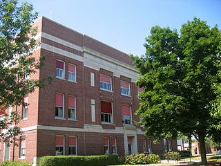
Mount Ayr is a city in Ringgold County, Iowa, United States. The population was 1,988 at the time of the 2020 census. It is the county seat of Ringgold County. Mount Ayr is a rural community in southwestern Iowa, 22 miles west of Interstate 35 on State Highway 2. Mount Ayr was founded in 1875 and the community was named in honor of poet Robert Burns’ birthplace in Ayr, Scotland. The “mount” was added to indicate its location on the highest point of land in the area.
Benton is a city in Scott County, Missouri, United States. The population was 863 at the 2010 census. It is the county seat of Scott County.
De Smet is a city in and the county seat of Kingsbury County, South Dakota, United States. The population was 1,056 at the 2020 census.