Bethpage, New York

Last updated

Bethpage, New York
Central Park
Welcome to Bethpage sign at LIRR Station.jpg
A welcome sign for the hamlet.
Nassau County New York incorporated and unincorporated areas Bethpage highlighted.svg
Location of Bethpage in Nassau County (right) and New York state (left)
USA New York location map.svg
Red pog.svg
Bethpage, New York
Coordinates: 40°44′48″N73°29′4″W / 40.74667°N 73.48444°W / 40.74667; -73.48444
Country Flag of the United States.svg  United States
State Flag of New York.svg  New York
County Flag of Nassau County, New York.svg  Nassau County, New York
Town Oyster Bay
Area
[1]
  Total3.58 sq mi (9.26 km2)
  Land3.58 sq mi (9.26 km2)
  Water0.00 sq mi (0.00 km2)
Elevation
105 ft (32 m)
Population
 (2020)
  Total16,658
  Density4,658.28/sq mi (1,798.67/km2)
Time zone UTC−5 (Eastern (EST))
  Summer (DST) UTC−4 (EDT)
ZIP Code
11714
Area code 516
FIPS code 36-06387
GNIS feature ID0943803

Bethpage (formerly known as Central Park) is a hamlet and census-designated place (CDP) located within the Town of Oyster Bay in Nassau County, on Long Island, in New York, United States. The population was 16,658 at the 2020 United States Census. [2]

Contents

History

The name Bethpage comes from the Quaker Thomas Powell, who named the area after the Biblical town Bethphage, which was between Jericho and Jerusalem in the Holy Land. Present-day Bethpage was part of the 1695 Bethpage Purchase. An early name for the northern section of present-day Bethpage was Bedelltown, [3] [4] a name that appeared on maps at least as late as 1906. [5]

On maps just before the arrival of the Long Island Rail Road (LIRR), the name Bethpage appears for a community now included in both the post office district and school district of the adjacent community of Farmingdale. [6] In 1841, [7] train service began to Farmingdale station, near a new settlement less than a mile eastward from what had previously appeared on maps as Bethpage. Schedules at that time do not mention Bethpage as a stop, but have a notation "late Bethpage". [8] On an 1855 map, [9] the location identified as Bethpage has shifted slightly westward to include a nearby area now called Plainedge.

Between 1851 [10] and 1854, [11] the LIRR initiated a stop within present-day Bethpage at a station then called Jerusalem Station, and on January 29, 1857, a local post office opened, also named Jerusalem Station. [12] [13] LIRR schedules listed the station also as simply Jerusalem. [14] [15] Residents succeeded in changing the name of the post office to Central Park, effective March 1, 1867 (respelled as Centralpark from 1895 to 1899). [12] [16] The Central Park Fire Company was organized in April 1910, and incorporated in May 1911. In May 1923 the Central Park Water District was created.

Following the 1932 opening of nearby Bethpage State Park, the name of the local post office was changed to Bethpage on October 1, 1936. The LIRR station was also renamed Bethpage station. The name Bethpage was, however, already in use by an adjacent community, [3] which resisted suggestions of a merger and instead renamed itself Old Bethpage. The change from Central Park to Bethpage was one of the last complete name changes of Nassau County's post offices. [12]

From 1936 until 1994, Bethpage was home to the Grumman Aircraft Engineering Corporation, which made, among other things, the F-14 Tomcat, the Navy version of the General Dynamics F-111 Aardvark and the Apollo Lunar Excursion Module (LEM) for Moon landings, and for this reason Bethpage is mentioned in the 1995 film Apollo 13 . Grumman was made famous by the performance of its F4F Wildcat fighter aircraft and its successor the F6F Hellcat, which shot down 5,223 enemy aircraft, more than any other naval aircraft. In 1994, Grumman was purchased by Northrop and formed Northrop Grumman. Although no longer headquartered in Bethpage, the company still retains operations there. [17]

The Naval Weapons Industrial Reserve Plant, Bethpage (NWIRP) started operations in 1942, west of the Grumman site. [18]

Altice USA (f/k/a Cablevision) is headquartered in Grumman's former main office.

In August 2015, a small airplane with engine trouble failed to reach Farmingdale airport, and was redirected to "Bethpage Airport" by the air traffic controller. However, the pilot could not find that airport because it was closed and had buildings on it, and the plane crashed on LIRR tracks. [19] [20]

Superfund site

Bethpage's history as a space and aviation center has left heavy metals, toxic waste, and radioactive [21] byproducts dumped into the surrounding ground and leeching into the water. Bethpage as of 2012 has been declared a class 2 Superfund site. [22] The rate of cancers and birth defects in Bethpage is statistically well above the national average, which many attribute to the polluted soil and ground water. [23] [24] Bethpage residents have taken action by filing a $500 million lawsuit against Grumman. [25]

Geography

U.S. Census map of Bethpage. Bethpage-ny-map.png
U.S. Census map of Bethpage.

According to the United States Census Bureau, the CDP, or Census Designated Place, has a total area of 3.6 square miles (9.3 km2), all land. For the 2000 Census, the boundaries of the CDP were adjusted compared to those of the 1990 census, with some territory gained and some lost. [26]

The area is served by the Bethpage Post Office, ZIP code 11714, whose boundaries are slightly different from that of the CDP. The area is also served by Bethpage Union Free School District, Island Trees Union Free School District, Plainedge Union Free School District, and Hicksville Union Free School District, the boundaries of which include parts of some surrounding hamlets, including parts of Old Bethpage, Plainview, and Plainedge. The Town of Hempstead, on its website, includes a small part of Bethpage hamlet that is in the Levittown census-designated place. [27]

Economy

Bethpage Business Park. Bethpage Business Park.jpg
Bethpage Business Park.

The grocery chain King Kullen is based in Bethpage. USPS also has a sorting facility in the town that serves the New York region. Bethpage is also home to the North America Headquarters of technology company LogiTag and Altice, formerly known as Cablevision.

Bethpage is home to two movie studios. [28] Gold Coast Studios has filmed major motion pictures in Bethpage including The Amazing Spider-Man 2 [29] and Sisters , [30] as well as the television series Pan Am [31] and Kevin Can Wait . [32] Grumman Studios also worked on The Amazing Spider-Man 2, [29] and has filmed Avengers , [33] Salt [34] and broadcast The Sound of Music Live! [35]

Goya Foods has its Long Island division in Bethpage. [36]

Demographics

Historical population
CensusPop.Note
2000 16,543
2010 16,429−0.7%
2020 16,6581.4%
U.S. Decennial Census [37]
Historical Population [38]
Year
Population
1903306
1909530
19301,888
19402,590
196015,840
197018,550
198016,846
199015,761
200016,543
201016,429
202016,658

2010 census

As of the census of 2010, [39] there were 16,429 people, 5,710 households, and 4,516 families residing in the CDP. The population density was 4,564.5 inhabitants per square mile (1,762.4/km2). There were 5,788 housing units at an average density of 1,597.0 per square mile (616.6/km2). The racial makeup of the CDP was 90.8% White 85.8% Non-Hispanic White, 0.6% African American, 0.1% Native American, 5.5% Asian, 1.5% from other races, and 1.4% from two or more races. Hispanic or Latino of any race were 7% of the population. [2]

There were 5,710 households, out of which 32% had children under the age of 18 living with them, 66.0% were married couples living together, 10.0% had a female householder with no husband present, and 20.9% were non-families. Of all households 17.9% were made up of individuals, and 11.3% had someone living alone who was 65 years of age or older. The average household size was 2.89 and the average family size was 3.27. [2]

In the CDP, the population was spread out, with 22.7% under the age of 18, 6.4% from 18 to 24, 29.0% from 25 to 44, 23.2% from 45 to 64, and 18.8% who were 65 years of age or older. The median age was 40 years. For every 100 females, there were 93.0 males. For every 100 females age 18 and over, there were 88.8 males. [2]

The median income for a household in the CDP was $70,173, and the median income for a family was $78,573. Males had a median income of $53,404 versus $36,708 for females. The per capita income for the CDP was $27,850. About 2.1% of families and 3.3% of the population were below the poverty line, including 4.0% of those under age 18 and 4.3% of those age 65 or over. [2]

Arts and culture

Bethpage was the home of the Grumman plant that produced the Apollo Lunar Modules, or LEMs.

Bethpage State Park offers five golf courses to choose from. One of them, the Black Course, was the site of the U.S. Open in 2002 and 2009. Tiger Woods won the event in 2002 and Lucas Glover in 2009. While the park and its five golf courses are located almost entirely within Old Bethpage and its offices are located within the neighboring Farmingdale postal district, it is easily accessed from Bethpage.

Bethpage Water District was announced as the best tasting drinking water in New York State at the New York State Fair in Syracuse in 2006. [40] In 2010 chlorine was added to the drinking water following new Nassau County Board of Health regulations, leading many residents to complain that the taste of the water had declined. [41]

Medal of Honor recipient Stephen Edward Karopczyc lived in Bethpage, [42] and the former Karopczyc School in Bethpage (part of the Island Trees Union Free School District) was renamed for him. The school now houses the Island Trees Public Library.

The Town of Oyster Bay Ice Skating Center in Bethpage has an NHL-size rink for skating, and is home to the Long Island Blues special hockey team, who practice and play home games at the rink. [43] [44]

Education

The main entrance to Bethpage High School Bethpagesrhs.jpg
The main entrance to Bethpage High School

Bethpage residents can be zoned for the Bethpage Union Free School District, the Plainedge Union Free School District, the Island Trees Union Free School District, or the Hicksville Union Free School District. [45]

Additionally, Briarcliffe College used to have a campus in Bethpage. [46]

Notable people

Related Research Articles

<span class="mw-page-title-main">Nassau County, New York</span> County in New York, United States

Nassau County is a suburban county located immediately to the east of New York City. As of the 2020 United States census, Nassau County's population was 1,395,774, making it the sixth-most populous county in the State of New York, and reflecting an increase of 56,242 (+4.2%) from the 1,339,532 residents enumerated at the 2010 census. Its county seat is Mineola, while the county's largest town is Hempstead. The county is part of the Long Island region of the state, lying in its southeastern portion along with the remainder of the island.

<span class="mw-page-title-main">Farmingdale, New York</span> Village in New York, United States

Farmingdale is an incorporated village on Long Island within the Town of Oyster Bay in Nassau County, New York, United States. The population was 8,466 at the time of the 2020 Census.

<span class="mw-page-title-main">Hicksville, New York</span> Hamlet and census-designated place in New York, United States

Hicksville is a hamlet and census-designated place (CDP) within the Town of Oyster Bay in Nassau County, on Long Island, in New York. The population of the CDP was 43,869 at the 2020 census.

<span class="mw-page-title-main">Old Bethpage, New York</span> Hamlet and census-designated place in New York, United States

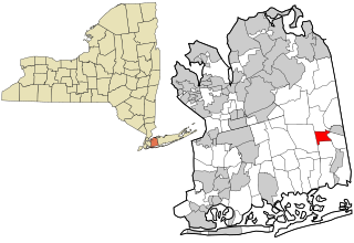
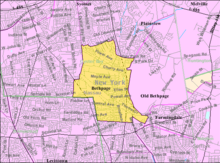
Old Bethpage is a hamlet and census-designated place (CDP) located on Long Island in the Town of Oyster Bay, Nassau County, New York, United States. The population of the CDP was 5,283 at the 2020 United States Census. It is served by the Old Bethpage Post Office, ZIP code 11804.

<span class="mw-page-title-main">Plainedge, New York</span> Hamlet and census-designated place in New York, United States

Plainedge is a hamlet and census-designated place (CDP) in the Town of Oyster Bay in Nassau County, on Long Island, in New York, United States. The population was 8,817 at the 2010 census.

<span class="mw-page-title-main">Plainview, New York</span> Populated place in Nassau County, New York, US

Plainview is a hamlet and census-designated place (CDP) located near the North Shore of Long Island in the town of Oyster Bay in Nassau County, New York, United States. The population of the CDP as of 2020 was 27,100. The Plainview post office has the ZIP code 11803.

<span class="mw-page-title-main">South Farmingdale, New York</span> Hamlet and census-designated place in New York, United States

South Farmingdale is a hamlet and census-designated place (CDP) in the Town of Oyster Bay in Nassau County, on the South Shore of Long Island, in New York, United States. It is considered part of the Greater Farmingdale area, which is anchored by Farmingdale. The population of the CDP was 14,345 at the 2020 census.

<span class="mw-page-title-main">Wyandanch, New York</span> Hamlet and census-designated place in New York, United States

Wyandanch is a hamlet and census-designated place (CDP) in the Town of Babylon in Suffolk County, New York. The population was 12,990 at the 2020 census.

<span class="mw-page-title-main">New York State Route 24</span> Highway in New York

New York State Route 24 (NY 24) is a 30.84-mile-long (49.63 km) east–west state highway on Long Island in the U.S. state of New York. The highway is split into two segments, with the longer and westernmost of the two extending 18.68 miles (30.06 km) from an interchange with Interstate 295 and NY 25 in the Queens Village section of the New York City borough of Queens to an intersection with NY 110 in East Farmingdale in the Suffolk County town of Babylon. The shorter eastern section, located in eastern Suffolk County, extends 12.16 miles (19.57 km) from an interchange with I-495 in Calverton to an intersection with County Route 80 (CR 80) in Hampton Bays.

<span class="mw-page-title-main">Hicksville station</span> Long Island Rail Road station in Nassau County, New York

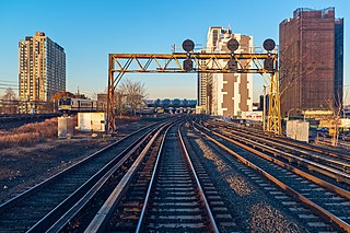
Hicksville is a station on the Main Line and Port Jefferson Branch of the Long Island Rail Road located in Hicksville, New York. It is the busiest station east of Jamaica and Penn Station by combined weekday/weekend ridership.

<span class="mw-page-title-main">Ronkonkoma Branch</span> Long Island Rail Road branch

The Ronkonkoma Branch is a rail service operated by the Long Island Rail Road (LIRR) in the U.S. state of New York. On LIRR maps and printed schedules, the "Ronkonkoma Branch" includes trains running along the railroad's Main Line from Hicksville to Ronkonkoma, and between Ronkonkoma and the Main Line's eastern terminus at Greenport. The section of the Main Line east of Ronkonkoma is not electrified and is referred to as the Greenport Branch.

<span class="mw-page-title-main">Central Branch (Long Island Rail Road)</span> Long Island Rail Road branch

The Central Branch is a rail line owned and operated by the Long Island Rail Road (LIRR) in the U.S. state of New York, extending from 40.734°N 73.470°W just east of Bethpage station to 40.696°N 73.341°W just west of Babylon station. It was built in 1873 as part of the Babylon Extension of the Central Railroad of Long Island (CRRLI), which was owned by Alexander Turney Stewart. The branch was mostly unused following the 1876 merger of the CRRLI and the LIRR, but in 1925 it was rebuilt and reconfigured to connect Bethpage and Babylon stations.

<span class="mw-page-title-main">Main Line (Long Island Rail Road)</span> Long Island Rail Road branch

The Main Line is a rail line owned and operated by the Long Island Rail Road in the U.S. state of New York. It begins as a two-track line at Long Island City station in Long Island City, Queens, and runs along the middle of Long Island about 95 miles (153 km) to Greenport station in Greenport, Suffolk County. At Harold Interlocking approximately one mile east of Long Island City, the tracks from the East River Tunnels and 63rd Street Tunnel into Manhattan intersect with the Main Line, which most trains use rather than using the Long Island City station.

<span class="mw-page-title-main">Bethpage station</span> Long Island Rail Road station in Nassau County, New York

Bethpage is a station along the Main Line of the Long Island Rail Road. It is located at Stewart Avenue and Jackson Avenue, in Bethpage, New York, and serves Ronkonkoma Branch trains. Trains that travel along the Central Branch also use these tracks, but do not stop here.

<span class="mw-page-title-main">Farmingdale station</span> Long Island Rail Road station in Nassau County, New York

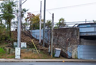
Farmingdale is a historic railroad station in Farmingdale, New York, along the Main Line of the Long Island Rail Road. It is located just east of Secatogue Avenue, on South Front Street and Atlantic Avenue. The station has two platforms, with an underground pedestrian walkway connecting them. The station house is on the south platform. Parking is available on both sides of the tracks.

The Bethpage Purchase was a 1687 land transaction in which Thomas Powell, Sr, bought more than 15 square miles in central Long Island, New York, for £140 from local Indian tribes, including the Marsapeque, Matinecoc, and Sacatogue. This land, which includes present day Bethpage, East Farmingdale, Farmingdale, Old Bethpage, Plainedge, Plainview, South Farmingdale, and part of Melville, is approximately 3.5 miles (5.6 km) east to west and 5 mi (8.0 km) north to south, covering land on both sides of the present-day border between Nassau and Suffolk counties.

<span class="mw-page-title-main">Garden City–Mitchel Field Secondary</span> Long Island Rail Road branch

The Garden City–Mitchell Field Secondary is a lightly used freight branch of the Long Island Rail Road. It is a spur off the Hempstead Branch.

Central Railroad of Long Island was built on Long Island, New York, by Alexander Turney Stewart, who was also the founder of Garden City. The railroad was established in 1871, then merged with the Flushing and North Side Railroad in 1874 to form the Flushing, North Shore and Central Railroad. It was finally acquired by the Long Island Rail Road in 1876 and divided into separate branches. Despite its short existence, the CRRLI had a major impact on railroading and development on Long Island.

<span class="mw-page-title-main">Republic station</span>

Republic was a station stop along the Ronkonkoma Branch which served employees of the Fairchild Engine & Airplane Manufacturing Company and the nearby Republic Airport from 1940 to the late 1980s. As part of a double-tracking project on the line, the station may be reopened.

Grumman was a station along the Main Line of the Long Island Rail Road (LIRR) at South Oyster Bay Road that served employees of Grumman Engineering Aircraft Corporation, at the Grumman Bethpage Airport.

References

  1. "ArcGIS REST Services Directory". United States Census Bureau. Retrieved September 20, 2022.
  2. 1 2 3 4 5 "U.S. Census website". United States Census Bureau . Retrieved 2008-01-31.
  3. 1 2 "1873 map of Town of Oyster Bay". New York Public Library. Retrieved April 7, 2008.
  4. "LIRR timeline: 1898 map used as background". Archived from the original on December 15, 2001.{{cite web}}: CS1 maint: unfit URL (link)
  5. "1906 map of Central Nassau County" . Retrieved April 30, 2011.
  6. W.W. Mather (c. 1842). "Geological map of Long & Staten islands with the environs of New York". New York Public Library.[ permanent dead link ] (The location marked Bethpage is near Merritts Road, just north of Hempstead Turnpike. An unbounded area further east in Suffolk County is marked Hardscrabble. The map is dated 1842 with a question mark. Neither Farmingdale nor Hicksville appears on the map. The Hicksville LIRR station opened in 1837, and its absence suggests an earlier date for the map. The LIRR also had taken a different route east of Hicksville, arriving in Farmingdale in 1841.)
  7. "Early LIRR History". Archived from the original on March 4, 2000.{{cite web}}: CS1 maint: unfit URL (link)
  8. "1841 Brooklyn Eagle LIRR timetable". Brooklyn Eagle. November 2, 1841. Archived from the original on June 12, 2011. (Whether "late Bethpage" is meant to indicate a flag stop at the community near Merritts Road, or that the area near the Farmingdale LIRR station had lately been called Bethpage has not yet been determined.)
  9. "1855 Colton map".
  10. "1851 schedule without Bethpage". Archived from the original on August 29, 2000.{{cite web}}: CS1 maint: unfit URL (link)
  11. "Railroads". The New York Times. April 13, 1854. p. 7. Retrieved April 7, 2008.
  12. 1 2 3 Roberts, David. "Nassau County Post Offices 1794–1879" . Retrieved May 26, 2019.John L. Kay & Chester M. Smith, Jr. (1982). New York Postal History: The Post Offices & First Postmasters from 1775 to 1980. American Philatelic Society.
  13. Jerusalem was a community to the south, now called Wantagh. One of the reasons later given for changing the name from Jerusalem Station was that residents wanted to establish an identity of their own that did not depend on their being a station for another community.
  14. "1863 LIRR timetable" . Retrieved April 7, 2008.
  15. The schedule shows the stop is 2 miles from Farmingdale and 3 miles from Hicksville, the same distances for the existing Bethpage LIRR station as of 2024.
  16. Central Park in Manhattan had opened in 1859.
  17. "Northrop Grumman in Bethpage, New York" . Retrieved October 25, 2021.
  18. "RECORD OF DECISION Northrop Grumman" (PDF). www.dec.gov. March 2013. Retrieved April 9, 2014.
  19. Editorial Staff (August 25, 2015). "NTSB Says ATC Directed Pilot In Distress To Closed Airport". AVweb. Retrieved August 31, 2021.
  20. "Aviation Accident".
  21. "Governor Cuomo Orders Engineering Investigation to Expedite Containment of Long Island Groundwater Plumes".
  22. "DEC Outlines Remediation Plan For Bethpage Plume". Antonnews.com. June 29, 2012. Archived from the original on August 10, 2014. Retrieved August 3, 2014.
  23. "Blog Series: Letters to Grumman from the Bethpage Community, Part I". Bethpage Cancer Project. Archived from the original on August 8, 2014. Retrieved August 3, 2014.
  24. "Hazardous Waste Site Classification".
  25. Dooley, Emily. "Bethpage Residents File $500M Lawsuit Against Northrop Grumman". Newsday. Retrieved December 12, 2018.
  26. "New York: 2000 Population and Housing Unit Counts" (PDF). September 2003. p. III-9. Retrieved December 22, 2010.
  27. "Town of Hempstead Map". Archived from the original on January 18, 2008. Retrieved 2008-01-16.
  28. Phillips, Ted (May 14, 2020). "LI's TV, film industry looks to post-shutdown future". Newsday. Retrieved May 15, 2020.
  29. 1 2 Du, Lisa (March 12, 2013). "'Spider-Man' sequel to film at Bethpage studios". Newsday. Retrieved May 15, 2020.
  30. Lovece, Frank (December 17, 2015). "8 LI locales where Fey, Poehler shot 'Sisters'". Newsday. Retrieved May 15, 2020.
  31. Christ, Lindsay (March 23, 2011). "Christina Ricci Films ABC's 'Pan Am' on Long Island | Long Island Press". archive.longislandpress.com. Long Island Press. Retrieved May 15, 2020.
  32. Sacks, Ethan (September 18, 2016). "'Kevin Can Wait' brings Kevin James home in Long Island's first sitcom". nydailynews.com. Daily News. Retrieved May 15, 2020.
  33. Lovece, Frank (October 19, 2010). "'Avengers' being shot at Grumman Studios". Newsday. Retrieved May 15, 2020.
  34. "Angelina Jolie Lands at Grumman Studios". Grumman Studios. January 15, 2009. Archived from the original on February 12, 2011.
  35. "'The Sound of Music' airs live from Grumman Studios on Long Island". longisland.news12.com. news12 Long Island. December 6, 2013. Retrieved May 15, 2020.
  36. "Contact Us Archived April 24, 2011, at the Wayback Machine ." Goya Foods. Retrieved on March 26, 2016. "Goya Foods of Long Island 201 Grumman Road West Bethpage, NY 11714"
  37. "Census of Population and Housing". Census.gov. Retrieved June 4, 2016.
  38. "Encyclopedia of the Unincorporated Village of Bethpage". January 21, 2006. Archived from the original on August 30, 2008. Retrieved April 20, 2012.
  39. United States Census
  40. "Town of Oyster Bay Ice Skating Rinks". Archived February 27, 2012, at the Wayback Machine .
  41. Schwartz, David M.; LaRocco, Paul (February 18, 2020). "In proud Bethpage, years of worry take emotional toll". Newsday.
  42. "Medal of Honor.com- Stephen E. Karopczyc". Archived from the original on October 22, 2006. Retrieved January 25, 2007.
  43. Archived March 25, 2014, at the Wayback Machine
  44. "Long Island Blues Hockey Club powered by GOALLINE.ca". Longislandblues.org. Retrieved August 3, 2014.
  45. "Long Island Index: Interactive Map". www.longislandindexmaps.org. Retrieved November 9, 2021.
  46. "Briarcliffe College is Long Island's hottest college for business, technology and graphic design". September 14, 2002. Archived from the original on September 14, 2002. Retrieved November 9, 2021.