Parts of this article (those related to Demographics) need to be updated.(October 2022) |
Point Lookout, New York | |
---|---|
Coordinates: 40°35′27″N73°34′48″W / 40.59083°N 73.58000°W | |
Country | United States |
State | New York |
County | Nassau |
Town | Hempstead |
Area | |
• Total | 0.38 sq mi (0.97 km2) |
• Land | 0.27 sq mi (0.70 km2) |
• Water | 0.10 sq mi (0.27 km2) |
Elevation | 3 ft (1 m) |
Population (2020) | |
• Total | 1,527 |
• Density | 5,634.69/sq mi (2,175.16/km2) |
Time zone | UTC−5 (Eastern (EST)) |
• Summer (DST) | UTC−4 (EDT) |
ZIP Code | 11569 |
Area codes | 516, 363 |
FIPS code | 36-58849 |
GNIS feature ID | 0960827 |
Point Lookout is a hamlet and census-designated place (CDP) located in the town of Hempstead in Nassau County, New York, United States. The population was 1,527 at the time of the 2020 census. [2] The town is mostly made up of residential homes, with several small businesses on Lido Boulevard. The town is surrounded on three sides by water. Today, Point Lookout has become a popular location for summer residences. Among its inhabitants, it is commonly referred to as "PLO".
Point Lookout is located at the east end of Long Beach Barrier Island. It is adjacent to Lido Beach, which in turn abuts the city of Long Beach, to the west. Point Lookout covers a total area of 0.2 square miles (0.52 km2), all land.
Long Beach Barrier Island, which lies between Reynolds Channel and the Atlantic Ocean, was originally formed by glacial deposits [3] and includes a variety of bays, dunes, ponds, marshes, and ocean shoreline, which supports a complex ecosystem that includes a wide variety of flora and fauna. Jones Inlet separates it from Jones Beach Island. [4]
Census | Pop. | Note | %± |
---|---|---|---|
2020 | 1,527 | — | |
U.S. Decennial Census [5] |
This section needs to be updated.(October 2022) |
At the time of the census [6] of 2000, there were 1,472 people, 616 households, and 413 families residing in the CDP. The population density was 7,379.7 inhabitants per square mile (2,849.3/km2). There were 792 housing units at an average density of 3,970.6 per square mile (1,533.1/km2). The racial makeup of the CDP was 97.42% White, 0.41% African American, 0.48% Asian, 0.88% from other races, and 0.82% from two or more races. Hispanic or Latino of any race were 2.11% of the population.
There were 616 households, out of which 25.8% had children under the age of 18 living with them, 53.9% were married couples living together, 10.9% had a female householder with no husband present, and 32.8% were non-families. Of all households, 26.9% were made up of individuals, and 12.2% had someone living alone who was 65 years of age or older. The average household size was 2.39 and the average family size was 2.91.
The population was spread out, with 20.8% under the age of 18, 5.6% from 18 to 24, 26.0% from 25 to 44, 29.6% from 45 to 64, and 18.0% who were 65 years of age or older. The median age was 43 years. For every 100 females, there were 94.2 males. For every 100 females aged 18 and over, there were 91.8 males.
The median income for a household in the CDP was $69,821, and the median income for a family was $95,215. Males had a median income of $52,833 versus $37,143 for females. The per capita income for the CDP was $39,953. About 4.6% of families and 12.6% of the population were below the poverty line, including 5.0% of those under age 18 and 2.8% of those aged 65 or over.
Point Lookout's first known inhabitants were Merrick (Meroke) Native Americans, a tribe of the Algonquin people. The first European settlers in Point Lookout were Dutch, who arrived in the 1640s, [7] followed by the English, in the 1660s.
The barrier beach on which Point Lookout sits has been, in one incarnation or another, there for hundreds, if not thousands of years. The first mention of Point Lookout begins to appear in the mid-19th century, as a location for whalers, and as a dangerous spot for ships. A U.S. Life Saving Station was established at Point Lookout in 1872; ironically, it was due to the tragic wreck of the U.S.S. Mexico on January 2, 1837, that a U.S. Life Saving Service was created; the service remained there until farmers grew salt hay on the marshes that stretch behind the site.
A series of hotel and seasonal bungalows was built, as was a seasonal railroad connecting Point Lookout to Long Beach, but nearly all these structures were destroyed over time by either winter storms or fire. During the summer months ferries from the Woodcleft Canal in Freeport brought hundreds of day-trippers to Point Lookout's beaches, and for those who lived in Point Lookout, or in the small community to the east called Nassau By the Sea, the barrier island was a paradise.
In 1906, Senator William Reynolds of Brooklyn led a consortium that purchased the entire barrier island. In 1918, Nassau By the Sea was nearly wiped out by the fire. [8] In the 1920s, Senator Reynolds established Point Lookout Inc., which brought in concrete streets and divided the community into small plots which were sold to families for approximately $2,500 a parcel, giving rise to the Point Lookout community. Those bungalows that had not burned in Nassau By the Sea, as well as others from other marsh islands, were moved to Point Lookout and can be seen around the community today. [8]
During the fall and winter of 2018, with the beach undergoing construction, the Pavilion was torn down. [ citation needed ]
Point Lookout's first known inhabitants were Merrick (Meroke) Native Americans, a tribe of the Algonquin people. The first European settlers in Point Lookout were Dutch, who arrived in the 1640s, [7] followed by the English, in the 1660s.
In 1906, Senator William Reynolds of Brooklyn led a consortium that purchased the entire barrier island. In 1918, Nassau By the Sea was nearly wiped out by fire. [8] In the 1920s, Senator Reynolds established Point Lookout Inc., which brought in concrete streets and divided the community into small plots which were sold to families for approximately $2,500 a parcel, giving rise to the Point Lookout community. Those bungalows that had not burned in Nassau By the Sea, as well as others from other marsh islands, were moved to Point Lookout and can be seen around the community today. [8] In 1906, Senator William Reynolds of Brooklyn led a consortium that purchased the entire barrier island. In 1918, Nassau By the Sea was nearly wiped out by fire. [8] In the 1920s, Senator Reynolds established Point Lookout Inc., which brought in concrete streets and divided the community into small plots which were sold to families for approximately $2,500 a parcel, giving rise to the Point Lookout community. Those bungalows that had not burned in Nassau By the Sea, as well as others from other marsh islands, were moved to Point Lookout and can be seen around the community today. [8]
Point Lookout has small homes, densely packed into very small plots, and does not have sanitary or storm sewers.
Our Lady of the Miraculous Medal Church is located at 75 Parkside Drive, Point Lookout, NY 11561. [9]
Point Lookout Community Church is located at 60 Freeport Avenue, Point Lookout, NY 11569. [10]
Point Lookout is served by the Point Lookout-Lido Fire Department, founded in 1931. It is located at 102 Lido Boulevard in Point Lookout, NY 11569. [11]
The Point Lookout post office is located at 110 Lido Boulevard in Point Lookout, NY 11569-9700. [12] There are no mail delivery services in Point Lookout. [13]
Numerous New York Jets had homes at Point Lookout. [14] Additionally:
Nassau County is a suburban county located immediately to the east of New York City. As of the 2020 United States census, Nassau County's population was 1,395,774, making it the sixth-most populous county in the State of New York, and reflecting an increase of 56,242 (+4.2%) from the 1,339,532 residents enumerated at the 2010 census. Its county seat is Mineola, while the county's largest town is Hempstead. The county is part of the Long Island region of the state, lying in its southeastern portion along with the remainder of the island.
Atlantic Beach is a village located on the west end of the Long Beach Barrier Island in the Town of Hempstead, in Nassau County, New York, United States. The population was 1,707 at the time of the 2020 census.
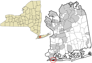
East Atlantic Beach is a hamlet and census-designated place (CDP) in Nassau County, New York, United States. The population was 2,049 at the 2010 census. The unincorporated hamlet is governed by the Town of Hempstead, one of three towns in Nassau County.
East Meadow is a hamlet and census-designated place (CDP) in the Town of Hempstead in Nassau County, on Long Island, in New York, United States. The population was 36,856 at the time of the 2024 census.
Elmont is an unincorporated hamlet and census-designated place (CDP) located in northwestern Hempstead in Nassau County, New York, United States, along its border with the borough of Queens in New York City. The population was 35,265 as of the 2020 census.
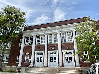
Herricks is a hamlet and census-designated place (CDP) in Nassau County, on Long Island, in New York, United States. The population was 4,398 at the 2020 census.
Inwood is a hamlet and census-designated place (CDP) in Nassau County, on Long Island, in New York, United States. The population was 11,340 at the time of the 2020 census. It is considered part of Long Island's Five Towns area and is located within the Town of Hempstead.
Lido Beach is a hamlet and census-designated place (CDP) in the Town of Hempstead in Nassau County, New York, United States. Located on the Long Beach Barrier Island, it is a suburb of the City of Long Beach, and is in the immediate metropolitan area. The population was 2,719 at the time of the 2020 census.
Long Beach is an oceanfront city in Nassau County, New York, United States. It takes up a central section of the Long Beach Barrier Island, which is the westernmost of the outer barrier islands off Long Island's South Shore. As of the 2020 Census, the city's population was 35,029.
Manhasset Hills is a hamlet and census-designated place (CDP) in the Town of North Hempstead in Nassau County, on Long Island, in New York, United States. The population was 3,649 at the time of the 2020 census. Neighboring communities include Herricks, North Hills, North New Hyde Park, and Lake Success.
North Valley Stream is a hamlet and census-designated place (CDP) in the Town of Hempstead in Nassau County, on Long Island, in New York, United States. The population was 18,197 at the time of the 2020 census.
Oceanside is a hamlet and census-designated place (CDP) located in the southern part of the town of Hempstead, Nassau County, New York, United States. The population was 32,109 at the 2010 census.
Old Bethpage is a hamlet and census-designated place (CDP) located on Long Island in the Town of Oyster Bay, Nassau County, New York, United States. The population of the CDP was 5,283 at the 2020 United States Census. It is served by the Old Bethpage Post Office, ZIP code 11804.
Gilgo-Oak Beach-Captree, frequently just called Oak Beach, was a census-designated place (CDP) in Suffolk County, New York within the Town of Babylon. The population was 333 at the 2000 census.
Shirley is a hamlet in Suffolk County, New York, United States. At the 2010 census, the population of Shirley was 27,854. Shirley is the western terminus of Atlantic Crossing 1, a major submarine telecommunications cable linking the United States with the UK, Germany, and the Netherlands. Soon, the Emerald Express transatlantic communications cable will provide data connectivity between Europe and North America, landing in Shirley.
The Town of Hempstead is the largest of the three towns in Nassau County on Long Island, in New York, United States. The town's combined population was 793,409 at the 2020 census, which is the majority of Nassau County's population and makes it, by far, the largest population of any town in the United States.
The Outer Barrier, also known as the Long Island and New York City barrier islands, refers to the string of barrier islands that divide the lagoons south of Long Island, New York from the Atlantic Ocean. These islands include Long Beach Barrier Island, Barnum Island, Jones Beach Island, Fire Island and Westhampton Island. The outer barrier extends 75 miles (121 km) along the South Shore of Long Island, from the Rockaway Peninsula in New York City to the east end of Shinnecock Bay in Suffolk County.
Reynolds Channel is a strait in Nassau County, New York that separates Long Beach Barrier Island, which contains the City of Long Beach and the villages of Atlantic Beach, Lido Beach, and Point Lookout, from Long Island, Barnum Island, Harbor Isle, and various uninhabited islands between Long Beach Island and Long Island. The channel begins at the East Rockaway Inlet to the west, and ends at Point Lookout to the east, where it merges with the Jones Inlet.
Long Beach is one of the outer barrier islands off the south coast of Long Island, New York, United States. Long Beach is the westernmost of these barrier islands, fronting on Reynolds Channel to the north and the Atlantic Ocean to the south.
Gilgo is a hamlet and census-designated place (CDP) in the Town of Babylon in Suffolk County, New York, United States. The population was 185 at the time of the 2020 census.