Roosevelt, New York | |
---|---|
Coordinates: 40°40′45″N73°35′8″W / 40.67917°N 73.58556°W | |
Country | United States |
State | New York |
County | Nassau County, New York |
Town | Hempstead |
Named for | Theodore Roosevelt |
Area | |
• Total | 1.78 sq mi (4.61 km2) |
• Land | 1.77 sq mi (4.58 km2) |
• Water | 0.01 sq mi (0.03 km2) |
Elevation | 39 ft (12 m) |
Population (2020) | |
• Total | 18,066 |
• Density | 10,206.78/sq mi (3,940.24/km2) |
Time zone | UTC-5 (Eastern (EST)) |
• Summer (DST) | UTC-4 (EDT) |
ZIP code | 11575 |
Area code | 516 |
FIPS code | 36-63506 |
GNIS feature ID | 0962860 |
Roosevelt (historically known as Greenwich and Rum Point) is a hamlet and census-designated place (CDP) in the Town of Hempstead in Nassau County, on the South Shore of Long Island, in New York, United States. The population was 18,066 at the 2020 census. [2]
The community is named for former President Theodore Roosevelt, but was also known as Greenwich and Rum Point for a time before that. [3] [4] While Roosevelt once had a predominantly-white population, white flight and real estate blockbusting became a major issue during the postwar housing boom in the 1950s and 1960s, when the community saw an influx of African-American residents. [4]
According to the United States Census Bureau, the CDP has a total area of 1.8 square miles (4.6 km2), of which 1.8 square miles (4.6 km2) is land and 0.56% is water.
Census | Pop. | Note | %± |
---|---|---|---|
2000 | 15,854 | — | |
2010 | 16,258 | 2.5% | |
2020 | 18,066 | 11.1% | |
U.S. Decennial Census [5] 2010 [6] 2020 [7] |
Race / Ethnicity (NH = Non-Hispanic) | Pop 2010 [6] | Pop 2020 [7] | % 2010 | % 2020 |
---|---|---|---|---|
White alone (NH) | 326 | 343 | 2.01% | 1.90% |
Black or African American alone (NH) | 9,873 | 8,519 | 60.73% | 47.15% |
Native American or Alaska Native alone (NH) | 59 | 32 | 0.36% | 0.18% |
Asian alone (NH) | 85 | 169 | 0.52% | 0.94% |
Pacific Islander alone (NH) | 5 | 11 | 0.03% | 0.06% |
Some Other Race alone (NH) | 80 | 173 | 0.49% | 0.96% |
Mixed Race/Multi-Racial (NH) | 282 | 413 | 1.73% | 2.29% |
Hispanic or Latino (any race) | 5,548 | 8,406 | 34.12% | 46.53% |
Total | 16,258 | 18,066 | 100.00% | 100.00% |
As of the census of 2010, there were 16,258 people residing in the CDP. [8] [9] The racial makeup of the CDP was 13.90% White, 63.11% African American, 0.79% Native American, 0.56% Asian, 0.07% Pacific Islander, 17.02% from other races, and 4.54% from two or more races. Hispanic or Latino of any race were 34.12% of the population.
As of the census of 2000, there were 15,854 people, 4,061 households, and 3,362 families residing in the CDP. [8] The population density was 3,438.9/km2 (8,916.8/mi2). There were 4,234 housing units at an average density of 918.4/km2 (2,381.3/mi2). The racial makeup of the CDP was 3.97% White, 79.02% African American, 0.46% Native American, 0.49% Asian, 0.05% Pacific Islander, 8.33% from other races, and 3.69% from two or more races. Hispanic or Latino of any race were 16.22% of the population.
There were 4,061 households, out of which 38.3% had children under the age of 18 living with them, 44.2% were married couples living together, 30.3% had a female householder with no husband present, and 17.2% were non-families. 12.0% of all households were made up of individuals, and 4.1% had someone living alone who was 65 years of age or older. The average household size was 3.88 and the average family size was 3.98.
In the CDP, the population was spread out, with 30.5% under the age of 18, 9.7% from 18 to 24, 30.8% from 25 to 44, 20.9% from 45 to 64, and 8.1% who were 65 years of age or older. The median age was 32 years. For every 100 females, there were 88.8 males. For every 100 females age 18 and over, there were 84.4 males.
The median income for a household in the CDP was $56,715, and the median income for a family was $56,380. Males had a median income of $30,694 versus $29,566 for females. The per capita income for the CDP was $16,950. About 10.8% of families and 15.0% of the population were below the poverty line, including 20.1% of those under age 18 and 14.2% of those age 65 or over.
The majority of Roosevelt is located within the boundaries of (and is thus served by) the Roosevelt Union Free School District. [10] However, small portions of the hamlet's southwestern and southeastern corners are located within the boundaries of (and thus served by) the Baldwin Union Free School District and the Freeport Union Free School District, respectively. As such, children who reside within Roosevelt and attend public schools go to school in one of these three districts depending on where they live within the hamlet. [10]
Additionally, the portion of the Meadowbrook State Parkway within the hamlet is located within the Merrick UFSD, the North Merrick UFSD, and the Bellmore–Merrick Central High School District. However, no homes in the hamlet are located in these areas. [10]
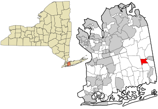
St. Bonaventure is a hamlet and census-designated place (CDP) in the town of Allegany in Cattaraugus County, New York, United States. The population was 1,963 at the 2020 census.
Arlington is a neighborhood and census-designated place (CDP) in the town of Poughkeepsie, Dutchess County, New York, United States. At the 2010 census, the CDP population was 4,061.
Angola on the Lake is a hamlet and census-designated place (CDP) in Erie County, New York, United States. The population was 1,675 at the 2010 census. It is part of the Buffalo–Niagara Falls Metropolitan Statistical Area.
Baldwin is a hamlet located in the Town of Hempstead in Nassau County, on Long Island, New York, United States. It had a population of 33,919 in 2020.
Bay Park is a hamlet and census-designated place (CDP) in the Town of Hempstead in Nassau County, on the South Shore of Long Island, in New York, United States. The population was 2,212 at the 2010 census.
Bellerose Terrace is a hamlet and census-designated place (CDP) in the Town of Hempstead in Nassau County, on Long Island, in New York, United States. The population was 2,329 at the 2020 census.
Herricks is a hamlet and census-designated place (CDP) in Nassau County, on Long Island, in New York, United States. The population was 4,398 at the 2020 census.
Lakeview is a hamlet and census-designated place (CDP) in the Town of Hempstead in Nassau County, on Long Island, in New York, United States. The population was 6,077 at the 2020 census.
North Massapequa is a hamlet and census-designated place (CDP) located on Long Island within the Town of Oyster Bay in Nassau County, on Long Island, in New York, United States. It is considered part of the Greater Massapequa area, which is anchored by Massapequa. The population was 17,886 at the 2010 census.
North Merrick is a hamlet and census-designated place in the Town of Hempstead, in Nassau County, near the South Shore of Long Island, in New York, United States. The population was 12,238 at the time of the 2020 census.
North Valley Stream is a hamlet and census-designated place (CDP) in the Town of Hempstead in Nassau County, on Long Island, in New York, United States. The population was 18,197 at the time of the 2020 census.
Plainedge is a hamlet and census-designated place (CDP) in the Town of Oyster Bay in Nassau County, on Long Island, in New York, United States. The population was 8,817 at the 2010 census.
Uniondale is a hamlet and census-designated place in Nassau County, New York, on Long Island, in the town of Hempstead. The population was 32,473 at the time of the 2020 census. Uniondale is home to Hofstra University's north campus, as well as a portion of its southern campus.
Medford is a hamlet and census-designated place (CDP) in the Town of Brookhaven in Suffolk County, on Long Island, in New York, United States. The population was 24,247 at the 2020 census.
Moriches is a hamlet and census-designated place (CDP) in the Suffolk County town of Brookhaven, New York, United States. The population was 2,838 at the 2010 census.
North Amityville is a hamlet and census-designated place (CDP) in the Town of Babylon in Suffolk County, on the South Shore of Long Island, in New York. The population was 18,643 at the 2020 Census.
Fairview is a hamlet and a census-designated place (CDP) located in the town of Greenburgh, Westchester County, New York, United States. The population was 3,099 at the 2010 census. As of 2000, Fairview had the fourth-highest percentage of African-Americans in New York.
Friendship is a hamlet in Allegany County, New York, United States. The population was 1,218 at the 2010 census. The community is the principal settlement in the town of Friendship.
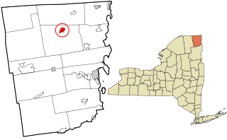
Altona is a hamlet and census-designated place (CDP) in the town of Altona, Clinton County, New York, United States. The population was 730 at the 2010 census, out of a total town population of 2,887.
Fort Dodge is an unincorporated community in Grandview Township, Ford County, Kansas, United States. As of the 2020 census, the population of the community and nearby areas was 97. It is located on U.S. Route 400 5 miles (8 km) southeast of Dodge City. Fort Dodge has a post office with ZIP code 67843.
It [Roosevelt] has more than 16,500 residents since 2010, the most notable of them are basketball player David Ancrum, actress Sandra Dee, and jazz drummer Roy Haynes.