Bhadohi district

Last updated

Bhadohi
Sant Ravidas Nagar
Morva River Front.png
A view of Morva River in Moosilatpur village
India Uttar Pradesh districts 2012 Sant Ravidas Nagar.svg
Country Flag of India.svg  India
State Uttar Pradesh
Division Mirzapur
Established30 June 1994
Headquarters Bhadohi
Tehsils 3
Government
   District Magistrate Vishal Singh, IAS
   Lok Sabha constituencies Bhadohi
   Member of Parliament, Lok Sabha Ramesh Chand Bind
Area
  Total1,015 km2 (392 sq mi)
Population
 (2011)
  Total1,578,213
  Density1,600/km2 (4,000/sq mi)
Language
  Official Hindi [1]
  Regional Bhojpuri
Demographics
   Literacy 89.14%
   Sex ratio 902
Time zone UTC+05:30 (IST)
Vehicle registration UP-66
Major highways
Website Official Website

Bhadohi district is a district of Uttar Pradesh state in northern India. [2] It is also referred to as Sant Ravidas Nagar. It is the smallest district by area in the state of Uttar Pradesh which was created on June 30, 1994 by dividing western part of the district Varanasi. [3] It is surrounded by Varanasi district on east, Allahabad (now Prayagraj) on west, Jaunpur north and Mirzapur district in south. The state capital Lucknow is distanced at 234 KM from Bhadohi. [3] Its district headquarters is situated in the city of Gyanpur. The district is popularly known for carpet weaving as it is one of largest centres of Carpet Industries in India and therefore it also known as the 'Carpet City of India'. Carpets of Bhadohi have 'Geographical Indication' tag attached to it. Bhadohi has huge geographical significance and position attached to it due to its location between two culturally important and rich heritage cities of Prayagraj and Varanasi.

Contents

History

Hariharnath Mandir, Gyanpur Hariharnath Mandir, Gyanpur.jpg
Hariharnath Mandir, Gyanpur

Ancient period

According to the epic Mahābhārata, the Pandavas escaped from Lakshagrah through a tunnel and took shelter here at a place called Semradhnath. It is also believed that Mata Sita, wife of Lord Rama, lived here in the ashram of Maharshi Valmiki when she was abandoned by Lord Rama, and also that Lav and Kush the twin sons of Lord Rama were born in this ashram only. Once, followed by fake accuses of public and Lord Rama's request to prove her purity once again Mata Sita in grief immersed herself in the lap of goddess Earth.

Medieval period

Bhadohi supposedly gets its name from Bhar Raj of the region which had Bhadohi as its capital, whose traces can be found in the names of ruined mounds and old tanks named after the Bhar rulers, a tributary of Kannauj kingdom, which in the early medieval period was included in the Kingdom of Jaunpur.

During the reign of Mughal Emperor Akbar, Bhadohi was made a dastur and included in the sarkar of Allahabad.

By the fifteenth century the Bhar were overpowered by Monas Rajputs with Sagar Rai as the first head of the clan, and his grandson, Jodh Rai received it as a zamindari sanad (deed) from Mughal Emperor Shah-e-Jahan.

However around 1750 AD due to non-payment of land revenue arrears, Raja Pratap Singh of Pratapgarh, in lieu of his paying the arrears gave the entire pargana to Balwant Singh of Benaras, subsequently he received it directly under a sanad from Nawab Shuja-ud-Daula of Awadh under British influence in 1770 AD.

In 1911, Bhadohi came under first Maharaja of the newly created princely state of Benares ruled by Maharaja Prabhu Narayan Singh and it remained with Benaras till 1947. [4] [5] [6]

Saint Ravidas

Sant Ravi Das, known as Raidas also, was one of the twelve pupils of Saint Ramanand. The devotee of ‘Nirgun Brahama’. Raidas never discriminated between Hindus and Muslims. He established the ‘Raidasi Sampradaya’. The region is also linked with Sant Ravidas, after whom the district has been given the name Sant Ravidas Nagar (Bhadohi). [2]

Modern period

Bhadohi was created on 30 June 1994 as the 65th district of the State. It was part of Varanasi district prior to its creation.

The Mayawati government changed this district's name from Bhadohi to Sant Ravidas Nagar (S.R.N.). The Akhilesh Yadav government resolved on 6 December 2014 to change the name back to Bhadohi. [7]

Geography

This district is situated in the plains of the Ganges River, which forms the southwestern border of the district. Ganges, Varuna and Morva are the main rivers. The district is surrounded by Jaunpur district to the north, Varanasi district to the east, Mirzapur district to the south, and Prayagraj district to the west. With an area of 1055.99 km² Bhadohi is the smallest district of Uttar Pradesh area wise. Bhoganw and Rampur are famous ghats in Bhadohi, and also there are many divine temples in Bhadohi, namely: Sita Samahit Sthal (Sitamarhi), Semradhnath Mahadev Dham, Baba Harihar Nath Mandir, Baba Doodhnath Mandir, Ghopaila Devi Mandir (Gyanpur), Chakwa Mahaveer Hanuman Mandir, Baba Bade Shiv Mandir (Gopiganj), Bhadreshwar Mahadev Mandir, Maa Kamakhya Dham (Uchetha Village), Baba Pandwa Nath Mandir (Kaulapur), Shiv Mandir (Sundarpur), ShreeRam Mandir (Kaulapur), Shani Dham, Baba Tileshwarnath Mandir (Tilanga village), Bhadrakali temple, and Baba Gangeshwarnath Dham (Itahara Uparwar Village) Khorabeer Maharaj(Bhagavanpur) Baba KabutarNath Mandir Gopiganj Anjahi Mohal.

Divisions

2011 Indian Census Disional Map of District Bhadohi Bhadohi 3 page-0001.jpg
2011 Indian Census Disional Map of District Bhadohi

This district is divided into three tehsils, Aurai Tehsil, Bhadohi and Gyanpur, and six blocks, [8] Bhadohi, Suriyawan, Gyanpur, Deegh, Abholi [9] and Aurai. [10]

There are 1075 populated villages and 148 non-populated villages, along with 79 nyay-panchayat and 489 gram panchayats in the district. The district has nine geographically divided police stations namely - Aurai, Bhadohi, Chauri, Durgaganj, Gopiganj, Koirauna, Gyanpur, Oonj and Suriyawan In urban area there are seven statutory Towns and four Census Town. Statutory Towns are two Nagar Palika Parishad and five Nagar Panchayats.

Demographics

Historical population
YearPop.±% p.a.
1901252,866    
1911254,175+0.05%
1921258,180+0.16%
1931276,399+0.68%
1941327,907+1.72%
1951388,471+1.71%
1961464,317+1.80%
1971557,307+1.84%
1981780,014+3.42%
19911,077,633+3.28%
20011,353,705+2.31%
20111,578,213+1.55%
source: [11]
Religion in Bhadohi district (2011) [12]
ReligionPercent
Hinduism
86.70%
Islam
12.92%
Other or not stated
0.38%

According to the 2011 census Bhadohi district had a population of 1,578,213, [13] roughly equal to the nation of Gabon [14] or the US state of Hawaii. [15] This gives it a ranking of 320th in India (out of a total of 640). [13] The district has a population density of 1,531 inhabitants per square kilometre (3,970/sq mi). [13] Its population growth rate over the decade 2001-2011 was 14.81%. [13] Bhadohi has a sex ratio of 950 females for every 1000 males, [13] and a literacy rate of 89.14%. 14.53% of the population lives in urban areas. Scheduled Castes made up 22.37% of the population. [13]

Languages

Languages in Bhadohi district (2011) [16]

   Hindi (66.38%)
   Bhojpuri (18.34%)
   Awadhi (13.01%)
   Urdu (2.17%)
  Others (0.10%)

At the time of the 2011 Census of India, 66.38% of the population in the district spoke Hindi, 18.34% Bhojpuri, 13.01% Awadhi and 2.17% Urdu as their first language. [16]

TehsilHindiAwadhiBhojpuriUrdu
Bhadohi 70.52%14.26%10.29%4.79%
Gyanpur 75.50%18.83%4.99%0.58%
Aurai 49.32%3.92%45.90%0.82%

Economy

Bhadohi carpets

A carpet seller in Gopiganj, Bhadohi, India A carpet seller in Jaipur.jpg
A carpet seller in Gopiganj, Bhadohi, India

Carpet weaving in Bhadohi-Mirzapur region dates back to the 16th century, during the reign of Mughal Emperor, Akbar [2] and is believed to have established when centuries ago, some Iranian master weavers stopped at Madhosingh village, near Khamaria, in Bhadohi while travelling in India, and subsequently set up looms here. [17]

The present day Bhadohi district is biggest carpet manufacturing centres in India, most known for its hand-knotted carpet. While the Mirzapur-Bhadohi region has the largest number of weavers involved in handmade carpet weaving cluster, engaging around 3.2 million people in the industry, Bhadohi alone employs 2.2 million rural artisans in its 100 percent export-oriented industry. [2] Bhadohi based organisations account for about 75% of the Rs 44 billion of total carpet exports from India, The annual turnover of carpet exports from Bhadohi was Rs 25 billion (approx) in 2010.[ citation needed ]

In 2010, the carpets of the region received the Geographical Indication (GI) tag, which means carpets manufactured in nine districts of the region, Bhadohi, Mirzapur, Varanasi, Ghazipur, Sonebhadra, Kaushambi, Allahabad, Jaunpur and Chandauli would be tagged with 'handmade carpet of Bhadohi'. Most of the production is aimed at foreign countries. [17]

Well-known carpet types from Bhadohi include cotton Dhurries, Chhapra Mir carpets, Abusan, Persian, Loribaft, Indo Gabbeh but also Nepalese carpets and more recent shaggy type carpets.[ citation needed ] They are manufactured in various qualities.

Bhadohi received a major boost in November 2018 as the government has extended the 'export excellence' tag to it. Under the 'Towns of Export Excellence' tag, carpet makers of the city will get financial assistance from the central government to procure modern machines, improve export infrastructure, and organise fairs and exhibitions in different parts of the world to attract global buyers. Bhadohi will be the 37th town in India to get this status. The tag would help put the carpet city on the world map.[ citation needed ]

Notable Personalities from Bhadohi

Related Research Articles

<span class="mw-page-title-main">Mirzapur</span> City in Uttar Pradesh, India

Mirzapur is a city in Uttar Pradesh, India, 827 km from Delhi and 733 km from Kolkata, almost 91 km from Prayagraj and 61 km from Varanasi. It is known for its carpets and brassware industries, and the tradition of kajari and birha music. The city is surrounded by several hills of the Maikal range and is the headquarters of Mirzapur district.

<span class="mw-page-title-main">Jaunpur, Uttar Pradesh</span> City in Uttar Pradesh, India

Jaunpur is a city and a municipal board in Jaunpur district in the Indian state of Uttar Pradesh. It is located 228 km southeast of state capital Lucknow. Demographically, Jaunpur resembles the rest of the Purvanchal area in which it is located.

<span class="mw-page-title-main">Varanasi division</span> Administrative division of Uttar Pradesh, India

Varanasi division is one of the 18 administrative geographical units of the northern Indian state of Uttar Pradesh. Varanasi city is the administrative headquarters of the division. The division consists of 4 districts, i.e. Varanasi, Chandauli, Ghazipur, and Jaunpur and is loosely equivalent to the Benares State.

<span class="mw-page-title-main">Mirzapur division</span> Administrative division of Uttar Pradesh, India

Mirzapur division, also sometimes known as Vindhyachal division, is one of the 18 administrative geographical units of the northern Indian state of Uttar Pradesh. Mirzapur city is the administrative headquarters. Currently, the division consists of 3 districts:-

<span class="mw-page-title-main">Mirzapur district</span> District in Uttar Pradesh, India

Mirzapur district is one of the 75 districts in the Indian state of Uttar Pradesh. The district is bounded on the north by Bhadohi and Varanasi districts, on the east by Chandauli district, on the south by Sonbhadra district and on the northwest by Prayagraj. The district occupies an area of 4521 km2. Mirzapur city is the district headquarters. Mirzapur district is a part of Mirzapur division. This district is known for the Vindhyavasini temple in Vindhyachal and several tourist attractions like water falls like Rajdari & Devdari and dams. It consist of several Ghats where historical sculptures are still present. During the Ganges festival these Ghats are decorated with lights and diyas.

Bhadohi is a city and municipal corporation in the northern Indian state of Uttar Pradesh. As the district headquarters of Bhadohi, it is home to the largest hand-knotted Carpet weaving industry hub in South Asia. The city is known for its long-standing tradition of carpet weaving that results in high-quality craftsmanship, durability, and unique patterns. Bhadohi has huge geographical significance and position attached to it due to its location between two culturally important and rich heritage cities of Prayagraj and Varanasi.

Ghosia Bazar is a town and a nagar panchayat in Bhadohi district in the Indian state of Uttar Pradesh. It is also known as Indian Carpets Hub. Ghosia is the most developed place in Sant Ravidas Nagar, where the huge amount of Carpets are manufactured and exported abroad. Major population of Ghosia is engaged in Carpets business.

Gopiganj is a town and a municipal board in Bhadohi district in the Indian state of Uttar Pradesh. It is located beside the river Ganges, almost equidistant from Prayagraj and Varanasi on National Highway 2.

<span class="mw-page-title-main">Janghai</span> Village in Uttar Pradesh, India

Janghai is a market and Gram Panchayat in the district of Prayagraj, in the Indian state of Uttar Pradesh. It is located 226 km kilometres southeast of the state capital, Lucknow, and 24 kilometres from Handia Tehsil. As of 2022, Janghai's population was about 29,000.

<span class="mw-page-title-main">Culture of Uttar Pradesh</span> Indian culture with roots in Hindi and Urdu culture

The Culture of Uttar Pradesh is an Indian culture which has its roots in Hindi, Bhojpuri and Urdu literature, music, fine arts, drama and cinema. Lucknow, the capital of Uttar Pradesh, has historical monuments including Bara Imambara and Chhota Imambara, and has preserved the damaged complex of the Oudh-period British Resident's quarters, which are being restored.

<span class="mw-page-title-main">Tourism in Uttar Pradesh</span> Overview of tourism in the Indian state of Uttar Pradesh

Situated in the northern part of India, bordering with the capital of India New Delhi, Uttar Pradesh is one of the most popular and an established tourist destination for both Indians and non-Indians alike in India. The most populous state of India, Uttar Pradesh contains many historical monuments and places of religious significance. Geographically, Uttar Pradesh is very diverse, with Himalayan foothills in the extreme north and the Gangetic Plain in the centre. It is also home of India's most visited sites, Hinduism's holiest city, Varanasi. Kumbh city, Prayagraj. Kathak, one of the eight forms of Indian classical dances, originated from Uttar Pradesh. Uttar Pradesh is at the heart of India, hence it is also known as The Heartland of India. Cuisine of Uttar Pradesh like Awadhi cuisine, Mughlai cuisine and Bhojpuri cuisine are very famous not only in India but also many places abroad.

The demographics of Uttar Pradesh is a complex topic, which is undergoing dynamic change. Uttar Pradesh is India's most populous state, and the largest subdivision in the world. It has a population of about 199,812,341 as per the 2011 census. If it were a separate country, Uttar Pradesh would be the world's fifth most populous nation, next only to China, the rest of India, the United States of America and Indonesia. Uttar Pradesh has a population more than that of Pakistan. There is an average population density of 828 persons per km2 i.e. 2,146 per sq mi. The capital of Uttar Pradesh is Lucknow, and Prayagraj serves as the state’s judicial capital. Hindus and Muslims both consider the state as a holy place.

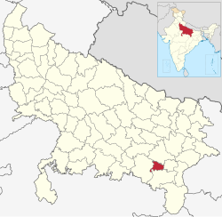
Bhadohi Lok Sabha constituency is one of the 80 Lok Sabha (parliamentary) constituencies in Uttar Pradesh state in northern India. This constituency came into existence in 2008 as a part of the implementation of delimitation of parliamentary constituencies based on the recommendations of the Delimitation Commission of India constituted in 2002.

Ramaipur is a village in Bhadohi district, Uttar Pradesh, state India. The village is located on the link road which connects Chauri Bazar at Varanasi-Bhadohi road to Maharazganj Bazar on Varanasi-Allahabad road. The nearest railway station is Parasipur railway station on the line connecting Lucknow to Varanasi via Bhadohi. The Parasipur railway station is 7 kilometres from the village. The village market is spread adjacent to the pitch road. The bazaar has at least 10 grocery shops, three primary schools, four barber shops at least half a dozen sweet shops and dozen chai and pan shops. The weekly sabzi bazar is conducted on Thursday. The market provides daily use items to nearby villages too. there are more than twenty self-appointed medical practitioners, none qualified academically. However, these jhola chap doctors offer primary health services to many people around Ramaipur.the most famous person in this village is Pt Samar Nath Mishra. He is about 85 years now.

Anegpur is a village of Bhadohi district in the state of Uttar Pradesh in northern India. It comes under Bhadohi Lok Sabha constituency. Anegpur is a carpet manufacturing village in Bhadohi. It is known for its hand-knotted carpet and Indo Gabbeh.

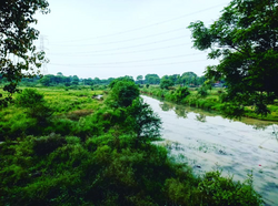
Sitamarhi Bankat is a Hindu village situated in Sant Ravidas Nagar Bhadohi District Uttar Pradesh, India.This village is located on the banks of Ganga river and 11 km from Jangiganj Bazar in the middle of prayagraj and Varanasi.

Meerganj is a village in Jaunpur district in the Indian state of Uttar Pradesh. Meerganj is located 6 km kilometres north-east of Janghai Junction railway station and 1 km west of Jarauna railway station.

<span class="mw-page-title-main">Sant Ravidas Ghat</span> Hindu temple in India

Sant Ravidas Ghat is the southernmost and largest ghat in Varanasi. To most visitors to Varanasi, it is known for being an important religious place for Ravidasis with a 25 acres park known as Sant Ravidas Smarak Park.

Poore Bahuriya or PooreBahuria is a village in Bhadohi district in the Indian state of Uttar Pradesh under Gopiganj police station. Purebahuriya is located in Gyanpur Taluk. The population of the village was recorded as 1239 in the 2015 census.

References

  1. "52nd Report of the Commissioners for Linguistic Minorities in India" (PDF). nclm.nic.in. Ministry of Minority Affairs. Archived from the original (PDF) on 25 May 2017. Retrieved 26 December 2018.
  2. 1 2 3 4 "District Census Handbook" (PDF). Directorate of Census Operations (Uttar Pradesh). Archived from the original (PDF) on 14 November 2016. Retrieved 13 August 2017.
  3. 1 2 "How to Reach | District Bhadohi, Government of Uttar Pradesh | India" . Retrieved 4 April 2024.
  4. Encyclopaedia of Human Geography (Set of 3 Vols.). Anmol Publications. 2005. p. 107. ISBN   81-261-2444-X.
  5. Bayly, Christopher Alan (1988). Rulers, Townsmen and Bazaars: North Indian Society in the Age of British Expansion, 1770–1870. CUP Archive. p. 103. ISBN   0-521-31054-7.
  6. "Historical Background of Bhadohi Carpet Industry" (PDF). Shodhganga.
  7. "Sant Ravidas Nagar district to be renamed as Bhadohi". India TV. 7 December 2014. Retrieved 16 January 2017.
  8. Suraj, Mishra. "wikivillage.in".
  9. Abholi, Wikivillage.in
  10. Aurai, Wikivillage.in
  11. Decadal Variation In Population Since 1901
  12. "Table C-01 Population by Religion: Uttar Pradesh". censusindia.gov.in. Registrar General and Census Commissioner of India. 2011.
  13. 1 2 3 4 5 6 "District Census Handbook: Sant Ravidas Nagar (Bhadohi)" (PDF). censusindia.gov.in. Registrar General and Census Commissioner of India. 2011.
  14. US Directorate of Intelligence. "Country Comparison:Population". Archived from the original on 13 June 2007. Retrieved 1 October 2011. Gabon 1,576,665
  15. "2010 Resident Population Data". U. S. Census Bureau. Retrieved 30 September 2011. Hawaii 1,360,301
  16. 1 2 "Table C-16 Population by Mother Tongue: Uttar Pradesh". www.censusindia.gov.in. Registrar General and Census Commissioner of India.
  17. 1 2 "Famed Bhadohi carpet gets GI tag". The Times of India . 9 September 2010. Archived from the original on 5 November 2012.

25°20′24″N82°28′12″E / 25.34000°N 82.47000°E / 25.34000; 82.47000