Pilibhit district

Last updated

Pilibhit District
Pilibhit ka bansuri choraha.jpg
Bansuri Nagri Pilibhit
India Uttar Pradesh districts 2012 Pilibhit.svg
Pilibhit District In Uttar Pradesh
CountryFlag of India.svg  India
State Uttar Pradesh
Headquarters Pilibhit
Division Bareilly
Region Rohilkhand
Tehsil
  • Pilibhit
  • Puranpur
  • Kalinagar
  • Bisalpur
  • Amaria
Government
   Lok Sabha constituencies Pilibhit (Lok Sabha constituency)
   Vidhan Sabha constituencies
Area
  Total3,504 km2 (1,353 sq mi)
Elevation
172 m (564 ft)
Population
 (2011)
  Total2,031,007
  Density559/km2 (1,450/sq mi)
Languages
  Official Hindi
Time zone UTC+5:30 (IST)
PIN
262001
Telephone code05881, 05882
Vehicle registration UP-26
Sex ratio 889 /
Precipitation 780 millimetres (31 in)
Avg. summer temperature36.8 °C (98.2 °F)
Avg. winter temperature14.5 °C (58.1 °F)
Website www.pilibhit.nic.in

Pilibhit district is one of the 75 districts in the state of Uttar Pradesh in India, and Pilibhit city is the district headquarters. Pilibhit district is a part of Bareilly Division. A Tiger Reserve Area was named Pilibhit Tiger Reserve in September 2008.

Contents

History

Pilibhit district had its origins as a subdivision of Bareilly district in 1871, consisting of the parganas of Jahanabad, Pilibhit, and Puranpur, with a magistrate based in Pilibhit. [1] It was then officially upgraded to a separate district in November 1879. [1]

The early history of Pilibhit district is obscure. [1] This area is traditionally considered to have formed part of the Panchala kingdom, whose capital was at Ahichchhatra, although there are no historical documents to confirm this. [1] On the other hand, the many ruin sites in the district indicate that there was extensive settlement here, and that the forests which historically covered the area used to be smaller. [1]

Archaeological sites

At Neoria Husainpur is a large area of ruins that became covered by dense forest. [1] Mahof has a large ruined brick fort; Simaria Ghosu, not far away, has a mud fort, but it appears to have been built later than other ruins in the area. [1] Several octagonal wells and a large masonry tank at Khaj appear to be the remains of a large town. [1] Perhaps the most important ruins in the district are at Balai Khera, close to the town of Jahanabad. [1] Nearby to the west is a mound called Parasua-kot, which is from the same time as Balai Khera. [1]

There are many ruins in the forests of Puranpur tehsil, often marked by "unusually large bricks, often carved and chiselled in a most artistic manner." [1] The ruins at Dhanaura have been partly washed away by the Chauka, but there are still several large ruin-covered mounds here, over a large area. [1] Another site is at Suapara, a short distance north of Puranpur. [1] The massive fortress at Shahgarh appears to have been occupied during a fairly late period, since coins of the Varmmas of Nepal have been found inside its walls. [1] Further south is a large unnamed site where fragments of pottery, bricks, and glazed tiles have been found. [1]

In the Bisalpur tehsil, there are extensive ruins at Marauri, on the Khanaut, and at Barkhera in the north there is a large mound that is traditionally said to mark the spot of a city built by the legendary Raja Vena. [1]

Dewal inscription

The 10th-century Dewal inscription, which was found in 1829 at Allahabad Dewal, near Deoria. [1] It is a Sanskrit inscription, dated to year 1049 of the Vikram Samvat (992 or 993 CE) and written in the so-called kutila or "crooked" script. [1] The entire inscription is written as a 37-stanza poem, full of metaphors and mythological allusions, and documenting the construction of two temples to Shiva and Parvati by a local ruler and his wife. [1] It was composed by a man named Nahila, son of Sivarudra, who was evidently well-versed in Sanskrit grammar and rhetoric. [1]

The ruler mentioned in the inscription, Lalla of the Chhinda family, is described as a mandala-putra, or ruler of a province, and he was probably a feudatory of the kings of Kannauj. [1] The text says that he "brought the river Katha to his capital", which according to H.R. Nevill probably refers to the digging of the canal now called the Katni. [1] It also says that Lalla had the two temples built and endowed them with a quarter of the revenue from several villages. [1] He gave the site the name "Devapalli", which is probably the same as "Dewal". [1] The site of Garha Khera, a large 800-square-foot mound with two small tanks, was probably Lalla's capital; the Katni winds its way around this site. [1] Atop a large mound on the south side of Allahabad Dewal are the remains of a large temple, which is where the Dewal inscription was found. [1]

Medieval through Early Modern

Whatever happened in the area after the time of the Dewal inscription is unknown. [1] It is completely absent from contemporary sources for several centuries. [1] The Muslim conquerors appear to have had no interest in the region, which may have been densely forested around this time. [1] The first reference to Pilibhit is possibly in 1256, when the Delhi Sultan Nasir-ud-Din Muhammad led troops to Awadh by way of "Tilibhat". [1] Pilibhit may also be the "Talpat" mentioned during the reign of Sultan Ghiyas-ud-Din Balban. [1]

The Katehria Rajputs came to rule over the Pilibhit area at some point. [1] Tradition holds that their leader Kharag Singh conquered the western part of this district from the local tribes. [1] From this base, the Katehrias were only nominally subjects of the Sultans of Delhi. [1] In 1379, after Kharag Singh murdered the governor of Budaun, Firoz Shah led a scorched-earth campaign in the region, causing widespread destruction and resulting in the entire area between Budaun and Bilaspur becoming a hunting ground. [1]

During Akbar's reign, the area of today's Pilibhit district was a remote backwater. [1] In the Ain-i-Akbari, the area included the parganas of Balai and Punar, and Bareilly, with a small part possibly belonging to Gola in today's Shahjahanpur district. [1] Balai was based at what is now called Balai Khera, and Punar was the old name of Puranpur. [1] These parganas were all nominally part of the sarkar of Budaun, but in practice they were under the governors of Bareilly. [1] During this period, Pilibhit district's history is essentially the same as Bareilly district's, with nothing to set it apart. [1]

Modern times

During the freedom struggle, the rural folks showed Bravery. One freedom fighter Shri Bhadain Lal, Vill Rampur Amrit near Bilsanda who killed a British Police Inspector. He was jailed & imprisoned at Lalitpur Central Jail. The Britishers during the freedom struggle were chased out. They were given shelter by a few villagers at Mankapur. The Britishers in return offered them Land & Gardens near banks of Khannout River. In 191-72 the Nank Matah damp leaked & flooded the Deoha River. Many people died as the flood has taken place in odd hours. Leaving the 1977 Lok Sabha elections when Md Shamshul Hasan Khan of Sherpur became MP, all MPs were from other districts. Local politicians could not win the Loksabha Elections. Thus politically the district remained backward so was its economic growth.

Pilibhit Tiger Reserve

Pilibhit tiger reserve UP26.jpg

Pilibhit Tiger Reserve is located in Pilibhit district, Mahof range of Uttar Pradesh state in India. It lies along the India-Nepal border in the foothills of the Himalayas and the plains of the 'terai' in Uttar Pradesh. It is one of India's 50 Project Tiger Tiger reserves.

Pilibhit is one of the few well-forested districts in Uttar Pradesh. According to an estimate of the year 2004, Pilibhit district has over 800 km2 (310 sq mi) forests, constituting roughly 23% of the district's total area. Forests in Pilibhit have at least a good number of tigers and a good prey base for their survival as per records and assumption there were 36 tigers in 2016–17, then counts goes up till 45 in 2017–18, and present August 2019 to November 2020 there are 65 tigers in this reserve and more. Although some illegal human residents are still present in the reserve, the government is aiming to remove them. During winter tigers could easily be seen in the countryside near forest areas. It holds a wide range of different animal and bird species.

Pilibhit forests area is a home for the striped cats, tigers, bears, and many species of birds. A proposal, created in 2005, to make a home for the endangered cats in Pilibhit forests was sent to the government of India in April 2008. [2] Pilibhit Tiger Reserve was declared in September 2008 based on its special type of ecosystem with vast open spaces and sufficient feed for the elegant predators. [3]

Geography of the reserve

The northeastern boundary of the reserve is the Sharda river (Nepali: Mahakali River) which defines the Indo-Nepal border, while the southwest boundary is marked by the River Sharda and the River Ghaghara. The reserve has a core zone area of 602.79 km2 (232.74 sq mi) and a buffer zone area of 127.45 km2 (49.21 sq mi). Elevation ranges from 168 to 175 meters above MSL.

Demographics

Historical population
YearPop.±% p.a.
1901498,706    
1911516,699+0.36%
1921457,437−1.21%
1931476,160+0.40%
1941520,411+0.89%
1951534,755+0.27%
1961652,494+2.01%
1971791,019+1.94%
19811,059,559+2.97%
19911,344,848+2.41%
20011,728,108+2.54%
20112,031,007+1.63%
source: [4]

Languages of Pilibhit district (2011) [5]

   Hindi (83.03%)
   Urdu (8.99%)
   Punjabi (3.72%)
   Bengali (3.05%)
   Bhojpuri (1.13%)
  Others (0.08%)
Religions in Pilibhit district (2011) [6]
ReligionPercent
Hinduism
71.34%
Islam
24.11%
Sikhism
4.17%
Other or not stated
0.38%
Distribution of religions

According to the 2011 census Pilibhit district has a population of 2,031,007, [7] roughly equal to the nation of Slovenia [8] or the US state of New Mexico. [9] This gives it a ranking of 226th in India (out of a total of 640). [7] The district has a population density of 567 inhabitants per square kilometre (1,470/sq mi) . [7] Its population growth rate over the decade 2001-2011 was 23.83%. [7] Pilibhit has a sex ratio of 889 females for every 1000 males, [7] and a literacy rate of 63.58%. 17.30% of the population lives in urban areas. Scheduled Castes and Scheduled Tribes make up 16.42% and 0.08% of the population respectively. [7]

At the time of the 2011 Census of India, 83.03% of the population in the district spoke Hindi, 8.99% Urdu, 3.72% Punjabi, 3.05% Bengali and 1.13% Bhojpuri as their first language. [5]

Tourist attractions

Pilibhit Tiger Reserve Mere pilibhit ka pilibhit tiger reserve 1.jpg
Pilibhit Tiger Reserve
Bhiramchari Ghaat /  mnkaameshvr mhaadev,piiliibhiit / .jpg
Bhiramchari Ghaat।
Jama Masjid Pilibhit in the 1780s Mosque built by Hafiz Rahmat Khan, Pilibhit, 1780s.jpg
Jama Masjid Pilibhit in the 1780s
Shahji Miyan Ki Mazar Pilibhit 1.jpg

Transportation

Airport

Bareilly Airport is a nearest airport to Pilibhit Tiger Reserve and Pilibhit and this airport is located around 43 km from Pilibhit. Bareilly Airport is connected to cities like Mumbai, New Delhi and Bengaluru with direct flights.

Railway Station

UPSRTC Bus Stand

Towns

Notable people

Figures about Pilibhit District

Total Area District - 3504 km2 [11]
Total Area city - 68.76 km2

Population (as 2011) [12]

TypeNo.
Male1,078,525
Female958,700
Total2,037,225
Rural14,26,057
Urban611,167
SC2,89,235
ST2156

Related Research Articles

<span class="mw-page-title-main">Bareilly</span> City in Uttar Pradesh, India

Bareilly is a city in Bareilly district in the Indian state of Uttar Pradesh. It is among the largest metropolises in Western Uttar Pradesh and is the centre of the Bareilly division as well as the historical region of Rohilkhand. The city lies in the Indo-Gangetic Plains, about 252 kilometres (157 mi) northwest of the state capital, Lucknow, and 265 kilometres (165 mi) east of the national capital, New Delhi. With a population of 903,668 in 2011, it is the eighth most populous city in the state, 17th in northern India and 54th in India. It is located on the bank of Ramganga River and is the site of the Ramganga Barrage built for canal irrigation.

<span class="mw-page-title-main">Bareilly division</span> Administrative division of Uttar Pradesh, India

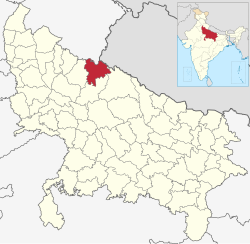
Bareilly division is one of the 18 administrative geographical unit of the northern Indian state of Uttar Pradesh. Bareilly city is the administrative headquarters of the division. Part of the Rohilkhand region, Bareilly division consists of four major districts in western Uttar Pradesh - Bareilly, Badaun, Pilibhit and Shahjahanpur.

<span class="mw-page-title-main">Budaun</span> City in Uttar Pradesh, India

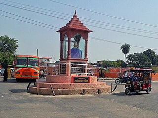
Budaun is a medieval city and headquarters of Budaun district, in the Indian state of Uttar Pradesh. It is located about a mile east of the Sot river, and 27 km north of the Ganges, in the Rohilkhand region of Uttar Pradesh. According to the 2011 census, it has a population of 159,221, which is projected at 161,555 at present. Budaun rose to historical importance as the capital of the Delhi Sultanate for four years from 1210 CE to 1214 CE during the reign of Sultan Iltutmish. It was the most important post of Northern Frontier during Mughal reign. Budaun is a big market, historically famous and religiously important city. Budaun is 230 km south-east of New Delhi and 245 km north-west of Lucknow, both taking about 6 hours by road.

<span class="mw-page-title-main">Budaun district</span> District of Uttar Pradesh in India

Badaun district is one of the districts of Uttar Pradesh state of India, with its headquarters in the town of Badaun. The district is part of the Bareilly division, and covers an area of 4,234 km2 (1,635 sq mi). According to legend, Budaun was named after the Ahir prince Budh.

<span class="mw-page-title-main">Pilibhit</span> City in Uttar Pradesh, India

Pilibhit is a city and a municipal board in Pilibhit district in the northern Indian state of Uttar Pradesh. Pilibhit is the north-easternmost district of Bareilly division, situated in the Rohilkhand region of the sub-Himalayan Plateau belt next to foothills of Sivalik Range on the boundary of Nepal, known for the origin of river Gomati and one of the most forest-rich areas in North India. Pilibhit was also known as Bansuri Nagari – the land of flutes, for making and exporting roughly 95% of India's flutes.

<span class="mw-page-title-main">Shahjahanpur district</span> District of Uttar Pradesh in India

Shahjahanpur is a district of Uttar Pradesh India. It is a part of Bareilly division. It was established in 1813 by the British Government. Previously it was a part of district Bareilly. Geographically the main town is Shahjahanpur which is its headquarters. Its 4 Tehsils are: Powayan, Tilhar, Jalalabad and Sadar.

<span class="mw-page-title-main">Lakhimpur Kheri district</span> District of Uttar Pradesh in India

Lakhimpur Kheri district is the largest district in Uttar Pradesh, India, on the border with Nepal. Its administrative capital is the city of Lakhimpur.

Bisalpur is a City and a municipal board situated nearby Pilibhit City in the Pilibhit district of the state of Uttar Pradesh, India. The town is known for its sugar factory as well as its annual Ram Leela and Dushera festival. Bisalpur is in between the two rivers, in West Doha river and in East katna river. Before formation of new District Pilibhit, Bisalpur was under the District Bareilly. In 1913 AD after formation of new District Pilibhit, Bisalpur has come under District Pilibhit Administration. this city is well connected with 03 major cities. Bisalpur is just 290 km away from National capital New Delhi and 250 km from the state capital Lucknow. Bisalpur is famous for Annual Ramleela Fest, Dubey Taalab, Guleshwarnath Temple, Dargah Hazrat Gazi kamaal Degree college and Nagaich Market. Bisalpur is known for many things and places and people of Bisalpur have contributed in various fields one such example is Freedom fight Raees Mohammad who was a freedom fighter and a military man resident of mohalla gyaspur he have won many medals for his extraordinary work he did for the country. he is well known for his charm and Character he played in the public domain now his generation resides in the Bisalpur mohalla gyaspur. Another important place is its railway station which has been modified for the broad gauge. This will help to get well connected with different cities of India.

Powayan or Pawayan is a town and a subdivisional headquarters in Shahjahanpur district in the Indian state of Uttar Pradesh, 27 km from Shahjahanpur, 47km from Tilhar. It is located in the fertile agricultural belt of Northern India and is 300 km from Delhi and 200 km from Lucknow.

Puranpur is a town and a municipal board in Pilibhit district in the Indian state of Uttar Pradesh. Puranpur is divided into 25 wards for which elections are held every 5 years. After independence and Partition of India the large numbers of Sikhs migrated and settled in the Puranpur Region. Due to dense Sikh population and their lifestyle, The area is also known as Mini Punjab as after Partition of India in 1947.Sikh people own their properties and lands in this area. There are numerous Sikh temples in Puranpur.

Rithora is a town and a nagar panchayat in Bareilly Tehsil of Bareilly district in the Indian state of Uttar Pradesh.

<span class="mw-page-title-main">Jahanabad, Pilibhit</span> Town in Uttar Pradesh, India

Jahanabad is a town and a nagar panchayat in Pilibhit district in the Indian state of Uttar Pradesh. Community Health Center (CHC) is situated near bazar Jagdeeshpur road. CHC is providing health facilities to community. CHC is under department of medical, health & family welfare. CHC Jahanabad is under block Lalaurikhera.

<span class="mw-page-title-main">Nawabganj, Bareilly</span> Town in Uttar Pradesh, India

Nawabganj is a Nagar palika and an administrative subdivision of Bareilly district in the Indian state of Uttar Pradesh. A Sub Divisional Magistrate, also called Sub Divisional Officer, or pargana-adhikari is the head official.

<span class="mw-page-title-main">Pilibhit Tiger Reserve</span> Tiger reserve Area in Uttar Pradesh, India

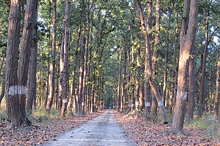
Pilibhit Tiger Reserve is located in Pilibhit district of Uttar Pradesh and was notified as a tiger reserve in 2014. It forms part of the Terai Arc Landscape in the upper Gangetic Plain along the India-Nepal border. The habitat is characterized by sal forests, tall grasslands and swamp maintained by periodic flooding from rivers. The Sharda Sagar Dam extending up to a length of 22 km (14 mi) is on the boundary of the reserve.

<span class="mw-page-title-main">Tourism in Uttar Pradesh</span> Overview of tourism in the Indian state of Uttar Pradesh

Situated in the northern part of India, bordering with the capital of India New Delhi, Uttar Pradesh is one of the most popular and an established tourist destination for both Indians and non-Indians alike in India. The most populous state of India, Uttar Pradesh contains many historical monuments and places of religious significance. Geographically, Uttar Pradesh is very diverse, with Himalayan foothills in the extreme north and the Gangetic Plain in the centre. It is also home of India's most visited sites, Hinduism's holiest city, Varanasi. Kumbh city, Prayagraj. Kathak, one of the eight forms of Indian classical dances, originated from Uttar Pradesh. Uttar Pradesh is at the heart of India, hence it is also known as The Heartland of India. Cuisine of Uttar Pradesh like Awadhi cuisine, Mughlai cuisine and Bhojpuri cuisine are very famous not only in India but also many places abroad.

Amkhiriya is a village in Block Amariya, Tehsil and District Pilibhit in the Indian state of Uttar Pradesh. Amkhiriya have some British Government historical Building. These British Government Buildings served as guest houses for British army and other British employees during the pre-independence era.

Barkhera Assembly constituency is one of the 403 constituencies of the Uttar Pradesh Legislative Assembly, India. It is a part of the Pilibhit district and one of the five assembly constituencies in the Pilibhit Lok Sabha constituency. First election in this assembly constituency was held in 1967 after the "DPACO (1967)" was passed in 1967. After the "Delimitation of Parliamentary and Assembly Constituencies Order" was passed in 2008, the constituency was assigned identification number 128.

Puranpur Assembly constituency is one of the 403 constituencies of the Uttar Pradesh Legislative Assembly, India. It is a part of the Pilibhit district and one of the five assembly constituencies in the Pilibhit Lok Sabha constituency. First election in this assembly constituency was held in 1962 after the "DPACO (1961)" was passed in 1961. After the "Delimitation of Parliamentary and Assembly Constituencies Order" was passed in 2008, the constituency was assigned identification number 129.

Puranpur Khas (Rural) is a village in Puranpur Tehsil, Pilibhit District, Uttar Pradesh, India. It sits near the northern border with Nepal, about 35 kilometres southeast of the district seat Pilibhit, and 1 kilometres southeast of the tehsil seat Puranpur. At the 2011 Census, the village's population was 35,948.

References

  1. 1 2 3 4 5 6 7 8 9 10 11 12 13 14 15 16 17 18 19 20 21 22 23 24 25 26 27 28 29 30 31 32 33 34 35 36 37 38 39 40 Nevill, H.R. (1909). Pilibhit: A Gazetteer, Being Volume XVIII Of The District Gazetteers Of The United Provinces Of Agra And Oudh. Allahabad: Government Press. pp. 115–6, 147–67. Retrieved 12 April 2021.
  2. "Untitled Page". Archived from the original on 3 March 2016. Retrieved 23 December 2020.
  3. "Pilibhit tiger reserve gets Central nod | Lucknow News". The Times of India . Archived from the original on 21 October 2012.
  4. "Decadal Variation In Population Since 1901". Archived from the original on 8 August 2019. Retrieved 12 August 2019.
  5. 1 2 "Table C-16 Population by Mother Tongue: Uttar Pradesh". www.censusindia.gov.in. Registrar General and Census Commissioner of India. Archived from the original on 20 September 2022. Retrieved 8 August 2022.
  6. "Table C-01 Population by Religion: Uttar Pradesh". censusindia.gov.in. Registrar General and Census Commissioner of India. 2011. Archived from the original on 20 September 2022. Retrieved 5 December 2023.
  7. 1 2 3 4 5 6 "District Census Handbook: Pilbhit" (PDF). censusindia.gov.in. Registrar General and Census Commissioner of India. 2011.
  8. US Directorate of Intelligence. "Country Comparison:Population". Archived from the original on 13 June 2007. Retrieved 1 October 2011. Slovenia 2,000,092 July 2011 est.
  9. "2010 Resident Population Data". U. S. Census Bureau. Archived from the original on 20 December 2012. Retrieved 30 September 2011. New Mexico - 2,059,179
  10. "Chuka Beach – Fascinating Offbeat Tourist Place in Pilibhit UP". chaloghumane.com. Archived from the original on 23 May 2021. Retrieved 19 March 2021.
  11. "Discover Pilibhit District". Pilibhit.nic.in. 1 July 1971. Archived from the original on 19 September 2008. Retrieved 13 June 2012.
  12. "The Population in 2011" (PDF). Government of India. Archived (PDF) from the original on 26 June 2011. Retrieved 7 May 2011.

28°33′N80°06′E / 28.550°N 80.100°E / 28.550; 80.100