Oudtshoorn, the "ostrich capital of the world", is a town in the Western Cape province of South Africa, located between the Swartberg mountains to the north and the Outeniqua Mountains to the south. Two ostrich-feather booms, during 1865–1870 and 1900–1914, truly established the settlement. With approximately 60,000 inhabitants, it is the largest town in the Little Karoo region. The town's economy is primarily reliant on the ostrich farming and tourism industries. Oudtshoorn is home to the world's largest ostrich population, with a number of specialised ostrich breeding farms, such as the Safari Show Farm and the Highgate Ostrich Show Farm, as told by Mnr. Pierre D. Toit.

The Swartberg mountains are a mountain range in the Western Cape province of South Africa. It is composed of two main mountain chains running roughly east–west along the northern edge of the semi-arid Little Karoo. To the north of the range lies the other large semi-arid area in South Africa, the Great Karoo. Most of the Swartberg Mountains are above 2000 m high, making them the tallest mountains in the Western Cape. It is also one of the longest, spanning some 230 km from south of Laingsburg in the west to between Willowmore and Uniondale in the east. Geologically, these mountains are part of the Cape Fold Belt.
The R328 is a Regional Route in Western Cape, South Africa that connects Mossel Bay in the south to Prince Albert in the north via Oudtshoorn.

Sof Omar Caves is the longest cave in Ethiopia at 15.1 kilometres (9.4 mi) long. When surveyed in 1972, it was the longest cave in Africa. Since then explorations in Madagascar and Algeria have overtaken it. It is situated to the east of Ginnir, in the East Bale Zone of the Oromia Region in southeastern Ethiopia, through which the Weyib River flows. It sinks at the Ayiew Maco entrance and reappears at the Holuca resurgence 1 kilometre (0.62 mi) away. According to tradition Sof Omar was the name of a Muslim holy man who lived in the area and Ayiew the name of his daughter. Maco and Holuca are local names for 'name' and "cave", respectively. Long a religious centre, it is sacred both to Islam and the local Oromo traditional religion. The caves are known for their many pillars, particularly in the "Chamber of Columns".
Lamb Leer is a 14.59 hectare geological Site of Special Scientific Interest between East Harptree and Priddy in the Mendip Hills, Somerset, notified in 1983. The cavern is a fragment of a very ancient major cave system which now contains one of the largest chambers in the Mendip Hills.
The Bothongo WonderCave in Kromdraai, Gauteng, South Africa is situated within the Bothongo Rhino & Lion Nature Reserve in the Cradle of Humankind, a UNESCO World Heritage Site. The cave is the third-largest cave chamber in the country. It is 5-10 million years old. The single chamber has an area of 46,000 square metres (500,000 sq ft), and is 125 by 154 metres.

Koněprusy Caves is a cave system in the heart of the limestone region known as Bohemian Karst in the Central Bohemian Region of the Czech Republic. It is located in the municipality of Koněprusy, about 25 kilometres (16 mi) southwest of Prague, 6 km (3.7 mi) south of Beroun. With the length of 2 km (1.2 mi) and vertical range of 70 m (230 ft), it is the largest cave system in Bohemia.
Rumbling Hole is a cave on Leck Fell, in Lancashire, England. Its entrance is a 50-metre (160 ft) deep fenced shaft, and it rapidly descends a series of pitches to a low aqueous passage that has been connected to Lost Johns' Cave. It is part of the Three Counties System, an 87-kilometre (54 mi) cave system that spans the borders of Cumbria, Lancashire, and North Yorkshire.
Langcliffe Pot is a cave system on the slopes of Great Whernside in Upper Wharfedale, about 3 kilometres (1.9 mi) SSE of Kettlewell in North Yorkshire. It is part of the Black Keld Site of Special Scientific Interest where the "underground drainage system which feeds the stream resurgence at Black Keld is one of the largest and deepest in Britain, although only a small proportion of its cave passages are accessible at present." Mossdale Caverns is also part of the Black Keld SSSI. Although a considerable length of passage has been explored in Langcliffe Pot, the current end is over 170 metres (560 ft) above the resurgence, and over 4 kilometres (2.5 mi) in distance. A trip to the far end has been described as "one of the most serious undertakings in British caving".

Short Drop Cave and Gavel Pot are different entrances into the same cave system on Leck Fell, in Lancashire, England. The main top entrance, Short Drop Cave, is a small hole in a fenced off shakehole near the main stream sink; Gavel Pot, a window into the system, is a large fenced shakehole some 40-metre (130 ft) deep requiring tackle to descend. There are two other smaller entrances into Short Drop Cave. At its base the system links via a sump with Lost Johns' Cave, and is part of the Three Counties System, an 87 kilometres (54 mi) cave system which spans the borders of Cumbria, Lancashire, and North Yorkshire.
Grotte de Lombrives or Lombrives Cave is a large natural cavern located in Ornolac-Ussat-les-Bains, at the eastern edge of the Pyrénées Ariégeoises Natural Regional Park, in the Ariège department of Occitanie, in southwestern France.
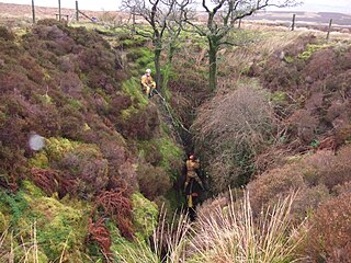
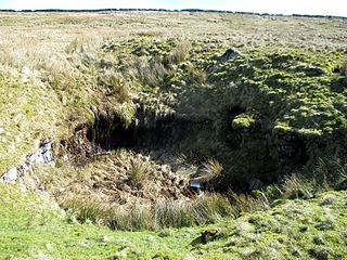
Disappointment Pot is one of the entrances to the Gaping Gill cave system, located in a steep grassy shakehole some 120 metres (130 yd) south-east of Gaping Gill Main Shaft. Its mainly narrow stream passage descends a number of small shafts to enter the main system as a major inlet of Hensler's Master Cave. It lies within the designated Ingleborough Site of Special Scientific Interest.

Rat Hole is one of the entrances to the Gaping Gill cave system, located in the north bank of Fell Beck 30 metres (33 yd) upstream of Gaping Gill Main Shaft. A small, awkward, tube-like passage descends into a stream passage, and hence to a 100-metre (330 ft) shaft into Gaping Gill Main Chamber. The sharp and loose nature of the rock, and the quantity of water prevented full exploration for over 80 years, but the current route is described in one guide book as "a technical and exhilarating adventure". It lies within the designated Ingleborough Site of Special Scientific Interest.

Death's Head Hole is a cave on Leck Fell, in Lancashire, England. Its entrance is a 64-metre (210 ft) deep shaft. It leads into Lost Johns' Cave and is part of the Three Counties System, an 87-kilometre (54 mi) cave system which spans the borders of Cumbria, Lancashire, and North Yorkshire.
Long Drop Cave is a cave on Leck Fell, in Lancashire, England. It leads into Death's Head Hole, and is part of the Three Counties System, an 87-kilometre (54 mi) cave system which spans the borders of Cumbria, Lancashire, and North Yorkshire.
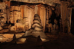
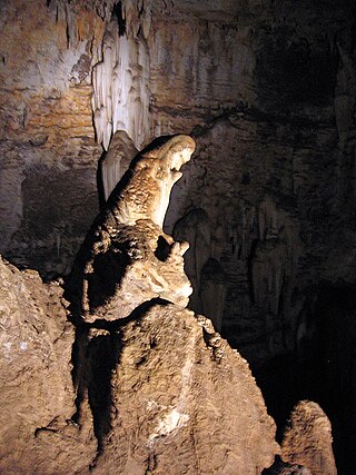
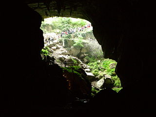
Boomplaas Cave is located in the Cango Valley in the foothills of the Swartberg mountain range, north of Oudtshoorn, Eden District Municipality in the Western Cape Province, South Africa. It has a 5 m (16 ft) deep stratified archaeological sequence of human presence, occupation and hunter-gatherer/herder acculturation that might date back as far as 80,000 years. The site's documentation contributed to the reconstruction of palaeo-environments in the context of changes in climate within periods of the Late Pleistocene and the Holocene. The cave has served multiple functions during its occupation, such as a kraal (enclosure) for animals, a place for the storage of oil rich fruits and as a hunting camp. Circular stone hearths and calcified dung remains of domesticated sheep as well as stone adzes and pottery art were excavated indicating that humans lived at the site and kept animals.
The Kogelbeen Cave forms part of eight caves on the dolomitic Ghaap Plateau of the Northern Cape, South Africa. It is commonly known as Kogelbeengrotte in Afrikaans. The cave is located on Kogelbeen Farm in Pixley ka Seme District Municipality. It is the longest known cave in the Northern Cape with a length of 788 meters. The Kogelbeen Cave has a diverse fauna with over 39 species living in five life zones within the cave.

Swinsto Cave is a limestone cave in West Kingsdale, North Yorkshire, England. It leads into Kingsdale Master Cave and it is popular with cavers as it is possible to descend by abseiling down the pitches, retrieving the rope each time, and exiting through Valley Entrance of Kingsdale Master Cave at the base of the hill. It is part of a 27-kilometre (17 mi) long cave system that drains both flanks of Kingsdale.
Ockert Stefanus "Okkie" Terblanche is a South African politician and retired police general serving as the Shadow Deputy Minister of Police since June 2019. He has been a Member of the National Assembly since May 2019. He represented the Western Cape in the National Council of Provinces (NCOP) from October 2015 to May 2019. Terblanche is a member of the Democratic Alliance (DA).

The Long Kin East Cave - Rift Pot system is a limestone cave system on the southern flanks of Ingleborough, North Yorkshire in England lying within the designated Ingleborough Site of Special Scientific Interest. Long Kin East Cave starts as a long meandering stream passage but then plummets down a 58-metre (190 ft) deep shaft when it meets a shattered fault into which Rift Pot also descends. At the bottom, the stream flows through some low canals and sumps, to eventually emerge at Austwick Beck Head in Crummackdale.