Cape Jourimain is an area made of two islands and a section of mainland along the southwestern shore of the Northumberland Strait, three kilometres west of New Brunswick's easternmost point at Cape Tormentine. The two islands, Jourimain and Trenholm, have been connected to the mainland since 1966 by an artificial causeway. Cape Jourimain is the historic crossing point from New Brunswick (NB) to Prince Edward Island (PEI) and is host to the western end of the Confederation Bridge, Canada's longest fixed-link crossing. In 1980, the two islands, including a section of mainland, were designated as a National Wildlife Area (NWA) [1] and in 2001 the Cape Jourimain Nature Centre, operated by a charitable nonprofit organization, was opened to the public.[2]
The Cape Jourimain area has been visited by humans, in some capacity, for at least 4,000 years. Evidence suggests that the Mi'kmaq hunted walrus, seal, and a variety of other species along the coast and that they used sea canoes to cross the Northumberland Strait from Cape Jourimain to PEI.[3] Archaeological evidence suggests that the area was not settled by native peoples, but was instead used as a shared space due to its importance as a place of crossing.
Jacques Cartier landed on PEI in 1534; believing it was the mainland, he did not venture across the Northumberland Strait to the Jourimain Islands. Cape Tormentin, the original name for the greater Jourimain area, was first used by Nicolas Denys, a French merchant, in 1672, who likely learned about the area from Mi'kmaq fishermen.[4] In the 1830s, the name Cape Tormentine was shifted to another community further down the coast and the area became known as the Jourimain Islands, which is theorized to be a misspelling of germain, a French word for "sibling".[5]
In 1827, the first winter crossing from Cape Traverse to Cape Jourimain took place. This route proved easier than the previous Wood Islands to Pictou route, and a deal was struck with Cape Traverse to have the permanent mail and passenger service run between the capes.
Special boats with runners were designed for crossing sections of board ice [7] and the journey become famous for its harrowing conditions. In the 1880s, the iceboat service was relocated to Cape Tormentine and in 1917, the service was discontinued due to advances in the ice-breaking capabilities of ferries.
In 1811, Eliphalet and Hannah Allen, two of the first settlers after British occupation, built their home on Jourimain Island. In 1827, they opened the Allen Hotel to serve the crew and passengers [8] of the iceboats, and in later years, provided room-and-board to workers of the lobster cannery, which opened on Jourimain Island in the late 1800s. The cannery, which was located between what is now Gunning Point and the Confederation Bridge, was operated by the Portland Packing Company and was primarily staffed by young Acadian women.
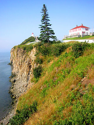
Cape Jourimain Lighthouse.
Throughout the 1870s and early 1880s, as a result of the iceboat service, the Allen Hotel, and a thriving lobster industry, Cape Jourimain reached its economic peak. However, by the 1890s, with the completion of a rail line to Cape Tormentine, as well as a new pier which was constructed in 1886, economic activity began to decline. In 1905, due to a decrease in lobster catches and competition from other canneries, the Cape Jourimain lobster cannery officially closed.
Cape Jourimain lighthouse
In 1870, after nearly 30 years of petitions, a 15.5-m lighthouse was constructed at Cape Jourimain to help sailors navigate the narrow Strait. Lewis Wells looked after the lighthouse over the first winter, which remained non-operational until a temporary lighting apparatus was installed in April 1871. On May 15, John Bent was appointed as the first permanent lighthouse keeper, beginning a dynasty of lighthouse keepers spanning four generations.[9]
In 1958, the light was fully automated, ending the service of the final lighthouse keeper, Merrill Trenholm. The lighthouse continued to operate for another 39 years before officially closing in 1997 when the Cape Tormentine ferry service was decommissioned as a result of the opening of the Confederation Bridge.
In 2001, the Cape Jourimain Nature Centre entered into negotiations with the Government of Canada to acquire the structure, and in 2015, ownership was officially transferred. In 2016, the lighthouse was moved for the third time throughout its history in an effort to protect it from coastal erosion,[10] and in 2017, extensive renovations were completed in a bid to save the structure years of deterioration.
National wildlife area
In the 1960s, a causeway was developed between the Jourimain Islands in an aborted attempt to build a fixed-link to PEI, cutting the saltwater marshes in half.[11] This resulted in the establishment of a brackish marsh,[12] which created valuable habitat for migrating ducks and other coastal wildlife.
Periodic discussions regarding the installation of a fixed-link to connect PEI to the mainland had been ongoing since the late 1800s. Early proposals looked at developing a railway tunnel under the Strait, but this idea was later abandoned due to concerns over engineering and costs.
In the 1950s, a plan was proposed to build a causeway to PEI, and in 1966, the Government of Canada began moving forward with development, getting so far as to construct a causeway connecting Trenholm and Jourimain Island. However, this endeavour was ultimately aborted due to rising costs.[16] It wasn't until 1987, after receiving a number of development proposals, that the Government began conducting feasibility studies for a fixed-link crossing.
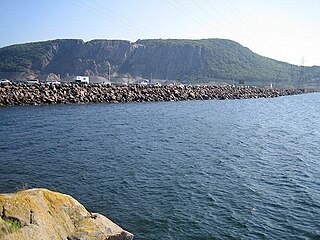
View of the Confederation Bridge from Gunning Trail.
In 1988, a plebiscite was conducted on PEI, which resulted in a majority vote in favour of constructing a bridge.[17] This would ultimately result in the demise of the Cape Tormentine ferry service, which had been operating in some capacity since the turn of the 20th century. This proved to be a significant point of contention within nearby communities in both NB and PEI, with many voicing their concerns over the impacts that its removal would have on local jobs. Cape Jourimain in NB and Borden-Carleton in PEI were selected as the two end points due to these areas being the shortest distance between the two provinces. In 1992, after a number of studies and an extensive environmental impact assessment,[18] Strait Crossing Joint Venture was granted the development contract and construction began in 1993.
The 12.9-km cantilever bridge was completed in November 1996 and officially opened to the public on May 31, 1997.[17] On opening day, the bridge hosted an inaugural run, which had for 20,000 attendees.[19] It has since become a notable tourist attraction and is famous for being the longest bridge to cross ice-covered water.
Cape Jourimain Nature Centre
Cape Jourimain Interpretive Centre
In 1997, the same year that the Confederation Bridge opened, a group of passionate experts and local property owners established the Cape Jourimain Nature Centre Incorporated, a charitable nonprofit organization dedicated to providing eco-tourism opportunities and educational services to the public.[20]
The organization was granted a lease for a section of the NWA near the Route 16 highway,[20] where they were given permission to build and operate an eco-friendly interpretation facility which comprises an entry pavilion, interpretive centre, restaurant, observation tower, a network of trails, and a number of other amenities. The centre officially opened to the public in June, 2001.
Related Research Articles
The Bay of Fundy is a bay between the Canadian provinces of New Brunswick and Nova Scotia, with a small portion touching the U.S. state of Maine. It is an arm of the Gulf of Maine. Its tidal range is the highest in the world. The name is probably a corruption of the French word fendu, meaning 'split'.
The Confederation Bridge is a box girder bridge carrying the Trans-Canada Highway across the Abegweit Passage of the Northumberland Strait, linking the province of Prince Edward Island with the mainland province of New Brunswick. Opened May 31, 1997, the 12.9-kilometre (8.0 mi) bridge is Canada's longest bridge and the world's longest bridge over ice-covered water.
The Canso Causeway is a 1,385 m (4,544 ft) rock-fill causeway crossing the Strait of Canso, connecting Cape Breton Island by road to the Nova Scotia peninsula. Its crest thickness is 40 m (130 ft), carrying the two vehicle traffic lanes of the Trans-Canada Highway, Nova Scotia Highway 104 on the mainland side, and Nova Scotia Highway 105 on the Cape Breton side, as well as the single track mainline of the Cape Breton and Central Nova Scotia Railway.
Sackville is a former town in southeastern New Brunswick, Canada. It held town status prior to 2023 and is now part of the town of Tantramar.
A Northumberland Strait iceboat is a rowing boat, typically 5 metres in length, 2 metres in beam, with runners fastened to the hull for dragging over sea ice.
The Prince Edward Island Railway (PEIR) was a historic Canadian railway in Prince Edward Island (PEI). The railway ran tip-to-tip on the island, from Tignish in the west to Elmira in the east, with major spurs serving Borden-Carleton's train ferry dock, the capital in Charlottetown, Montague and Georgetown and the original eastern terminus at Souris. A major spur from Charlottetown served Murray Harbour on the south coast.
Northumberland Ferries Limited (NFL) is a ferry company operating in eastern Canada and headquartered in Charlottetown, Prince Edward Island. NFL is also the owner of subsidiary Bay Ferries Limited through its holding company.
The Isthmus of Chignecto is an isthmus bordering the Maritime provinces of New Brunswick and Nova Scotia that connects the Nova Scotia peninsula with North America.
Route 16 is a 2-lane highway in the Canadian province of New Brunswick. The 52 km (32 mi) route begins at a T intersection with Aulac Road at Aulac and ends at the western abutment of the Confederation Bridge at Cape Jourimain.
Borden-Carleton is a town in Prince County in the Canadian province of Prince Edward Island. It is situated on the south shore fronting on the Northumberland Strait. The town was originally incorporated as a community on April 12, 1995, through the amalgamation of the town of Borden and the community of Carleton. The town of Borden opted to demote its status to a community in light of a declining tax base with the pending completion of the Confederation Bridge and the closure of the Marine Atlantic ferry service. Borden-Carleton became a town on July 31, 2012.
Port Elgin is a former Canadian village in Westmorland County, New Brunswick. It is located near the Nova Scotia border at the mouth of the Gaspereaux River where it empties into the Northumberland Strait's Baie Verte and is now part of the rural community of Strait Shores.
Wood Islands is a rural farming and fishing community located in southeastern Queens County, Prince Edward Island on the Northumberland Strait. It takes its name from several small forested islands, then located several hundred metres offshore in the Northumberland Strait. The community of Wood Islands falls within the larger PEI Township of Lot 62, which had a population in 2011 of 470 residents, a 13% decrease from the 2006 census count of 540. While the named islands are located on maps by Jacques-Nicolas Bellin: Karte Bellin, 1744: 'I a Bova' and Louis Franquet: Cartes Franquet, 1751: 'Isle a Bois', it was Samuel Johannes Holland who correctly surveyed and depicted the islands, about their basin. The 'European' settlement of Wood Islands began in 1803, but saw its most noted arrivals in 1807 with the arrival, after wintering in Pinette, of a large party of Scottish settlers from the Spencer.
Aulac is a Canadian community in Westmorland County, New Brunswick. It is located between the college town of Sackville and the provincial border with Nova Scotia.
There are two major national parks. The warmest salt water beaches north of Virginia can be found on the Northumberland Strait, at Parlee Beach in Shediac. New Brunswick's signature natural attraction are only a half hour's drive down the Petitcodiac river valley. The Confederation Bridge to Prince Edward Island is only an hour's drive east of Moncton.
Route 955 is a Canadian highway in Westmorland County, New Brunswick.
Botsford is a civil parish in Westmorland County, New Brunswick, Canada.
Baie Verte is a 770 km2 (300 sq mi) Canadian bay located on the north shore of Nova Scotia and eastern shore of New Brunswick. It is a sub-basin of the Northumberland Strait.
The New Brunswick and Prince Edward Island Railway, was a company incorporated in 1874 to build a line from the Prince Edward Island ferry terminal at Cape Tormentine, New Brunswick to Sackville where it would connect to the Intercolonial Railway.
↑ Cape Jourimain Nature Centre (2001). Mand-Made Marshes The Brackish Marshes are Truly a Treasure.
↑ Harries, H., Mackinnon, C.M., Ellingwood, C. (1991). The Flora of Cape Jourirnain National Wildlife Area, New Brunswick. Technical Report Series No. 129. Sackville: Canadian Wildlife Service, Atlantic Region. p.3.{{cite book}}: CS1 maint: multiple names: authors list (link)
↑ Harries, H, Mackinnon, C.M., Ellingwood, C. (1991). The Flora of Cape Jourirnain National Wildlife Area, New Brunswick. Technical Report Series No. 129. Sackville: Canadian Wildlife Service, Atlantic Region. p.1.{{cite book}}: CS1 maint: multiple names: authors list (link)
↑ Government of Canada, Government of Canada (2013). Cape Jourimain National Wildlife Area. Environment and Climate Change Canada.
1 2 Straight Crossing Bridge Limited (2018). "Confederation Bridge". confederationbridge.com. Archived from the original on 2015-11-12. Retrieved 2018-08-20.
This page is based on this Wikipedia article Text is available under the CC BY-SA 4.0 license; additional terms may apply. Images, videos and audio are available under their respective licenses.