Central place theory is an urban geographicaltheory that seeks to explain the number, size and range of market services in a commercial system or human settlements in a residential system.[1] It was introduced in 1933 to explain the spatial distribution of cities across the landscape.[2] The theory was first analyzed by German geographer Walter Christaller, who asserted that settlements simply functioned as 'central places' providing economic services to surrounding areas.[1] Christaller explained that a large number of small settlements will be situated relatively close to one another for efficiency, and because people don't want to travel far for everyday needs, like getting bread from a bakery. But people would travel further for more expensive and infrequent purchases or specialized goods and services which would be located in larger settlements that are farther apart.
all settlements are equidistant and exist in a triangular lattice pattern
evenly distributed resources
distance decay mechanism
perfect competition and all sellers are economic people maximizing their profits
consumers are of the same income level and same shopping behaviour
all consumers have a similar purchasing power and demand for goods and services.
Consumers visit the nearest central places that provide the function which they demand. They minimize the distance to be travelled
no provider of goods or services is able to earn excess profit (each supplier has a monopoly over a hinterland)
Therefore, the trade areas of these central places who provide a particular good or service must all be of equal size
there is only one type of transport and this would be equally easy in all directions
transport cost is directly proportional to distance travelled
These assumptions generally mean that the theory has no utility beyond abstract discussions.
The theory then relied on two concepts: threshold and range.
Threshold is the minimum market (population or income) needed to bring about the selling of a particular good or service.
Range is the maximum distance consumers are prepared to travel to acquire goods - at some point the cost or inconvenience will outweigh the need for the good.
The result of these consumer preferences is that a system of centers of various sizes will emerge. Each center will supply particular types of goods forming levels of hierarchy. In the functional hierarchies, generalizations can be made regarding the spacing, size and function of settlements.
The larger the settlements are in size, the fewer in number they will be, i.e. there are many small villages, but few large cities.
The larger the settlements grow in size, the greater the distance between them, i.e. villages are usually found close together, while cities are spaced much further apart.
As a settlement increases in size, the range and number of its functions will increase .
As a settlement increases in size, the number of higher-order services will also increase, i.e. a greater degree of specialization occurs in the services.
The higher the order of the goods and services (more durable, valuable and variable), the larger the range of the goods and services, the longer the distance people are willing to travel to acquire them.
At the base of the hierarchy pyramid are shopping centres, newsagents etc. which sell low order goods. These centres are small. At the top of the pyramid are centres selling high order goods. These centres are large. Examples for low order goods and services are: newspaper stalls, groceries, bakeries and post offices. Examples for high order goods and services include jewelry, large shopping malls and arcades. They are supported by a much larger threshold population and demand.
Predictions
He deduced that settlements would tend to form in a triangular/hexagonal lattice, as it is the most efficient pattern to serve areas without any overlap.[1]
In the orderly arrangement of an urban hierarchy, seven different principal orders of settlement have been identified by Christaller, providing different groups of goods and services. Settlement are regularly spaced - equidistant spacing between same order centers, with larger centers farther apart than smaller centers. Settlements have hexagonal market areas, and are most efficient in number and functions.
The different layouts predicted by Christaller have K-values which show how much the sphere of influence of the central places takes in — the central place itself counts as 1 and each portion of a satellite counts as its portion:
K = 3 marketing principle
K = 3 principle
According to the marketing principle K = 3, the market area of a higher-order place (node) occupies one-third of the market area of each of the consecutive lower size place (node) that lies on its neighbour; the lower size nodes (6 in numbers and second larger circles) are located at the corner of a largest hexagon around low value the high-order settlement. Each high-order settlement gets one-third of each satellite settlement (which are 6 in total), thus K=1+6×1⁄3=3.
However, in this K = 3 marketing network the distance traveled is minimized.
K = 4 transporting/traffic principle
K = 4 principle
According to K' 4 transport principle, the market area of a higher-order place includes a half of the market area of each of the six neighbouring lower-order places, as they are located on the edges of hexagons around the high-order settlements. This generates a hierarchy of central places which results in the most efficient transport network. There are maximum central places possible located on the main transport routes connecting the higher order center. The transportation principle involves the minimization of the length of roads connecting central places at all hierarchy levels. In this system of nesting, the lower order centres are all located along the roads linking the higher order centres. This alignment of places along a road leads to minimization of road length. However, for each higher order centre, there are now four centres of immediate lower order, as opposed to three centres under the marketing principle.
K = 7 administrative principle
K = 7 principle
According to K = 7 administrative principle (or political-social principle), settlements are nested according to sevens. The market areas of the smaller settlements are completely enclosed within the market area of the larger settlement. Since tributary areas cannot be split administratively, they must be allocated exclusively to a single higher-order place. Efficient administration is the control principle in this hierarchy.
Evaluation
The validity of the place theory may vary with local factors, such as climate, topography, history of development, technological improvement and personal preference of consumers and suppliers. However, it is still possible to discern Christaller patterns in most distributions of urban centres, even though these patterns will often be distorted by the terrain or imperfect because of suboptimal (with regard to the optimal distribution of centres) historical development decisions.
Economic status of consumers in an area is also important. Consumers of higher economic status tend to be more mobile and therefore bypass centers providing only lower order goods. The application of central place theory must be tempered by an awareness of such factors when planning shopping center space location.
Purchasing power and density affect the spacing of centers and hierarchical arrangements. Sufficient densities will allow, for example, a grocery store, a lower order function, to survive in an isolated location.
Factors shaping the extent of market areas:
Land use: industrial areas can provide little in the way of a consuming population
Poor accessibility: this can limit the extent of a center's market area
Competition: this limits the extent of market areas in all directions
Technology: high mobility afforded by the automobile allows overlapping of market areas
Market area studies provide another technique for using central place theory as a retail location planning tool. The hierarchy of shopping centers has been widely used within the planning of "new towns". In this new town, the hierarchy of business centers is evident. One main shopping center provides mostly durable goods (higher order); district and local shopping centers supply, increasingly, convenience (lower order) goods. These centers provided for in the new town plan are not free from outside competition. The impacts of surrounding existing centers on the new town centers cannot be ignored.
Examples
Satellite images of American Midwest shows settlements in different levels that are consistent with the Central place theory
The newly reclaimed polders of the Netherlands provide an isotropic plane on which settlements have developed and in certain areas 6 small towns can be seen surrounding a larger town, especially in the Noord-Oostpolder and Flevoland.
The Fens of East Anglia in the UK also provide a large expanse of flat land with no natural barriers to settlement development. Cambridge is a good example of a K=4 Transport Model Central Place, although it is surrounded by 7, rather than 6, settlements. Each satellite is 10–15 miles from Cambridge and each lies on a major road leading out of Cambridge:
As all of the satellite settlements are on transport links, this is a good example of a K=4 CPT model (although in this case it is K=4.5 due to 7 rather than 6 settlements).
Another example of the use of CPT was in the delineation of Medical Care Regions in California. A hierarchy of primary, secondary and tertiary care cities was described, and the population size and income needed to support each medical care specialty in California determined.
Criticism
The central place theory has been criticized for being static; it does not incorporate the temporal aspect in the development of central places. Furthermore, the theory holds up well when it comes to agricultural areas, but not industrial or postindustrial areas due to their diversified nature of various services or their varied distribution of natural resources.
Newer developments: a dynamic concept for CPT
Newer theoretical developments have shown that it is possible to overcome the static aspect of CPT. Veneris (1984) developed a theoretical model which starts with (a) a system of evenly distributed ("medieval") towns; (b) new economic activities are located in some towns thus causing differentiation and evolution into a hierarchical ("industrial") city system; (c) further differentiation leads into a post-hierarchical ("postindustrial") city system.
This evolution can be modelled by means of the three major CPT theories: stage (a) is a system of von Thünen "isolated states"; stage (b) is a Christallerian hierarchical system; stage (c) is a Löschian post-hierarchical system. Furthermore, stage (b) corresponds to Christopher Alexander's "tree" city, while (c) is similar to his "lattice" system (following his dictum "the city is not a tree").
The importance of a city and other theoretical considerations
According to Margot Smith, Walter Christaller erred in his development of CPT in 1930 by using size of population and number of telephones in determining the importance of a city. Smith recognized that although population size was important to the area served by a city, the number of kinds of services offered there was more important as a measure of the importance of a city in attracting consumers. In applying CPT to describe the delivery of medical care in California, Smith counted the number of physician specialties to determine the importance of a city in the delivery of medical care.
Christaller also erred in the assumption that cities "emerge". In California and much of the United States, many cities were situated by the railroads at the time the tracks were laid. In California, towns founded by the railroads were 12 miles apart, the amount of track a section crew could maintain in the 1850s; larger towns were 60 miles apart, the distance a steam engine could travel before needing water. Older towns were founded a day's horse ride apart by the Spanish priests who founded early missions.
In medical care regions described by Smith, there is a hierarchy of services, with primary care ideally distributed throughout an area, middle sized cities offering secondary care, and metropolitan areas with tertiary care. Income, size of population, population demographics, distance to the next service center, all had an influence on the number and kind of specialists located in a population center. (Smith, 1977, 1979)
For example, orthopedic surgeons are found in ski areas, obstetricians in the suburbs, and boutique specialties such as hypnosis, plastic surgery, psychiatry are more likely to be found in high income areas. It was possible to estimate the size of population (threshold) needed to support a specialty, and also to link specialties that needed to cooperate and locate near each other, such as hematology, oncology, and pathology, or cardiology, thoracic surgery and pulmonology.
Her work is important for the study of physician location—where physicians choose to practice and where their practices will have a sufficient population size to support them. The income level of the population determines whether sufficient physicians will practice in an area and whether public subsidy is needed to maintain the health of the population.
The distribution of medical care in California followed patterns having to do with the settlement of cities. Cities and their hinterlands having characteristics of the traffic principle (see K=4 above) usually have six thoroughfares through them—the thoroughfares including highways, rivers, railroads, and canals. They are most efficient and can deliver the lowest cost services because transportation is cheaper. Those having settled on the market principle (K=3 above) have more expensive services and goods, as they were founded at times when transportation was more primitive. In Appalachia, for example, the market principle still prevails and rural medical care is much more expensive.
Making central place theory operational
CPT is often criticized as being "unrealistic". However, several studies show that it can describe existing urban systems. An important issue is that Christaller's original formulation is incorrect in several ways (Smith). These errors become apparent if we try to make CPT "operational", that is if we try to derive numerical data out of the theoretical schemata. These problems have been identified for by Veneris (1984) and subsequently by Openshaw and Veneris (2003), who provided also theoretically sound and consistent solutions, based on a K=3, 37-centre CP system:
Closure problem. Christaller's original scheme implies an infinite landscape. Although each market has finite size, the total system has no boundaries to it. Neither Christaller, nor the early related literature provide any guidance as to how the system can be "contained". Openshaw and Veneris (2003) identified three different types of closure, namely (a) isolated state, (b) territorial closure and (c) functional closure. Each closure type implies different population patterns.
Generating trips. Following the basic Christallerian logic and the closure types identified, Openshaw and Veneris (2003) calculate trip patterns between the 27 centres.
Calculating inter- and intra-zonal costs/distances. Christaller assumed freedom of movement in all directions, which would imply "airline" distances between centres. At the same time, he provided specific road networks for the CP system, which do not allow for airline distances. This is a major flaw which neither Christaller, nor early related literature have identified. Openshaw and Veneris (2003) calculate costs/distances which are consistent with the Christallerian principles.
Central place theory and spatial interaction models
It was once thought that central place theory is not compatible with spatial interaction models (SIM). It is paradoxical however that some times towns or shopping centres are planned with CPT, and subsequently evaluated with SIM.
Openshaw and Veneris (2003) succeeded in linking these two major regional theories in a clear and theoretically consistent way: using the data they derived from the operationalization of CPT, they experimented with several SIM. Following a thorough investigation via computer simulation, they reached important theoretical and practical conclusions.
Smith was able to delineate medical care regions (the range), describe the hierarchy of medical services, the population base required of each medical specialty (threshold), the efficiency of regions, and the importance of how an area was settled to the delivery of medical care, that is, according to traffic, market or administrative principles.
A supermarket is a self-service shop offering a wide variety of food, beverages and household products, organized into sections. This kind of store is larger and has a wider selection than earlier grocery stores, but is smaller and more limited in the range of merchandise than a hypermarket or big-box market. In everyday United States usage, however, "grocery store" is often used to mean "supermarket".
A town is a type of a human settlement. Towns are generally larger than villages and smaller than cities, though the criteria to distinguish between them vary considerably in different parts of the world.
Shopping is an activity in which a customer browses the available goods or services presented by one or more retailers with the potential intent to purchase a suitable selection of them. A typology of shopper types has been developed by scholars which identifies one group of shoppers as recreational shoppers, that is, those who enjoy shopping and view it as a leisure activity.
A market town is a settlement most common in Europe that obtained by custom or royal charter, in the Middle Ages, a market right, which allowed it to host a regular market; this distinguished it from a village or city. In Britain, small rural towns with a hinterland of villages are still commonly called market towns, as sometimes reflected in their names.
Health economics is a branch of economics concerned with issues related to efficiency, effectiveness, value and behavior in the production and consumption of health and healthcare. Health economics is important in determining how to improve health outcomes and lifestyle patterns through interactions between individuals, healthcare providers and clinical settings. In broad terms, health economists study the functioning of healthcare systems and health-affecting behaviors such as smoking, diabetes, and obesity.
A market basket or commodity bundle is a fixed list of items, in given proportions. Its most common use is to track the progress of inflation in an economy or specific market. That is, to measure the changes in the value of money over time. A market basket is also used with the theory of purchasing price parity to measure the value of money in different places.
An economic system, or economic order, is a system of production, resource allocation and distribution of goods and services within a society. It includes the combination of the various institutions, agencies, entities, decision-making processes, and patterns of consumption that comprise the economic structure of a given community.
Walter Christaller was a German geographer whose principal contribution to the discipline is central place theory, first published in 1933. This groundbreaking theory was the foundation of the study of cities as systems of cities, rather than simple hierarchies or single entities. He was primarily concerned with the urban space and worked on the role of towns as geographic-economic units, besides analyzing the relationships between towns of the same region.
In economics, Reilly's law of retail gravitation is a heuristic developed by William J. Reilly in 1931. According to Reilly's "law," customers are willing to travel longer distances to larger retail centers given the higher attraction they present to customers. In Reilly's formulation, the attractiveness of the retail center becomes the analogy for size (mass) in the physical law of gravity.
In international trade, market access refers to a company's ability to enter a foreign market by selling its goods and services in another country. Market access is not the same as free trade, because market access is normally subject to conditions or requirements, whereas under ideal free trade conditions goods and services can circulate across borders without any barriers to trade. Expanding market access is therefore often a more achievable goal of trade negotiations than achieving free trade.
In economics, a market is a composition of systems, institutions, procedures, social relations or infrastructures whereby parties engage in exchange. While parties may exchange goods and services by barter, most markets rely on sellers offering their goods or services to buyers in exchange for money. It can be said that a market is the process by which the prices of goods and services are established. Markets facilitate trade and enable the distribution and allocation of resources in a society. Markets allow any tradeable item to be evaluated and priced. A market emerges more or less spontaneously or may be constructed deliberately by human interaction in order to enable the exchange of rights of services and goods. Markets generally supplant gift economies and are often held in place through rules and customs, such as a booth fee, competitive pricing, and source of goods for sale.
A free price system or free price mechanism is a mechanism of resource allocation that relies upon prices set by the interchange of supply and demand. The resulting price signals communicated between producers and consumers determine the production and distribution of resources. Therefore the free price system rations supplies, distributes income, and allocates resources.
In microeconomics, a threshold population is the minimum number of people needed for a service to be worthwhile.
The Ranally city rating system is a tool developed by Rand McNally & Co. to classify U.S. cities based on their economic function. The system is designed to reflect an underlying hierarchy whereby consumers and businesses go to a city of a certain size for a certain function; some functions are widely available and others are only available in the largest cities.
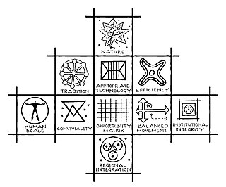
Principles of Intelligent Urbanism (PIU) is a theory of urban planning composed of a set of ten axioms intended to guide the formulation of city plans and urban designs. They are intended to reconcile and integrate diverse urban planning and management concerns. These axioms include environmental sustainability, heritage conservation, appropriate technology, infrastructure-efficiency, placemaking, social access, transit-oriented development, regional integration, human scale, and institutional integrity. The term was coined by Prof. Christopher Charles Benninger.
In human geography, a catchment area is the area from which a location, such as a city, service or institution, attracts a population that uses its services and economic opportunities. Catchment areas may be defined based on from where people are naturally drawn to a location or as established by governments or organizations for the provision of services.
A settlement hierarchy is a way of arranging settlements into a hierarchy based upon their size. The term is used by landscape historians and in the National Curriculum for England. The term is also used in the planning system for the UK and for some other countries such as Ireland, India, and Switzerland. The term was used without comment by the geographer Brian Roberts in 1972.
The following outline is provided as an overview of and topical guide to geography:
Unified settlement planning (USP) is the component of regional planning where a unified approach is applied for a region's overall development. The USP approach is most often associated with urban planning practices in India.
Economy is conventionally defined as a function for production and distribution of goods and services by multiple agents within a society and/or geographical place An economy is hierarchical, made up of individuals that aggregate to make larger organizations such as governments and gives value to goods and services. The Maya economy had no universal form of trade exchange other than resources and services that could be provided among groups such as cacao beans and copper bells. Though there is limited archeological evidence to study the trade of perishable goods, it is noteworthy to explore the trade networks of artifacts and other luxury items that were likely transported together.
References
Openshaw S, Veneris Y, 2003, "Numerical experiments with central place theory and spatial interaction modelling" Environment and Planning A 35(8) 1389–1403 ()
Smith, Margot W. Physician's Specialties and Medical Trade Areas: An Application of Central Place Theory. Papers and Proceedings of Applied Geography Conferences, Vol. 9, West Point NY 1986.
Smith, Margot W. A Guide to the Delineation of Medical Care Regions, Medical Trade Areas and Hospital Service Areas. Public Health Reports, 94:3:247 May 1979
Smith, Margot W. The Economics of Physician Location, Western Regional Conference, American Association of Geographers, Chicago, Illinois, 1979
Smith, Margot W. The Distribution of Medical Care in Central California: a Social and Economic Analysis, Thesis, School of Public Health, University of California, Berkeley, 1977 - 1004 pages
Veneris, Y, 1984, Informational Revolution, Cybernetics and Urban Modelling, PhD Thesis, University of Newcastle upon Tyne, UK.
This page is based on this Wikipedia article Text is available under the CC BY-SA 4.0 license; additional terms may apply. Images, videos and audio are available under their respective licenses.