Morocco is the northwesternmost country which spans from the Mediterranean Sea and Atlantic Ocean on the north and the west respectively, into large mountainous areas in the interior, to the Sahara desert in the far south. Morocco is a Northern African country, located in the extreme northwest of Africa on the edge of continental Europe. The Strait of Gibraltar separates Spain from Morocco with a 13 kilometres (8.1 mi) span of water. Morocco borders the North Atlantic Ocean to the west, and the western Mediterranean Sea to the north, and has borders with Algeria and disputed Western Sahara.

Slovakia is a landlocked Central European country with mountainous regions in the north and flat terrain in the south. During much of the Holocene, Slovakia was much more forested than today. Decline of the forest occurred in as consequence of the Valachian colonization and the development of mining in the territory.
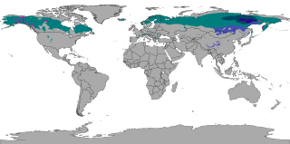
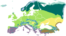
The subarctic climate is a continental climate with long, cold winters, and short, warm to cool summers. It is found on large landmasses, often away from the moderating effects of an ocean, generally at latitudes from 50°N to 70°N, poleward of the humid continental climates. Subarctic or boreal climates are the source regions for the cold air that affects temperate latitudes to the south in winter. These climates represent Köppen climate classification Dfc, Dwc, Dsc, Dfd, Dwd and Dsd.

In physical geography, a steppe is an ecoregion characterized by grassland plains without closed forests except near rivers and lakes. Steppe biomes may include:

Geographically, the country of Iran is located in West Asia and borders the Caspian Sea, Persian Gulf, and Gulf of Oman. Topographically, it is predominantly located on the Persian Plateau. Its mountains have impacted both the political and the economic history of the country for several centuries. The mountains enclose several broad basins, on which major agricultural and urban settlements are located. Until the 20th century, when major highways and railroads were constructed through the mountains to connect the population centers, these basins tended to be relatively isolated from one another.

The United Kingdom straddles the higher mid-latitudes between 49° and 61°N on the western seaboard of Europe. Since the UK is always in or close to the path of the polar front jet stream, frequent changes in pressure and unsettled weather are typical. Many types of weather can be experienced in a single day.

A Mediterranean climate, also called a dry summer climate, described by Köppen as Cs, is a temperate climate type that occurs in the lower mid-latitudes. Such climates typically have dry summers and wet winters, with summer conditions ranging from warm to hot and winter conditions typically being mild to cool. These weather conditions are typically experienced in the majority of Mediterranean-climate regions and countries, but remain highly dependent on proximity to the ocean, altitude and geographical location.

The subtropical zones or subtropics are geographical and climate zones to the north and south of the tropics. Geographically part of the temperate zones of both hemispheres, they cover the middle latitudes from 23°26′10.1″ (or 23.43615°) to approximately 35° north and south. The horse latitudes lie within this range.

A semi-arid climate, semi-desert climate, or steppe climate is a dry climate sub-type. It is located on regions that receive precipitation below potential evapotranspiration, but not as low as a desert climate. There are different kinds of semi-arid climates, depending on variables such as temperature, and they give rise to different biomes.

A humid continental climate is a climatic region defined by Russo-German climatologist Wladimir Köppen in 1900, typified by four distinct seasons and large seasonal temperature differences, with warm to hot summers, and cold and snowy winters. Precipitation is usually distributed throughout the year, but often these regions do have dry seasons. The definition of this climate in terms of temperature is as follows: the mean temperature of the coldest month must be below 0 °C (32.0 °F) or −3 °C (26.6 °F) depending on the isotherm, and there must be at least four months whose mean temperatures are at or above 10 °C (50 °F). In addition, the location in question must not be semi-arid or arid. The cooler Dfb, Dwb, and Dsb subtypes are also known as hemiboreal climates. Although amount of snowfall is not a factor used in defining the humid continental climate, snow during the winter in this type of climate is almost a guarantee, either intermittently throughout the winter months near the poleward or coastal margins, or persistently throughout the winter months elsewhere in the climate zone.
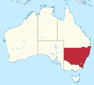
New South Wales is Australia's most populous state, located in the east coast of the continent. It is in the southern hemisphere between latitudes 28 and 38 degrees south of the equator and longitudes 141 and 154 degrees east of the Universal Prime Meridian. The state is in the warm temperate climatic zone.

Ardahan is a city in northeastern Turkey, near the Georgian border. It is the seat of Ardahan Province and Ardahan District. Its population is 22,927 (2021).

Doğubayazıt is a town of Ağrı Province of Turkey, near the border with Iran. Its elevation is 1625 m. It is the seat of Doğubayazıt District. Its population is 80,061 (2021). Also known as Kurdava, the town was the capital of the self-declared Republic of Ararat, an independent Kurdish state centered in the Ağrı Province.
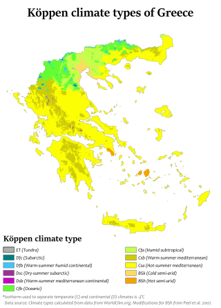
The climate in Greece is predominantly Mediterranean. However, due to the country's geography, Greece has a wide range of micro-climates and local variations. The Greek mainland is extremely mountainous, making Greece one of the most mountainous countries in Europe. To the west of the Pindus mountain range, the climate is generally wetter and has some maritime features. The east of the Pindus mountain range is generally drier and windier in summer. The highest peak is Mount Olympus, 2,918 metres (9,573 ft). The northern areas of Greece have a transitional climate between the continental, the Mediterranean and the humid subtropical climate. There are mountainous areas that have an alpine climate. Also, various areas of Greece have semi-arid climates.

The Eastern Anatolia Region is a geographical region of Turkey. The most populous province in the region is Van Province. Other populous provinces are Malatya, Erzurum and Elazığ.

The climate of the United States varies due to changes in latitude, and a range of geographic features, including mountains and deserts. Generally, on the mainland, the climate of the U.S. becomes warmer the further south one travels, and drier the further west, until one reaches the West Coast.

Pakistan's climate varies from a continental type of climate in the north, a mountainous dry climate in the west (Baluchistan), a wet climate in the East (Punjab) an arid climate in the Thar Desert, to a tropical climate in the southeast (Sindh), characterized by extreme variations in temperature, both seasonally and daily, because it is located on a great landmass barely north of the Tropic of Cancer.

Kosovo is a relatively small country. Because of the climatic position and complicated structure of the relief it has a variety of climate systems.

The south of Sweden has a temperate climate, despite its northern latitude, with largely four distinct seasons and mild temperatures throughout the year. The winter in the far south is usually weak and is manifested only through some shorter periods with snow and sub-zero temperatures, autumn may well turn into spring there, without a distinct period of winter. The northern parts of the country have a subarctic climate while the central parts have a humid continental climate. The coastal south can be defined as having either a humid continental climate using the 0 °C isotherm, or an oceanic climate using the –3 °C isotherm.

Cyprus has a subtropical climate - Mediterranean and semi-arid type - according to Köppen climate classification signes Csa and BSh, with very mild winters and warm to hot summers. Snow is possible only in the Troodos mountains in the central part of the island. Rain occurs mainly in winter, with summer being generally dry.