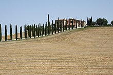
The climate of Italy is highly diverse. In most of the inland northern and central regions, the climate ranges from humid subtropical to humid continental and oceanic. The climate of the Po valley geographical region is mostly humid subtropical, with cool winters and hot summers.[1][2] The coastal areas of Liguria, Tuscany and most of the South experience a Mediterranean climate according to the Köppen climate classification.
Between the north and south there can be a considerable difference in temperature, above all during the winter: on some winter days it can be −2°C (28°F) and snowing in Milan, while it is 8°C (46.4°F) in Rome and 20°C (68°F) in Palermo. Temperature differences are less extreme in the summer. On 11 August 2021, an agricultural monitoring station near Syracuse recorded 48.8°C (119.8°F) which constitutes the official record of the highest temperature in Europe according to the World Meteorological Organization.[3]
The Italian climate is influenced by the large body of water of the Mediterranean Seas that surrounds Italy on every side except the north. These seas constitute a reservoir of heat and humidity for Italy. Within the southern temperate zone, they determine a Mediterranean climate with local differences due to the geomorphology of the territory, which tends to make its mitigating effects felt, especially in high pressure conditions.[4]
In addition to Mediterranean influences, the Italian climate is partly affected by the western currents, especially in the intermediate seasons, also by the dynamics in the Atlantic Ocean, with its cyclones that travel from west to east, driven by the zonal circulation and more generally by the reciprocal position, on a synoptic level, of the Azores anticyclone and the African subtropical anticyclone[it].[5] The cold winter airs, are in part influenced by the mountain ranges of the Alps and the Apennines.[6] The mitigating effect of the Mediterranean is added to this condition with a tendency to reinvigorate, due to the transfer of sensible heat and humidity, the weakened perturbations from the west or with the formation of Mediterranean Low[it] or Mediterranean cyclogenesis.[7]
Italy is part of the Northern Hemisphere. The country's total area is 301,230 square kilometres (116,306sqmi), of which 294,020km2 (113,522sqmi) is land and 7,210km2 (2,784sqmi) is water.[12] Including islands, Italy has a coastline of 7,900km (4,900mi) on the Adriatic Sea, Ionian Sea, Tyrrhenian Sea, Ligurian Sea, Sea of Sardinia and Strait of Sicily, and borders shared with France (488km (303mi)), Austria (430km (267mi)), Slovenia (232km (144mi)) and Switzerland (740km (460mi)). San Marino (39km (24mi)) and Vatican City (3.2km (2.0mi)), both enclaves, account for the remainder.[12]
Over 35% of the Italian territory is mountainous.[13] The Apennine Mountains form the peninsula's backbone, and the Alps form most of its northern boundary, where Italy's highest point is located on Mont Blanc summit (Monte Bianco) (4,810m or 15,780ft). Other worldwide-known mountains in Italy include the Matterhorn (Monte Cervino), Monte Rosa, Gran Paradiso in the West Alps, and Bernina, Stelvio and Dolomites along the eastern side. The Po, Italy's longest river (652 kilometres or 405 miles), flows from the Alps on the western border with France and crosses the Po Valley on its way to the Adriatic Sea. The Po Valley is the largest plain in Italy, with 46,000km2 (18,000sqmi), and it represents over 70% of the total plain area in the country.[13]
Description
Conditions on the coast are different from those in the interior, particularly during winter months when the higher altitudes tend to be cold, wet, and often snowy. The coastal regions have mild winters and warm and generally dry summers, although lowland valleys can be quite hot in summer. Average winter temperatures vary from 0°C (32°F) on the Alps to 12°C (54°F) in Sicily, so average summer temperatures range from 20°C (68°F) to over 25°C (77°F). Winters can vary widely across the country with lingering cold, foggy and snowy periods in the north and milder, sunnier conditions in the south. Summers can be hot and humid across the country, particularly in the south while northern and central areas can experience occasional strong thunderstorms from spring to autumn.[14]
The east coast of the Italian peninsula is not as wet as the west coast, but is usually colder in the winter. The east coast north of Pescara is occasionally affected by the cold bora winds in winter and spring, but the wind is less strong here than around Trieste. During these frosty spells from E–NE cities like Rimini, Ancona, Pescara and the entire eastern hillside of the Apennines can be affected by true "blizzards". The town of Fabriano, located just around 300m (984ft) in elevation, can often see 50–60cm (20–24in) of fresh snow fall in 24 hours during these episodes.
On the coast from Ravenna to Venice and Trieste, snow falls more rarely: during cold spells from the east, the cold wind can be harsh but with bright skies. During the snowfalls that affect Northern Italy, the Adriatic coast can see a milder Sirocco wind which makes snow turn to rain. The mild effects of this wind often disappear just a few kilometres inside the plain, and sometimes the coast from Venice to Jesolo sees snow while it is raining in Trieste and surroundings, the Po River mouths and Ravenna. Rarely, the city of Trieste has seen snow blizzards with north-eastern winds. In the colder winters, the Venice Lagoon may freeze, and in the coldest ones even enough to walk on the ice sheet (December 1788).[15] Further south, snow may occur inland but it rarely happens at sea level, though snow at sea level has been recorded as far south as Sicily. Winters are generally milder in the coastal areas of the south, Sicily and Sardinia.
Summer is usually more stable, although the northern regions often have thunderstorms in the afternoon/night hours and some grey and rainy days. So, while south of Florence the summer is typically dry and sunny, in the north it tends to be more humid and cloudy. The humidity can make the northern plains particularly uncomfortable.
Spring and autumn weather can be very changeable, with sunny and warm weeks (sometimes with summer-like temperatures) suddenly broken off by cold spells or followed by rainy and cloudy weeks.
Sunshine duration, solar irradiance and cloud cover
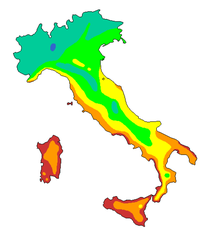
Based on the maps on sunshine duration[16][17] and on global solar irradiance[18] in Italy, the areas with the highest values are the coasts of Sardinia, the western and southern coastal strip of Sicily, the whole of Apulia south of Bari, and the coastal strips of the southern Tuscan Archipelago. All these areas have values of more than 2,600 hours of sunshine per year, with an average of more than seven hours per day.
On average, the northern and eastern coastal strip of Sicily, the innermost areas of Sardinia, the entire western peninsular coast to the south of Livorno, including the flat and hilly areas of the hinterland, the Ionian coast between Calabria and Basilicata, the inland areas of Lucania, the Adriatic coasts of Molise and the whole of northern Apulia, receive between 2,400 and 2,600 hours of sunshine per year (between 6.5 and seven hours per day).
Values between 2,200 and 2,400 hours of sunshine per year (between 6 and 6.5 hours per day) are recorded in the innermost areas of Sicily, in some sections of the Calabrian Ionian coast and in the corresponding inland areas, along the Adriatic coast of Abruzzo, in Liguria, Versilia, inland areas of northern and eastern Tuscany, in Umbria and in the hinterland of southern Lazio and Campania. All the other areas north of the imaginary oblique transversal line, drawn between the area immediately north of the city of Genoa and the border between Marche and Abruzzo, record annual average values that do not reach 2,200 hours, or less than six hours per day.
The highest annual average values in the network of pyranometric stations relating to global solar irradiance are higher than 18MJ/m2 (0.46kWh/sqft) and concern the southern and south-eastern extremities of Sicily. Average annual values between 16MJ/m2 (0.41kWh/sqft) and 18MJ/m2 (0.46kWh/sqft) are recorded over a large part of the Aosta Valley, on the western alpine extremity of Piedmont, on the island of Pianosa, on the coastal and sublittoral areas of the middle and southern Lazio, in the south-central Apulia, Calabria, Sardinia and most of Sicily (including the islands of Ustica, Pantelleria and Lampedusa).
Average annual values between 14MJ/m2 (0.36kWh/sqft) and 16MJ/m2 (0.41kWh/sqft) affect western Liguria, a large part of Tuscany and central-northern Lazio, a large part of the Marche, Abruzzo and Molise, Campania, Basilicata, northern Puglia and north-eastern Sardinia. Average annual values between 12MJ/m2 (0.31kWh/sqft) and 14MJ/m2 (0.36kWh/sqft) occur in central-eastern Piedmont, eastern Liguria, Lombardy, Trentino-Alto Adige, Veneto, Friuli-Venezia Giulia, most of Emilia-Romagna and on the Apennine ridge between Emilia, Tuscany, Umbria, Marche and Lazio. Average annual values of less than 12MJ/m2 (0.31kWh/sqft) are recorded in an area of the Tuscan-Emilian Apennines which includes the highest peaks.
Cloud cover generally tends to reach the lowest average values in the month of July, while the highest average values, according to the different climatic zones, can affect several months between late autumn and the first part of spring, with the highest average values in most of the territory recorded in November.[19]
Fog in Po Valley is frequent during the winter time
In the south, summer marks a distinct dry season, characteristic of Mediterranean climates. This includes cities such as Naples, Rome, Bari, and Palermo. In the north, precipitation is more evenly distributed during the year, although the summer is usually slightly wetter. Between November and March the Po valley is often covered by fog, especially in the central zone (Pavia, Piacenza, Cremona and Mantua), while the number of days with lows below 0°C (32°F) is usually from 60 to 90 a year, with peaks of 100–110 days in the mainly rural zones.[20]
Snow is quite common between early December and early March in cities like Turin, Milan and Bologna, but sometimes it appears in late November or late March and even April. In the winter of 2005–2006, Milan received around 0.75–0.8m (2ft 5.53in– 2ft 7.50in) or 75–80cm (29.5–31.5in) of fresh snow, Como around 1m (3ft 3.37in) or 100cm (39.4in), Brescia0.5m (1ft 7.69in) or 50cm (19.7in), Trento1.6m (5ft 2.99in) or 160cm (63.0in), Vicenza around 0.45m (1ft 5.72in) or 45cm (17.7in), Bologna around 0.3m (11.81in) or 30cm (11.8in), and Piacenza around 0.8m (2ft 7.50in) or 80cm (31.5in)[21]
Often, the largest snowfalls happen in February, sometime in January or March. In the Alps, snow falls more in autumn and spring over 1,500m (4,921ft), because winter is usually marked by cold and dry periods; while the Apennines see many more snow falls during winter, but they are warmer and less wet in the other seasons.
Both mountain chains can see up to 5–10m (16ft 4.85in– 32ft 9.70in) or 500–1,000cm (196.9–393.7in) of snow in a year at 2,000m (6,562ft). On the highest peaks of the Alps, snow may fall even during mid summer, and glaciers are present.
Summer temperatures are often similar north to south. July temperatures are 22–24°C (71.6–75.2°F) north of river Po, like in Milan or Venice, and south of river Po can reach 24–25°C (75.2–77.0°F) like in Bologna, with fewer thunderstorms; on the coasts of Central and Southern Italy, and in the near plains, mean temperatures goes from 23°C to 27°C (80.6°F). Generally, the hottest month is August in the south and July in the north; during these months the thermometer can reach 38–42°C (100.4–107.6°F) in the south and 32–35°C (89.6–95.0°F) in the north; Sometimes the country can be split as during winter, with rain and 20–22°C (68.0–71.6°F) during the day in the north, and 30–40°C (86–104°F) in the south; but, having a hot and dry summer does not mean that Southern Italy will not see rain from June to August. Thunderstorms, while much more common in the humid north, occasionally also occur in the south. High humidity may keep nighttime temperatures high in Italy's cities during the summer months.
The coldest month is January: the Po valley's mean temperature is between −1–1°C (30.2–33.8°F), Venice 2–3°C (35.6–37.4°F), Trieste 6–7°C (42.8–44.6°F), Florence 5–6°C (41.0–42.8°F), Rome 7–8°C (44.6–46.4°F), Naples9°C (48.2°F), and Cagliari12°C (53.6°F). Winter morning lows can occasionally reach −30 to −20°C (−22.0 to −4.0°F) in the Alps, −14 to −8°C (6.8 to 17.6°F) in the Po valley, −7°C (19.4°F) in Florence, −4°C (24.8°F) in Rome, −2°C (28.4°F) in Naples and 2°C (35.6°F) in Palermo. In cities like Rome and Milan, strong heat islands can exist, so that inside the urban area, winters can be milder and summers more sultry.
On some winter mornings it can be just −3°C (26.6°F) in Milan's Piazza del Duomo while −8 to −9°C (17.6 to 15.8°F) in the metropolitan outskirts, in Turin can be just −5°C (23.0°F) in the city centre and −10 to −12°C (14.0 to 10.4°F) in the metropolitan outskirts.
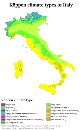
It is found in all the coastal areas, excluding the north-eastern area and the area of Liguria from Genoa to Savona, which have a Humid subtropical climate. The winter average varies from 6°C (42.8°F), in the northern areas, to 11–14°C (51.8–57.2°F) in the southern islands. During the summer, averages are near 23°C (73.4°F) in the north (Liguria) and sometimes reach 26–28°C (78.8–82.4°F) in the south. Precipitation mostly occurs during the winter. Snowfalls are rare and usually very light in the north, and almost never happen in the south. Summers are dry and hot.
A relatively "continental" and "four-season" version of the humid subtropical climate can be found in the Po and Adige valleys in the North, and sometimes in low inland Central and Southern Italy. It is marked by hot and wet summers, while winters are moderately cold. The precipitation is higher and there is no dry season. Average temperatures are around 1°C to 3°C in January, and more than 22°C in July and August.
Climate data for Linate Airport, Milan (1991–2020 normals, sun 1981-2010, extremes 1946–present)
Source 2: Istituto Superiore per la Protezione e la Ricerca Ambientale[31]
Transition between Cfa and Csa climates
Some parts of Italy have a climate which cannot be precisely defined as either Cfa or Csa, presenting elements from both. This zone can be found both in some lake and hill resorts of Northern Italy (usually with wetter summers) and in some area like inner Tuscany (usually with drier summers). Florence is a good example of this transition climate:
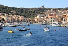
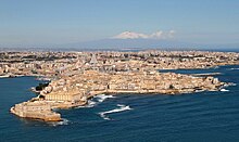
Syracuse, Sicily, where the highest temperature ever in Europe was recorded, 48.8°C (119.8°F)
The record low temperature in Italy is −49.6°C (−57.3°F), recorded on 10 February 2013 in the Alps on the Pale di San Martino plateau, in Trentino-Alto Adige,[35] while near sea level is −24.8°C (−12.6°F), recorded on 12 January 1985 at San Pietro Capofiume, frazione of Molinella, in Emilia-Romagna.[36] The lowest temperature record for an inhabited place is −37.4°C (−35.3°F), recorded on 15 February 2012 in Rocca di Mezzo, Abruzzo, in the Apennines.[37]
The maximum snow depth was recorded in March 1951 in the Alps at the meteorological station of Lake D'Avino, in Piedmont, with a value of 1,125cm (443in).[38] The maximum snowfall in 24 hours is 181cm (71in), recorded in the Apennines in the village of Roccacaramanico, frazione of Sant'Eufemia a Maiella (Majella massif), Abruzzo, on 15 January 1951.[39]
The village of Musi, frazione of the municipality of Lusevera, Friuli-Venezia Giulia, with an annual average precipitation of 3,313mm (130.4in) (with a record of 5,406mm (212.8in) in 2014) is the wettest place in Italy.[40] The maximum rainfall in 24 hours was recorded in Bolzaneto, a quarter of Genoa, Liguria, on 10 September 1970 with a value of 948mm (37.3in).[41] However, there are many daily rainfall records around Italy exceeding 500mm (20in).[42][43]
In the south, Sicily has experienced highs of 46°C (114.8°F) in some hot summers.[44] On 25 June 2007 47.0°C (116.6°F) were recorded in Foggia, Apulia, and on 10 August 1999, 48.5°C (119.3°F) were recorded in Catenanuova in Sicily.[45][46] The latter is not official, and generally considered dubious. On 11 August 2021, an agricultural monitoring station near Syracuse, Sicily recorded 48.8°C (119.8°F) which constitutes the official record of the highest temperature in Europe according to the World Meteorological Organization.[3]
Italy, like other parts of the globe, has been subject in the past to climate changes on a planetary scale (for example glaciations and interglacial periods, Little Ice Age). Contemporary climate change (global warming) has also had numerous effects on Italy. In particular, compared to the 1960s and 1970s, from the mid-1980s onwards there was a recorded increase in the average temperature.[47][48]
The geography of Italy includes the description of all the physical geographical elements of Italy. Italy, whose territory largely coincides with the homonymous geographical region, is located in southern Europe and comprises the long, boot-shaped Italian Peninsula crossed by the Apennines, the southern side of Alps, the large plain of the Po Valley and some islands including Sicily and Sardinia. Italy is part of the Northern Hemisphere. Two of the Pelagie Islands are located on the African continent.
Slovakia is a landlocked Central European country with mountainous regions in the north and flat terrain in the south. During much of the Holocene, Slovakia was much more forested than today. Decline of the forest occurred in as consequence of the Valachian colonization and the development of mining in the territory.
The geography of Switzerland features a mountainous and landlocked country located in Western and Central Europe. Switzerland's natural landscape is marked by its numerous lakes and mountains. It is surrounded by five countries: Austria and Liechtenstein to the east, France to the west, Italy to the south and Germany to the north. Switzerland has a maximum north–south length of 220 kilometres (140 mi) and an east–west length of about 350 kilometres (220 mi).
The subarctic climate is a continental climate with long, cold winters, and short, warm to cool summers. It is found on large landmasses, often away from the moderating effects of an ocean, generally at latitudes from 50°N to 70°N, poleward of the humid continental climates. Subarctic or boreal climates are the source regions for the cold air that affects temperate latitudes to the south in winter. These climates represent Köppen climate classification Dfc, Dwc, Dsc, Dfd, Dwd and Dsd.
The Alpine region of Switzerland, conventionally referred to as the Swiss Alps, represents a major natural feature of the country and is, along with the Swiss Plateau and the Swiss portion of the Jura Mountains, one of its three main physiographic regions. The Swiss Alps extend over both the Western Alps and the Eastern Alps, encompassing an area sometimes called Central Alps. While the northern ranges from the Bernese Alps to the Appenzell Alps are entirely in Switzerland, the southern ranges from the Mont Blanc massif to the Bernina massif are shared with other countries such as France, Italy, Austria and Liechtenstein.
The United Kingdom straddles the higher mid-latitudes between 49° and 61°N on the western seaboard of Europe. Since the UK is always in or close to the path of the polar front jet stream, frequent changes in pressure and unsettled weather are typical. Many types of weather can be experienced in a single day.
The Apennines or Apennine Mountains are a mountain range consisting of parallel smaller chains extending c. 1,200 km (750 mi) along the length of peninsular Italy. In the northwest they join with the Ligurian Alps at Altare. In the southwest they end at Reggio di Calabria, the coastal city at the tip of the peninsula. Since 2000 the Environment Ministry of Italy, following the recommendations of the Apennines Park of Europe Project, has been defining the Apennines System to include the mountains of north Sicily, for a total distance of 1,500 kilometres (930 mi). The system forms an arc enclosing the east side of the Ligurian and Tyrrhenian seas.
The province of Parma is a province in the Emilia-Romagna region of Italy. Its largest town and capital is the city of Parma.
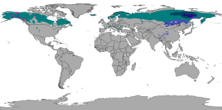
A humid continental climate is a climatic region defined by Russo-German climatologist Wladimir Köppen in 1900, typified by four distinct seasons and large seasonal temperature differences, with warm to hot summers, and cold and snowy winters. Precipitation is usually distributed throughout the year, but often these regions do have dry seasons. The definition of this climate in terms of temperature is as follows: the mean temperature of the coldest month must be below 0 °C (32.0 °F) or −3 °C (26.6 °F) depending on the isotherm, and there must be at least four months whose mean temperatures are at or above 10 °C (50 °F). In addition, the location in question must not be semi-arid or arid. The cooler Dfb, Dwb, and Dsb subtypes are also known as hemiboreal climates. Although amount of snowfall is not a factor used in defining the humid continental climate, snow during the winter in this type of climate is almost a guarantee, either intermittently throughout the winter months near the poleward or coastal margins, or persistently throughout the winter months elsewhere in the climate zone.
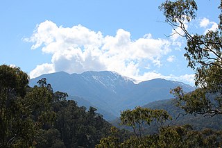
Mount Hotham is a mountain located in the Victorian Alps of the Great Dividing Range, in the Australian state of Victoria. The mountain is located approximately 357 kilometres (222 mi) north east of Melbourne, 746 kilometres (464 mi) from Sydney, and 997 kilometres (620 mi) from Adelaide by road. The nearest major road to the mountain is the Great Alpine Road. The mountain is named after Charles Hotham, Governor of Victoria from 1854 to 1855.
The province of Belluno is a province in the Veneto region of Italy. Its capital is the city of Belluno.
Northern Italy is a geographical and cultural region in the northern part of Italy. The Italian National Institute of Statistics defines the region as encompassing the four northwestern regions of Piedmont, Aosta Valley, Liguria and Lombardy in addition to the four northeastern regions of Trentino-Alto Adige, Veneto, Friuli-Venezia Giulia and Emilia-Romagna.
Mount Buller is a mountain in the Victorian Alps of the Great Dividing Range, located in the Australian state of Victoria. It has an elevation of 1,805 metres (5,922 ft) AHD.
Ovada is a comune (municipality) of 11,484 inhabitants in the Province of Alessandria in the northern Italian region Piedmont, located about 90 kilometres (56 mi) southeast of Turin and about 30 kilometres (19 mi) south of Alessandria.
The Po Valley, Po Plain, Plain of the Po, or Padan Plain is a major geographical feature of Northern Italy. It extends approximately 650 km (400 mi) in an east-west direction, with an area of 46,000 km2 including its Venetic extension not actually related to the Po river basin; it runs from the Western Alps to the Adriatic Sea. The flatlands of Veneto and Friuli are often considered apart since they do not drain into the Po, but they effectively combine into an unbroken plain, making it the largest in Southern Europe. It has a population of 17 million, or a third of Italy's total population.
Australia's climate is governed mostly by its size and by the hot, sinking air of the subtropical high pressure belt. This moves north-west and north-east with the seasons. The climate is variable, with frequent droughts lasting several seasons, thought to be caused in part by the El Niño-Southern Oscillation. Australia has a wide variety of climates due to its large geographical size. The largest part of Australia is desert or semi-arid. Only the south-east and south-west corners have a temperate climate and moderately fertile soil. The northern part of the country has a tropical climate, varying between grasslands and desert. Australia holds many heat-related records: the continent has the hottest extended region year-round, the areas with the hottest summer climate, and the highest sunshine duration.
The climate of Hungary is characterized by its position. Hungary is in the eastern part of Central Europe, roughly equidistant from the Equator and the North Pole, more than 1,000 kilometres (600 mi) from both and about 1,000 kilometres from the Atlantic Ocean.
The flora of Italy is all the plant life present in the territory of the Italian Republic. The flora of Italy was traditionally estimated to comprise about 5,500 vascular plant species. However, as of 2019, 7,672 species are recorded in the second edition of the flora of Italy and in its digital archives Digital flora of Italy. In particular, 7,031 are autochthonous and 641 are non native species widely naturalized since more than three decades. Additionally, further 468 exotic species have been recorded as adventitious or naturalized in more recent times.
Victoria is the southernmost mainland state of Australia. With an area of 227,444 km2 (87,817 sq mi), it is Australia's sixth largest state/territory, comparable in size to the island of Great Britain or the U.S. state of Utah. It is bound to the northwest by South Australia, directly north by New South Wales, and also shares a maritime border with Tasmania across the Bass Strait to the south. Most of Victoria's northern border lies along the Murray River. The eastern half of the state is dominated by the Australian Alps and the surrounding highlands of the Great Dividing Range, which also to a lesser extent extend far into the west of the state and ease off after The Grampians. By comparison the north and northwest of the state is extremely flat with little prominence.
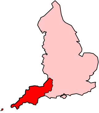
The climate of south-west England is classed as oceanic (Cfb) according to the Köppen climate classification. The oceanic climate is typified by frequent cloudy skies, cool winters with cool summers and precipitation all year round, with more experienced in winter. Annual rainfall is about 1,000 millimetres (39 in) and up to 2,000 millimetres (79 in) on higher ground. Exceptions include areas to the east of high ground ( e.g. Exeter / parts of West Somerset that are subject to a rain shadow effect and annual rainfall is closer to 30 inches.
References
↑ Adriana Rigutti, Meteorologia, Giunti, p. 95, 2009.
↑ Thomas A. Blair, Climatology: General and Regional, Prentice Hall pp. 131–132
1 2 Riganti, dir. da Alberto (1991). Enciclopedia universale Garzanti (Nuova ed. aggiornata e ampliata.ed.). Milano: Garzanti. ISBN88-11-50459-7.
↑ "Climate Atlas of Italy". Network of the Air Force Meteorological Service. Archived from the original on 14 November 2012. Retrieved 30 September 2012.
↑ Atlante Geografico Metodico De Agostini, 2002, Novara, Istituto Geografico De Agostini, p. 85.
↑ M. Pinna, L'eliofania in Italia, Roma, 1985, (Memorie della Società Geografica Italiana, 39), pp. 23-58.
↑ Lavagnini A., Martorelli S., Coretti C. (1987). Radiazione solare in Italia. Mappe mensili della radiazione globale giornaliera. Roma, CNR, Ist. Fis. Atm.
This page is based on this Wikipedia article Text is available under the CC BY-SA 4.0 license; additional terms may apply. Images, videos and audio are available under their respective licenses.