Darmstadt, Indiana

Last updated

Darmstadt, Indiana
Darmstadt, Indiana.jpg
Vanderburgh County Indiana Incorporated and Unincorporated areas Darmstadt Highlighted 1816858.svg
Location of Darmstadt in Vanderburgh County, Indiana.
Coordinates: 38°5′28″N87°34′34″W / 38.09111°N 87.57611°W / 38.09111; -87.57611
Country United States
State Indiana
County Vanderburgh
Township Scott, Armstrong, Center, German
Named for Darmstadt, Germany
Government
  Type Town Council
Area
[1]
  Total4.58 sq mi (11.85 km2)
  Land4.52 sq mi (11.70 km2)
  Water0.06 sq mi (0.15 km2)
Elevation
[2]
479 ft (146 m)
Population
 (2020)
  Total1,373
  Density304.03/sq mi (117.38/km2)
Time zone UTC-6 (CST)
  Summer (DST) UTC-5 (CDT)
ZIP codes
47720, 47725, 47710, 47618
Area code 812
FIPS code 18-16858 [3]
GNIS feature ID2396680 [2]
Website http://www.darmstadt-indiana.org
Addresses in Darmstadt are referred to as Darmstadt, IN there is an Inglefield, Indiana 47618 post office in Darmstadt that also has the Darmstadt, IN address

Darmstadt is a small, German-heritage town primarily located in Scott Township, Vanderburgh County, Indiana, United States. [2] It also extends slightly into Armstrong, Center and German townships. The population was 1,407 at the 2010 census. Darmstadt, located just north of Evansville, is the only other incorporated municipality in Vanderburgh County besides Evansville.

Contents

Geography

Darmstadt is located at 38°5′28″N87°34′34″W / 38.09111°N 87.57611°W / 38.09111; -87.57611 (38.091041, -87.576207). [4]

According to the 2010 census, Darmstadt has a total area of 4.58 square miles (11.86 km2), of which 4.52 square miles (11.71 km2) (or 98.69%) is land and 0.06 square miles (0.16 km2) (or 1.31%) is water. [5]

The Village Market in Darmstadt The Village Market in Darmstadt, Indiana.jpg
The Village Market in Darmstadt

Demographics

Historical population
CensusPop.Note
1880 150
1980 1,280
1990 1,3465.2%
2000 1,313−2.5%
2010 1,4077.2%
2020 1,373−2.4%
U.S. Decennial Census [6]

2010 census

As of the census [7] of 2010, there were 1,407 people, 544 households, and 441 families living in the town. The population density was 311.3 inhabitants per square mile (120.2/km2). There were 564 housing units at an average density of 124.8 per square mile (48.2/km2). The racial makeup of the town was 97.5% White, 0.6% African American, 0.8% Asian, 0.1% Pacific Islander, 0.3% from other races, and 0.8% from two or more races. Hispanic or Latino of any race were 0.6% of the population.

There were 544 households, of which 30.1% had children under the age of 18 living with them, 72.2% were married couples living together, 5.5% had a female householder with no husband present, 3.3% had a male householder with no wife present, and 18.9% were non-families. 15.6% of all households were made up of individuals, and 7.5% had someone living alone who was 65 years of age or older. The average household size was 2.59 and the average family size was 2.88.

The median age in the town was 47.1 years. 21.3% of residents were under the age of 18; 6.1% were between the ages of 18 and 24; 18.8% were from 25 to 44; 36.6% were from 45 to 64; and 17% were 65 years of age or older. The gender makeup of the town was 51.5% male and 48.5% female.

2000 census

As of the census [3] of 2000, there were 1,313 people, 490 households, and 605 families living in the town. The population density was 262.1 inhabitants per square mile (101.2/km2). There were 503 housing units at an average density of 106.6 per square mile (41.2/km2). The racial makeup of the town was 99.16% White, 0.23% African American, 0.15% Asian, and 0.46% from two or more races. Hispanic or Latino of any race were 0.08% of the population.

There were 490 households, out of which 34.3% had children under the age of 18 living with them, 76.3% were married couples living together, 4.3% had a female householder with no husband present, and 17.3% were non-families. 15.3% of all households were made up of individuals, and 9.4% had someone living alone who was 65 years of age or older. The average household size was 2.68 and the average family size was 2.97.

In the town, the population was spread out, with 25.5% under the age of 18, 5.3% from 18 to 24, 24.7% from 25 to 44, 29.0% from 45 to 64, and 15.5% who were 65 years of age or older. The median age was 43 years. For every 100 females, there were 98.3 males. For every 100 females age 18 and over, there were 98.4 males.

The median income for a household in the town was $68,359, and the median income for a family was $72,813. Males had a median income of $50,605 versus $28,750 for females. The per capita income for the town was $31,898. About 0.5% of families and 1.1% of the population were below the poverty line, including none of those under age 18 and 1.0% of those age 65 or over.

Transportation

Darmstadt is served by a number of different transportation methods. The major roads in Darmstadt include Darmstadt Road, Saint Joseph Avenue, and Boonville-New Harmony Road. Darmstadt Road and Saint Joseph Avenue provide direct access to Evansville, and Boonville-New Harmony Road runs directly by the shopping center, providing links to both Boonville and New Harmony.

U.S. 41 runs north-to-south directly east of Darmstadt, providing yet another access point to Evansville, as well as quick access to I-64.

See also

World Peace Tree, a historically significant tree in Darmstadt

Related Research Articles

<span class="mw-page-title-main">Warrick County, Indiana</span> County in Indiana, United States

Warrick County is a county located in the U.S. state of Indiana. As of 2020, the population was 63,898. The county seat is Boonville. It was organized in 1813 and was named for Captain Jacob Warrick, an Indiana militia company commander killed in the Battle of Tippecanoe in 1811. It is one of the ten fastest-growing counties in Indiana.

<span class="mw-page-title-main">Vanderburgh County, Indiana</span> County in Indiana, United States

Vanderburgh County is a county in the U.S. state of Indiana. As of 2020, the population was 180,136. The county seat is in Evansville. While Vanderburgh County was the eighth-largest county in 2020 population in Indiana, it is also the eighth-smallest county in area and the smallest in southwestern Indiana, covering only 236 square miles (610 km2).

<span class="mw-page-title-main">Evansville, Illinois</span> Village in Illinois, United States

Evansville is a village in Randolph County, Illinois, United States, on the banks of the Kaskaskia River. The population was 547 at the 2020 census.

<span class="mw-page-title-main">Fort Branch, Indiana</span> Town in Indiana, United States

Fort Branch is the largest town and 2nd largest community in Gibson County, Indiana after Princeton. The population was 2,965 at the 2020 census. It is part of the Evansville, Indiana, Metropolitan Area.

<span class="mw-page-title-main">Haubstadt, Indiana</span> Town in Indiana, United States

Haubstadt is the second largest town, after Fort Branch, and fourth largest community in Gibson County, Indiana, United States. The population was 1,638 at the 2020 census. Haubstadt has recently become a bedroom community of Evansville and such, is part of the Evansville, Indiana, Metropolitan Area.

<span class="mw-page-title-main">Boonville, Indiana</span> City in Indiana, United States

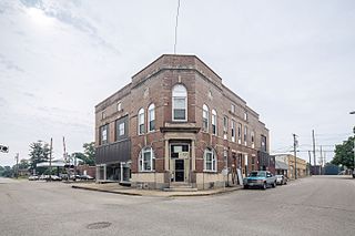
Boonville is a city in Boon Township, Warrick County, Indiana, United States. The population was 6,246 at the 2010 census. The city is the county seat of Warrick County.

<span class="mw-page-title-main">Chandler, Indiana</span> Town in Indiana, United States

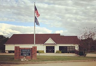
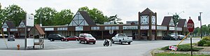
Chandler is a town straddling Ohio and Boon Township in Warrick County, Indiana, United States, located just east of Evansville, Indiana along the Ohio River. The population was 3,693 at the 2020 census, making it Warrick County's second-most populous municipality after Boonville. The town is part of the Evansville metropolitan area with a population of 342,815.

<span class="mw-page-title-main">Elberfeld, Indiana</span> Town in Indiana, United States

Elberfeld is a town in Greer Township, Warrick County, in the U.S. state of Indiana. The population was 625 as of the 2010 census.

<span class="mw-page-title-main">Lynnville, Indiana</span> Town in Indiana, United States

Lynnville is a town in Hart Township, Warrick County, in the U.S. state of Indiana. The population was 888 at the 2010 census.

<span class="mw-page-title-main">Tennyson, Indiana</span> Town in Indiana, United States

Tennyson is a town in Skelton Township, Warrick County, in the U.S. state of Indiana. The population was 279 at the 2010 census.

Whipps Millgate is a former city in Jefferson County, Kentucky, United States. The population was 415 at the 2000 census. The City of Whipps Millgate was incorporated on April 26, 1969, it was dissolved and annexed by the City of Lyndon, Kentucky on July 1, 2001.

<span class="mw-page-title-main">Lecompte, Louisiana</span> Town in Louisiana, United States

Lecompte is a town in Rapides Parish, Louisiana, United States. Lecompte is situated along the banks of Bayou Boeuf in central Louisiana. US Highway 71, Louisiana’s major north-south route which connects Baton Rouge and Shreveport, runs through Lecompte. Lecompte is named after the famous race horse called LeComte, which was named after horse breeder Ambrose LeComte. It is part of the Alexandria, Louisiana metropolitan area. The population was 1,227 at the 2010 and had dropped to 845 at the 2020 Census.

<span class="mw-page-title-main">Evansville, Minnesota</span> City in Minnesota, United States

Evansville is a city in Douglas County, Minnesota, United States. The population was 603 at the 2020 census.

<span class="mw-page-title-main">Prairie Home, Missouri</span> City in Missouri, United States

Prairie Home is a city, in Cooper County, Missouri, United States. The population was 280 at the 2010 census.

Lyons Falls is a village in Lewis County, New York, United States. The population was 566 at the 2010 census. The village is on the border of the towns of West Turin and Lyonsdale. It is at the junction of state Routes 12 and 12D, approximately 14 miles (23 km) south of Lowville, the county seat.

<span class="mw-page-title-main">Boonville, North Carolina</span> Town in North Carolina, United States

Boonville is a town in Yadkin County, North Carolina, United States. The population was 1,222 at the 2010 census.

<span class="mw-page-title-main">Evansville, Wyoming</span> Town in Wyoming, United States

Evansville is a town in Natrona County, Wyoming, United States. It is part of the Casper, Wyoming Metropolitan Statistical Area. The population was 2,544 at the 2010 census.

<span class="mw-page-title-main">Van Tassell, Wyoming</span> Town in Wyoming, United States

Van Tassell is a town in Niobrara County, Wyoming, United States. The population was 15 at the 2010 census.

<span class="mw-page-title-main">Boonville, New York</span> Town in New York, United States

Boonville is a town in Oneida County, New York, United States. The town is in the northeastern section of the county. The population was 4,555 at the 2010 census. The town includes a village, also called Boonville. The town and village are named after Gerrit Boon, an agent of the Holland Land Company. The current mayor is Judith Dellerba.

<span class="mw-page-title-main">Hannibal (village), New York</span> Village in New York, United States

Hannibal is a village in Oswego County, New York, United States. The population was 555 at the 2010 census. The village is named after Hannibal, the hero of ancient Carthage, and is located in the western part of the town of Hannibal on New York State routes 3 and 104, and Oswego County Route 34.

References

  1. "2020 U.S. Gazetteer Files". United States Census Bureau. Retrieved March 16, 2022.
  2. 1 2 3 U.S. Geological Survey Geographic Names Information System: Darmstadt, Indiana
  3. 1 2 "U.S. Census website". United States Census Bureau . Retrieved January 31, 2008.
  4. "US Gazetteer files: 2010, 2000, and 1990". United States Census Bureau. February 12, 2011. Retrieved April 23, 2011.
  5. "G001 - Geographic Identifiers - 2010 Census Summary File 1". United States Census Bureau. Archived from the original on February 13, 2020. Retrieved July 16, 2015.
  6. "Census of Population and Housing". Census.gov. Retrieved June 4, 2015.
  7. "U.S. Census website". United States Census Bureau . Retrieved December 11, 2012.