Dayton, Tennessee

Last updated

Dayton, Tennessee
Rhea County Tennessee Incorporated and Unincorporated areas Dayton Highlighted 4719700.svg
Location of Dayton in Rhea County, Tennessee.
Coordinates: 35°30′N85°1′W / 35.500°N 85.017°W / 35.500; -85.017
CountryUnited States
State Tennessee
County Rhea
Settledca. 1820
Incorporated1903 [1]
Named for Dayton, Ohio [2]
Area
[3]
  Total8.74 sq mi (22.64 km2)
  Land8.50 sq mi (22.02 km2)
  Water0.24 sq mi (0.61 km2)
Elevation
696 ft (212 m)
Population
 (2020) [4]
  Total7,065
  Density830.79/sq mi (320.78/km2)
Time zone UTC−5 (Eastern (EST))
  Summer (DST) UTC−4 (EDT)
ZIP code
37321
Area code 423
FIPS code 47-19700 [5]
GNIS feature ID1306293 [6]
Website www.daytontn.net
The Rhea County courthouse is home of the famous "Monkey Trial". Rhea county courthouse usda.jpg
The Rhea County courthouse is home of the famous "Monkey Trial".

Dayton is a city in and the county seat of Rhea County, Tennessee, United States. [7] As of the 2020 census, the city population was 7,065. [8] The Dayton Urban Cluster, which includes developed areas adjacent to the city and extends south to Graysville.

Contents

Dayton was the site of the Scopes Trial in 1925 dealing with the creation–evolution controversy.

History

Downtown Dayton, 1925 Dayton center.jpg
Downtown Dayton, 1925

The community was originally settled circa 1820 as Smith's Crossroads. In 1877, the town was renamed Dayton, after Dayton, Ohio. [9] The town was incorporated in 1903. Early industry included manufacture of pig iron.

Scopes trial

In 1925, the famous Scopes Trial was held in Dayton and, for a period of time, filled the town with hucksters of every description and journalists from around the world. The participants included William Jennings Bryan in the role of prosecutor and Clarence Darrow as the principal defense counsel. The trial was over the issue of whether evolution should be taught in public schools. John T. Scopes, the defendant in the trial, was a local science teacher who was recruited by George Rappleyea to begin to teach evolution in his science class, and at the provocation of the ACLU (American Civil Liberties Union), despite it being against Tennessee law at that time. Rappleyea believed that this conflict would create an enormous amount of publicity for the town, and he was proven correct. [10] The town bustled with activity as people began to flock from near and far to hear the verdict on this controversial issue.

Although this trial is often represented as being pivotal in the movement to allow evolution to be taught in American schools, it actually marked the beginning of a major decline in the teaching of evolution which did not start to recover until the early 1960s. [11] Likewise, the Butler Act, which Scopes was supposed to have violated—though it was never invoked again—remained on the books until 1967, when it was repealed by the Tennessee Legislature. [12]

H. L. Mencken famously covered the trial for the Baltimore Sun and recruited Clarence Darrow to lead the defense team.

Immediately after the trial, Bryan continued to edit and deliver speeches, traveling hundreds of miles that week. On July 26, 1925, he drove from Chattanooga to Dayton to attend a church service, ate a meal, and died (the result of diabetes and fatigue) in his sleep that afternoonjust five days after the Scopes trial ended.

Geography

Dayton is located at 35°30′N 85°1′W (35.493, -85.013). [13] According to the United States Census Bureau, the city has a total area of 6.4 square miles (17 km2), of which 6.1 square miles (16 km2) is land and 0.2 square miles (0.52 km2) (3.62%) is water.

Climate

Dayton has a humid subtropical climate with four distinct seasons; hot and humid in the summer, warm and mild in spring and fall, and cool in winter with some snow.

Climate data for Dayton 2 SE, Tennessee (1991–2020 normals, extremes 1956–present)
MonthJanFebMarAprMayJunJulAugSepOctNovDecYear
Record high °F (°C)75
(24)
80
(27)
85
(29)
92
(33)
94
(34)
103
(39)
107
(42)
104
(40)
100
(38)
97
(36)
84
(29)
76
(24)
107
(42)
Mean maximum °F (°C)65.7
(18.7)
70.4
(21.3)
77.7
(25.4)
84.4
(29.1)
87.5
(30.8)
92.3
(33.5)
94.5
(34.7)
94.2
(34.6)
91.0
(32.8)
83.1
(28.4)
74.4
(23.6)
66.6
(19.2)
96.0
(35.6)
Mean daily maximum °F (°C)47.4
(8.6)
52.0
(11.1)
60.9
(16.1)
70.5
(21.4)
78.0
(25.6)
84.7
(29.3)
87.6
(30.9)
87.4
(30.8)
82.1
(27.8)
71.2
(21.8)
59.4
(15.2)
50.3
(10.2)
69.3
(20.7)
Daily mean °F (°C)37.8
(3.2)
41.7
(5.4)
49.2
(9.6)
58.3
(14.6)
66.5
(19.2)
74.0
(23.3)
77.3
(25.2)
76.7
(24.8)
70.8
(21.6)
59.3
(15.2)
48.2
(9.0)
40.8
(4.9)
58.4
(14.7)
Mean daily minimum °F (°C)28.3
(−2.1)
31.4
(−0.3)
37.6
(3.1)
46.1
(7.8)
55.0
(12.8)
63.4
(17.4)
67.0
(19.4)
65.9
(18.8)
59.6
(15.3)
47.5
(8.6)
37.0
(2.8)
31.3
(−0.4)
47.5
(8.6)
Mean minimum °F (°C)11.4
(−11.4)
15.8
(−9.0)
22.6
(−5.2)
31.4
(−0.3)
40.2
(4.6)
53.5
(11.9)
60.2
(15.7)
59.1
(15.1)
46.5
(8.1)
32.4
(0.2)
23.7
(−4.6)
17.9
(−7.8)
8.7
(−12.9)
Record low °F (°C)−15
(−26)
−4
(−20)
3
(−16)
22
(−6)
30
(−1)
40
(4)
49
(9)
49
(9)
30
(−1)
23
(−5)
9
(−13)
−5
(−21)
−15
(−26)
Average precipitation inches (mm)5.21
(132)
5.09
(129)
5.33
(135)
5.38
(137)
4.79
(122)
4.50
(114)
5.29
(134)
3.88
(99)
4.82
(122)
3.62
(92)
4.79
(122)
6.04
(153)
58.74
(1,492)
Average snowfall inches (cm)0.3
(0.76)
0.6
(1.5)
0.4
(1.0)
0.0
(0.0)
0.0
(0.0)
0.0
(0.0)
0.0
(0.0)
0.0
(0.0)
0.0
(0.0)
0.0
(0.0)
0.0
(0.0)
0.3
(0.76)
1.6
(4.1)
Average precipitation days (≥ 0.01 in)10.910.611.410.411.111.713.210.99.18.48.711.3127.7
Average snowy days (≥ 0.1 in)0.40.50.00.00.00.00.00.00.00.00.00.31.2
Source: NOAA [14] [15]

Demographics

Historical population
CensusPop.Note
1880 173
1890 926435.3%
1900 1,18928.4%
1910 1,99167.5%
1920 1,701−14.6%
1930 2,00617.9%
1940 1,870−6.8%
1950 3,19170.6%
1960 3,5009.7%
1970 4,36124.6%
1980 5,23320.0%
1990 5,6718.4%
2000 7,92339.7%
2010 7,528−5.0%
2020 7,065−6.2%
Sources: [16] [17] [4]

2020 census

Dayton racial composition [18]
RaceNumberPercentage
White (non-Hispanic)5,69980.67%
Black or African American (non-Hispanic)3074.35%
Native American 150.21%
Asian 951.34%
Pacific Islander 10.01%
Other/Mixed 3334.71%
Hispanic or Latino 6158.7%

As of the 2020 United States census, there were 7,065 people, 2,311 households, and 1,510 families residing in the city.

2000 census

As of the census [5] of 2000, there were 6,180 people, 2,323 households, and 1,558 families residing in the city. The population density was 1,007.9 inhabitants per square mile (389.2/km2). There were 2,492 housing units at an average density of 406.4 per square mile (156.9/km2). The racial makeup of the city was 90.7% White, 5.3% African American, 0.2% Native American, 0.7% Asian, <0.1% Pacific Islander, 1.8% from other races, and 1.3% from two or more races. Hispanic or Latino of any race were 3.1% of the population.

There were 2,323 households, out of which 31.5% had children under the age of 18 living with them, 47.7% were married couples living together, 15.3% had a female householder with no male present, and 32.9% were non-families. 29.2% of all households were made up of individuals, and 12.9% had someone living alone who was 65 years of age or older. The average household size was 2.40 and the average family size was 2.95.

In the city, the age distribution of the population shows 23.5% under the age of 18, 16.0% from 18 to 24, 25.4% from 25 to 44, 20.8% from 45 to 64, and 14.3% who were 65 years of age or older. The median age was 34 years. For every 100 females, there were 86.8 males. For every 100 females age 18 and over, there were 82.4 males.

The median income for a household in the city was $23,870, and the median income for a family was $32,149. Males had a median income of $28.765 versus $20,144 for females. The per capita income for the city was $12,946. About 13.4% of families and 32.9% of the population were below the poverty line, including 24.0% of those under age 18 and 16.6% of those age 65 or over.

Economy

Dayton is a small manufacturing center whose products include furniture, clothing, automobile parts, and recreational vehicle components. La-Z-Boy is the largest manufacturing employer, followed by Suburban Manufacturing, Robinson Manufacturing, and International Automotive Components Group. [19] Finland-based Nokian Tyres plans to employ around 400 at its new Dayton tire manufacturing factory which began initial operations in 2019. [20] The Tennessee Valley Authority's Watts Bar and Sequoyah nuclear power plants are both within 20 miles (32 km) of the city. Since the late 1990s the area has experienced increased residential development particularly along Chickamauga Lake, an impoundment of the Tennessee River. More recently, Dayton has hosted several major bass fishing tournaments at Chickamauga Lake including the 2014 Bassmaster BASSfest, American Bass Anglers Weekend Series, Heartland Anglers Classic, the 2013 Walmart FLW Tour and various senior, collegiate and high school events. [21] [22] [23]

In 2019, STULZ Air Technology Systems, an HVAC and cooling solutions manufacturer, opened a new facility in Dayton, adding over 250 new jobs. [24] [25]

Education

Dayton is home to Bryan College, a four-year Christian liberal arts school named in honor of William Jennings Bryan, who died in Dayton five days after the Scopes Trial ended.

Chattanooga State Community College operates a site in downtown Dayton with a variety of offerings including General Education core for most majors and selected career courses. A Welding Technology course is also offered as part of the TCAT program. [26]

Dayton City School, a K-8 public school, is free for all residents of Dayton. Dayton residents attend Rhea County High School, operated by Rhea County Schools. [27]

Rhea Central Elementary School, operated by the county school system and serving people not living in the city, is just outside the city limits. [28] It is the largest K-5 public school in the state.[ citation needed ] Graysville Elementary School in Graysville also has a Dayton postal address. [29]

Omega Graduate School, an institution of Christian postgraduate education, is located in Dayton's Crystal Springs community.

Notable people

Related Research Articles

<span class="mw-page-title-main">Sequatchie County, Tennessee</span> County in Tennessee, United States

Sequatchie County is a county located in the U.S. state of Tennessee. As of the 2020 census, the population was 15,826. Its county seat is Dunlap. Sequatchie County is part of the Chattanooga, TN–GA Metropolitan Statistical Area.

<span class="mw-page-title-main">Rhea County, Tennessee</span> County in Tennessee, United States

Rhea County is a county located in the U.S. state of Tennessee. As of the 2020 census, its population was 32,870. Its county seat is Dayton. Rhea County comprises the Dayton, TN micropolitan statistical area, which is also included in the Chattanooga-Cleveland-Dalton, TN-GA-AL combined statistical area.

<span class="mw-page-title-main">Meigs County, Tennessee</span> County in Tennessee, United States

Meigs County is a county located in the U.S. state of Tennessee. As of the 2020 census, the population was 12,758. Its county seat is Decatur.

<span class="mw-page-title-main">Marion County, Tennessee</span> County in Tennessee, United States

Marion County is a county located in the U.S. state of Tennessee. As of the 2020 census, the population was 28,837. Its county seat is Jasper. Marion County is part of the Chattanooga, AL–TN–GA Metropolitan Statistical Area. Marion County is in the Central time zone, while Chattanooga proper is in the Eastern time zone.

<span class="mw-page-title-main">Hamilton County, Tennessee</span> County in Tennessee, United States

Hamilton County is a county located in the U.S. state of Tennessee. It is located in the southern part of East Tennessee on the border with Georgia. As of the 2020 census, the population was 366,207, making it the fourth-most populous county in Tennessee. Its county seat is Chattanooga, located along the Tennessee River. The county was named for Alexander Hamilton, the first secretary of the treasury.

<span class="mw-page-title-main">Walker County, Georgia</span> County in Georgia, United States

Walker County is a county located in the northwestern part of the U.S. state of Georgia. As of the 2020 census, the population was 67,654, down from 68,756 in 2010. The county seat is LaFayette. The county was created on December 18, 1833, from land formerly belonging to the Cherokee Indian Nation.

<span class="mw-page-title-main">Catoosa County, Georgia</span> County in Georgia, United States

Catoosa County is a county located in the northwestern part of the U.S. state of Georgia. As of the 2020 census, the population was 67,872. The county seat is Ringgold. The county was created on December 5, 1853. The meaning of the Cherokee language name "Catoosa" is obscure: "Catoosa" may come from the Cherokee words gatusi or gatu'gitse.

<span class="mw-page-title-main">Fort Oglethorpe, Georgia</span> City in Georgia, United States

Fort Oglethorpe is a city predominantly in Catoosa County with some portions in Walker County in the U.S. state of Georgia. As of the 2020 census, the city had a population of 10,423. It is part of the Chattanooga, TN–GA Metropolitan Statistical Area. It is home to Lakeview – Fort Oglethorpe High School.

<span class="mw-page-title-main">Chickamauga, Georgia</span> City in Georgia, United States

Chickamauga is a city in Walker County, Georgia, United States. The population was 2,917 at the 2020 census. It is part of the Chattanooga, TN–GA Metropolitan Statistical Area.

<span class="mw-page-title-main">Rossville, Georgia</span> City in Georgia, United States

Rossville is a city in Walker County, Georgia, United States. The population was 3,980 at the 2020 census. It is part of the Chattanooga, TN–GA Metropolitan Statistical Area.

Harrison is a census-designated place (CDP) in Hamilton County, Tennessee, United States. The population was 7,902 at the 2020 census. It is part of the Chattanooga metropolitan area. Harrison Bay State Park, the Hamilton County Landfill, Bear Trace Golf Course, a course designed by Jack Nicklaus, and Skull Island, a recreational area owned by TVA, are all located in Harrison.

<span class="mw-page-title-main">Soddy-Daisy, Tennessee</span> City in Tennessee, United States

Soddy-Daisy is a city in Hamilton County, Tennessee, United States. The population was 13,070 at the 2020 census and estimated to be 13,619 in 2022. The city was formed in 1969 when the communities of Soddy and Daisy, along with nearby developed areas along U.S. Highway 27, merged to form Soddy-Daisy. It is becoming a bedroom community of nearby Chattanooga and is part of the Chattanooga Metropolitan Statistical Area. Sequoyah Nuclear Generating Station is located in Soddy-Daisy.

<span class="mw-page-title-main">Lawrenceburg, Tennessee</span> City in Tennessee, United States

The city of Lawrenceburg is the county seat of Lawrence County, Tennessee, United States, The largest city on the state's southern border between Chattanooga and Memphis, it lies on the banks of Shoal Creek. The population was 11,633 at the 2020 United States Census. The city is named after War of 1812 American Navy officer James Lawrence.

<span class="mw-page-title-main">Graysville, Tennessee</span> Town in Tennessee, United States

Graysville is a town in Rhea County, Tennessee, United States. The population was 1,471 at the 2020 census and 1,502 at the 2010 census.

<span class="mw-page-title-main">Spring City, Tennessee</span> Town in Tennessee, United States

Spring City is a town in Rhea County, Tennessee, United States. The population was 1,949 at the 2020 census and 1,981 at the 2010 census. The town is located along Watts Bar Lake, and Watts Bar Dam and the Watts Bar Nuclear Generating Station are nearby.

<span class="mw-page-title-main">Rock Spring, Georgia</span> Place in Georgia, USA

Rock Spring is an unincorporated community and census-designated place located in northwest Georgia, United States, approximately 14 miles (23 km) south of Chattanooga, Tennessee. It is in Walker County which resides in Georgia's 14th congressional district. Rock Spring is included in the Chattanooga, TN-GA Metropolitan Statistical Area.

The Chattanooga–Cleveland–Dalton, TN–GA–AL Combined Statistical Area covers a total of thirteen counties – seven in southeast Tennessee, six in northwest Georgia and one in northeast Alabama. The combined statistical area consists of three metropolitan statistical areas – Chattanooga, Cleveland, and Dalton – as well as the Athens, Scottsboro, and Summerville micropolitan statistical areas. At the 2010 census, the CSA had a population of 1,010,000.

<span class="mw-page-title-main">Rhea County Courthouse</span> United States historic place

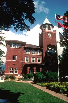
The Rhea County Courthouse is a historic county courthouse in the center of Dayton, the county seat of Rhea County, Tennessee. Built in 1891, it is famous as the scene of the Scopes trial of July 1925, in which teacher John T. Scopes faced charges for including Charles Darwin's theory of evolution in his public school lesson. The trial became a clash of titans between lawyers William Jennings Bryan for the prosecution and Clarence Darrow for the defense, and epitomizes the tension between fundamentalism and modernism in a wide range of aspects of American society. The courthouse, now also housing a museum devoted to the trial, was designated a National Historic Landmark in 1976.

<span class="mw-page-title-main">Rhea County High School</span> School in Evensville, Tennessee, United States

Rhea County High School is a high school in Evensville, Tennessee. It serves Rhea County, Tennessee, which includes Dayton, Spring City and Graysville. It has an enrollment of 1,469. Its mascot is a golden eagle. It is a part of Rhea County Schools.

Rhea County Department of Education, also known as Rhea County Schools or Rhea School District, is a school district headquartered in Dayton, Tennessee. It serves students in the county, except for the City of Dayton, for elementary and middle school, as well as high school students throughout the entire county.

References

  1. Tennessee Blue Book , 2005–2006, pp. 618-625.
  2. Larry Miller, Tennessee Place Names (Indiana University Press, 2001), p. 59.
  3. "ArcGIS REST Services Directory". United States Census Bureau. Retrieved October 15, 2022.
  4. 1 2 "Census Population API". United States Census Bureau. Retrieved October 15, 2022.
  5. 1 2 "U.S. Census website". United States Census Bureau . Retrieved January 31, 2008.
  6. "US Board on Geographic Names". United States Geological Survey. October 25, 2007. Retrieved January 31, 2008.
  7. "Find a County". National Association of Counties. Archived from the original on May 31, 2011. Retrieved June 7, 2011.
  8. "2010 City Population and Housing Occupancy Status". U.S. Census Bureau. Retrieved April 11, 2012.[ dead link ]
  9. Gannett, Henry (1905). The Origin of Certain Place Names in the United States. Govt. Print. Off. p.  101.
  10. "Digital History". www.digitalhistory.uh.edu. Retrieved September 30, 2015.
  11. Moore, Randy (September 1, 2001). "The Lingering Impact of the Scopes Trial on High School Biology Textbooks". BioScience. 51 (9): 790–796. doi:10.1641/0006-3568(2001)051[0790:TLIOTS]2.0.CO;2. ISSN   0006-3568. S2CID   85706061.
  12. Randal Rust. "The Scopes Trial". Tennessee Encyclopedia. Retrieved February 4, 2019.
  13. "US Gazetteer files: 2010, 2000, and 1990". United States Census Bureau. February 12, 2011. Retrieved April 23, 2011.
  14. "NowData - NOAA Online Weather Data". National Oceanic and Atmospheric Administration. Retrieved October 10, 2021.
  15. "Station: Dayton 2SE, TN". U.S. Climate Normals 2020: U.S. Monthly Climate Normals (1991-2020). National Oceanic and Atmospheric Administration. Retrieved October 10, 2021.
  16. "Census of Population and Housing: Decennial Censuses". United States Census Bureau . Retrieved March 4, 2012.
  17. "Incorporated Places and Minor Civil Divisions Datasets: Subcounty Resident Population Estimates: April 1, 2010 to July 1, 2012". Population Estimates. U.S. Census Bureau. Archived from the original on June 11, 2013. Retrieved December 11, 2013.
  18. "Explore Census Data". data.census.gov. Retrieved December 27, 2021.
  19. "Greater Chattanooga Economic Partnership - Rhea County Fact Sheet 2019" (PDF). Retrieved November 3, 2019.
  20. "Dayton Factory - Updates". Nokian Tyres. Retrieved November 3, 2019.
  21. Kite, Steve (November 3, 2016). "Dayton Lands Fishermen and Nets Huge Economic Boost - WRCBtv.com | Chattanooga News, Weather & Sports". WRCBtv.com. Retrieved November 8, 2016.
  22. "The Walmart FLW – "Battle of Chickamauga"". World Fishing Network. July 4, 2013. Archived from the original on January 31, 2016. Retrieved November 8, 2016.
  23. "Fish Dayton Events" . Retrieved November 3, 2019.
  24. "STULZ Air Technology Systems Locates Manufacturing Plant in Dayton, Tennessee". March 8, 2019.
  25. "STULZ Announces the Addition of a New Manufacturing Plant and High Skilled Jobs in Dayton, Tennessee - HVAC Insider". July 18, 2019.
  26. "Welding Technology". October 21, 2014.
  27. "2020 CENSUS - SCHOOL DISTRICT REFERENCE MAP: Rhea County, TN" (PDF). U.S. Census Bureau . Retrieved June 7, 2022. - Rhea County High School is not indicated on this map, but it is the sole high school of Rhea County Schools, and therefore students from Dayton would go there.
  28. Home Archived January 29, 2012, at the Wayback Machine . Rhea Central Elementary School. Retrieved on July 5, 2017. "Address: 1005 Delaware Ave. Dayton, TN 37321 " - Compare to Dayton city limits
  29. "Home". Graysville Elementary School. Retrieved June 7, 2022. 606 Long Street Dayton, TN 37321 - Compare to Map of Graysville
  30. Cornwell 1988, p. 710.

Works cited