Waynesboro, Tennessee

Last updated

Waynesboro, Tennessee
Wayne-County-Courthouse-SE-tn2.jpg
Wayne County Courthouse
Motto(s): 
Progressing toward our future, through an understanding of our past [1]
Wayne County Tennessee Incorporated and Unincorporated areas Waynesboro Highlighted 4778600.svg
Location of Waynesboro in Wayne County, Tennessee.
USA Tennessee location map.svg
Red pog.svg
Waynesboro, Tennessee
Location in Tennessee
Usa edcp location map.svg
Red pog.svg
Waynesboro, Tennessee
Waynesboro, Tennessee (the United States)
Coordinates: 35°19′10″N87°45′44″W / 35.31944°N 87.76222°W / 35.31944; -87.76222
Country United States
State Tennessee
County Wayne
Established1821 [2]
Incorporated1850 [3]
Named for General Anthony Wayne [4]
Area
[5]
  Total4.28 sq mi (11.10 km2)
  Land4.28 sq mi (11.10 km2)
  Water0.00 sq mi (0.00 km2)
Elevation
748 ft (228 m)
Population
 (2020) [6]
  Total2,317
  Density540.85/sq mi (208.81/km2)
Time zone UTC-6 (Central (CST))
  Summer (DST) UTC-5 (CDT)
ZIP code
38485
Area code 931
FIPS code 47-78600 [7]
GNIS feature ID1326575 [8]
Website www.cityofwaynesboro.org

Waynesboro is a city in and the county seat of Wayne County, Tennessee, United States. [9] The population was 2,449 at the 2010 census, up from 2,228 in 2000. [10]

Contents

History

Waynesboro was founded in 1821 as a county seat for the newly created Wayne County. The city initially consisted of a 40-acre (16 ha) plot that included the courthouse and jail. A school, Ashland Academy, was established in 1843. [11] The city incorporated in 1850. [3]

Geography

Waynesboro is concentrated around the junction of State Route 13 and U.S. Route 64, 105 miles (169 km) south of Nashville, and 135 miles (217 km) east Memphis. State Route 99, which intersects US 64 in eastern Waynesboro, connects the city with Hohenwald to the northeast. The Natchez Trace Parkway intersects US 64 a few miles east of Waynesboro.

Waynesboro lies along the banks of the Green River, which slices a narrow valley oriented north-to-south en route to its mouth along the Buffalo River to the north. Hurricane Creek, which approaches from the southeast, empties into the Green River just north of the city. Much of the forest northwest of Waynesboro is part of the Eagle Creek Wildlife Management Area.

According to the United States Census Bureau, the city has a total area of 2.5 square miles (6.5 km2), all of it land.

Climate

Climate data for Waynesboro, Tennessee (1991–2020 normals, extremes 1893–present)
MonthJanFebMarAprMayJunJulAugSepOctNovDecYear
Record high °F (°C)79
(26)
82
(28)
91
(33)
92
(33)
96
(36)
106
(41)
108
(42)
106
(41)
107
(42)
96
(36)
86
(30)
76
(24)
108
(42)
Mean daily maximum °F (°C)48.9
(9.4)
53.2
(11.8)
62.0
(16.7)
71.9
(22.2)
78.6
(25.9)
85.3
(29.6)
88.4
(31.3)
88.2
(31.2)
83.1
(28.4)
73.1
(22.8)
60.9
(16.1)
51.7
(10.9)
70.4
(21.3)
Daily mean °F (°C)37.8
(3.2)
41.2
(5.1)
48.8
(9.3)
57.7
(14.3)
65.9
(18.8)
73.7
(23.2)
77.2
(25.1)
76.2
(24.6)
70.0
(21.1)
59.0
(15.0)
47.7
(8.7)
40.5
(4.7)
58.0
(14.4)
Mean daily minimum °F (°C)26.7
(−2.9)
29.3
(−1.5)
35.7
(2.1)
43.4
(6.3)
53.1
(11.7)
62.1
(16.7)
65.9
(18.8)
64.1
(17.8)
56.8
(13.8)
44.9
(7.2)
34.4
(1.3)
29.4
(−1.4)
45.5
(7.5)
Record low °F (°C)−21
(−29)
−20
(−29)
2
(−17)
19
(−7)
27
(−3)
34
(1)
41
(5)
41
(5)
29
(−2)
16
(−9)
−5
(−21)
−9
(−23)
−21
(−29)
Average precipitation inches (mm)4.99
(127)
5.61
(142)
5.56
(141)
5.59
(142)
5.83
(148)
5.27
(134)
5.36
(136)
4.43
(113)
4.38
(111)
4.40
(112)
4.19
(106)
6.18
(157)
61.79
(1,569)
Average snowfall inches (cm)0.4
(1.0)
0.4
(1.0)
0.5
(1.3)
0.0
(0.0)
0.0
(0.0)
0.0
(0.0)
0.0
(0.0)
0.0
(0.0)
0.0
(0.0)
0.0
(0.0)
0.0
(0.0)
0.0
(0.0)
1.3
(3.3)
Average precipitation days (≥ 0.01 in)11.110.411.810.210.610.510.09.17.97.99.211.4120.1
Average snowy days (≥ 0.1 in)0.50.70.20.00.00.00.00.00.00.00.00.21.6
Source: NOAA [12] [13]

Demographics

Historical population
CensusPop.Note
1880 236
1890 2391.3%
1910 357
1940 768
1950 1,14749.3%
1960 1,34317.1%
1970 1,98347.7%
1980 2,1096.4%
1990 1,824−13.5%
2000 2,22822.1%
2010 2,4499.9%
2020 2,317−5.4%
Sources: [14] [15] [6]
Buildings along the courthouse square Waynesboro-courthouse-square-tn1.jpg
Buildings along the courthouse square

2020 census

Waynesboro racial composition [16]
RaceNumberPercentage
White (non-Hispanic)2,12791.8%
Black or African American (non-Hispanic)542.33%
Native American 30.13%
Asian 140.6%
Other/Mixed 703.02%
Hispanic or Latino 492.11%

As of the 2020 United States census, there were 2,317 people, 937 households, and 655 families residing in the city.

2000 census

As of the census [7] of 2000, there were 2,228 people, 954 households, and 601 families residing in the city. The population density was 904.2 inhabitants per square mile (349.1/km2). There were 1,071 housing units at an average density of 434.7 per square mile (167.8/km2). The racial makeup of the city was 97.04% White, 1.39% African American, 0.22% Native American, 0.45% Asian, 0.09% Pacific Islander, 0.22% from other races, and 0.58% from two or more races. Hispanic or Latino of any race were 1.03% of the population.

There were 954 households, out of which 27.7% had children under the age of 18 living with them, 47.1% were married couples living together, 13.1% had a female householder with no husband present, and 37.0% were non-families. 35.1% of all households were made up of individuals, and 18.3% had someone living alone who was 65 years of age or older. The average household size was 2.21 and the average family size was 2.84.

In the city, the population was spread out, with 23.1% under the age of 18, 7.7% from 18 to 24, 25.9% from 25 to 44, 23.4% from 45 to 64, and 19.9% who were 65 years of age or older. The median age was 40 years. For every 100 females, there were 87.1 males. For every 100 females age 18 and over, there were 79.6 males.

The median income for a household in the city was $25,196, and the median income for a family was $33,917. Males had a median income of $27,263 versus $17,379 for females. The per capita income for the city was $15,037. About 14.0% of families and 16.3% of the population were below the poverty line, including 16.9% of those under age 18 and 15.2% of those age 65 or over.

Education

Media

Radio stations

Infrastructure

Highways

Notable people

Related Research Articles

<span class="mw-page-title-main">Putnam County, Missouri</span> County in Missouri, United States

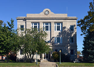
Putnam County is in north central Missouri. At the 2020 census, the population was 4,681. Its county seat is Unionville. The county was organized February 28, 1845, and named for Israel Putnam, a hero in the French and Indian War and a general in the American Revolutionary War.

<span class="mw-page-title-main">Marshall County, Alabama</span> County in Alabama, United States

Marshall County is a county of the state of Alabama, United States. As of the 2020 census the population was 97,612. Its county seat is Guntersville. A second courthouse is in Albertville. Its name is in honor of John Marshall, famous Chief Justice of the United States. Marshall County is a dry county, with the exception of the five cities of Albertville, Arab, Grant, Guntersville, and Boaz. Marshall County comprises the Albertville, AL Micropolitan Statistical Area, which is also included in the Huntsville-Decatur-Albertville, AL Combined Statistical Area.

<span class="mw-page-title-main">Waynesboro, Virginia</span> Independent city in Virginia, United States

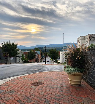
Waynesboro is an independent city in the Commonwealth of Virginia. It is a principal city of the Staunton-Waynesboro Metropolitan Statistical Area. Waynesboro is located in the Shenandoah Valley and is surrounded by Augusta County. As of the 2020 census, the population was 22,196.

<span class="mw-page-title-main">Wayne County, Tennessee</span> County in Tennessee, United States

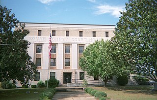
Wayne County is a county located in south central Tennessee, along the Alabama border. As of the 2020 census, the population was 16,232. Its county seat is Waynesboro. The county is named after General "Mad Anthony" Wayne, a prominent military leader in the American Revolutionary War.

<span class="mw-page-title-main">Walker County, Georgia</span> County in Georgia, United States

Walker County is a county located in the northwestern part of the U.S. state of Georgia. As of the 2020 census, the population was 67,654, down from 68,756 in 2010. The county seat is LaFayette. The county was created on December 18, 1833, from land formerly belonging to the Cherokee Indian Nation.

<span class="mw-page-title-main">Valley, Alabama</span> City in Alabama, United States

Valley is a city in Chambers County, Alabama, United States. Valley was incorporated in 1980 combining the four textile mill villages of Fairfax, Langdale, River View, and Shawmut. As of the 2010 census it had a population of 9,524. The city lies on the western bank of the Chattahoochee River, the state border between Alabama and Georgia. Valley is a pilot city for the Alabama Communities of Excellence program, a non-profit that partners with governments, businesses, and universities to prepare participating communities for a more vibrant future. It is included in the LaGrange, Georgia Micropolitan Statistical Area, which is included in the Greater Atlanta Combined Statistical Area.

<span class="mw-page-title-main">Arab, Alabama</span> City in Alabama, United States

Arab is a city in Marshall County in the northern part of the U.S. state of Alabama, located 10 miles (16 km) from Guntersville Lake and Guntersville Dam, and is included in the Huntsville-Decatur Combined Statistical Area. The population was 8,461 at the 2020 census.

<span class="mw-page-title-main">New Hartford, Connecticut</span> Town in Connecticut, United States

New Hartford is a town in Litchfield County, Connecticut, United States. The population was 6,658 at the 2020 census. The town is part of the Northwest Hills Planning Region. The town center is defined by the U.S. Census Bureau as the New Hartford Center census-designated place (CDP). The town is mainly a rural community consisting of farms, homes, and parks. Brodie Park and Ski Sundown are located in New Hartford.

<span class="mw-page-title-main">Waynesboro, Mississippi</span> City in Mississippi, United States

Waynesboro is a city in Wayne County, Mississippi, United States. The population was 5,043 at the 2010 census. It is the county seat of Wayne County.

Rouzerville is an unincorporated community and census-designated place (CDP) in Franklin County, Pennsylvania, United States. The population was 903 at the 2020 census.

Wayne Heights is a census-designated place (CDP) in Franklin County, Pennsylvania, United States. The population was 2,606 at the 2020 census.

<span class="mw-page-title-main">Waynesboro, Pennsylvania</span> Borough in Pennsylvania, United States

Waynesboro is a borough in Franklin County, Pennsylvania, United States. Located on the southern border of the state, Waynesboro is in the Cumberland Valley between Hagerstown, Maryland, and Chambersburg, Pennsylvania. It is part of Chambersburg, PA Micropolitan Statistical Area, which is part of the Washington–Baltimore metropolitan area. It is two miles north of the Mason–Dixon line and close to Camp David and the Raven Rock Mountain Complex.

<span class="mw-page-title-main">Elkton, Tennessee</span> City in Tennessee, United States

Elkton is a city in Giles County, Tennessee, United States. The population was 578 at the 2010 census.

<span class="mw-page-title-main">Tusculum, Tennessee</span> City in Tennessee, United States

Tusculum is a city in Greene County, Tennessee, United States. The population was 3,298 at the 2020 census. It is the site of Tusculum University, the oldest university in Tennessee and the 28th oldest in the United States. Tusculum is a suburb of nearby Greeneville. The population of both Greeneville and Tusculum combined was approximately 18,777 at the 2020 census.

<span class="mw-page-title-main">Savannah, Tennessee</span> City in Tennessee, United States

Savannah is a city in and the county seat of Hardin County, Tennessee, United States. The population was 7,213 at the 2020 census. Savannah is located along the east side of the Tennessee River.

<span class="mw-page-title-main">Collinwood, Tennessee</span> City in Tennessee, United States

Collinwood is a city in Wayne County, Tennessee, United States. The population was 982 at the 2010 census, down from 1,024 in 2000.

<span class="mw-page-title-main">Martin, Tennessee</span> City in Tennessee, United States

Martin is a city in Weakley County, Tennessee, United States. The population was 10,825 according to the 2020 census. The city is the home of the University of Tennessee at Martin.

<span class="mw-page-title-main">State Line, Mississippi</span> Town in Mississippi, United States

State Line is a town in Greene and Wayne counties, Mississippi, in the United States. The population was 452 at the 2020 census.

<span class="mw-page-title-main">Ardmore, Tennessee</span> City in Tennessee, United States

Ardmore is a city in Giles and Lincoln counties, Tennessee, United States. The population was 1,217 at the 2020 census. Ardmore is the site of a Tennessee Department of Tourist Development Welcome Center. It borders its sister city, Ardmore, Alabama.

<span class="mw-page-title-main">Grottoes, Virginia</span> Town in Virginia, United States

Grottoes is an incorporated town in Augusta and Rockingham counties in the U.S. state of Virginia. The population was 2,668 at the 2010 census.

References

  1. Waynesboro official website. Retrieved: March 1, 2013.
  2. Bob Rains, "Wayne County," Tennessee Encyclopedia of History and Culture. Retrieved: March 1, 2013.
  3. 1 2 Tennessee Blue Book , 2005-2006, pp. 618-625.
  4. Nancy Capace, Encyclopedia of Tennessee (North American Book Distributors, 2000), p. 229.
  5. "ArcGIS REST Services Directory". United States Census Bureau. Retrieved October 15, 2022.
  6. 1 2 "Census Population API". United States Census Bureau. Retrieved October 15, 2022.
  7. 1 2 "U.S. Census website". United States Census Bureau . Retrieved January 31, 2008.
  8. U.S. Geological Survey Geographic Names Information System: Waynesboro
  9. "Find a County". National Association of Counties. Retrieved June 7, 2011.
  10. 2010 U.S. Census Archived December 21, 2012, at the Wayback Machine , U.S. Census Bureau. Accessed November 9, 2016.
  11. Austin Foster and Mel Foster, Counties of Tennessee (Genealogical Publishing Company, 2009), p. 92.
  12. "NowData - NOAA Online Weather Data". National Oceanic and Atmospheric Administration. Retrieved October 2, 2021.
  13. "Station: Waynesboro, TN". U.S. Climate Normals 2020: U.S. Monthly Climate Normals (1991–2020). National Oceanic and Atmospheric Administration. Retrieved October 2, 2021.
  14. "Census of Population and Housing: Decennial Censuses". United States Census Bureau . Retrieved March 4, 2012.
  15. "Incorporated Places and Minor Civil Divisions Datasets: Subcounty Resident Population Estimates: April 1, 2010 to July 1, 2012". Population Estimates. U.S. Census Bureau. Archived from the original on June 11, 2013. Retrieved December 11, 2013.
  16. "Explore Census Data". data.census.gov. Retrieved December 25, 2021.
  17. Radio and TV Search, FCC website. Accessed November 9, 2016.