Kannur is one of the 14 districts along the west coast in the state of Kerala, India. The city of Kannur is the district headquarters and gives the district its name. The old name, Cannanore, is the anglicized form of the Malayalam name "Kannur". Kannur district is bounded by Kasaragod District to the north, Kozhikode district to the south, Mahé district to the southwest and Wayanad District to the southeast. To the east, the district is bounded by the Western Ghats, which forms the border with the state of Karnataka. The Arabian Sea lies to the west. Paithalmala is the highest point in Kannur District (1,372m). Enclosed within the southern part of the district is the Mahé district of the Union Territory of Puducherry. The district was established in 1957.

Thalassery, formerly Tellicherry, is a municipality and commercial city on the Malabar Coast in Kannur district in the state of Kerala, India, bordered by the districts of Mahe, Kozhikode, Wayanad, Kasaragod and Kodagu (Karnataka). Thalassery municipality has a population of just under 100,000 as of 2011 census. Thalassery Heritage City has an area of 23.98 square kilometres (9.26 sq mi). Thalassery has an altitude ranging from 2.5 to 30 metres above mean sea-level.
Muzhappilangad (മുഴപ്പിലങ്ങാട്) is a coastal census town near Thalassery in Kannur district in the Indian state of Kerala. It is a suburb of kannur city
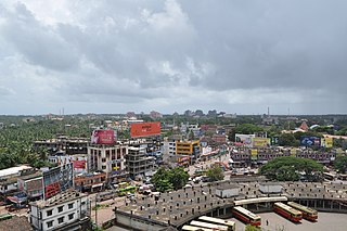
Kannur, formerly known in English as Cannanore, is a city and a municipal corporation in the state of Kerala, India. It is the administrative headquarters of the Kannur district and situated 274 kilometres (170 mi) north of the major port city and commercial hub Kochi and 137 kilometres (85 mi) south of the major port city and a commercial hub, Mangalore. During the period of British colonial rule in India, when Kannur was a part of the Malabar District, the city was known as Cannanore. Kannur is the sixth largest urban agglomeration in Kerala. As of 2011 census, Kannur Municipal Corporation, the local body which administers mainland area of city, had a population of 232,486.

Gudalur is a municipality and taluk in Nilgiris district in the Indian state of Tamil Nadu.

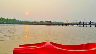
Muzhappilangad Beach is a drive-in beach in the Kannur district of Kerala, on the Malabar Coast of India. It stretches across 4 kilometres in length. In 2016, it was featured among the six "best beaches for driving" in an article published by BBC - Autos.

Malabar District, also known as Malayalam District, was an administrative district on the southwestern Malabar Coast of Bombay Presidency (1792–1800), Madras Presidency (1800–1937), Madras Province (1937–1950) and finally, Madras State (1950–1956) in India. It was the most populous and the third-largest district in the erstwhile Madras State. The historic town of Calicut was the admisnitrative headquarters of this district.
Koyilandy is a major town municipality and a taluk in Kozhikode district, Kerala on the Malabar Coast. The historical town is located right in the middle of the coast of Kozhikode district, between Kozhikode (Calicut) and Kannur, on National Highway 66.
Kottayam-Malabar is a census town near Kuthuparamba in Kannur district of Kerala state in India. It is different from the city of Kottayam in Kottayam district of the same state.
Nelliyalam is a panchayat town in The Nilgiris district in the Indian state of Tamil Nadu. As of 2011, the town had a population of 44,590.
Palayad is a census town in Thalassery Taluk in the Indian state of Kerala.
Panoor is a Municipality in the district of Kannur in the state of Kerala, India. The town is the main market place for the farmer communities in the surrounding regions. Panoor is one of the main suburbs of the City of Thalassery. Panoor got municipal status when the Government of Kerala decided to upgrade Panoor Grama Panchayat and added with other Panchayats, as Panoor Municipality in 2015.

Kasaragod is one of the 14 districts in the southern Indian state of Kerala. Its northern border Thalappady is located just 9 km south to Ullal, which is the southernmost portion of the major port city Mangalore, on the southwestern Malabar coast of India.

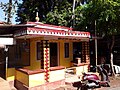
Sree Andalurkavu is a very ancient and famous and prominent Thiyya Community Urayima temple in Andalur in Dharmadam village of Kannur district, Kerala, India. It counts among the Abhimana Kshethras of Vaishnavite Shrines. This ancient temple is in the name of Lord Rama and the main festival is celebrated in mid-February: the first week of the month "Kumbam" of the Malayalam calendar. This Kavu also has a story of how the Kalaripayat warrior Thacholi Othenan, who once caused trouble in this Thiyar-dominated Kavu Andalur of Thalassery, was punished and defeated by the Thiyars and crossed the country through the bridge.

North Malabar refers to the geographic area of southwest India covering the state of Kerala's present day Kasaragod, Kannur, and Wayanad districts, and the taluks of Vatakara and Koyilandy in the Kozhikode District of Kerala and the entire Mahé Sub-Division of the Union Territory of Puducherry. Traditionally North Malabar has been defined as the northern portion of the erstwhile Malabar District which lies between Chandragiri River and Korapuzha River. The region between Netravathi River and Chandragiri River, which included the portions between Mangalore and Kasaragod, are also often included in the term North Malabar, as the Kumbla dynasty in the southernmost region of Tulu Nadu, had a mixed lineage of Malayali Nairs and Tuluva Brahmins.
Pandalur taluk is a taluk of Nilgiris district of the Indian state of Tamil Nadu. The headquarters of the taluk is the town of Pandalur.

Arakkal Kingdom was a Muslim kingdom in Kannur town in Kannur district, in the state of Kerala, South India. The king was called Ali Raja and the ruling queen was called Arakkal Beevi. Arakkal kingdom included little more than the Cannanore town and the southern Laccadive Islands, originally leased from the Kolattiri. They owed allegiance to the Kolattiri rulers, whose ministers they had been at one time. The rulers followed the Marumakkathayam system of matrilineal inheritance, a system that is unique to a section of Hindus of Kerala. Under Marumakkathayam, the succession passes to the male offspring of its female members, in other words from a man to his sister's son and so forth. As the only Muslim rulers in Malabar, they saw the rise of Hyder Ali, de facto ruler of the Mysore Sultanate as the opportunity to increase their own power at the expense of Chirakkal, and invited him to invade Kerala. Ali Raja Arakkal Sultan Afsal Ashraf living in Konni Panchayat of Pathanamthitta district is the living heir of the Arakkal dynasty.

Kannur, formerly known in English as Cannanore, Arabic as Kannanur, and Portuguese as Cananor, is a city and a Municipal Corporation in North Malabar region, state of Kerala, India. It is the largest city in North Malabar, which is the northernmost region of Kerala. It is sometimes identified Kolathunadu, which was ruled by the Kolathiris. In the 12th and 13th centuries there was trade with Persia and Arabia.

The Kannur Municipal Corporation is the municipal corporation that administers the city of Kannur, Kerala. Established in 2015, the Corporation's first mayor was E. P. Latha. Kannur Corporation has two assembly constituencies – Kannur Assembly constituency and Azhikode Assembly constituency – both of which are part of the Kannur parliamentary constituency. The Corporation is headed by a Mayor and council, and manages 78.35 km2 of Kannur city, with a population of about 232,486 within that area. Kannur Municipal Corporation has been formed with functions to improve the infrastructure of town.

![Dharmadam Island dh[?]mttN turutt.jpg](http://upload.wikimedia.org/wikipedia/commons/thumb/6/66/%E0%B4%A7%E0%B5%BC%E0%B4%AE%E0%B4%9F%E0%B4%82_%E0%B4%A4%E0%B5%81%E0%B4%B0%E0%B5%81%E0%B4%A4%E0%B5%8D%E0%B4%A4%E0%B5%8D.jpg/220px-%E0%B4%A7%E0%B5%BC%E0%B4%AE%E0%B4%9F%E0%B4%82_%E0%B4%A4%E0%B5%81%E0%B4%B0%E0%B5%81%E0%B4%A4%E0%B5%8D%E0%B4%A4%E0%B5%8D.jpg)