East Hampton North, New York

Last updated
East Hampton North, New York
Eh-north-map.png
USA New York location map.svg
Red pog.svg
East Hampton North
Coordinates: 40°58′16″N72°11′20″W / 40.97111°N 72.18889°W / 40.97111; -72.18889 Coordinates: 40°58′16″N72°11′20″W / 40.97111°N 72.18889°W / 40.97111; -72.18889
Country United States
State New York
County Suffolk
Town East Hampton
Area
[1]
  Total5.57 sq mi (14.43 km2)
  Land5.57 sq mi (14.43 km2)
  Water0.00 sq mi (0.00 km2)
Population
 (2020)
  Total5,377
  Density965.00/sq mi (372.61/km2)
Time zone UTC-5 (Eastern (EST))
  Summer (DST) UTC-4 (EDT)
FIPS code 36-22200

East Hampton North is a census-designated place (CDP) in Suffolk County, New York, United States. At the 2010 census, the population was 4,142. [2]

Contents

Geography

East Hampton North is located at 40°58′16″N72°11′20″W / 40.97111°N 72.18889°W / 40.97111; -72.18889 (40.971060, -72.188759). [3]

According to the United States Census Bureau, the CDP has an area of 5.6 square miles (14.6 km2), all land. [2]

Demographics

Historical population
CensusPop.
2020 5,377
U.S. Decennial Census [4]

As of the census [5] of 2000, there were 3,587 people, 1,445 households, and 881 families residing in the CDP. The population density was 643.1/mi2 (248.2/km2). There were 2,251 housing units at an average density of 403.6/mi2 (155.8/km2). The racial makeup of the CDP was 82.46% White, 7.39% African American, 0.08 Native American, 1.62% Asian, 0.08% Pacific Islander, 5.94% from other races, and 2.43% from two or more races. Hispanic or Latino of any race were 16.62% of the population.

There were 1,445 households, out of which 27.3% had children under the age of 18 living with them, 44.2% were married couples living together, 12.2% had a female householder with no husband present, and 39.0% were non-families. 31.9% of all households were made up of individuals, and 16.8% had someone living alone who was 65 years of age or older. The average household size was 2.47 and the average family size was 3.07.

In the CDP, the population was spread out, with 22.3% under the age of 18, 6.7% from 18 to 24, 28.0% from 25 to 44, 25.8% from 45 to 64, and 17.2% who were 65 years of age or older. The median age was 41 years. For every 100 females, there were 92.6 males. For every 100 females age 18 and over, there were 90.2 males.

The median income for a household in the CDP was $45,347, and the median income for a family was $55,357. Males had a median income of $38,566 versus $29,750 for females. The per capita income for the CDP was $25,725. About 10.3% of families and 12.2% of the population were below the poverty line, including 20.5% of those under the age of 18 and 4.2% of those ages 65 or older.

Schools

See also

Related Research Articles

<span class="mw-page-title-main">Harlem Heights, Florida</span> Census-designated place in Florida, United States

Harlem Heights is an unincorporated community and census-designated place (CDP) in Lee County, Florida, United States. The population was 1,975 at the 2010 census, up from 1,065 at the 2000 census. It is part of the Cape Coral-Fort Myers, Florida Metropolitan Statistical Area.

<span class="mw-page-title-main">Gibsonia, Florida</span> Unincorporated community in Florida, United States

Gibsonia is a former census-designated place (CDP) in Polk County, Florida, United States. The population was 4,507 at the 2000 census. Most of the community's core is now part of neighboring Lakeland. It is part of the Lakeland–Winter Haven Metropolitan Statistical Area.

<span class="mw-page-title-main">Kalaheo, Hawaii</span> Census-designated place in Hawaii, United States

Kalāheo is an unincorporated community and census-designated place (CDP) in Kauaʻi County, island of Kauaʻi, Hawaiʻi, United States. The population was 4,996 at the 2020 census, up from 3,913 at the 2000 census.

<span class="mw-page-title-main">Oak Park, Indiana</span> CDP in Indiana, United States

Oak Park is a census-designated place (CDP) in Clark County, Indiana, United States. The population was 5,379 at the 2000 census.

<span class="mw-page-title-main">Brunswick Station, Maine</span> Census-designated place in Maine, United States

Brunswick Station was a census-designated place (CDP) within the town of Brunswick in Cumberland County, Maine, United States. The population was 578 at the 2010 census. It consists of area that was part of the former Naval Air Station Brunswick and was part of the Portland–South Portland–Biddeford, Maine Metropolitan Statistical Area. The 2020 census shows it as part of the Brunswick CDP.

<span class="mw-page-title-main">Springdale, New Jersey</span> Census-designated place in New Jersey, United States

Springdale is an unincorporated community and census-designated place (CDP) located within Cherry Hill Township, in Camden County, New Jersey, United States. As of the 2010 United States Census, the section population was 14,518.

<span class="mw-page-title-main">Hampton Manor, New York</span> CDP in New York, United States

Hampton Manor is a census-designated place in the town of East Greenbush in Rensselaer County, New York, United States. The population was 2,417 at the 2010 census.

<span class="mw-page-title-main">Bridgehampton, New York</span> Hamlet and census-designated place in New York, United States

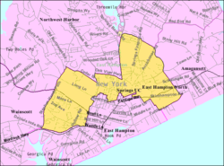
Bridgehampton is a hamlet and census-designated place (CDP) on the South Fork of Suffolk County, New York, United States. The population was 1,756 at the 2010 census.

<span class="mw-page-title-main">Shinnecock Hills, New York</span> Hamlet and census-designated place in New York, United States

Shinnecock Hills is a hamlet in Suffolk County, New York, United States. The population was 2,188 at the 2010 census. It is the home of a leading golf club, Shinnecock Hills Golf Club. Ownership of the area has been the subject of a 2005 lawsuit filed by the Shinnecock Indian Nation.

<span class="mw-page-title-main">South Rosemary, North Carolina</span> Census-designated place in North Carolina, United States

South Rosemary is an unincorporated area and census-designated place (CDP) in Halifax County, North Carolina, United States. The population was 2,836 at the 2010 census. It is part of the Roanoke Rapids, North Carolina Micropolitan Statistical Area.

Spring Ridge is a census-designated place (CDP) in Spring Township, Berks County, Pennsylvania. The population was 1,003 at the 2010 census.

<span class="mw-page-title-main">Richboro, Pennsylvania</span> Census-designated place in Pennsylvania, United States

Richboro is a census-designated place (CDP) in Northampton Township, Bucks County, Pennsylvania, United States. The population was 6,378 during the 2020 census.

<span class="mw-page-title-main">Madisonburg, Pennsylvania</span> Census designated place in Pennsylvania, United States

Madisonburg is an unincorporated community and census-designated place (CDP) in Miles Township, Centre County, Pennsylvania, United States. It is part of the State College, Pennsylvania Metropolitan Statistical Area. The population was 168 at the 2010 census.

<span class="mw-page-title-main">Edgewood, Northumberland County, Pennsylvania</span> CDP in Pennsylvania, United States

Edgewood is a census-designated place (CDP) located in Coal Township, in Northumberland County, Pennsylvania, United States. The population was 2,619 at the 2000 census.

<span class="mw-page-title-main">Donaldson, Pennsylvania</span> CDP in Pennsylvania, United States

Donaldson is a census-designated place (CDP) in Frailey Township, Schuylkill County, Pennsylvania, United States. The population was 325 at the 2000 census.

<span class="mw-page-title-main">Okauchee Lake, Wisconsin</span> CDP in Wisconsin, United States

Okauchee Lake is a census-designated place (CDP) in Waukesha County, Wisconsin, United States. The population was 4,422 at the 2010 census. Okauchee Lake is located in the town of Oconomowoc.

<span class="mw-page-title-main">Winchendon (CDP), Massachusetts</span> Census-designated place in Massachusetts, United States

Winchendon is a census-designated place (CDP) in the town of Winchendon in Worcester County, Massachusetts, United States. The population was 4,213 at the 2010 census.

Hampton is a census-designated place (CDP) comprising the town center and surrounding developed areas of the town of Hampton, Rockingham County, New Hampshire, United States. The population of the CDP was 9,597 at the 2020 census, out of 16,214 in the entire town.

<span class="mw-page-title-main">Shelter Island (CDP), New York</span> Hamlet and census-designated place in New York, United States

Shelter Island is a hamlet and census-designated place (CDP) within the Town of Shelter Island in Suffolk County, New York, United States. The population was 1,333 at the 2010 census. The village of Dering Harbor and the CDP of Shelter Island Heights make up the rest of the town.

New Hampton is a census-designated place (CDP) and the main village in the town of New Hampton in Belknap County, New Hampshire, United States. The population was 373 at the 2020 census, out of 2,377 people in the entire town of New Hampton.

References

  1. "ArcGIS REST Services Directory". United States Census Bureau. Retrieved September 20, 2022.
  2. 1 2 "Geographic Identifiers: 2010 Demographic Profile Data (G001): East Hampton North CDP, New York". U.S. Census Bureau, American Factfinder. Archived from the original on 2020-02-12. Retrieved 2012-12-27.
  3. "US Gazetteer files: 2010, 2000, and 1990". United States Census Bureau. 2011-02-12. Retrieved 2011-04-23.
  4. "Census of Population and Housing". Census.gov. Retrieved June 4, 2016.
  5. "U.S. Census website". United States Census Bureau . Retrieved 2008-01-31.