Easter Microplate

Last updated
Easter Microplate
Easter Microplate Boundaries.png
Easter microplate (from GeoMapApp) with rough plate boundaries. [1]
Four spreading sections make up the eastern border. The west section comes from the north side down in a southwest manner, until it breaks off and becomes the southwest section. Triple junctions on north and south ends are not well defined.
Type Micro
Coordinates 25°00′S114°00′W / 25.000°S 114.000°W / -25.000; -114.000 Coordinates: 25°00′S114°00′W / 25.000°S 114.000°W / -25.000; -114.000
Approximate area160000
Movement1East
Speed150 to 140 millimetres (2.0 to 5.5 in)/yr
FeaturesBordering:
  Pacific Plate (west)
  Nazca Plate (east)
1Relative to the African Plate

Easter Plate is a tectonic microplate located to the west of Easter Island off the west coast of South America in the middle of the Pacific Ocean, bordering the Nazca Plate to the east and the Pacific Plate to the west. [2] It was discovered from looking at earthquake distributions that were offset from the previously perceived Nazca-Pacific Divergent boundary. [3] This young plate is 5.25 million years old and is considered a microplate because it is small with an area of approximately 160,000 square kilometres (62,000 sq mi). [4] Seafloor spreading along the Easter microplate's borders have some of the highest global rates, ranging from 50 to 140 millimetres (2.0 to 5.5 in)/yr. [5]

Contents

Structure and tectonics (present)

From the 1970s to 1990s, multiple efforts were made to collect data on the area, including several magnetic and gravitational anomaly surveys. These surveys show that Easter plate is uniquely shallow, bordered by spreading centers and transform boundaries, with a triple junction located at the southern and northern tip. [6]

Along the eastern border, there are several spreading centers south of 27° S and 3 northward propagating rift to the north of 27° S. The axis further north is a graben reaching a depth of approximately 6000 m. [2] Northward propagation of the eastern rifts is continuous at a speed of 150 millimetres (5.9 in)/yr. [5] The spreading ridge between 26° S and 27° S has a spreading rate of 120 millimetres (4.7 in)/yr, but is asymmetrical on Nazca Plate side. Bathymetry data shows the depth is 2,100 metres (6,900 ft) near 26°30' S and progressively gets deeper to the north, reaching depths of 3,300 metres (10,800 ft) in an axial valley. [5] There is approximately a 25 kilometres (16 mi) gap at the northern end of the east rift with no rift connecting the northern boundary to the eastern boundary. [5]

The northern border has wide ridges, greater than 1 km tall, linked side-by-side with the steeper slopes to the south. The southern trough area sits deeper than the areas to the north. The very eastern end of the northern border has pure strike-slip motion, [2] while the western end is marked by the Northern Pacific-Nazca-Easter triple junction. [5] This triple junction is a stable rift-fracture-fracture zone with anomalous earthquakes occurring to the northeast portion, indicating a possible second spreading axis. [5] The rest of the northern boundary to the east and west of the triple junction are colinear transform boundaries. A trough, approximately 3,700 metres (12,100 ft) deep, borders the north along this transform boundary to the east connecting to a 5,300 metres (17,400 ft) deep hole, called the "Pito Deep" because of its close proximity to the Pito Seamount, at the northeastern limit. [5]

The western border is divided into two parts. The west section has 2 spreading segments running north to south with spreading rates that approximately range from 120 to 140 millimetres (4.7 to 5.5 in)/yr. These segments are connected by sinistrally slipping transform faults around 14°15' S. [5] A relay basin runs north to south along the southernmost segment as a result of past counter-clockwise rotation. [2] The southwest consists of one slower spreading center (50 to 90 millimetres (2.0 to 3.5 in)/yr) that runs northwest to southeast until joining the southern transform boundary. [5]

Like the western end of the northerner border, the southern end also has an inferred rift-rift-fracture triple junction, but no data has been gathered yet to verify its existence. [5] A single transform fault runs west to east and is home to the most rugged and shallow terrain with high seismic activity. [5]

Evolution

In 1995, routine magnetic, gravity, and echosounder data, supplemented with data from GLORIA (a long-range side scan sonar), German Sea Beam, SeaMARC II, and data from the World Data Center in Boulder, CO were all utilized to construct a two-stage model for the evolution of the Easter microplate. [2]

Stage 1: 5.25 to 2.25 million years ago

Approximately 5.25 million years ago, the boundary between the Pacific and Nazca plates was not connected and did not completely separate the two plates. The Easter microplate began to grow to the north-south throughout this period. The eastern rift, having not yet connected to the western rift, began to propagate northward by pseudofaults that appear to the west and east of the rift and continued until approximately 2.25 million years ago when the tip reached 23° S. While this was occurring, the west rift was propagating southward, north of the east rift, breaking into segments connected by transform faults that trend towards the southwest. The entire microplate continued a counter-clockwise rotation rate of 15° every million years throughout the entire history of the Easter microplate. [2]

Stage 2: 2.25 million years ago to present

The Easter microplate grew at a slower rate in the east-west dimension during this period, as it stopped growing north-south due to the cessation of east rift propagation. The east rift did continue angular spreading while keeping the same growth rate, but did not propagate any further northward. The west rift continued adjusting with more segmenting until the southwest rift began to open and propagate to the east. The southwest rift continued propagation until the present day southern triple junction was created. [2]

Future predictions

Though other evolution models have argued that the microplate was created approximately 4.5 million years ago, [1] there is currently only one hypothesis for future evolution of the Easter microplate. It is believed that due to the slowing spreading rates at the southwest rift and the northern end of the east rift, the southwest and west rift will cease spreading activity and completely transfer the microplate from the Nazca to the Pacific Plate. This has been the case for other areas where extensive rift propagation studies have been conducted. [7]

Dynamics

Driving forces

Divergence of the Nazca and Pacific plates generate a pulling force acting on the Easter microplate, causing its rotation. Two types of driving forces are believed to act on the Nazca-Pacific plate divergence: shear and tension. Shear driving forces occur along the north and south boundaries, which explain failures due to compression in the northern end of the plate. Tension driving forces occur at the east and west rifts. Because of the fast spreading rates along these boundaries, the Easter microplate has a thin lithosphere. The normal tensional forces applied across the east and west rifts is enough to drive the microplate's rotation. Due to the slowing trend of these spread rates along these rifts to the north, it is believed the lithosphere gets thicker near the north and the shear forces are believed to contribute to the overall driving force. [8]

Resisting forces

Mantle basal drag accounts for 20% of the forces applied to the Easter microplate. Mantle basal drag force is calculated using the equation: , where is the mantle drag force per unit area, is the proportionality constant, and is absolute velocity of microplate using a fixed hotspot as the reference frame. The value for represents a quantification of the total resisting force that the ductile asthenosphere applies to the brittle lithosphere floating on top.

The other 80% of the resisting forces come from the rotation of the Easter microplate. As the microplate is rotating, normal resistances are applied to the microplate at the north and south ends where there are no rifts to help microplate adjustment. Both tension and compression contribute to the resistance, but compressional forces along the ends of the rifts have more of an impact. These compressional forces are what create the elevated regions that surround the "Pito Deep". [8]

Related Research Articles

North American Plate Large tectonic plate including most of North America, Greenland and part of Siberia

The North American Plate is a tectonic plate covering most of North America, Cuba, the Bahamas, extreme northeastern Asia, and parts of Iceland and the Azores. With an area of 76 million km2 (29 million sq mi), it is the Earth's second largest tectonic plate, behind the Pacific Plate.

Nazca Plate Oceanic tectonic plate in the eastern Pacific Ocean basin

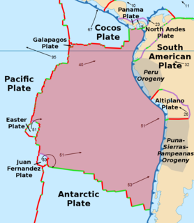
The Nazca Plate or Nasca Plate, named after the Nazca region of southern Peru, is an oceanic tectonic plate in the eastern Pacific Ocean basin off the west coast of South America. The ongoing subduction, along the Peru–Chile Trench, of the Nazca Plate under the South American Plate is largely responsible for the Andean orogeny. The Nazca Plate is bounded on the west by the Pacific Plate and to the south by the Antarctic Plate through the East Pacific Rise and the Chile Rise respectively. The movement of the Nazca Plate over several hotspots has created some volcanic islands as well as east-west running seamount chains that subduct under South America. Nazca is a relatively young plate both in terms of the age of its rocks and its existence as an independent plate having been formed from the break-up of the Farallon Plate about 23 million years ago. The oldest rocks of the plate are about 50 million years old.

Cocos Plate Young oceanic tectonic plate beneath the Pacific Ocean off the west coast of Central America

The Cocos Plate is a young oceanic tectonic plate beneath the Pacific Ocean off the west coast of Central America, named for Cocos Island, which rides upon it. The Cocos Plate was created approximately 23 million years ago when the Farallon Plate broke into two pieces, which also created the Nazca Plate. The Cocos Plate also broke into two pieces, creating the small Rivera Plate. The Cocos Plate is bounded by several different plates. To the northeast it is bounded by the North American Plate and the Caribbean Plate. To the west it is bounded by the Pacific Plate and to the south by the Nazca Plate.

East Pacific Rise A mid-oceanic ridge at a divergent tectonic plate boundary on the floor of the Pacific Ocean

The East Pacific Rise is a mid-ocean ridge, a divergent tectonic plate boundary located along the floor of the Pacific Ocean. It separates the Pacific Plate to the west from the North American Plate, the Rivera Plate, the Cocos Plate, the Nazca Plate, and the Antarctic Plate. It runs south from the Gulf of California in the Salton Sea basin in Southern California to a point near 55° S, 130° W, where it joins the Pacific-Antarctic Ridge trending west-southwest towards Antarctica, near New Zealand. Much of the rise lies about 3200 km (2000 mi) off the South American coast and rises about 1,800–2,700 m (6,000–9,000 ft) above the surrounding seafloor.

Triple junction Meeting point of three tectonic plates

A triple junction is the point where the boundaries of three tectonic plates meet. At the triple junction each of the three boundaries will be one of three types – a ridge (R), trench (T) or transform fault (F) – and triple junctions can be described according to the types of plate margin that meet at them. Of the ten possible types of triple junction only a few are stable through time. The meeting of four or more plates is also theoretically possible but junctions will only exist instantaneously.

Gorda Ridge Tectonic spreading center off the northern coast of California and southern Oregon

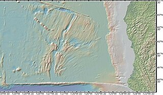
The Gorda Ridge, aka Gorda Ridges tectonic spreading center, is located roughly 200 kilometres (120 mi) off the northern coast of California and southern Oregon. Running NE – SW it is roughly 300 kilometres (190 mi) in length. The ridge is broken into three segments; the northern ridge, central ridge, and the southern ridge, which contains the Escanaba Trough.

Galápagos Microplate Very small tectonic plate at the Galapagos Triple Junction

The Galapagos Microplate (GMP) is a geological feature of the oceanic crust located at 1°50' N, offshore of the west coast of Colombia. The GMP is collocated with the Galapagos Triple Junction, which is an atypical ridge-ridge-ridge triple junction. At the Galapagos Triple Junction, the Pacific Plate, Cocos Plate, and Nazca Plate meet incompletely, forming two counter-rotating microplates at the junction of the Cocos-Nazca, Pacific-Cocos, and Pacific-Nazca spreading ridges.

Azores Triple Junction Tectonic plates intersection

The Azores Triple Junction (ATJ) is a geologic triple junction where the boundaries of three tectonic plates intersect: the North American Plate, the Eurasian Plate and the African Plate. This triple junction is located along the Mid-Atlantic Ridge (MAR) amidst the Azores islands, nearly due west of the Strait of Gibraltar. It is classed as an R-R-R triple junction of the T type, as it is an intersection of the Mid-Atlantic Ridge running north–south and the Terceira Rift which runs east-southeast.

Aden Ridge Part of an active oblique rift system in the Gulf of Aden, between Somalia and the Arabian Peninsula

The Aden Ridge is a part of an active oblique rift system located in the Gulf of Aden, between Somalia and the Arabian Peninsula to the north. The rift system marks the divergent boundary between the Somali and Arabian tectonic plates, extending from the Owen Transform Fault in the Arabian Sea to the Afar Triple Junction or Afar Plume beneath the Gulf of Tadjoura in Djibouti.

Galapagos Triple Junction Place where the boundaries of the Cocos Plate, the Nazca Plate, and the Pacific Plate meet

The Galapagos Triple Junction is a geological area in the eastern Pacific Ocean several hundred miles west of the Galapagos Islands where three tectonic plates - the Cocos Plate, the Nazca Plate and the Pacific Plate - meet. It is an unusual type of triple junction in which the three plates do not meet at a simple intersection. Instead, the junction includes two small microplates, the Galapagos Microplate and the Northern Galapagos Microplate, caught in the junction, turning synchronously with respect to each other and separated by the Hess Deep rift.

Pacific-Farallon Ridge Spreading ridge during the Late Cretaceous

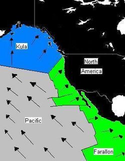
The Pacific-Farallon Ridge was a spreading ridge during the Late Cretaceous that extended 10,000 km in length and separated the Pacific Plate to the west and the Farallon Plate to the east. It ran south from the Pacific-Farallon-Kula triple junction at 51°N to the Pacific-Farallon-Antarctic triple junction at 43°S. As the Farallon Plate subducted obliquely under the North American Plate, the Pacific-Farallon Ridge approached and eventually made contact with the North American Plate about 30 million years ago. On average, this ridge had an equatorial spreading rate of 13.5 cm per year until its eventual collision with the North American Plate. In present day, the Pacific-Farallon Ridge no longer formally exists since the Farallon Plate has been broken up or subducted beneath the North American Plate, and the ridge has segmented, having been mostly subducted as well. The most notable remnant of the Pacific-Farallon Ridge is the 4000 km Pacific-Nazca segment of the East Pacific Rise.

Juan Fernández Plate Very small tectonic plate in the southern Pacific Ocean

The Juan Fernandez Plate is a microplate in the Pacific Ocean. With a surface area of approximately 105 km2, the microplate is located between 32° and 35°S and 109° and 112°W. The plate is located at a triple junction between the Pacific Plate, Antarctic Plate, and Nazca Plate. Approximately 2000 km to the west of South America, it is, on average, 3000 meters deep with its shallowest point coming to approximately 1600 meters, and its deepest point reaching 4400 meters.

Mariana Plate Small tectonic plate west of the Mariana Trench

The Mariana Plate is a micro tectonic plate located west of the Mariana Trench which forms the basement of the Mariana Islands which form part of the Izu–Bonin–Mariana Arc. It is separated from the Philippine Sea Plate to the west by a divergent boundary with numerous transform fault offsets. The boundary between the Mariana and the Pacific Plate to the east is a subduction zone with the Pacific Plate subducting beneath the Mariana. This eastern subduction is divided into the Mariana Trench, which forms the southeastern boundary, and the Izu–Ogasawara Trench the northeastern boundary. The subduction plate motion is responsible for the shape of the Mariana plate and back arc.

Panama Plate Small tectonic plate in Central America

The Panama Plate is a microplate; a small tectonic plate that exists between two actively spreading ridges and moves relatively independently of its surrounding plates. The Panama plate is located between the Cocos Plate and Nazca Plate to the south and the Caribbean Plate to the north. Most of its borders are convergent boundaries including a subduction zone to the west. It consists, for the most part, of the nations of Panama and Costa Rica.

This is a list of articles related to plate tectonics and tectonic plates.

Geology of the Pacific Ocean Overview about the geology of the Pacific Ocean

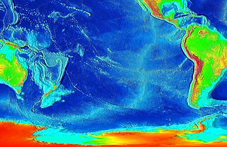
The Pacific Ocean evolved in the Mesozoic from the Panthalassic Ocean, which had formed when Rodinia rifted apart around 750 Ma. The first ocean floor which is part of the current Pacific Plate began 160 Ma to the west of the central Pacific and subsequently developed into the largest oceanic plate on Earth.

Lwandle Plate Mainly oceanic tectonic microplate off the southeast coast of Africa

The Lwandle Plate is one of three tectonic microplates, along with the Rovuma Plate and Victoria Plate, that make up the African Plate with the Somali Plate and the Nubian Plate. Its discovery is very recent, so the velocity of the plate is neither well known nor well understood. Many experiments are ongoing to quantify this. The Lwandle Plate lies between 30°E and 50°E, sharing a boundary with the Nubian, Somali, and Antarctic Plates.

Chile Ridge Submarine oceanic ridge in the Pacific Ocean

The Chile Ridge, also known as the Chile Rise, is a submarine oceanic ridge formed by the divergent plate boundary between the Nazca Plate and the Antarctic Plate. It extends from the triple junction of the Nazca, Pacific, and Antarctic plates to the Southern coast of Chile. The Chile Ridge is easy to recognize on the map, as the ridge is divided into several segmented fracture zones which are perpendicular to the ridge segments, showing an orthogonal shape toward the spreading direction. The total length of the ridge segments is about 550–600 km.

References

  1. 1 2 Naar, David; Hey, R. (May 10, 1991). "Tectonic Evolution of the Easter Microplate". Journal of Geophysical Research. 96 (B5): 7961–7993. Bibcode:1991JGR....96.7961N. doi:10.1029/90JB02398.
  2. 1 2 3 4 5 6 7 Rusby, Ruth; Searle, Roger (July 1995). "A History of Easter Microplate, 5.25 Ma to present". Journal of Geophysical Research. 100 (B7): 12617–12640. Bibcode:1995JGR...10012617R. doi:10.1029/94JB02779.
  3. Handschumacher, D. W. (1981). "Structure and evolution of the Easter Plate". Nazca Plate: Crustal Formation and Andean Convergence: A Volume Dedicated to George P. Woollard: 63.
  4. Alden, Andrew (Feb 28, 2017). "Here Are the Sizes of Tectonic or Lithospheric Plates". Thought Co.
  5. 1 2 3 4 5 6 7 8 9 10 11 Hey, R.; Naar, David (September 26, 1985). "Microplate Tectonics Along a Superfast Seafloor Spreading System near Easter Island". Nature. 317 (6035): 320–325. Bibcode:1985Natur.317..320H. doi:10.1038/317320a0.
  6. Anderson, Roger; Forsyth, Donald; Molnar, Peter; Mammerickx, Jacqueline (December 1974). "Fault plane solutions of earthquakes on the Nazca plate boundaries and the Easter plate". Earth and Planetary Science Letters. 24 (2): 188–202. Bibcode:1974E&PSL..24..188A. doi:10.1016/0012-821X(74)90096-X.
  7. Engeln, Joseph; Stein, Seth (May 1984). "Tectonics of the Easter plate". Earth and Planetary Science Letters. 68 (2): 259–270. Bibcode:1984E&PSL..68..259E. doi:10.1016/0012-821X(84)90158-4.
  8. 1 2 Neves, M. C.; Searle, R. C.; Bott, M. H. P. (October 2002). "Easter Microplate Dynamics". Journal of Geophysical Research. 108. Bibcode:2003JGRB..108.2213N. doi:10.1029/2001JB000908. hdl: 10400.1/11125 .