Geology of Chile

Last updated
Llaima volcano in eruption Llaima eruption2.jpg
Llaima volcano in eruption

The geology of Chile is a characterized by processes linked to subduction, such as volcanism, earthquakes, and orogeny. The building blocks of Chile's geology were assembled during the Paleozoic Era when Chile was the southwestern margin of the supercontinent Gondwana. In the Jurassic, Gondwana began to split, and the ongoing period of crustal deformation and mountain building known as the Andean orogeny began. In the Late Cenozoic, Chile definitely separated from Antarctica, and the Andes experienced a significant rise accompanied by a cooling climate and the onset of glaciations.

Contents

The subduction interactions shaped four main morphostructures of Chile: the Andes, the Intermediate Depression, the Coast Range, and the Peru–Chile Trench off the coast. Since Chile is on an active continental margin, it has many volcanoes. Almost the entire country is subject to earthquakes arising from strains in the Nazca and Antarctic Plates or shallow strike-slip faults. Northern Chilean mineral resources are a major economic resource, and the country is the leading producer of copper, lithium and molybdenum. Most of these mineral deposits were created from magmatic hydrothermal activity, and the water required to form those deposits derived from the subducted slab of the oceanic crust beneath the Andes.

The Chilean Easter Island and Juan Fernández Archipelago are volcanic hotspot islands in the eastward-moving Nazca plate. The geology of the Chilean Antarctic Territory has various commonalities with that of mainland Chile.

General characteristics

The three primary morphological features derived from the Andes are the Andes Mountains proper, the Chilean Coast Range and the Chilean Central Valley, also known as the Intermediate Depression and the Longitudinal Valley. The mountains run parallel in a north-south direction from Morro de Arica to Taitao Peninsula, making up most of Chile's land surface. South of Taitao, only the Andes Mountains are present.

North of the Taitao Peninsula, the Peru–Chile Trench subduction zone is the boundary between the South American and Nazca Plates. At Taitao, the Chile Triple Junction and the Nazca Plate subduct the South American Plate.

The Andes

The Andes are generally higher in northern Chile. Miscanti Lagoon near San Pedro de Atacama Chile Luca Galuzzi 2006.jpg
The Andes are generally higher in northern Chile.

In Norte Grande the mountains form a series of plateaus, such as Puna de Atacama and the Altiplano. At a south latitude of 27 degrees, Chile's highest mountain (Ojos del Salado) reaches a height of 6,893 metres (22,615 ft). Below 42 degrees south, the Andes split into a fjord landscape and the highest mountain is Monte San Valentin at 4,058 metres (13,314 ft) at north of Northern Patagonian Ice Field. As the mountains ebb, the snow line lowers; in the Llanquihue it is at 1,200 metres (3,900 ft), and 900 metres (3,000 ft) in the Magallanes.

Intermediate Depression

The Intermediate Depression, a series of faults running north to south, separates the Andes from the Coast Range with a steady decrease in altitude as the latitude increases. In Norte Grande the Intermediate Depression is partially covered by a series of salt flats, and has the world's largest potassium nitrate deposits. In Norte Chico, the depression disappears briefly before reappearing in a narrow valley at Santiago. From the narrows southward the valley widens until it is interrupted near Loncoche by the Bahía Mansa Metamorphic Complex (part of the Coast Range), then widening at Los Llanos (near Paillaco). In central and southern Chile (33°–42° south), the landscape is partially covered with glacial sediments from the Andes. In Zona Austral (south of 42° south) the depression dips below sea level, appearing occasionally in islands such as Chiloé. Its southern end is the Isthmus of Ofqui.

Chilean Coast Range

The Chilean Coast Range runs southward along the coast (parallel to the Andes) from Morro de Arica to Taitao Peninsula, ending at the Chile Triple Junction. The range, a combined horst, forearc high and accretionary wedge, was separated from the Andes during the Tertiary rise due to the subsidence of the Intermediate Depression.

Geologic history

Pangaea separation animation Pangea animation 03.gif
Pangaea separation animation
View of the Altiplano plateau in northern Chile Parinacota volcano.jpg
View of the Altiplano plateau in northern Chile
The mountains at Torres del Paine National Park have been heavily eroded by the Quaternary glaciations. Cuernos del Paine from Lake Pehoe.jpg
The mountains at Torres del Paine National Park have been heavily eroded by the Quaternary glaciations.
Retreat of the San Rafael Glacier from 1990 to 2000 San Rafael Glacier animation.gif
Retreat of the San Rafael Glacier from 1990 to 2000

Paleozoic Era

The oldest rocks in Chile are micaceous schists, phyllites, gneisses and quartzites, many examples of which are found in the Coast Range of south-central Chile. The schists of southern Chile were initially formed by sediment in the proto-Pacific Ocean, and later metamorphosed in the forearc wedge of the Peru–Chile Trench.

Mesozoic Era

During the Triassic Period about 250 million years ago Chile was part of the supercontinent Pangaea, which concentrated the world's major land masses. Africa, Antarctica, Australia and India were near Chile. When Pangaea began to split apart during the Jurassic period, South America and the adjacent land masses formed Gondwana. Floral affinities among these now-distant landmasses date from the Gondwanaland period. South America separated from Antarctica and Australia 27 million years ago with the development of the Drake Passage. Across the 1,000-kilometre (620 mi)-wide Drake Passage lie the mountains of the Antarctic Peninsula, south of the Scotia Plate, which appear to be a continuation of the Andes. In the extreme south, the Magallanes–Fagnano Fault separates Tierra del Fuego from the small Scotia Plate.

The formation of the Andes began during the Jurassic. During the Cretaceous, the Andes began to assume their present form by the uplifting, faulting and folding of sedimentary and metamorphic rocks of ancient cratons. Tectonic forces along the subduction zone along the west coast of South America continue to their orogenesis, resulting in earthquakes and volcanic eruptions to this day.

Cenozoic Era

The Altiplano plateau was formed during the Tertiary, with several mechanisms proposed; all attempt to explain why the topography of the Andes incorporates a large area of low relief at high altitude (high plateau):

  1. Existence of weaknesses in the Earth's crust prior to tectonic shortening. Such weaknesses would cause the partition of tectonic deformation and uplift into eastern and western cordillera, leaving the necessary space for the formation of the Altiplano basin.
  2. Magmatic processes rooted in the asthenosphere might have contributed to uplift the plateau.
  3. Climate controlled the spatial distribution of erosion and sediment deposition, creating the lubrication along the Nazca Plate subduction and hence influencing the transmission of tectonic forces into South America.
  4. Climate also determined the formation of internal drainage (endorheism) and sediment trapping within the Andes, potentially blocking tectonic deformation in the area between the two cordilleras.

Quaternary

The Quaternary glaciations left visible marks in most parts of Chile, particularly Zona Sur and Zona Austral. These include ice fields, fjords, glacial lakes and u-shaped valleys. During the Santa María glaciation glaciers extended into the Pacific Ocean at 42° south, dividing the Chilean Coast Range and creating what is now Chacao Channel. Chiloé, part of the Chilean Coast Range, became an island. South of Chacao Channel, Chile's coast is split by fjords, islands and channels; these glaciers created moraines at the edges of the Patagonian lakes, changing their outlets to the Pacific and shifting the continental divide. The remnants of the Patagonian Ice Sheet which covered large parts of Chile and Argentina are the Northern and the Southern Patagonian Ice Fields.

It has been suggested that from 1675 to 1850 the San Rafael Glacier advanced during the Little Ice Age. The first documented visit to the area was made in 1675 by the Spanish explorer Antonio de Vea, who entered San Rafael Lagoon through Río Témpanos ("Ice Floe River") without mentioning the many ice floes for which the river is named. De Vea also wrote that the San Rafael Glacier did not reach far into the lagoon. In 1766 another expedition noticed that the glacier did reach the lagoon and had calved into icebergs. Hans Steffen visited the area in 1898, noting that the glacier now penetrated far into the lagoon. As of 2001, the glacier has retreated behind its 1675 border due to climate change. [1]

Pacific islands

Most of the moai on Easter island are carved from volcanic tuff. Moai Rano raraku.jpg
Most of the moai on Easter island are carved from volcanic tuff.

Easter Island is a volcanic island consisting of three extinct volcanoes: Terevaka, at an altitude of 507 metres (1,663 ft), forms the bulk of the island. Two other volcanoes (Poike and Rano Kau) form the eastern and southern headlands, giving the island its triangular shape. There are numerous lesser cones and other volcanic features: the crater Rano Raraku, the cinder cone Puna Pau and many volcanic caves (including lava tubes).

Easter Island and its surrounding islets, including Motu Nui and Motu Iti, form the comminuted apex of a large volcanic mountain rising over 2,000 metres (6,600 ft) from the seabed. It is part of the Sala y Gómez Ridge, a mostly-submarine mountain range with dozens of seamounts. Pukao and Moai are two seamounts west of Easter Island, extending 2,700 km (1,700 mi) east to the Nazca Seamount. Pukao, Moai and Easter Island were formed during the last 750,000 years, with the last eruption a little over 100,000 years ago. These are the youngest mountains of the Sala y Gómez Ridge, which was formed by the Nazca Plate floating over the Easter hotspot. [2] Only on Easter Island is the Sala y Gómez Ridge dry land.

The volcanic Juan Fernández Islands were created by a hotspot in the Earth's mantle penetrating the Nazca Plate. The islands were carried eastward as the plate subducted the South American continent. Radiometric dating indicates that Santa Clara is the oldest of the islands (at 5.8 million years), followed by Robinson Crusoe (3.8–4.2 million years) and Alexander Selkirk (1.0–2.4 million years). Robinson Crusoe is the largest of the islands at 93 square kilometres (36 sq mi), and its highest peak (El Yunque) is 916 metres (3,005 ft) high. Alexander Selkirk covers 50 square kilometres (19 sq mi), and its highest peak is Los Innocentes at 1,319 metres (4,327 ft). Santa Clara covers 2.2 square kilometres (540 acres), reaching an elevation of 350 metres (1,150 ft).

Economic geology

Mining

Chuquicamata copper mine in 1984 Chuqui001 02.jpg
Chuquicamata copper mine in 1984

Chile has the world's largest copper reserves, and is the largest producer and exporter of the metal. [3] Notable copper mines include Chuquicamata and Escondida. Chile accounts for five percent of the Western Hemisphere's gold production, of which 41 percent is a by-product of copper extraction. [3] The country holds the largest world reserves of rhenium [3] and potassium nitrate, and its reserves of molybdenum are estimated to be the third-largest in the world. [3] Most of Chile's mineral resources are in the north; gas, coal and oil reserves, in the southern Magallanes Region, are sufficient for local needs. Guarello Island, in the Magallanes Region, has the world's southernmost limestone mine.

Geothermal energy

Since 2000, geothermal exploration and concessions have been regulated by the Law of Geothermal Concessions (Spanish : Ley de Concesiones de Energía Geotérmica). The Chilean company Geotermia del Pacífico, with support from CORFO, is exploring a location in Curacautín as a site for a geothermal power plant. Geotermia del Paícifco's studies indicated that two geothermal fields near Curacautín could be used for energy production, with a combined capacity to supply 36,000 homes in 2010. One area to be developed is located near the Tolhuaca hot springs, and the other is in Río Blanco Springs. [4] Another area under consideration for geothermal production is Cordón Caulle.

Tourism

Although geology-focused tourism is rare, there are some sites in which the local geology is a major attraction (for example, the copper mine at Chuquicamata).

Geological hazards

Map of Valparaiso after the earthquake of 16 August 1906

.mw-parser-output .legend{page-break-inside:avoid;break-inside:avoid-column}.mw-parser-output .legend-color{display:inline-block;min-width:1.25em;height:1.25em;line-height:1.25;margin:1px 0;text-align:center;border:1px solid black;background-color:transparent;color:black}.mw-parser-output .legend-text{}
Area of the city most affected by earthquake

City blocks most damaged by fire Plano de Valparaiso-Terremoto 1906.jpg
Map of Valparaíso after the earthquake of 16 August 1906
  Area of the city most affected by earthquake
  City blocks most damaged by fire

Earthquakes, volcanic eruptions and mass ground movements are frequent occurrences. The subduction zone along Chile's coast has produced the most powerful earthquake ever recorded, the 1960 Valdivia earthquake. Earthquakes are notorious for triggering volcanic eruptions, such as the 1960 Cordón Caulle eruption. Chilean earthquakes have produced tsunamis.

Landslides occur frequently in the Andes, most following earthquakes. The 2007 Aysén Fjord earthquakes produced several landslides along the Fjords Mountains, spawning a tsunami. Lahars are among the most lethal volcanic hazards in Chile; a lahar destroyed the original site of Coñaripe.

Earthquakes

Major earthquakes in Chile occur in a small number of source areas. Those affecting coastal regions are generally aligned offshore from Concepción southward, with the major epicenters producing a predictable pattern of seismic and tsunami effects. [5] The first systematic seismological recordings in Chile began after an earthquake and fire devastated Valparaiso in 1906. [6]

Earthquakes in northern Chile are known to have caused both uplift and subsidence of the continent. Large earthquakes of Magnitude 8 or more are associated with subsidence and drowning of the Chilean coast, except peninsulas and offshore islands. Magnitude 7 to 8 earthquakes with a source area near an internal boundary of the Earth known as the Moho are known to result in uplift of the coast. Earthquakes near the Moho may account for permanent deformation of the western edge of South American plate that accumulates into a long-term net uplift of the continent. [7]

Quake clusters

Although the most powerful six quakes recorded were clustered in two time periods (a 12-year span from 1952 to 1964 and a seven-year span from 2004 to 2011), this is considered a statistical anomaly. [8] The phenomenon of comparably-large quakes on the same (or neighboring) faults within months of each other may be explained by geological mechanisms, but this does not fully demonstrate a relationship between events separated by longer periods and greater distances [9]

See also

Notes

  1. Araneda, Alberto; Torrejón, Fernando; Aguayo, Mauricio; Torres, Laura; Cruces, Fabiola; Cisternas, Marco; Urrutia, Roberto (November 2007). "Historical records of San Rafael glacier advances (North Patagonian Icefield): another clue to 'Little Ice Age' timing in southern Chile?". The Holocene. 17 (7): 987–998. Bibcode:2007Holoc..17..987A. doi:10.1177/0959683607082414. hdl: 10533/178477 . S2CID   128826804.
  2. Haase, Karsten & Stoffers, P & Garbe-Schönberg, Dieter. (1997). The Petrogenetic Evolution of Lavas from Easter Island and Neighbouring Seamounts, Near-ridge Hotspot Volcanoes in the SE Pacific. Journal of Petrology - J PETROL. 38. 785–813. doi : 10.1093/petrology/38.6.785.
  3. 1 2 3 4 U.S. Geological Survey (2005). Minerals Yearbook 2005.
  4. "Chile Could Have Geothermal Energy By 2010". Santiago Times
  5. Lomnitz, Cinna; "Major earthquakes and tsunamis in Chile during the period 1535 to 1955"; International Journal of Earth Sciences , Vol. 59, No. 3; abstract.
  6. Moreno, Teresa. (2006). The Geology of Chile, p. 264. , p. 264, at Google Books
  7. Melnick, Daniel (2016). "Rise of the central Andean coast by earthquakes straddling the Moho". Nature Geoscience. 9 (5): 401–408. Bibcode:2016NatGe...9..401M. doi:10.1038/NGEO2683.
  8. Pappas, Stephanie. "Sumatra, Japan, Chile: Are Earthquakes Getting Worse?"; LiveScience ; 11 March 2011.
  9. Brahic, Catherine; "The mega-quake connection: Are huge earthquakes linked?"; New Scientist ; UK; 16 March 2011.

Related Research Articles

<span class="mw-page-title-main">Andes</span> Mountain range in South America

The Andes, Andes Mountains or Andean Mountain Range are the longest continental mountain range in the world, forming a continuous highland along the western edge of South America. The range is 8,900 km (5,530 mi) long, 200 to 700 km wide, and has an average height of about 4,000 m (13,123 ft). The Andes extend from north to south through seven South American countries: Venezuela, Colombia, Ecuador, Peru, Bolivia, Chile and Argentina.

<span class="mw-page-title-main">Ring of Fire</span> Region around the rim of the Pacific Ocean where many volcanic eruptions and earthquakes occur

The Ring of Fire is a region around much of the rim of the Pacific Ocean where many volcanic eruptions and earthquakes occur. The Ring of Fire is a horseshoe-shaped belt about 40,000 km (25,000 mi) long and up to about 500 km (310 mi) wide.

<span class="mw-page-title-main">Nazca Plate</span> Oceanic tectonic plate in the eastern Pacific Ocean basin

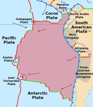
The Nazca Plate or Nasca Plate, named after the Nazca region of southern Peru, is an oceanic tectonic plate in the eastern Pacific Ocean basin off the west coast of South America. The ongoing subduction, along the Peru–Chile Trench, of the Nazca Plate under the South American Plate is largely responsible for the Andean orogeny. The Nazca Plate is bounded on the west by the Pacific Plate and to the south by the Antarctic Plate through the East Pacific Rise and the Chile Rise respectively. The movement of the Nazca Plate over several hotspots has created some volcanic islands as well as east–west running seamount chains that subduct under South America. Nazca is a relatively young plate both in terms of the age of its rocks and its existence as an independent plate having been formed from the break-up of the Farallon Plate about 23 million years ago. The oldest rocks of the plate are about 50 million years old.

<span class="mw-page-title-main">Antarctic Plate</span> Major tectonic plate containing Antarctica and the surrounding ocean floor

The Antarctic Plate is a tectonic plate containing the continent of Antarctica, the Kerguelen Plateau, and some remote islands in the Southern Ocean and other surrounding oceans. After breakup from Gondwana, the Antarctic plate began moving the continent of Antarctica south to its present isolated location, causing the continent to develop a much colder climate. The Antarctic Plate is bounded almost entirely by extensional mid-ocean ridge systems. The adjoining plates are the Nazca Plate, the South American Plate, the African Plate, the Somali Plate, the Indo-Australian Plate, the Pacific Plate, and, across a transform boundary, the Scotia Plate.

<span class="mw-page-title-main">Ojos del Salado</span> Highest volcano in the world

Nevado Ojos del Salado is a dormant complex volcano in the Andes on the Argentina–Chile border. It is the highest volcano on Earth and the highest peak in Chile. The upper reaches of Ojos del Salado consist of several overlapping lava domes, lava flows and volcanic craters, with an only sparse ice cover. The complex extends over an area of 70–160 square kilometres (27–62 sq mi) and its highest summit reaches an altitude of 6,893 metres (22,615 ft) above sea level. Numerous other volcanoes rise around Ojos del Salado.

Viedma is a subglacial volcano whose existence is questionable. It is supposedly located below the ice of the Southern Patagonian Ice Field, an area disputed between Argentina and Chile. The 1988 eruption deposited ash and pumice on the ice field and produced a mudflow that reached Viedma Lake. The exact position of the edifice is unclear, both owing to the ice cover and because the candidate position, the "Viedma Nunatak", does not clearly appear to be of volcanic nature.

Mentolat is an ice-filled, 6 km (4 mi) wide caldera in the central portion of Magdalena Island, Aisén Province, Chilean Patagonia. This caldera sits on top of a stratovolcano which has generated lava flows and pyroclastic flows. The caldera is filled with a glacier.

<span class="mw-page-title-main">Cerro Macá</span> Mountain in Chile

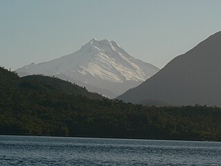
Cerro Macá is a stratovolcano located to the north of the Aisén Fjord and to the east of the Moraleda Channel, in the Aysén del General Carlos Ibáñez del Campo Region of Chile. This glacier-covered volcano lies along the regional Liquiñe-Ofqui Fault Zone.

<span class="mw-page-title-main">Geology of the Pacific Northwest</span> Geology of Oregon and Washington (United States) and British Columbia (Canada)

The geology of the Pacific Northwest includes the composition, structure, physical properties and the processes that shape the Pacific Northwest region of North America. The region is part of the Ring of Fire: the subduction of the Pacific and Farallon Plates under the North American Plate is responsible for many of the area's scenic features as well as some of its hazards, such as volcanoes, earthquakes, and landslides.

<span class="mw-page-title-main">Natural regions of Chile</span> Broad range of ecosystems and climates in the South American country

Because Chile extends from a point about 625 kilometers north of the Tropic of Capricorn to a point hardly more than 1,400 kilometers north of the Antarctic Circle, within its territory can be found a broad selection of the Earth's climates.

<span class="mw-page-title-main">Andean Volcanic Belt</span> Volcanic belt in South America

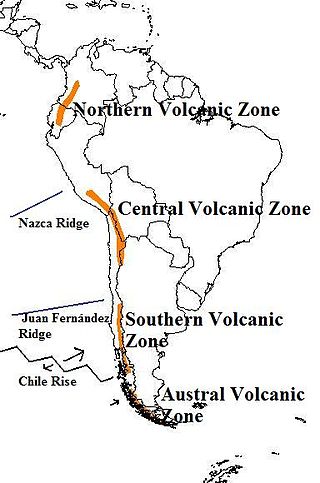
The Andean Volcanic Belt is a major volcanic belt along the Andean cordillera in Argentina, Bolivia, Chile, Colombia, Ecuador, and Peru. It is formed as a result of subduction of the Nazca Plate and Antarctic Plate underneath the South American Plate. The belt is subdivided into four main volcanic zones which are separated by volcanic gaps. The volcanoes of the belt are diverse in terms of activity style, products, and morphology. While some differences can be explained by which volcanic zone a volcano belongs to, there are significant differences within volcanic zones and even between neighboring volcanoes. Despite being a type location for calc-alkalic and subduction volcanism, the Andean Volcanic Belt has a broad range of volcano-tectonic settings, as it has rift systems and extensional zones, transpressional faults, subduction of mid-ocean ridges and seamount chains as well as a large range of crustal thicknesses and magma ascent paths and different amounts of crustal assimilations.

<span class="mw-page-title-main">Chile Triple Junction</span> Place where the South American, Nazca and Antarctic tectonic plates meet

The Chile Triple Junction is a geologic triple junction located on the seafloor of the Pacific Ocean off Taitao and Tres Montes Peninsula on the southern coast of Chile. Here three tectonic plates meet: the South American Plate, the Nazca Plate and the Antarctic Plate. This triple junction is unusual in that it consists of a mid-oceanic ridge, the Chile Rise, being subducted under the South American Plate at the Peru–Chile Trench. The Chile Triple Junction is the boundary between the Chilean Rise and the Chilean margin, where the Nazca, Antarctic, and South American plates meet at the trench.

<span class="mw-page-title-main">Nazca Ridge</span> Submarine ridge off the coast of Peru

The Nazca Ridge is a submarine ridge, located on the Nazca Plate off the west coast of South America. This plate and ridge are currently subducting under the South American Plate at a convergent boundary known as the Peru-Chile Trench at approximately 7.7 cm (3.0 in) per year. The Nazca Ridge began subducting obliquely to the collision margin at 11°S, approximately 11.2 Ma, and the current subduction location is 15°S. The ridge is composed of abnormally thick basaltic ocean crust, averaging 18 ±3 km thick. This crust is buoyant, resulting in flat slab subduction under Peru. This flat slab subduction has been associated with the uplift of Pisco Basin and the cessation of Andes volcanism and the uplift of the Fitzcarrald Arch on the South American continent approximately 4 Ma.

<span class="mw-page-title-main">Andean orogeny</span> Ongoing mountain-forming process in South America

The Andean orogeny is an ongoing process of orogeny that began in the Early Jurassic and is responsible for the rise of the Andes mountains. The orogeny is driven by a reactivation of a long-lived subduction system along the western margin of South America. On a continental scale the Cretaceous and Oligocene were periods of re-arrangements in the orogeny. The details of the orogeny vary depending on the segment and the geological period considered.

Aguas Calientes is a major Miocene caldera in Salta Province, Argentina. It is in the Central Volcanic Zone of the Andes, a zone of volcanism covering southern Peru, Bolivia, northwest Argentina and northern Chile. This zone contains stratovolcanoes and calderas.

Jotabeche is a Miocene-Pliocene caldera in the Atacama Region of Chile. It is part of the volcanic Andes, more specifically of the extreme southern end of the Central Volcanic Zone (CVZ). This sector of the Andean Volcanic Belt contains about 44 volcanic centres and numerous more minor volcanic systems, as well as some caldera and ignimbrite systems. Jotabeche is located in a now inactive segment of the CVZ, the Maricunga Belt.

Fueguino is a volcanic field in Chile. The southernmost volcano in the Andes, it lies on Tierra del Fuego's Cook Island and also extends over nearby Londonderry Island. The field is formed by lava domes, pyroclastic cones, and a crater lake.

Wheelwright caldera is a caldera in Chile. It is variously described as being between 11 kilometres (6.8 mi) and 22 kilometres (14 mi) wide and lies in the Central Volcanic Zone of the Andes. A lake lies within the caldera, which is among the largest of the Central Andes. The caldera lies in the region of Ojos del Salado, the world's tallest volcano.

<span class="mw-page-title-main">Sillajhuay</span> Volcano in Bolivia and Chile

Sillajhuay is a volcano on the border between Bolivia and Chile. It is part of a volcanic chain that stretches across the border between Bolivia and Chile and forms a mountain massif that is in part covered by ice; whether this ice should be considered a glacier is debatable but it has been retreating in recent decades.

<span class="mw-page-title-main">Chile Ridge</span> Submarine oceanic ridge in the Pacific Ocean

The Chile Ridge, also known as the Chile Rise, is a submarine oceanic ridge formed by the divergent plate boundary between the Nazca Plate and the Antarctic Plate. It extends from the triple junction of the Nazca, Pacific, and Antarctic plates to the Southern coast of Chile. The Chile Ridge is easy to recognize on the map, as the ridge is divided into several segmented fracture zones which are perpendicular to the ridge segments, showing an orthogonal shape toward the spreading direction. The total length of the ridge segments is about 550–600 km.

References