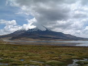
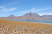
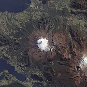
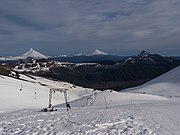
Name Landform type Elevation (m) Last eruption Coordinates Other names OVDAS surveillance Tacora stratovolcano 5,980 Upper-Pleistocene 17°43′S 69°46′W / 17.72°S 69.77°W / -17.72; -69.77 (Tacora ) Carrizalillo (caldera) Caldera Cretaceous –Paleogene Potrerillos (caldera) Caldera Cretaceous –Paleogene Lexone [3] Lava dome 5,340 Holocene 17°52′S 69°29′W / 17.87°S 69.48°W / -17.87; -69.48 (Lexone ) Choquelimpie Stratovolcano Miocene 18°18′19″S 69°16′42″W / 18.30528°S 69.27833°W / -18.30528; -69.27833 (Choquelimpie ) Lauca (volcano) Stratovolcano 5,140 Pliocene 18°20′S 69°23′W / 18.333°S 69.383°W / -18.333; -69.383 (Lauca volcano ) Caldera Lauca Caldera Miocene El Rojo Norte Cinder cone Pliocene 18°28′S 69°12′W / 18.467°S 69.200°W / -18.467; -69.200 (El Rojo Norte ) Cerro Napa Stratovolcano Pleistocene 20°30′S 68°40′W / 20.500°S 68.667°W / -20.500; -68.667 (Cerro Napa ) El Rojo Sur Cinder cone Pliocene 20°50′S 68°37′W / 20.833°S 68.617°W / -20.833; -68.617 (El Rojo Sur ) Porunita Cinder cone 3.5 million years ago 20°50′35.1″S 68°36′49.5″W / 20.843083°S 68.613750°W / -20.843083; -68.613750 (Porunita ) Pabellón de Inca Stratovolcano 20°55′S 68°37′W / 20.917°S 68.617°W / -20.917; -68.617 (Pabellón de Inca ) Cerro Cebollar 5,716 A few million years 21°37′S 68°28′W / 21.617°S 68.467°W / -21.617; -68.467 (Chillahuita ) Cerro Chela Stratovolcano 5,644 Pliocene 21°24′S 68°30′W / 21.400°S 68.500°W / -21.400; -68.500 (Cerro Chela ) Cerro de las Cuevas Stratovolcano 5,294 3.15±0.15 million years ago 21°35′S 68°29′W / 21.583°S 68.483°W / -21.583; -68.483 (Cerro de las Cuevas ) Cerro Chanka Lava dome Pleistocene 21°47′09″S 68°18′37″W / 21.78583°S 68.31028°W / -21.78583; -68.31028 (Cerro Chanka ) Cerros Bravos-Barros Negros Volcanic complex 26-22 million years ago 26°38′S 69°15′W / 26.633°S 69.250°W / -26.633; -69.250 (Cerros Bravos-Barros Negros ) Chillahuita Lava dome 22°10′S 68°02′W / 22.167°S 68.033°W / -22.167; -68.033 (Chillahuita ) Chusmiza Stratovolcano Miocene Taapaca stratovolcano 5,860 320 BC ± 50 years 18°06′S 69°30′W / 18.10°S 69.50°W / -18.10; -69.50 (Taapaca (volcano) ) Corral de Coquena maar , spatter rampart 4,572 Pliocene 23°26′S 67°28′W / 23.433°S 67.467°W / -23.433; -67.467 (Corral de Coquena ) Cerro Alconcha stratovolcano more than 9.3 million years ago 21°04′S 68°32′W / 21.067°S 68.533°W / -21.067; -68.533 (Cerro Alconcha ) Apacheta-Aguilucho volcanic complex Two volcanoes 5,581 50,000 years ago 21°50′S 68°10′W / 21.833°S 68.167°W / -21.833; -68.167 (Apacheta-Aguilucho volcanic complex ) Parinacota stratovolcano 6,348 Holocene 18°10′S 69°09′W / 18.17°S 69.15°W / -18.17; -69.15 ("Parinacota (volcano)" ) Cerro Cariquima stratovolcano 5,365 Pleistocene 19°33′S 68°41′W / 19.55°S 68.68°W / -19.55; -68.68 ("Cerro Cariquima" ) Acotango stratovolcano 6,052 Holocene 18°22′S 69°03′W / 18.37°S 69.05°W / -18.37; -69.05 ("Acotango" ) Wallatiri stratovolcano 6,071 1960 18°25′S 69°10′W / 18.42°S 69.17°W / -18.42; -69.17 ("Guallatiri" ) Arintika stratovolcano 5,597 Holocene 18°44′S 69°03′W / 18.73°S 69.05°W / -18.73; -69.05 ("Arintica" ) Isluga stratovolcano 5,550 1913 19°09′S 68°50′W / 19.15°S 68.83°W / -19.15; -68.83 ("Isluga" ) Puchuldiza [4] 4,500 Pleistocene 19°25′S 68°58′W / 19.42°S 68.97°W / -19.42; -68.97 ("Puchuldiza" ) Cerro Pina [5] 4,037 Holocene 19°29′S 68°39′W / 19.49°S 68.65°W / -19.49; -68.65 ("Cerro Pina" ) Tatajachura stratovolcano 5,240 6 ± 1.3 million years ago 19°30′S 69°07′W / 19.5°S 69.12°W / -19.5; -69.12 ("Tatajachura" ) Iru Phutunqu stratovolcano 5,163 1995 20°44′S 68°33′W / 20.73°S 68.55°W / -20.73; -68.55 ("Irruputuncu" ) Millunu stratovolcano Miocene Guaichane-Mamuta Volcanic complex 4,684 Miocene Cerro Ascotan stratovolcano 5,500 1995 21°41′S 68°07′W / 21.683°S 68.117°W / -21.683; -68.117 (Cerro Ascotan ) Unnamed 4,800 Holocene 20°50′S 68°38′W / 20.83°S 68.63°W / -20.83; -68.63 ("Unnamed" ) Olca-Paruma stratovolcano 5,407 1867 20°56′S 68°29′W / 20.93°S 68.48°W / -20.93; -68.48 ("Olca-Paruma" ) Aucanquilcha stratovolcano 6,176 Holocene 21°13′S 68°28′W / 21.22°S 68.47°W / -21.22; -68.47 ("Aucanquilcha" ) Ollagüe stratovolcano 5,868 21°18′S 68°11′W / 21.30°S 68.18°W / -21.30; -68.18 ("Ollagüe" ) Cerro del Azufre stratovolcano 5,846 Holocene 21°47′S 68°14′W / 21.78°S 68.23°W / -21.78; -68.23 ("Cerro del Azufre" ) San Pedro stratovolcano 6,145 1960 21°53′S 68°24′W / 21.88°S 68.40°W / -21.88; -68.40 ("San Pedro (Chile volcano)" ) Paniri stratovolcano 5,946 22°05′S 68°15′W / 22.08°S 68.25°W / -22.08; -68.25 ("Cerro Paniri" ) Cerro del León stratovolcano 5,760 22°11′S 68°07′W / 22.18°S 68.12°W / -22.18; -68.12 ("Cerro del León" ) Linzor stratovolcano 5,680 22°11′S 67°57′W / 22.18°S 67.95°W / -22.18; -67.95 ("Linzor" ) Cerro Toconce [6] 5,435 Holocene 22°12′S 68°06′W / 22.20°S 68.10°W / -22.20; -68.10 ("Cerro Toconce" ) Cerro Deslinde 5,606 22°16′26″S 67°56′10″W / 22.27389°S 67.93611°W / -22.27389; -67.93611 ("Cerro Deslinde" ) El Volcán [ citation needed ] 5,100 22°20′S 67°58′W / 22.33°S 67.97°W / -22.33; -67.97 ("El Volcán" ) El Tatio [7] 4,280 Pleistocene 22°21′S 68°02′W / 22.35°S 68.03°W / -22.35; -68.03 ("El Tatio (volcano)" ) Tocorpuri (La Torta) stratovolcano 5,018 22°30′S 67°54′W / 22.50°S 67.90°W / -22.50; -67.90 ("Cerros de Tocorpuri" ) Putana stratovolcano 5,890 1810 ± 10 years 22°34′S 67°52′W / 22.57°S 67.87°W / -22.57; -67.87 ("Putana Volcano" ) Chaxas lava dome 1.09±0.56 mya 22°45′S 68°00′W / 22.750°S 68.000°W / -22.750; -68.000 ("Chaxas" ) Sairecabur stratovolcano 5,971 Holocene 22°44′S 67°53′W / 22.74°S 67.88°W / -22.74; -67.88 ("Sairecabur" ) Licancabur stratovolcano 5,916 Holocene 22°50′S 67°53′W / 22.83°S 67.88°W / -22.83; -67.88 ("Licancabur" ) Guayaques Lava domes 5,598 Holocene 22°53′S 67°35′W / 22.88°S 67.58°W / -22.88; -67.58 ("Guayaques" ) Purico Complex Pyroclastic shield , Volcanic complex 5,703 Holocene 23°00′S 67°45′W / 23.00°S 67.75°W / -23.00; -67.75 ("Purico Complex" ) Alitar Stratovolcano 5,346 Holocene 23°09′S 67°38′W / 23.150°S 67.633°W / -23.150; -67.633 ("Alitar" ) Acamarachi stratovolcano 6,046 23°11′S 67°22′W / 23.18°S 67.37°W / -23.18; -67.37 ("Acamarachi" ) Pili Colachi stratovolcano 5,631 Holocene 23°14′S 67°39′W / 23.23°S 67.65°W / -23.23; -67.65 ("Colachi" ) Laguna Verde stratovolcano 5,412 Holocene? 23°15′S 67°43′W / 23.25°S 67.71°W / -23.25; -67.71 ("Laguna Verde (volcano)" ) Cerro Overo maar 4,555 Holocene 23°21′S 67°40′W / 23.35°S 67.67°W / -23.35; -67.67 ("Cerro Overo" ) Tumisa Lava domes 5,658 500,000 years ago 23°28′S 67°49′W / 23.467°S 67.817°W / -23.467; -67.817 ("Tumisa" ) Aguas Calientes stratovolcano 5,924 23°22′S 67°41′W / 23.37°S 67.68°W / -23.37; -67.68 ("Aguas Calientes (volcano)" ) Lascar stratovolcano 5,592 2015 23°22′S 67°44′W / 23.37°S 67.73°W / -23.37; -67.73 ("Lascar (volcano)" ) Chiliques stratovolcano 5,778 Unknown 23°35′S 67°42′W / 23.58°S 67.70°W / -23.58; -67.70 ("Chiliques" ) Cordón de Puntas Negras stratovolcano 5,852 Holocene 23°45′S 67°32′W / 23.75°S 67.53°W / -23.75; -67.53 ("Cordón de Puntas Negras" ) Miñiques stratovolcano 5,910 23°49′S 67°46′W / 23.82°S 67.77°W / -23.82; -67.77 ("Miñiques" ) Cerro Tujle [8] 3,550 Holocene 23°50′S 67°57′W / 23.83°S 67.95°W / -23.83; -67.95 ("Cerro Tujle" ) El Laco Volcanic group 5,325 or 5,472 Pleistocene 23°50′29.6″S 67°29′24.6″W / 23.841556°S 67.490167°W / -23.841556; -67.490167 ("El Laco" ) Cordón Chalviri stratovolcano 5,623 Holocene 23°51′S 67°37′W / 23.85°S 67.62°W / -23.85; -67.62 ("Cordón de Puntas Negras" ) Caichinque stratovolcano 4,450 23°57′S 67°44′W / 23.95°S 67.73°W / -23.95; -67.73 ("Caichinque" ) Tilocalar [9] stratovolcano 3,116 23°58′S 68°08′W / 23.97°S 68.13°W / -23.97; -68.13 ("Tilocalar" ) Pular stratovolcano 6,233 Unknown 24°11′S 68°03′W / 24.18°S 68.05°W / -24.18; -68.05 ("Pular (volcano)" ) El Negrillar [10] pyroclastic cone 3,500 24°11′S 68°15′W / 24.18°S 68.25°W / -24.18; -68.25 ("El Negrillar" ) See also Negrillar de Ensenada at the Osorno (volcano) La Negrillar [11] pyroclastic cone 4,109 24°17′S 68°36′W / 24.28°S 68.60°W / -24.28; -68.60 ("La Negrillar" ) See also Negrillar de Ensenada at the Osorno (volcano) Socompa stratovolcano 6,051 5250 BC (?) 24°24′S 68°15′W / 24.40°S 68.25°W / -24.40; -68.25 ("Socompa (volcano)" ) Llullaillaco stratovolcano 6,739 1877 24°43′S 68°30′W / 24.72°S 68.50°W / -24.72; -68.50 ("Llullaillaco" ) Volcan de la Pena stratovolcano 5,247 12 million years ago 25°4.37′S 68°42.72′W / 25.07283°S 68.71200°W / -25.07283; -68.71200 ("Volcan de la Pena" ) Cerro Escorial stratovolcano 5,447 Holocene 25°05′S 68°22′W / 25.08°S 68.37°W / -25.08; -68.37 ("Cerro Escorial" ) Lastarria stratovolcano 5,697 Holocene 25°10′S 68°30′W / 25.17°S 68.50°W / -25.17; -68.50 ("Lastarria (volcano)" ) Chaco volcano 5,045 or 5,145 Miocene 25°27′S 69°02′W / 25.450°S 69.033°W / -25.450; -69.033 ("Chaco (volcano)" ) Cordón del Azufre stratovolcano 5,463 Holocene 25°20′S 68°31′W / 25.33°S 68.52°W / -25.33; -68.52 ("Cordón del Azufre" ) Cerro Bayo complex volcano 5,401 Holocene 25°25′S 68°35′W / 25.42°S 68.58°W / -25.42; -68.58 ("Cerro Bayo Complex" ) Dos Crateres Twin volcano 7.9±0.5 Ma 25°36′S 68°36′W / 25.600°S 68.600°W / -25.600; -68.600 ("Dos Crateres" ) Sierra de Gorbea Lava field 4.7±0.5 Ma and 5.2±0.5 Ma 25°44′S 68°45′W / 25.733°S 68.750°W / -25.733; -68.750 ("Sierra de Gorbea" ) Juan de la Vega maar 25°52′S 68°48′W / 25.867°S 68.800°W / -25.867; -68.800 ("Juan de la Vega" ) Chato Aislado Caldera and lava dome 1.2 Ma 25°59′S 68°49′W / 25.98°S 68.81°W / -25.98; -68.81 ("Chato Aislado" ) Dos Puntas Volcano 2 Ma 25°58′S 68°27′W / 25.967°S 68.450°W / -25.967; -68.450 ("Dos Puntas" ) Leon Muerto 4799 19,900,000 ± 800,000 years ago 25°57′S 68°28′W / 25.950°S 68.467°W / -25.950; -68.467 ("Leon Muerto" ) Salar Grande Caldera Miocene 26°00′S 68°40′W / 26.000°S 68.667°W / -26.000; -68.667 ("Salar Grande (caldera)" ) Doña Ines Stratovolcano 5075 Miocene 26°04′40″S 69°11′06″W / 26.07778°S 69.18500°W / -26.07778; -69.18500 ("Doña Ines" ) Los Colorados Caldera Miocene 26°05′S 68°19′W / 26.09°S 68.32°W / -26.09; -68.32 ("Los Colorados (caldera)" ) El Salvador Paleocene-Eocene 26°17′30″S 69°32′30″W / 26.29167°S 69.54167°W / -26.29167; -69.54167 ("El Salvador (caldera)" ) San Felix [12] Shield volcano 183 Holocene 26°16′S 80°07′W / 26.27°S 80.12°W / -26.27; -80.12 ("San Felix (volcano)" ) Sierra Nevada de Lagunas Bravas stratovolcano 6,127 26°29′S 68°34′W / 26.48°S 68.57°W / -26.48; -68.57 ("Sierra Nevada de Lagunas Bravas" ) Wheelwright caldera caldera Pliocene 26°45′00″S 68°37′30″W / 26.75000°S 68.62500°W / -26.75000; -68.62500 ("Wheelwright caldera" ) Falso Azufre stratovolcano 5,890 Holocene 26°48′S 68°22′W / 26.80°S 68.37°W / -26.80; -68.37 ("Falso Azufre" ) Pukao submarine volcano 26°57′S 110°16′W / 26.95°S 110.27°W / -26.95; -110.27 ("Pukao (seamount)" ) Ojos de Maricunga stratovolcano and caldera 4,985 middle Miocene 27°00′S 69°13′W / 27.000°S 69.217°W / -27.000; -69.217 ("Ojos de Maricunga" ) Incahuasi stratovolcano and caldera 6,621 27°02′S 68°17′W / 27.04°S 68.28°W / -27.04; -68.28 ("Incahuasi" ) El Solo stratovolcano 6,190 27°07′S 68°43′W / 27.11°S 68.72°W / -27.11; -68.72 ("El Solo" ) Pastillito volcanic chain 4,883 Middle Miocene Ojos del Salado stratovolcano 6,891 700 AD ± 300 27°07′S 68°32′W / 27.12°S 68.53°W / -27.12; -68.53 ("Ojos del Salado" ) Poike , Easter Island shield volcano 370 >1Ma 27°09′S 109°23′W / 27.15°S 109.38°W / -27.15; -109.38 ("Poike, Easter Island" ) Porquesa Lava dome 4,600 Pliocene/Pleistocene 19°59′S 68°46′W / 19.983°S 68.767°W / -19.983; -68.767 ("Porquesa" ) Rano Kau , Easter Island crater lake 250 >1Ma 27°09′S 109°23′W / 27.15°S 109.38°W / -27.15; -109.38 ("Rano Kau, Easter Island" ) Terevaka , Easter Island shield volcano 507 >1Ma 27°09′S 109°23′W / 27.15°S 109.38°W / -27.15; -109.38 ("Terevaka, Easter Island" ) Moai submarine volcano 27°06′S 109°51′W / 27.1°S 109.85°W / -27.1; -109.85 ("Moai (seamount)" ) Copiapó stratovolcano 6,052 27°18′S 69°08′W / 27.30°S 69.13°W / -27.30; -69.13 ("Copiapó (volcano)" ) Jorquera caldera Tupungato stratovolcano 6,570 0.8 million years ago 33°21′S 69°45′W / 33.35°S 69.75°W / -33.35; -69.75 ("Tupungato" ) Tupungatito stratovolcano 6,000 1987 33°24′S 69°48′W / 33.40°S 69.80°W / -33.40; -69.80 ("Tupungatito" ) Unnamed [13] submarine volcano -642 33°37′S 76°50′W / 33.62°S 76.83°W / -33.62; -76.83 ("Unnamed" ) Robinson Crusoe [14] Shield volcano 922 1835 33°39′S 78°51′W / 33.65°S 78.85°W / -33.65; -78.85 ("Robinson Crusoe (volcano)" ) Alexander Selkirk Island volcanic island 1,329 <1Ma 33°45′S 80°45′W / 33.75°S 80.75°W / -33.75; -80.75 ("Alexander Selkirk Island" ) San José stratovolcano 5,856 1960 33°47′S 69°53′W / 33.78°S 69.89°W / -33.78; -69.89 ("San José (volcano)" ) Maipo stratovolcano 5,264 1912 34°10′S 69°50′W / 34.16°S 69.83°W / -34.16; -69.83 ("Maipo (volcano)" ) Palomo stratovolcano 4,860 Holocene 34°37′S 70°18′W / 34.61°S 70.30°W / -34.61; -70.30 ("Palomo" ) Tinguiririca stratovolcano 4,280 1917 34°49′S 70°21′W / 34.81°S 70.35°W / -34.81; -70.35 ("Tinguiririca (volcano)" ) Planchón-Peteroa stratovolcano 4,107 2010 35°14′S 70°34′W / 35.24°S 70.57°W / -35.24; -70.57 ("Planchón-Peteroa" ) Mondaca [15] Lava dome 2,048 Holocene 35°28′S 70°48′W / 35.46°S 70.80°W / -35.46; -70.80 ("Mondaca" ) Descabezado Chico 35°31′S 70°36′W / 35.52°S 70.60°W / -35.52; -70.60 ("Descabezado Chico" ) Cone of Calabozos Calabozos caldera 3,508 Holocene 35°34′S 70°30′W / 35.56°S 70.50°W / -35.56; -70.50 ("Calabozos" ) Cerro Azul stratovolcano 3,788 1967 35°39′S 70°46′W / 35.65°S 70.76°W / -35.65; -70.76 ("Cerro Azul (Chile volcano)" ) Los Hornitos, Quipazu, Descabezado Grande Descabezado Grande stratovolcano 3,953 1933 35°51′S 70°45′W / 35.85°S 70.75°W / -35.85; -70.75 ("Descabezado Grande" ) Cerro Azul, Quipazu, Hornitos San Pedro de Tatara 3,621 Holocene 35°59′S 70°51′W / 35.99°S 70.85°W / -35.99; -70.85 ("San Pedro de Tatara" ) San Pedro-Pellado Laguna del Maule caldera 3,092 Holocene 36°01′S 70°35′W / 36.02°S 70.58°W / -36.02; -70.58 ("Laguna del Maule (volcano)" ) Longaví stratovolcano 3242 Holocene 36°12′S 71°12′W / 36.20°S 71.20°W / -36.20; -71.20 ("Nevado de Longaví" ) Lomas Blancas [16] 2,268 Holocene 36°17′S 71°01′W / 36.29°S 71.01°W / -36.29; -71.01 ("Lomas Blancas" ) Resago [17] Cinder cone 1,550 Holocene 36°27′S 70°55′W / 36.45°S 70.92°W / -36.45; -70.92 ("Resago" ) Nevados de Chillán stratovolcano 3,212 2003 36°52′S 71°22′W / 36.86°S 71.37°W / -36.86; -71.37 ("Nevados de Chillán" ) Antuco stratovolcano 2,979 1869 37°24′S 71°20′W / 37.40°S 71.34°W / -37.40; -71.34 ("Antuco (volcano)" ) Copahue stratovolcano 2,965 2012 37°51′S 71°10′W / 37.85°S 71.17°W / -37.85; -71.17 ("Copahue" ) Callaqui stratovolcano 3,164 1980 37°55′S 71°27′W / 37.92°S 71.45°W / -37.92; -71.45 ("Callaqui" ) Laguna Mariñaqui [18] Cinder cones 2,143 38°16′S 71°06′W / 38.27°S 71.10°W / -38.27; -71.10 ("Laguna Mariñaqui" ) Tolhuaca stratovolcano 2,806 Holocene 38°19′S 71°39′W / 38.31°S 71.65°W / -38.31; -71.65 ("Tolhuaca" ) Tolguaca, see also Lonquimay. Sierra Nevada stratovolcano 2,554 Holocene 38°21′S 71°21′W / 38.35°S 71.35°W / -38.35; -71.35 ("Sierra Nevada (stratovolcano)" ) Cerro Chapulul 2,143 Holocene 38°22′S 71°05′W / 38.37°S 71.08°W / -38.37; -71.08 ("Cerro Chapulul" ) Lonquimay stratovolcano 2,865 1990 38°23′S 71°35′W / 38.38°S 71.58°W / -38.38; -71.58 ("Lonquimay (volcano)" ) See also Tolhuaca or Tolguaca Llaima stratovolcano 3,125 2009 38°41′S 71°43′W / 38.69°S 71.72°W / -38.69; -71.72 ("Llaima" ) Sollipulli caldera 2,282 1240 AD ± 50 38°58′S 71°31′W / 38.97°S 71.52°W / -38.97; -71.52 ("Sollipulli" ) Caburgua-Huelemolle stratovolcano 995 Holocene 39°12′S 71°50′W / 39.20°S 71.83°W / -39.20; -71.83 ("Caburgua-Huelemolle" ) Cerro Redondo 1,496 39°16′S 71°42′W / 39.27°S 71.70°W / -39.27; -71.70 ("Cerro Redondo" ) Cone of Sollipulli, Cone of Caburgua-Huelemolle Villarrica stratovolcano 2,847 2015 39°25′S 71°56′W / 39.42°S 71.93°W / -39.42; -71.93 ("Villarrica (volcano)" ) Quetrupillán stratovolcano 2,360 1872 39°30′S 71°42′W / 39.50°S 71.70°W / -39.50; -71.70 ("Quetrupillán" ) Lanín stratovolcano 3,747 560 AD ±150 39°38′S 71°30′W / 39.63°S 71.50°W / -39.63; -71.50 ("Lanín" ) Quinchilca caldera Pleistocene 39°40′48″S 72°00′29″W / 39.68°S 72.008°W / -39.68; -72.008 ("Quinchilca" ) Mocho-Choshuenco stratovolcano 2,422 1864 39°56′S 72°02′W / 39.93°S 72.03°W / -39.93; -72.03 ("Mocho-Choshuenco" ) Carrán-Los Venados pyroclastic cones , maars 1,114 1979 40°21′S 72°04′W / 40.35°S 72.07°W / -40.35; -72.07 ("Carrán-Los Venados" ) Mencheca 1,840 Holocene 40°32′S 72°02′W / 40.53°S 72.04°W / -40.53; -72.04 ("Mencheca" ) Stratovolcano of Puyehue-Cordón Caulle Puyehue-Cordón Caulle stratovolcano 2,236 2011 40°35′S 72°07′W / 40.59°S 72.12°W / -40.59; -72.12 ("Puyehue-Cordón Caulle" ) Antillanca-Casablanca pyroclastic cones , stratovolcano 1,990 Holocene 40°46′S 72°09′W / 40.77°S 72.15°W / -40.77; -72.15 ("Antillanca Group" ) Puntiagudo-Cordón Cenizos pyroclastic cones 2,493 1930 40°58′S 72°16′W / 40.96°S 72.26°W / -40.96; -72.26 ("Puntiagudo-Cordón Cenizos" ) Osorno stratovolcano 2,652 1869 41°06′S 72°29′W / 41.10°S 72.49°W / -41.10; -72.49 ("Osorno (volcano)" ) Cayutué-La Viguería [19] Pyroclastic cone 506 Holocene 41°15′S 72°16′W / 41.25°S 72.27°W / -41.25; -72.27 ("Cayutué-La Viguería" ) Calbuco stratovolcano 2,003 2015 41°20′S 72°37′W / 41.33°S 72.61°W / -41.33; -72.61 ("Calbuco (volcano)" ) Cuernos del Diablo [20] stratovolcano 41°22′S 72°01′W / 41.37°S 72.02°W / -41.37; -72.02 ("Cuernos del Diablo" ) Yate stratovolcano 2,187 Holocene 41°46′S 72°23′W / 41.76°S 72.39°W / -41.76; -72.39 ("Yate (volcano)" ) See also Hornopirén. Hornopirén stratovolcano 1,572 Holocene 41°52′S 72°26′W / 41.87°S 72.43°W / -41.87; -72.43 ("Hornopirén (volcano)" ) See also Yate Apagado (Hualiaque) pyroclastic cone 1,210 41°53′S 72°35′W / 41.88°S 72.59°W / -41.88; -72.59 ("Apagado (Hualiaque)" ) Huequi stratovolcano 1,318 1920 42°22′S 72°34′W / 42.37°S 72.57°W / -42.37; -72.57 ("Huequi" ) Michinmahuida stratovolcano 2,404 1835 42°47′S 72°26′W / 42.78°S 72.43°W / -42.78; -72.43 ("Michinmahuida" ) Minchinmávida Chaitén lava dome 1,122 2011 42°50′S 72°39′W / 42.83°S 72.65°W / -42.83; -72.65 ("Chaitén (volcano)" ) Corcovado stratovolcano 2,300 1835 43°11′S 72°48′W / 43.18°S 72.80°W / -43.18; -72.80 ("Corcovado (volcano)" ) See also Yanteles. Yanteles stratovolcano 2,050 6650 BC 43°30′S 72°48′W / 43.50°S 72.80°W / -43.50; -72.80 ("Yanteles" ) See also Corcovado. Palena Volcanic Group [21] Cinder cone Holocene 43°41′S 72°30′W / 43.68°S 72.50°W / -43.68; -72.50 ("Palena Volcanic Group" ) Melimoyu stratovolcano 2,400 200 AD ± 75 44°05′S 72°53′W / 44.08°S 72.88°W / -44.08; -72.88 ("Melimoyu" ) Puyuhuapi Cinder cone 255 Holocene 44°18′S 72°32′W / 44.30°S 72.53°W / -44.30; -72.53 ("Puyuhuapi (volcanic group)" ) Mentolat stratovolcano 1,660 Holocene 44°40′S 73°05′W / 44.67°S 73.08°W / -44.67; -73.08 ("Mentolat" ) Cay stratovolcano 2,200 45°04′S 73°00′W / 45.06°S 73.00°W / -45.06; -73.00 ("Cay (volcano)" ) Maca stratovolcano 2,960 Holocene 45°06′S 73°12′W / 45.10°S 73.20°W / -45.10; -73.20 ("Maca (volcano)" ) Mount Hudson stratovolcano 1,905 1991 45°54′S 72°58′W / 45.90°S 72.97°W / -45.90; -72.97 ("Mount Hudson" ) Río Murta (volcano) [22] pyroclastic cone 46°10′S 72°40′W / 46.17°S 72.67°W / -46.17; -72.67 ("Río Murta (volcano)" ) Arenales stratovolcano 3,437 1979 47°12′S 73°29′W / 47.20°S 73.48°W / -47.20; -73.48 ("Cerro Arenales" ) Lautaro stratovolcano 3,345 1979 1979 49°01′S 73°33′W / 49.02°S 73.55°W / -49.02; -73.55 ("Lautaro (volcano)" ) Viedma Subglacial volcano 1,500 1988 49°22′S 73°17′W / 49.36°S 73.28°W / -49.36; -73.28 ("Viedma (volcano)" ) Aguilera stratovolcano 2,546 -1650 1650 BC 50°10′S 73°50′W / 50.17°S 73.83°W / -50.17; -73.83 ("Aguilera (volcano)" ) Reclus stratovolcano 1,000 1908 1908 AD ± 1 50°59′S 73°42′W / 50.98°S 73.70°W / -50.98; -73.70 ("Reclus (volcano)" ) Pali-Aike volcanic field -1550 5550 BC ± 1000 52°00′S 70°00′W / 52.00°S 70.00°W / -52.00; -70.00 ("Pali-Aike Volcanic Field" ) Burney stratovolcano 1,495 1910 1910 52°20′S 73°24′W / 52.33°S 73.40°W / -52.33; -73.40 ("Monte Burney" ) Fueguino lava domes 150 1820 54°57′S 70°15′W / 54.95°S 70.25°W / -54.95; -70.25 ("Fueguino" )