
The Ferlo Desert, also known as the Ferio Desert, is a desert in northern-central Senegal. [1] It is inhabited by the Serer and the Fulani. [2]
The Ferlo Desert, also known as the Ferio Desert, is a desert in northern-central Senegal. [1] It is inhabited by the Serer and the Fulani. [2]
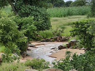
The Ferlo Desert occupies an area of some 70,000 km2, over one-third of the country's total area. [3] It forms part of the region of Djourbel which extends to within 45 miles (70 km) to the east of Dakar to the west and south of St Louis, known as "Baol" to the locals. [4] The Senegal River flows through the region, [5] and valleys occur in the Sine Saloum Delta north of The Gambia. [6] There are endless plains and sand dunes, with scattered rocks and small valleys with clay soils in which small water bodies form. The plain is crossed by the courses of numerous tributaries of the Senegal River, which for most of the year are dry and fill with water only occasionally during the rainy season (July to September).
The climate is very dry, characterised by a long dry season (which lasts for nine months a year), with winds from the very dry Sahara Desert. The wet season, in the period from July to September, is short and brings irregular rainfall brought by the humid air masses from the Gulf of Guinea. Due to the arid climate the region is sparsely populated; the area was also plagued by drought in the early 1970s and again in 1983–1984. [7] Linguère, with nearly 13,000 inhabitants, is the largest town in this region. Desertification has also contributed to a regional population decline.
The semi-desert zone of the Ferlo is known for its baobab trees. Leguminous plants such as Zornia glochidiata and Alysicarpus ovalifolius and Graminaceae such as Cenchrus biflorus , Dactyloctenium aegyptium , Chloris prieurii , Eragrotis tremula , Aristida mutabilis and Schonefeldia gracilis have been observed. [7] The national reserves Ferlo Nord Wildlife Reserve (Réserve de faune du Ferlo Nord) (RFFN) and Ferlo Sud Wildlife Reserve (Réserve de faune du Ferlo Sud) (RFFS) lie within the Ferlo desert region. [8] Ferlo Nord Wildlife Reserve, established in 1971, covers an area of 6,000 square kilometres (2,300 sq mi). Ferlo Sud Wildlife Reserve was established the following year, and is a little larger at 6,337 square kilometres (2,447 sq mi).
This region of Senegal is destitute, and living conditions are difficult. The population are mainly engaged in ranching. The main crops cultivated are millet, cowpeas, peanuts, watermelons and squash and Acacia gum. [8] [9]
The natural grasslands of the desert have undergone change. Until the mid-1950s the region "was visited by people and livestock only during the rainy season and at the very beginning of the dry season (July to November)." [7] In 1953, J. G. Adam noted that the "groundnut cultivation has transformed the natural vegetation on sandy soils, to note, even at a distance from the water points, a climax, subclimax vegetation which has not been disrupted by cultivation, and hardly changed by grazing, since this has occurred only, until recent years, during the four summer months, where the vegetation is dense and close to standing water." [7] From the mid-1950s, boreholes were drilled and began to provide water to areas of the desert, which enabled pastureland to be used by the farmers all year round. By 1955, fifty wells were reported along the main trek routes to be providing water. [10] Under better conditions, the population of livestock in the desert increased; by the 1990s, it supported livestock herding, cited as "a continuous extension of the desert steppe into the savanna" but one which was "not rich enough to attract herders from the north of the [Senegal] river." [7] [11] Between 1969 and 1972, the "Study of Natural Pastureland in Northern Senegal" was conducted, assessing the borehole development in the desert and found that the boreholes were still on average 25–30 km apart, which meant that exploitation of land was generally restricted to a 5 km radius of them. [7] Spate irrigation has since developed in the region, and temporary ponds may cover an area of several hectares during the wet season from July to October. [12]

The Kalahari Desert is a large semi-arid sandy savanna in Southern Africa extending for 900,000 square kilometres (350,000 sq mi), covering much of Botswana, as well as parts of Namibia and South Africa.

At 824,292 km2 (318,261 sq mi), Namibia is the world's thirty-fourth largest country. After Mongolia, Namibia is the second least densely populated country in the world. Namibia got its name from the Namib desert that stretches along the coast of the Atlantic. It is also known for its wildlife.

Senegal is a coastal West African nation located 14 degrees north of the equator and 14 degrees west of the Prime Meridian. The country's total area is 196,190 km2 of which 192,000 km2 is land and 4,190 km2 is water.
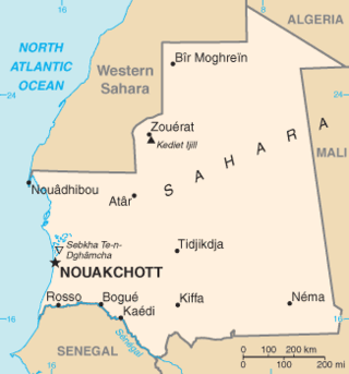
Mauritania, a country in the Western Region of the continent of Africa, is generally flat, its 1,030,700 square kilometres forming vast, arid plains broken by occasional ridges and clifflike outcroppings. Mauritania is the world’s largest country lying entirely below an altitude of 1,000 metres (3,300 ft). It borders the North Atlantic Ocean, between Senegal and Western Sahara, Mali and Algeria. It is considered part of both the Sahel and the Maghreb. A series of scarps face southwest, longitudinally bisecting these plains in the center of the country. The scarps also separate a series of sandstone plateaus, the highest of which is the Adrar Plateau, reaching an elevation of 500 metres or 1,640 feet. Spring-fed oases lie at the foot of some of the scarps. Isolated peaks, often rich in minerals, rise above the plateaus; the smaller peaks are called Guelbs and the larger ones Kedias. The concentric Guelb er Richat is a prominent feature of the north-central region. Kediet ej Jill, near the city of Zouîrât, has an elevation of 915 metres or 3,002 feet and is the highest peak.

The Sahel region or Sahelian acacia savanna is a biogeographical region in Africa. It is the transition zone between the more humid Sudanian savannas to its south and the drier Sahara to the north. The Sahel has a hot semi-arid climate and stretches across the southernmost latitudes of North Africa between the Atlantic Ocean and the Red Sea. Although geographically located in the tropics, the Sahel does not have a tropical climate.

Rangelands are grasslands, shrublands, woodlands, wetlands, and deserts that are grazed by domestic livestock or wild animals. Types of rangelands include tallgrass and shortgrass prairies, desert grasslands and shrublands, woodlands, savannas, chaparrals, steppes, and tundras. Rangelands do not include forests lacking grazable understory vegetation, barren desert, farmland, or land covered by solid rock, concrete and/or glaciers.

The Highveld is the portion of the South African inland plateau which has an altitude above roughly 1500 m, but below 2100 m, thus excluding the Lesotho mountain regions to the south-east of the Highveld. It is home to some of the country's most important commercial farming areas, as well as its largest concentration of metropolitan centres, especially the Gauteng conurbation, which accommodates one-third of South Africa's population.
The Sudanian savanna or Sudan region is a broad belt of tropical savanna that runs east and west across the African continent, from the Ethiopian Highlands in the east to the Atlantic Ocean in the west. It represents the central bioregion within the broader tropical savanna biome of the Afrotropical realm. The Sahel acacia savanna, a belt of drier grasslands, lies to the north, forming a transition zone between the Sudanian savanna and the Sahara Desert phytochorion. To the Sudan's south, the more humid forest-savanna mosaic forms a transition zone between the Sudanian savanna and the Guineo-Congolian forests that lie nearer the equator.

Burkina Faso is largely wild bush country with a mixture of grass and small trees in varying proportions. The savanna region is mainly grassland in the rainy season and semi desert during the harmattan period. Fauna, one of the most diverse in West Africa, includes the elephant, hippopotamus, buffalo, monkey, lions, crocodile, giraffe, various types of antelope, and a vast variety of bird and insect life. The country has 147 mammal species, 330 aquatic species including 121 species of fish and 2067 different plant species. Of the plant species, the dominant endemic species are shea tree and the baobab, the former plant species has immense economic value to the country.

The wildlife of Chad is composed of its flora and fauna. Bush elephants, West African lions, buffalo, hippopotamuses, Kordofan giraffes, antelopes, African leopards, cheetahs, hyenas, and many species of snakes are found there, although most large carnivore populations have been drastically reduced since the early 20th century. Elephant poaching, particularly in the south of the country in areas such as Zakouma National Park, is a severe problem.

The wildlife of the Gambia is dictated by several habitat zones over the Gambia's land area of about 10,000 km2. It is bound in the south by the savanna and on the north by the Sudanian woodlands. The habitats host abundant indigenous plants and animals, in addition to migrant species and newly planted species. They vary widely and consist of the marine system, coastal zone, estuary with mangrove vegetation coupled with Banto Faros, river banks with brackish and fresh water zones, swamps covered with forests and many wetlands.
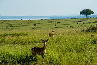
The wildlife of Senegal consists of the flora and fauna of this nation in West Africa. Senegal has a long Atlantic coastline and a range of habitat types, with a corresponding diversity of plants and animals. Senegal has 188 species of mammals and 674 species of bird.
The gracile tateril or slender gerbil is a species of rodent found in Burkina Faso, Chad, Gambia, Ghana, Guinea, Ivory Coast, Mali, Niger, Nigeria, Senegal, Togo, and possibly Cameroon. Its natural habitats are dry savanna, arable land, pastureland, and rural gardens. It is a common species, sometimes considered an agricultural pest, and the International Union for Conservation of Nature has rated its conservation status as being of "least concern".
The wildlife of Sudan is composed of its flora and fauna. A variety of climate types in Sudan results in a wide range of habitats and the range of wildlife is diverse. Some 287 species of mammal have been recorded in the country and some 634 species of bird.
The wildlife of Mali, composed of its flora and fauna, is widely varying from the Saharan desert zone to the Sahelian east–west zone, to Mali, a landlocked francophone country in North Africa; large swathes of Mali remain unpopulated but has three sub-equal vegetation zones; the country has Sahara Desert in the north, the Niger River Basin at its center and the Senegal River on the south.

The Termit Massif Total Reserve is a nature reserve in the southeast of Niger which was established in January 1962. In March 2012, a national nature and cultural reserve was established covering an area of 100,000 square kilometres (39,000 sq mi), including the entire area of the Termit Massif and Tin Toumma desert, making it the largest single protected area in Africa. The area provides habitat for many critically endangered species. Prominent among them is the addax antelope, which is categorized under the IUCN Red List as one of the rarest and most endangered species in the world; about 300 of them are reported in the reserve. A conservation effort has been launched by the Government of Niger in collaboration with many international conservation agencies. The reserve has also been declared an UNESCO World Heritage Site for the biodiversity value of the Termit Massif and surrounding Sahara Desert and for the cultural value of its archaeological sites.
Under UNESCO’s Man and the Biosphere Programme (MAB), there are 70 biosphere reserves recognized as part of the World Network of Biosphere Reserves in African states as of 2016. These are distributed across 28 countries. While biosphere reserves in West African, East African, Central African and Southern African countries are organised in the AfriMAB regional network, biosphere reserves in Northern African countries are organised in the ArabMAB, UNESCO's regional MAB network.
The Ferlo Nord Wildlife Reserve, established in 1971, is a 6,000 square kilometres (2,300 sq mi) IUCN habitat and species protected nature reserve located in Senegal. The nature reserve is bordered by the Ferlo Sud Wildlife Reserve to the south.
The Ferlo Sud Wildlife Reserve, established in 1972, is a 6,337 square kilometres (2,447 sq mi) IUCN habitat and species protected nature reserve located in Senegal. The nature reserve is bordered by the Ferlo Nord Wildlife Reserve to the north.

The wildlife of Mongolia consists of flora, fauna and funga found in the harsh habitats dictated by the diverse climatic conditions found throughout the country. In the north, there are salty marshes and fresh-water sources. The centre has desert steppes. In the south, there are semi deserts as well as the hot Gobi desert in the south, the fifth-largest desert in the world.