Related Research Articles

The Sonoran Desert is a desert in North America and ecoregion that covers the northwestern Mexican states of Sonora, Baja California, and Baja California Sur, as well as part of the southwestern United States. It is the hottest desert in both Mexico and the United States. It has an area of 260,000 square kilometers (100,000 sq mi).

California's Colorado Desert is a part of the larger Sonoran Desert. It encompasses approximately 7 million acres, including the heavily irrigated Coachella and Imperial valleys. It is home to many unique flora and fauna.

The flat-tail horned lizard is a species of lizard in the family Phrynosomatidae. A species of reptile, it is endemic to the Sonoran desert of the southwestern United States and northwestern Mexico. Its multiple adaptations for camouflage help to minimize its shadow. The species is threatened, with a restricted range under pressure from human activities such as agriculture and development, and is specially protected in the United States.
The Chuckwalla Mountains are a mountain range in the transition zone between the Colorado Desert—Sonoran Desert and the Mojave Desert, climatically and vegetationally, in Riverside County of southern California.

The Living Desert Zoo and Gardens, formerly the Living Desert Museum, is a non-profit zoo and desert botanical garden located in Palm Desert, Riverside County, California, United States. The Living Desert is home to over 500 animals representing over 150 species and welcomes over 500,000 visitors annually. Situated in the Sonoran Desert of the Coachella Valley and Santa Rosa Mountains foothills near Palm Springs, California, The Living Desert is set on 1,200 acres, with 80 developed as zoo and gardens.

The Turtle Mountains, are located in northeastern San Bernardino County, in the southeastern part of California. The colorful Turtle Mountains vary from deep reds, browns, tans and grays, to black. The area has numerous springs and seeps. The Turtle Mountains are also a National Natural Landmark, with two mountain sections of entirely different composition.

The Whipple Mountains are located in eastern San Bernardino County, California. They are directly west of the Colorado River, Parker Dam, and Lake Havasu; south of Needles, California; north of Parker, Arizona and Vidal, California; and northeast of Vidal Junction, California.

The Santa Rosa and San Jacinto Mountains National Monument is a National Monument in southern California. It includes portions of the Santa Rosa and San Jacinto mountain ranges, the northernmost ones of the Peninsular Ranges system. The national monument covers portions of Riverside County, west of the Coachella Valley, approximately 100 miles (160 km) southeast of downtown Los Angeles.
Sonoran Desert National Monument is south of Goodyear and Buckeye and east of Gila Bend, Arizona. Created by Presidential proclamation on January 17, 2001, the 496,400 acres (200,886 ha) monument is managed by the U.S. Bureau of Land Management as part of the National Landscape Conservation System. The BLM already managed the lands, however under monument status, the level of protection and preservation of resources is enhanced. Sonoran Desert National Monument protects but a small portion of the Sonoran Desert, which is 120,000 square miles (311,000 km2), and extends well into California and the country of Mexico. The North Maricopa Mountains, South Maricopa Mountains and the Table Top Wildernesses protect the richest regions of desert habitat from development.

The Big Morongo Canyon Preserve is a 31,000-acres (130 km2) native plants habitat and wildlife preserve located in the Little San Bernardino Mountains of the Transverse Ranges, in the transition zone between the higher Mojave Desert and lower elevation Colorado Desert section of the Sonoran Desert. Due to its location within this transition zone, the area is especially high in natural diversity. The natural spring fed desert oasis found here is one of the 10 largest Cottonwood and Willow riparian habitats in California. It is also identified by the Audubon Society as one of the most important avian habitat areas in California.

Aridoamerica denotes an ecological region spanning Northern Mexico and the Southwestern United States, defined by the presence of the culturally significant staple foodstuff Phaseolus acutifolius, a drought-resistant bean. Its dry, arid climate and geography stand in contrast to the verdant Mesoamerica of present-day central Mexico into Central America to the south and east, and the higher, milder "island" of Oasisamerica to the north. Aridoamerica overlaps with both.

The Sawtooth Mountains Wilderness is a federal wilderness area of 32,136 acres (130.0 km2) located in the Sawtooth Mountains in eastern San Diego County, California. It is located in the Colorado Desert, 35 miles (56 km) south of Borrego Springs, near Anza Borrego Desert State Park.
The Cleghorn Lakes Wilderness is a 39,167-acre (158.50 km2) wilderness area in the southern Mojave Desert. It is located 16 miles (26 km) northeast of Twentynine Palms, California, and 20 miles (32 km) north of Joshua Tree National Park. It is managed by the Bureau of Land Management.

The Sonny Bono Salton Sea National Wildlife Refuge is located in the Imperial Valley of California, 40 miles (64 km) north of the Mexican border. Situated at the southern end of the Salton Sea, the refuge protects one of the most important nesting sites and stopovers along the Pacific Flyway. Despite its location in the Colorado Desert, a subdivision of the larger Sonoran Desert, the refuge contains marine, freshwater, wetland, and agricultural habitats which provide sanctuary for hundreds of birds and wetland species, including several that have been listed as endangered or sensitive by the U.S. Fish and Wildlife Service.
The Whipple Mountains Wilderness is a 76,122-acre (30,805 ha) wilderness administered by the Bureau of Land Management (BLM). Most of the Whipple Mountains are within the wilderness area. It is located in the northeastern Colorado Desert near the Colorado River. Lake Havasu and Lake Havasu City are 25 miles (40 km) to the North. Earp, California and Parker, Arizona are 20 miles (32 km) to the South. The Parker Dam is 8 miles (13 km) due east.
The fauna of the State of California may be the most diverse in the United States of America. Of the Lower 48 conterminous states, California has the greatest diversity in climate, terrain and geology in general. The state's six life zones are the lower Sonoran (desert); upper Sonoran ; transition ; and the Canadian, Hudsonian, and Arctic zones, comprising California's highest elevations. California’s diverse geography gives rise to dozens of different ecosystems, each of which has its own unique native plants and animals. California is a huge state, the 3rd largest in the U.S., and can range broadly in habitat type.
San Felipe Creek is a stream in Imperial and San Diego Counties of California. It arises in the Volcan Mountains of San Diego County 33°11′57″N116°37′35″W, and runs eastward, gathering the waters of most of the eastern slope of the mountains and desert of the county before it empties into the Salton Sea. It is probably the last remaining perennial natural desert stream in the Colorado Desert region. In 1974, the San Felipe Creek Area was designated as a National Natural Landmark by the National Park Service.

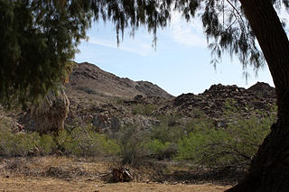
Dos Palmas Preserve is a 14,000-acre (5,700 ha) wildlife preserve in the Colorado Desert in Riverside County, California, in the United States. The preserve is within the Salt Creek Area of Critical Environmental Concern, and is managed by the Bureau of Land Management. It contains a large oasis and wetland habitat, with pools fed both by water seeping from the Coachella Canal and by artesian water from several springs, including the Dos Palmas Spring. Desert fan palms are abundant.

Sand to Snow National Monument is a U.S. National Monument located in San Bernardino County and northern Riverside County, Southern California.
References
- ↑ "Yuha Desert Cultural History Audio Tour". Bureau of Land Management. Retrieved 31 January 2015.
- ↑ Farah, Troy (2021-01-18). "Trump administration proposes 11th-hour plan to strip California desert protections". the Guardian. Retrieved 2021-01-20.
This article needs additional citations for verification .(January 2017) |