
A dune is a landform composed of wind- or water-driven sand. It typically takes the form of a mound, ridge, or hill. An area with dunes is called a dune system or a dune complex. A large dune complex is called a dune field, while broad, flat regions covered with wind-swept sand or dunes, with little or no vegetation, are called ergs or sand seas. Dunes occur in different shapes and sizes, but most kinds of dunes are longer on the stoss (upflow) side, where the sand is pushed up the dune, and have a shorter slip face in the lee side. The valley or trough between dunes is called a dune slack.
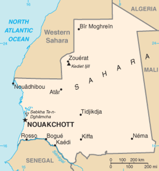
Mauritania, a country in the Western Region of the continent of Africa, is generally flat, its 1,030,700 square kilometres forming vast, arid plains broken by occasional ridges and clifflike outcroppings. Mauritania is the world’s largest country lying entirely below an altitude of 1,000 metres (3,300 ft). It borders the North Atlantic Ocean, between Senegal and Western Sahara, Mali and Algeria. It is considered part of both the Sahel and the Maghreb. A series of scarps face southwest, longitudinally bisecting these plains in the center of the country. The scarps also separate a series of sandstone plateaus, the highest of which is the Adrar Plateau, reaching an elevation of 500 metres or 1,640 feet. Spring-fed oases lie at the foot of some of the scarps. Isolated peaks, often rich in minerals, rise above the plateaus; the smaller peaks are called Guelbs and the larger ones Kedias. The concentric Guelb er Richat is a prominent feature of the north-central region. Kediet ej Jill, near the city of Zouîrât, has an elevation of 915 metres or 3,002 feet and is the highest peak.

Aeolian processes, also spelled eolian, pertain to wind activity in the study of geology and weather and specifically to the wind's ability to shape the surface of the Earth. Winds may erode, transport, and deposit materials and are effective agents in regions with sparse vegetation, a lack of soil moisture and a large supply of unconsolidated sediments. Although water is a much more powerful eroding force than wind, aeolian processes are important in arid environments such as deserts.
Nova Kakhovka is a city in Kakhovka Raion, Kherson Oblast, southern Ukraine. Nova Kakhovka has been under Russian occupation since February 2022. Its estimated population in 2022 was 44,427.

Kherson Oblast, also known as Khersonshchyna, is an oblast (province) in southern Ukraine. It is located just north of Crimea. Its administrative center is Kherson, on the northern or right bank of the Dnieper river, which bisects the oblast. The oblast has an area of 28,461 km2 and a population of 1,001,598. It is considered the 'fruit basket' of the country, as much of its agricultural production is dispersed throughout the country, with production peaking during the summer months.

The Volga Delta is the largest river delta in Europe and occurs where Europe's largest river system, the Volga River drains into the Caspian Sea in Russia's Astrakhan Oblast, north-east of the republic of Kalmykia. The delta is located in the Caspian Depression—the far eastern part of the delta lies in Kazakhstan. The delta drains into the Caspian approximately 60 km (37 mi) downstream from the city of Astrakhan.

The Algodones Dunes is a large sand dune field, or erg, located in the southeastern portion of the U.S. state of California, near the border with Arizona and the Mexican state of Baja California. The field is approximately 45 miles (72 km) long by 6 miles (9.7 km) wide and extends along a northwest-southeast line that correlates to the prevailing northerly and westerly wind directions. The name "Algodones Dunes" refers to the entire geographic feature, while the administrative designation for that portion managed by the Bureau of Land Management is the Imperial Sand Dunes Recreation Area. In 1966, Imperial Sand Hills was designated as a National Natural Landmark by the National Park Service. The Algodones Dunes are split into many different sections. These sections include Glamis, Gordon's Well, Buttercup, Midway, and Patton's Valley. Although the Arabic-derived Spanish word algodones translates to "cotton plants", the origin of the toponym is unknown.

Błędów Desert, is an area of sands and gravels located between Błędów and the villages of Chechło and Klucze in Poland. The area lies mainly on the Silesian Highlands in the Lesser Poland Voivodeship. The Błędów Desert is Central Europe's largest accumulation of loose sand in an area away from any sea, deposited thousands of years ago by a melting glacier. It occupies an area of 32 km2 (12 sq mi). The sands have an average depth of 40 m, up to 70 m at the maximum. The Biała Przemsza River divides the desert in two from east to west. The northernmost part of the desert is closed to visitors because it is a military zone, where exercises take place.

The Inhulets or Ingulets is a river, a right tributary of the Dnieper, that flows through Ukraine. It has a length of 557 kilometres (346 mi) and a drainage basin of 14,460 square kilometres (5,580 sq mi).

Deliblato Sands is a large sand area covering around 300 km2 (120 sq mi) of ground in Vojvodina province, Serbia. It is located in southern Banat, situated between the river Danube and the southwestern slopes of the Carpathian Mountains. The sands are named after the village of Deliblato, in the municipality of Kovin. Its main masses are elliptical shaped hills with steppe grassland plains and steppe forests.

Oleshky, previously known as Tsiurupynsk from 1928 to 2016, is a city in Kherson Raion, Kherson Oblast, southern Ukraine, located on the left bank of the Dnieper River with the town of Solontsi to the south. It is the oldest city of the oblast and one of the oldest in southern Ukraine. It is known for its proximity to the Oleshky Sands, a large desert region. Oleshky is the site of artist Polina Rayko's home, a national cultural monument of Ukraine. It also hosts the administration of Oleshky urban hromada, one of the hromadas of Ukraine. It had a population of 24,124.
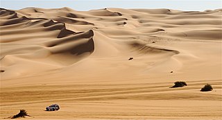
A desert is a landscape where little precipitation occurs and, consequently, living conditions create unique biomes and ecosystems. The lack of vegetation exposes the unprotected surface of the ground to denudation. About one-third of the land surface of the Earth is arid or semi-arid. This includes much of the polar regions, where little precipitation occurs, and which are sometimes called polar deserts or "cold deserts". Deserts can be classified by the amount of precipitation that falls, by the temperature that prevails, by the causes of desertification or by their geographical location.
Poima or Poyma, known as Tsiurupynsk before 2016, is a rural-type settlement in Ukraine, located in Oleshky urban hromada, Kherson Raion, Kherson Oblast.

The Kinburn Spit is a spit in Mykolaiv Raion, Mykolaiv Oblast, Ukraine. Its only land access is through Kherson Oblast. It occupies the westernmost part of the Kinburn Peninsula, stretching west into the Black Sea between the Dnieper-Bug estuary to the north and the Yahorlyk Bay to the south. It is approximately 10 kilometres (6.2 mi) long, with a width of about 1 kilometre (0.62 mi) at its base, narrowing to about 100 metres (330 ft) in its western half.

Oleshky Sands National Nature Park is a national park of Ukraine, located south of the lower Dnieper River about 25 km east of the regional city of Kherson, and 70 km northwest of the Crimean Peninsula. The park features expanses of low-fertility soil and sand, and a variety of unusual microhabitats. The area is not a true desert, but rather semi-arid. As of 2019, visits by unaccompanied members of the public were strictly prohibited, with warnings that the area was next to a military training ground. The park is located in Kherson Oblast, in territory currently occupied by Russia.
Nova Maiachka is a rural settlement in Kherson Raion, Kherson Oblast, southern Ukraine. It is located approximately 30 kilometres (19 mi) east of the city of Kherson, next to Oleshky Sands. Nova Maiachka belongs to Yuvileine rural hromada, one of the hromadas of Ukraine. It has a population of 6,585.
Yuvileine is a village located in Kherson Raion, Kherson Oblast, Ukraine, south-east of the town of Oleshky. It hosts the administration of the Yuvileine rural hromada, one of the hromadas of Ukraine.
Vynohradove is a village (selo) in southern Ukraine, located in Kherson Raion, Kherson Oblast. Before 1946, it was named Chalbasy. It has a population of 4636 people. It is the center of Vynohradove rural hromada.
Krynky is a village in Oleshky urban hromada, Kherson Raion, Kherson Oblast. It is located on the east bank of the Dnieper river.

