Firozabad

Last updated

Firozabad
City
Firozabad UP 2.jpg
Mahavir Digambar Jain temple of Firozabad, Uttar Pradesh
India Uttar Pradesh location map.svg
Red pog.svg
Firozabad
India location map.svg
Red pog.svg
Firozabad
Coordinates: 27°09′N78°25′E / 27.15°N 78.42°E / 27.15; 78.42
CountryFlag of India.svg  India
State Uttar Pradesh
District Firozabad
Government
  Type Municipal Corporation
  Body Firozabad Municipal Corporation
  Member of Parliament (MP)Dr. Chandrasen Jadon (BJP)
  MayorKamini Rathore (BJP) [1]
  Member of Legislative Council (MLC)Dr. Dilip Yadav (SP)
   District Magistrate IAS
Population
 (2011 census)
  Total603,797
Languages
  Official Hindi
Urdu
Time zone UTC+5:30 (IST)
PIN
283203
Telephone code05612
Vehicle registration UP-83
Website firozabad.nic.in

Firozabad is a city near Agra in Firozabad district in the state of Uttar Pradesh in India. It is the centre of India's glassmaking industry and is known for the quality of the bangles and glassware produced here.

Contents

During the reign of Akbar, revenue was brought through the city, which was looted by the Afghans. Akbar sent his army led by the Mansab Dar, Firoz Shah, to make the city a cantonment to collect taxes and the city of Chandrawar was renamed as Firozabad after him. The tomb of Firoz Shah is still present today. From early times, it had glass and bangle works, and small scale industry. The landowners of Firozabad hail from the Siddiqui, Sayed, Manihar, Pathan and the Hindu Rajput castes. Firozabad is located in north central India, in Uttar Pradesh, 37 km (23 mi) from Agra and around 230 km (140 mi) from Delhi, at the northern edge of the Deccan Plateau, at 27°09′N78°24′E / 27.150°N 78.400°E / 27.150; 78.400 . It is located 164 metres (538 ft) above sea level.

The boundaries of Firozabad district touch Etah district in north and Mainpuri and Etawah districts in the east. The Yamuna river makes its southern boundary.

History

The city lies in the cultural region of Braj and was a part of the Surasena Mahajanapada during the Vedic Age. It was subsequently ruled by the bigger kingdoms including the Mauryas, Guptas, Scythians, Kushans, Indo-Greeks, Harsha before falling into the hands of Brahmin Peshwa, Rajput rulers. [2]

Before the foundation of modern Firozabad, the main city in the area was at Chandwar, on the left bank of the Yamuna a short distance southwest of Firozabad. Chandwar was a stronghold of the Chauhan Rajputs from an early date, which was founded by a ruler named Chandrasen according to tradition. Chandwar was conquered several times by the Delhi Sultanate, but its Chauhan rulers seem to have repeatedly asserted their independence over a period of several centuries. One tradition holds that the final defeat of the king Jayachandra by Muhammad of Ghor took place here, at the Battle of Chandwar. According to family traditions of the Bhadaurias, another conquest of Chandwar happened in 1246, which may be corroborated by the records kept by the Sultanate, which mention the capture of an unnamed Hindu stronghold in that same year. Then, after the Delhi Sultan Khizr Khan came to power in 1414, his general Taj ul-Mulk received submission from "the infidels of Chandwar" and then, in 1420, he sacked and looted Chandwar as punishment of some sort. In 1452, Chandwar was the site of a major battle between the Delhi and Jaunpur Sultanates, which led to a three-year truce between the two empires. [3]

The modern city of Firozabad was founded c. 1566, when Raja Todar Mal was returning from a pilgrimage to Gaya and stopped at the village of Asafabad (just southeast of modern Firozabad). The villagers insulted him, and when the emperor Akbar heard of this, he sent the eunuch Firoz Khwaja to demolish the town and build a new one. The city was built on lands belonging to several neighboring villages, including Akbarabad, Sukhmalpur, Muhammadpur-Gajmalpur, Rasulpur, and Pempur-Raipur, and it was named Firozabad in honor of its founder. Firoz Khwaja's tomb, built of white marble, is by the road to Agra. [3]

Mr. Peter, a businessman working for the Dutch East India Company visited Firozabad on 9 August 1632, and found the town in good condition. It is written in the gazetteer of Agra and Mathura that in 1596 Faraz was upgraded to a pargana . Faraz was bestowed to Nawab Sadulla Khan as jagir , in the regime of Shahjahan. Jahangir ruled here from 1605 to 1627. Etawah, Budaun, Mainpuri, Faraz were under first class mansabdar of emperor Farrukhsiar. Baji Rao I looted Firozabad and Etmadpur in 1737 in the regime of Mohammad Shah. Jats of Mahawan attacked Faujdar Hakim Kajim ali bahadur jang at Firozabad and killed him on 9 May 1739. Jats ruled Firozabad for 30 years. Gajuddin, Hidayat Vaksh son of Alamgir second his nephew and Mirza baba the son in law, came to Firozabad. Mirza Nabab Khan stayed here until 1782. In the end of the 18th century, Firozabad was ruled by Himmat Bahadur with co-operation of Marathas. The French Army chief of Marathas, D. Wayan, established an ordnance factory in November 1794. Mr. Thomas Traving also mentioned this fact in his book Travels in India. Marathas appointed his subedar Lakwadads here who made a fort near old tehsil, known at present as garie.

General Lek and General Vellajally attacked Firozabad in 1802. In the beginning of British regime Firozabad was in Etawah district but after some time it was attached to Aligarh district. When Sadabad was created as a new district in 1832, Firozabad was attached to it. Later on, in 1833 Firozabad was attached to Agra district. In 1847, the business of lac was flourishing at Firozabad.

In 1857, Zamindar of Firozabad with local public took active parts in freedom struggle. Urdu poet Munir Shikohabadi was sentenced to Kala pani by the British East India Company. People of this city took part in "Khilafat Movement", "Quit India Movement", and "Namak Satyagrah" and went to the jail during these national movements. In 1929, Father of Nation Mahatma Gandhi, in 1935 Khan Abdul Ghaffar Khan, in 1937 Pandit Jawahar Lal Nehru and in 1940 Subhas Chandra Bose visited Pandit Banarasi Das Chaturvedi, a two time member of Parliament - said to be the father of Hindi Journalism and the recipient of Padma Bushan. Firozabad district was finally established on 5 February 1989. In 2015 it became a Nagar Nigam.

Geography

Firozabad is located at 27°09′N78°25′E / 27.15°N 78.42°E / 27.15; 78.42 . [4]

Climate

The lowest recorded temperature in Firozabad was −1 °C (30 °F) and the highest was 48 °C (118 °F).

Climate data for Firozabad
MonthJanFebMarAprMayJunJulAugSepOctNovDecYear
Mean daily maximum °C (°F)22
(72)
25
(77)
32
(90)
38
(100)
41
(106)
41
(106)
35
(95)
33
(91)
34
(93)
34
(93)
29
(84)
24
(75)
32
(90)
Mean daily minimum °C (°F)8
(46)
10
(50)
16
(61)
22
(72)
26
(79)
28
(82)
27
(81)
26
(79)
24
(75)
19
(66)
13
(55)
9
(48)
19
(66)
Average precipitation mm (inches)10.2
(0.40)
12.7
(0.50)
10.2
(0.40)
10.2
(0.40)
15.2
(0.60)
66.0
(2.60)
195.6
(7.70)
226.1
(8.90)
114.3
(4.50)
27.9
(1.10)
2.5
(0.10)
5.1
(0.20)
696
(27.4)
Source: Firozabad Weather

Demographics

Religions in Firozabad City (2011) [5]
ReligionPercent
Hinduism
62.36%
Islam
33.80%
Jainism
1.76%
Other or not stated
2.08%

As of 2011 India census, Firozabad City had a population of 603,797. Males constitute 53% of the population and females 47%. Firozabad has an average literacy rate of 75.01% higher than the national average of 74%: male literacy is 85.32%, and female literacy is 63%. In Firozabad, 16% of the population is under 6 years of age. Scheduled Castes and Scheduled Tribes make up 16.55% and 0.39% of the population respectively. [6]

Languages in Firozabad (2011) [7]

   Hindi (90.83%)
   Urdu (9.03%)
  Others (0.14%)

The city lies in the cultural region of Braj and the local language is Brajbhasha.

Economy

Glass industry

Firozabad is the largest glass manufacturing centre in India, [8] :3 accounting for about 70% of the total glass production in the unorganised sector in India. [9] :10 It is estimated that over 50% of the city's population is employed "directly or indirectly" in the glass industry, [9] :10 with bangle manufacturing alone employing about 100,000 people. [10] :28 [note 1] Firozabad is the single largest producer of bangles in India, [10] :28 accounting for 46% of India's total production. [8] :5 Other products include things like glass tableware, laboratory glassware, glass containers, automotive glass, vases, chandeliers, and numerous decorative items. [9] :10–11 As of 2011, the total production of finished glass items in Firozabad is about 1,230 megatons per day. [8] :5 The percent of this that gets exported internationally is variously estimated to be about 35% [9] :10 or about 50%. [8] :5 As of 2011, the total annual revenue from Firozabad's glass industry was Rs. 23.26 billion. [8] :5

Working conditions for Firozabad glassworkers are often very poor. Workers are often forced to work 12-to-14-hour days or risk losing their jobs, workplace injuries are common, and the intense heat in glass furnaces often causes dehydration and heat exhaustion in workers, who often then have to borrow money for medical treatment. As of 1986, it was reported that the combination of heat, dust, and noise led to tuberculosis being widespread, and the average lifespan of glassworkers was reduced by 10 to 15 years.Child labour is also very common, with Neera Burra estimating that almost 50,000 children under the age of 14 were working in glass production in Firozabad as of 1986. [11] :1983–4

Transport

Firozabad railway station served by the Delhi-Howrah trunk route of the Indian Railways. Several trains serve the city connecting it to long and short distanced destinations including New Delhi, Howrah, Mumbai, Kanpur, Lucknow, Jaipur, Jammu Tawi, Amritsar, Jamshedpur, Patna, Aligarh, Agra, Hathras, Puri, Ajmer, Ambala, Bareilly, Mathura, Etawah, Basti, Gorakhpur and Tundla.

Tundla Junction railway station in the Tundla town (20 km west of Firozabad city on National Highway 2) of the Firozabad District is a major railway station of North Central Railways. Due to its proximity to Agra several trains on the Delhi Howrah route which don't stop at Firozabad station make a stop at Tundla Junction hence serving Firozabad as well as Agra cities.

The city is 45 km (28 mi) east from Agra on National Highway 19 which makes it an important stopover for the transport vehicles on this highway. Firozabad hence is connected to several bus services to the Western and Eastern parts of Uttar Pradesh state. Due to proximity to Agra and hence the borders of Uttar Pradesh with Rajasthan, Madhya Pradesh states several inter-state bus services also serve the city. Intra-city transport typically consists of Rickshaws and 3-wheelers

The city is well connected with Yamuna Expressway and Taj Expressway to national capital New Delhi and state capital Lucknow respectively.

Water pollution

Since few years, Firozabad has been suffering with a severe water pollution problem. The water has been polluted by the indiscriminate discharge of wastes by the industries. The water has been rendered practically unusable. Citizens have no option but to install water purifiers at home and use packaged drinking water for consumption. [12] [13] [14]

Tourist attractions

Lord Bahubali Jain Temple

In Suhag Nagari, holy center of "Jain Nagar" was established by Lt. Seth Chhadamilal. The temple has a 45-foot granite idol of Bahubali, the largest in North India, weighing more than 3500 tonnes. There are many Jain temples near this temple. [15]

Villages

The following 89 villages are counted as part of Firozabad CD block: [16] :117–9

  1. Alampur Anandipur
  2. Alampur Kaneta
  3. Alampura Jarkhi
  4. Alinagar Kenjra
  5. Allahdadpur
  6. Anandipur Karkauli
  7. Aquil Pur Damodarpur
  8. Baindi
  9. Balchandarpur
  10. Baramai
  11. Barkatpur
  12. Basaimohammadpur
  13. Basudeopur
  14. Bazidpur Kutubpur
  15. Bhikan Pur Sadasukh
  16. Bhikanpur Annadipur
  17. Bhondela
  18. Bijaipur Bhikanpur
  19. Bilahna
  20. Chandwar
  21. Daragpur
  22. Datauli
  23. Dhakpura
  24. Donkeli
  25. Fatehpur Anandipur
  26. Garhi Chhatrapat
  27. Gazipur
  28. Gudun
  29. Hamirpura
  30. Hardashpur Nisfi
  31. Hirangaon
  32. Itora
  33. Jahagirpur
  34. Jaindamai
  35. Jalalpur
  36. Jamalpur
  37. Jarauli Kalan
  38. Jarauli Khurd
  39. Jilupura
  40. Khagerai
  41. Khalilganj
  42. Khamkaranpur
  43. Kharsoli
  44. Khera Ganeshpur
  45. Kinharpur
  46. Kolamai
  47. Kurrikupa
  48. Ladupur Chakarpur
  49. Lalau
  50. Latura
  51. Lohari
  52. Mandua
  53. Matamai
  54. Matsena
  55. Milikhan Jahanpur
  56. Mondha
  57. Muhammadpur Biharipur
  58. Nagau
  59. Naglamulla
  60. Nagria
  61. Nanpi Pithani
  62. Nargapur
  63. Nasirpur
  64. Nurpur Kutubpur
  65. Paharpur
  66. Pharaul Nagaria
  67. Phulaichi
  68. Pilua
  69. Prempur Anandipur
  70. Ranipur
  71. Rasidpur Kaneta
  72. Rupaspur
  73. Salempur Anandipur
  74. Salempur Naglakhar
  75. Saragawan
  76. Saramai
  77. Satgai
  78. Sengai
  79. Shankarpur
  80. Sherpur Anandipur
  81. Sikahra Hardaspur
  82. Sufipur
  83. Ulau
  84. Undani
  85. Usaini
  86. Usmanpur
  87. Vijaypurnagla Bhavesingh
  88. Wazirpur Anandipur
  89. Wazirpur Jihalpur

Notes

  1. About 82,000 are stated to be employed in "micro-units", doing post-production work on bangles such as straightening, joining, cutting, and decorating, [8] :5 but the source does not specify if this represents the entire number of people employed in bangle manufacturing.

Related Research Articles

<span class="mw-page-title-main">Yamuna</span> River in India

The Yamuna is the second-largest tributary river of the Ganges by discharge and the longest tributary in India. Originating from the Yamunotri Glacier at a height of about 4,500 m (14,800 ft) on the southwestern slopes of Bandarpunch peaks of the Lower Himalaya in Uttarakhand, it travels 1,376 kilometres (855 mi) and has a drainage system of 366,223 square kilometres (141,399 sq mi), 40.2% of the entire Ganges Basin. It merges with the Ganges at Triveni Sangam, Prayagraj, which is a site of the Kumbh Mela, a Hindu festival held every 12 years.

<span class="mw-page-title-main">Agra</span> Metropolis in Uttar Pradesh, India

Agra is a city on the banks of the Yamuna river in the Indian state of Uttar Pradesh, about 230 kilometres (140 mi) south-east of the national capital Delhi and 330 km west of the state capital Lucknow. With a population of roughly 1.6 million, Agra is the fourth-most populous city in Uttar Pradesh and twenty-third most populous city in India.

<span class="mw-page-title-main">Etawah</span> City in Uttar Pradesh, India

Etawah, also known as Ishtikapuri, is a city on the banks of Yamuna River in the state of Western Uttar Pradesh in India. It is the administrative headquarters of Etawah District. Etawah's population of 256,838 makes it the 180th most populous city in India. The city lies 300 km (190 mi) southeast of the national capital New Delhi, 230 km (140 mi) northwest of the state capital Lucknow, 120 km east of Agra and 140 km west of Kanpur. The city was an important centre for the Indian Rebellion of 1857. It is also the sangam or confluence of the Yamuna and Chambal rivers. It is the 26th most populous city in Uttar Pradesh.

<span class="mw-page-title-main">Etah district</span> District of Uttar Pradesh in India

Etah district is one of the districts of Uttar Pradesh, India, since 1854. Etah City is the district headquarters. Etah district is a part of Aligarh Division.

<span class="mw-page-title-main">Firozabad district</span> District of Uttar Pradesh in India

Firozabad district is one of the western districts of the Indian state of Uttar Pradesh, which has Firozabad city as its district headquarters. The district is a part of the Agra division.

Shikohabad is a city and a municipal board in the Firozabad district of the Indian state of Uttar Pradesh.

<span class="mw-page-title-main">Tundla</span> Town in Uttar Pradesh, India

Tundla is a town and a municipal board in Firozabad district in the Indian state of Uttar Pradesh. It is an important railway junction between the Delhi-Kanpur main line and the Agra branch line. Tundla is a railway town that sprang up when the railway was built in the late 1800s. It is served by Tundla Junction railway station. As of 2011, Tundla has a population of 50,423 people, in 8,744 households.

<span class="mw-page-title-main">Tundla Junction railway station</span> Railway station in Uttar Pradesh, India

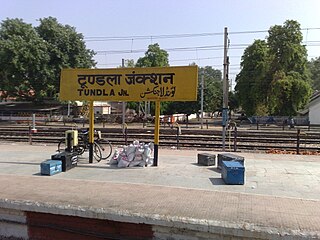
Tundla Junction is an important station in Uttar Pradesh. It is located on the Delhi–Howrah main line 25 km from Agra City. Tundla is a technical halt for changing drivers and guards for almost all of the trains on the New Delhi–Pandit Deen Dayal Upadhyaya Nagar / Lucknow sections. The station was built by the British and remains essentially unchanged. The railway station is a site in itself and takes one back to the pre-independence era.

<span class="mw-page-title-main">Kanpur–Delhi section</span> Railway line in India

The Kanpur–Delhi section is a railway line connecting Kanpur Central and Delhi. This section includes Agra Chord and Etah link. The main line is part of Howrah–Delhi main line and Howrah–Gaya–Delhi line. The Agra–Delhi chord is part of Delhi–Mumbai line and Delhi–Chennai line.

<span class="mw-page-title-main">Etawah Junction railway station</span> Railway station in Uttar Pradesh, India

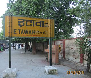
Etawah Junction railway station is one of the main railway stations on the Kanpur–Delhi section of Howrah–Delhi main line and Howrah-Gaya-Delhi line.It is 139 km (86 mi) away from Kanpur Central.Tundla is 92 km (57 mi) from here, from where lines to Agra bifurcates. It is located in Etawah district in the Indian state of Uttar Pradesh. It serves Etawah and the surrounding areas. Etawah stands near the confluence of the Yamuna and the Chambal.

<span class="mw-page-title-main">Hathras Junction railway station</span> Railway station in Uttar Pradesh, India

Hathras Junction railway station is on the Kanpur–Delhi section of Howrah–Delhi main line and Howrah–Gaya–Delhi line. It is located in Hathras district in the Indian state of Uttar Pradesh. It serves Hathras and surrounding areas.

<span class="mw-page-title-main">Firozabad railway station</span> Railway station in Uttar Pradesh, India

Firozabad railway station is on the Delhi-kanpur section of Delhi-Howarah Main line and Howrah–Gaya–Delhi line. It is located in Firozabad district in the Indian state of Uttar Pradesh. It serves Firozabad.

<span class="mw-page-title-main">Shikohabad Junction railway station</span> Railway station in Uttar Pradesh, India

Shikohabad Junction railway station is on the Kanpur-Delhi section of Howrah–Delhi main line and Howrah–Gaya–Delhi line. It is located in Firozabad district in the Indian state of Uttar Pradesh. It serves Shikohabad.

<span class="mw-page-title-main">Yamuna Bridge railway station</span> Railway station in Uttar Pradesh, India

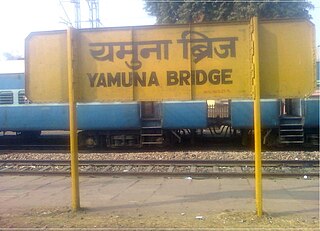
Yamuna Bridge railway station is on the Tundla–Agra branch line. It is located in Agra district in the Indian state of Uttar Pradesh. It serves Etmaddoula and surrounding neighbourhoods in Agra.

<span class="mw-page-title-main">Saifai</span> Village in Uttar Pradesh, India

Saifai is a large village and university town in the Etawah district of the Indian state of Uttar Pradesh. It is also a sub-division (Tehsil) and Block of the Etawah district. It is the birthplace of Mulayam Singh Yadav, the founding president of the Samajwadi Party, former Minister of Defence in India, and former Chief Minister of Uttar Pradesh.

<span class="mw-page-title-main">Phaphund railway station</span> Railway station in Uttar Pradesh

Phaphund railway station is an "A" graded railway station in Auraiya district, Uttar Pradesh, India. Its code is PHD. It serves Auraiya district and Dibiyapur city. It is located on the Kanpur–Delhi section of Howrah–Delhi main line and Howrah–Gaya–Delhi line. It is one of the main serving railway stations on the Kanpur–Delhi section of the Prayagraj railway division. Built during British rule, the station is owned by Indian Railways and operated by North Central Railway and consists of five tracks and four platforms.

<span class="mw-page-title-main">Chulhawali</span> Village in Uttar Pradesh, India

Chulhawali, also spelled Chulhaoli, is a village in Tundla block of Firozabad district, Uttar Pradesh. As of 2011, it has a population of 7,151, in 1,211 households. The population is mainly Hindu, with the most prominent community being Jats of the Solanki gotra. Other castes include Brahmans and Jatavs (ravidasiya).

<span class="mw-page-title-main">National Highway 19 (India)</span> National highway in India

National Highway 19 is a national highway in India. It was previously referred to as Delhi–Kolkata Road and is one of the busiest national highways in India. After renumbering of national highways, Delhi to Agra route is now national highway 44 and Agra to Kolkata route is numbered national highway 19. It constitutes a major portion of the historical Grand Trunk Road. It is also part of AH1 of Asian Highway Network, that traverses from Japan to Turkey.

<span class="mw-page-title-main">Dhirpura</span> Village in Uttar Pradesh, India

Dhirpura is a large village in Tundla block and tehsil of Firozabad district, Uttar Pradesh. It is located in the southeastern corner of the tehsil, on the north bank of the Yamuna river. Besides the main site, there are also numerous outlying hamlets. As of 2011, Dhirpura has a population of 14,478, in 2,210 households.

<span class="mw-page-title-main">Chandwar</span> Village in Uttar Pradesh, India

Chandwar is a village in Firozabad block of Firozabad district, Uttar Pradesh, India. Although now a humble village, it was historically the main town in the region during the Middle Ages. As of 2011, it had a population of 12,004, in 2,101 households.

References

  1. "BJP's Kamini Rathore becomes new Firozabad Mayor". ET Now News. Retrieved 22 May 2023.
  2. "Census of India 2001: Data from the 2001 Census, including cities, villages and towns (Provisional)". Census Commission of India. Archived from the original on 16 June 2004. Retrieved 1 November 2008.
  3. 1 2 Nevill, H.R. (1905). Agra: A Gazetteer. Allahabad: Government Press. pp. 137–85, 238–9, 274–80. Retrieved 22 January 2021.
  4. Falling Rain Genomics, Inc - Firozabad
  5. "Table C-01 Population by Religion: Uttar Pradesh". censusindia.gov.in. Registrar General and Census Commissioner of India. 2011.
  6. "District Census Handbook: Firozabad" (PDF). censusindia.gov.in. Registrar General and Census Commissioner of India. 2011.
  7. "2011 Census of India, Population By Mother Tongue - Uttar Pradesh (Town Level)". censusindia.gov.in. Registrar General and Census Commissioner of India . Retrieved 27 June 2022.
  8. 1 2 3 4 5 6 International Seminar on Inclusive Development of Firozabad Glass Art Ware Industry/Adoption of Advanced Technology & Design Innovations (PDF). Agra: National Centre for Design and Product Development. 2011. Retrieved 17 February 2024.
  9. 1 2 3 4 Srivastava, Vishal; Katyal, Anshul; Lal, K. P. (2019). Cluster Diagnostic Report and Action Plan Glass Cluster, Firozabad (PDF). Technology Centre System Programme. Retrieved 17 February 2024.
  10. 1 2 "Glass Bangles of Firozabad (A Preview)" (PDF). Kañch. 4 (3). All-India Glass Manufacturers' Federation: 28–9. 2011. Retrieved 17 February 2024.
  11. Burra, Neera (1986). "Glass Factories of Firozabad: I: Plight of Workers". Economic and Political Weekly. 21 (46): 1983–5. Retrieved 17 February 2024.
  12. http://www.icontrolpollution.com/articles/physicochemical-characteristics-of-glass-industries-waste-water-in-firozabad-district-up-india.pdf [ bare URL PDF ]
  13. "Agra: Family of six attempts suicide after facing acute water scarcity | Agra News - Times of India". The Times of India. 23 June 2019.
  14. https://www.krishisanskriti.org/vol_image/11Sep201505090522.pdf Archived 28 March 2022 at the Wayback Machine [ bare URL PDF ]
  15. "Lord Bahubali Temple". Uttar Pradesh Tourism . Retrieved 8 February 2019.
  16. "Census of India 2011: Uttar Pradesh District Census Handbook - Firozabad, Part A (Village and Town Directory)" (PDF). Census of India. Retrieved 19 June 2023.