Geography of the Solomon Islands

Last updated
Geography of Solomon Islands
Solomon Islands 1989.jpg
Continent Pacific Ocean
Region Oceania
Coordinates 8°00′S159°00′E / 8.000°S 159.000°E / -8.000; 159.000
Area Ranked 139th
  Total29,000 [1] [2]  km2 (11,000 sq mi)
  Land96.8%
  Water3.2%
Coastline5,313 km (3,301 mi)
BordersNone
Highest point Mount Popomanaseu
2,332 metres (7,651 ft)
Lowest point Pacific Ocean
0 m
Exclusive economic zone1,589,477 km2 (613,701 sq mi)

Solomon Islands is an island country in the South Pacific Ocean, that lies east of Papua New Guinea.

Contents

Islands

The major part of the nation of Solomon Islands is the mountainous volcanic islands of the Solomon Islands (archipelago), which includes Choiseul, the Shortland Islands, the New Georgia Islands, Santa Isabel, the Russell Islands, the Florida Islands, Tulagi, Malaita, Maramasike, Ulawa, Owaraha (Santa Ana), Makira (San Cristobal), and the main island of Guadalcanal. (The largest island in the archipelago is Bougainville, but it is politically an autonomous region of the neighbouring country of Papua New Guinea.) Solomon Islands also includes isolated low-lying atolls and volcanic islands such as Sikaiana, Rennell Island, Bellona Island, the Santa Cruz Islands and the remote, tiny outliers, Tikopia, Anuta, and Fatutaka.

The distance between the most western and most eastern islands is about 1,500 km (930 mi). Especially the Santa Cruz Islands, north of Vanuatu, are isolated at more than 200 km (120 mi) from the other islands. The total land size is 29,000 km2 (11,000 sq mi). [3] [4] It has the 22nd largest Exclusive Economic Zone of 1,589,477 km2 (613,701 sq mi).

Geology and ecology

Share of forest area in total land area, top countries (2021). The Solomon Islands have the sixth highest percentage of forest cover in the world. Share Of Forest Area In Total Land Area, Top Countries (2021).svg
Share of forest area in total land area, top countries (2021). The Solomon Islands have the sixth highest percentage of forest cover in the world.

Volcanoes with varying degrees of activity are situated on some of the larger islands, while many of the smaller islands are simply tiny atolls covered in sand and palm trees.

The baseline survey of marine biodiversity in the Solomon Islands that was carried out in 2004, [5] found 474 species of corals in the Solomons as well as nine species which could be new to science. This is the second highest diversity of corals in the World, second only to the Raja Ampat Islands in eastern Indonesia. [6]

Climate

The climate is tropical, though temperatures are rarely extreme due to cooling winds blowing off the surrounding seas. Daytime temperatures are normally 25 to 32 °C (77 to 90 °F). From April to October (the dry season), the southeast trade winds blow, gusting at times up to 30 knots (56 km/h) or more.

November to March is the wet seasonthe northwest monsoon typically warmer and wetter. Cyclones arise in the Coral Sea and the area of the Solomon Islands, but they usually veer toward Vanuatu and New Caledonia or down the coast of Australia.

Climate data

Climate data for Honiara (Köppen Af)
MonthJanFebMarAprMayJunJulAugSepOctNovDecYear
Record high °C (°F)33.9
(93.0)
36.1
(97.0)
33.9
(93.0)
33.4
(92.1)
33.6
(92.5)
32.8
(91.0)
33.3
(91.9)
33.5
(92.3)
33.4
(92.1)
33.3
(91.9)
33.4
(92.1)
34.8
(94.6)
34.8
(94.6)
Mean daily maximum °C (°F)30.7
(87.3)
30.5
(86.9)
30.2
(86.4)
30.5
(86.9)
30.7
(87.3)
30.4
(86.7)
30.1
(86.2)
30.4
(86.7)
30.6
(87.1)
30.7
(87.3)
30.7
(87.3)
30.5
(86.9)
30.5
(86.9)
Daily mean °C (°F)26.7
(80.1)
26.6
(79.9)
26.6
(79.9)
26.5
(79.7)
26.6
(79.9)
26.4
(79.5)
26.1
(79.0)
26.2
(79.2)
26.5
(79.7)
26.5
(79.7)
26.7
(80.1)
26.8
(80.2)
26.5
(79.7)
Mean daily minimum °C (°F)23.0
(73.4)
23.0
(73.4)
23.0
(73.4)
22.9
(73.2)
22.8
(73.0)
22.5
(72.5)
22.2
(72.0)
22.1
(71.8)
22.3
(72.1)
22.5
(72.5)
22.7
(72.9)
23.0
(73.4)
22.7
(72.9)
Record low °C (°F)20.2
(68.4)
20.7
(69.3)
20.7
(69.3)
20.1
(68.2)
20.5
(68.9)
19.4
(66.9)
18.7
(65.7)
18.8
(65.8)
18.3
(64.9)
17.6
(63.7)
17.8
(64.0)
20.5
(68.9)
17.6
(63.7)
Average precipitation mm (inches)277
(10.9)
287
(11.3)
362
(14.3)
214
(8.4)
141
(5.6)
97
(3.8)
100
(3.9)
92
(3.6)
95
(3.7)
154
(6.1)
141
(5.6)
217
(8.5)
2,177
(85.7)
Average precipitation days (≥ 0.1 mm)191923181513151313161518197
Average relative humidity (%)80818180807975737375767778
Mean monthly sunshine hours 186.0155.4198.4192.0210.8198.0186.0204.6192.0226.3216.0164.32,329.8
Mean daily sunshine hours 6.05.56.46.46.86.66.06.66.47.37.25.36.4
Source: Deutscher Wetterdienst [7]
Climate data for Yandina (Köppen Af)
MonthJanFebMarAprMayJunJulAugSepOctNovDecYear
Mean daily maximum °C (°F)31
(88)
31
(88)
31
(87)
31
(88)
31
(87)
30
(86)
30
(86)
31
(87)
30
(86)
30
(86)
31
(87)
31
(88)
31
(87)
Mean daily minimum °C (°F)24
(75)
24
(75)
23
(74)
23
(74)
23
(73)
24
(75)
23
(74)
24
(75)
24
(75)
23
(74)
24
(75)
24
(75)
24
(75)
Average precipitation mm (inches)290
(11.4)
370
(14.6)
610
(24.1)
130
(5.2)
230
(9)
110
(4.5)
280
(11)
150
(6)
150
(5.8)
170
(6.8)
310
(12.4)
210
(8.4)
3,030
(119.1)
Source: Weatherbase [8]
Climate data for Gizo (Köppen Af)
MonthJanFebMarAprMayJunJulAugSepOctNovDecYear
Mean daily maximum °C (°F)30.9
(87.6)
30.8
(87.4)
30.7
(87.3)
30.4
(86.7)
30.4
(86.7)
29.9
(85.8)
29.2
(84.6)
29.3
(84.7)
29.8
(85.6)
30.5
(86.9)
30.8
(87.4)
31.0
(87.8)
30.3
(86.5)
Daily mean °C (°F)27.4
(81.3)
27.3
(81.1)
27.2
(81.0)
27.0
(80.6)
27.1
(80.8)
26.7
(80.1)
26.3
(79.3)
26.2
(79.2)
26.6
(79.9)
27.0
(80.6)
27.2
(81.0)
27.4
(81.3)
26.9
(80.5)
Mean daily minimum °C (°F)23.9
(75.0)
23.8
(74.8)
23.8
(74.8)
23.7
(74.7)
23.8
(74.8)
23.5
(74.3)
23.4
(74.1)
23.2
(73.8)
23.4
(74.1)
23.5
(74.3)
23.7
(74.7)
23.8
(74.8)
23.6
(74.5)
Average precipitation mm (inches)413
(16.3)
353
(13.9)
385
(15.2)
292
(11.5)
272
(10.7)
258
(10.2)
367
(14.4)
285
(11.2)
267
(10.5)
247
(9.7)
246
(9.7)
284
(11.2)
3,669
(144.5)
Source: Climate-Data.org [9]

Statistics

Solomon Islands in relation to the rest of Oceania. Solomon Islands and Oceania.jpg
Solomon Islands in relation to the rest of Oceania.

Geographic coordinates: 8°00′S159°00′E / 8.000°S 159.000°E / -8.000; 159.000

Area:
total:29,000 km2 (11,000 sq mi) [10] [11]
land:27,986 km2 (10,805 sq mi)
water:1,014 km2 (392 sq mi)

Coastline: 5,313 km

Maritime claims:
Measured from claimed archipelagic baselines
continental shelf: 200 nmi (230 mi; 370 km)
exclusive economic zone: 1,589,477 km2 (613,701 sq mi) (200 nmi)
territorial sea: 12 nmi (14 mi; 22 km)

Terrain: Mostly rugged mountains with some low coral atolls

Elevation extremes:
lowest point: Pacific Ocean 0 m
highest point: Mount Popomanaseu 2,332 m (7,651 ft) (not Mount Makarakomburu)

Natural resources: fish, forests, gold, bauxite, phosphates, lead, zinc, nickel

Land use:
arable land: 0.62%
permanent crops: 2.04%
other: 97.34% (2005)

Irrigated land: NA

Natural hazards: Tropical cyclones, heavy rain, floods, tsunamis; earthquakes; volcanic activity

Environment – current issues: Deforestation; soil erosion; much of the surrounding coral reefs are dead or dying

Environment – international agreements:
party to: Biodiversity, Climate Change, Climate Change-Kyoto Protocol, Desertification, Environmental Modification, Law of the Sea, Marine Dumping, Marine Life Conservation, Ozone Layer Protection, Whaling

Extreme points

This is a list of the extreme points of Solomon Islands, the points that are farther north, south, east or west than any other location.

See also

Related Research Articles

<span class="mw-page-title-main">Geography of the Cook Islands</span>

The Cook Islands can be divided into two groups: the Southern Cook Islands and the Northern Cook Islands. The country is located in Oceania, in the South Pacific Ocean, about halfway between Hawaii and New Zealand.

<span class="mw-page-title-main">Geography of French Polynesia</span>

French Polynesia is located in Oceania. It is a group of six archipelagos in the South Pacific Ocean, about halfway between South America and Australia. Its area is about 4,167 km2, of which 3,827 km2 is land and 340 km2 is (inland) water. It has a coastline of 2,525 km but no land borders with other countries.

<span class="mw-page-title-main">Geography of the Federated States of Micronesia</span>

Geography of the Federated States of Micronesia (FSM), a country located in the western Pacific Ocean, and in the Micronesia cultural and ecological sub-region of Oceania. While its total land area is very small at 702 km2 (271 sq mi), it has the 14th largest exclusive economic zone at 2,996,419 km2 (1,156,924 sq mi).

<span class="mw-page-title-main">Kingman Reef</span> Reef and unincorporated U.S. territory in the Pacific Ocean

Kingman Reef is a largely submerged, uninhabited, triangle-shaped reef, geologically an atoll, 9.0 nmi (20 km) east-west and 4.5 nmi (8 km) north-south, in the North Pacific Ocean, roughly halfway between the Hawaiian Islands and American Samoa. It has an area of 3 hectares and is a unincorporated territory of the United States in Oceania. The reef is administered by the United States Fish and Wildlife Service as the Kingman Reef National Wildlife Refuge. It was claimed by the US in 1859, and later used briefly as stopover for commercial Pacific flying boat routes in the 1930s going to New Zealand; however, the route was changed with a different stopover. It was administered by the Navy from 1934 to 2000, and thereafter the Fish and Wildlife service. It has since become a marine protected area. In the 19th century it was noted as maritime hazard, earning the name Hazard Rocks, and is known to have been hit once in 1876. In the 21st century it has been noted for its marine biodiversity and remote nature. There are hundreds of species of fish and coral on and around the reef.

<span class="mw-page-title-main">Geography of Kiribati</span>

Kiribati consists of 32 atolls and one island in an expanse of ocean equivalent in size to the contiguous United States. The islands are scattered such that Kiribati has territory located in each of the four hemispheres. The islands of Kiribati lie roughly halfway between Hawaii and Australia in the Micronesian and Polynesian regions of the South Pacific. The three main island groupings are the Gilbert Islands, Phoenix Islands, and Line Islands. On 1 January 1995 Kiribati moved the International Date Line to include its easternmost islands and make it the same day throughout the country.

<span class="mw-page-title-main">Geography of Palau</span>

The Republic of Palau consists of eight principal islands and more than 250 smaller ones lying roughly 500 miles southeast of the Philippines, in Oceania. The islands of Palau constitute the westernmost part of the Caroline Islands chain. The country includes the World War II battleground of Peleliu and world-famous rock islands. The total land area is 459 km2 (177 sq mi). It has the 42nd largest Exclusive Economic Zone of 603,978 km2 (233,197 sq mi).

<span class="mw-page-title-main">Geography of Papua New Guinea</span> Geographical features of Papua New Guinea

The geography of Papua New Guinea describes the eastern half of the island of New Guinea, the islands of New Ireland, New Britain and Bougainville, and smaller nearby islands. Together these make up the nation of Papua New Guinea in tropical Oceania, located in the western edge of the Pacific Ocean.

<span class="mw-page-title-main">Geography of Tonga</span>

Located in Oceania, Tonga is a small archipelago in the South Pacific Ocean, directly south of Samoa and about two-thirds of the way from Hawaii to New Zealand. It has 169 islands, 36 of them inhabited, which are in three main groups – Vavaʻu, Haʻapai, and Tongatapu – and cover an 800-kilometre (500-mile)-long north–south line. The total size is just 747 km2 (288 sq mi). Due to the spread out islands it has the 40th largest Exclusive Economic Zone of 659,558 km2 (254,657 sq mi).

<span class="mw-page-title-main">Geography of Vanuatu</span> Overview of the geography of Vanuatu

Vanuatu is a nation and group of islands in the South Pacific Ocean. It is composed of over 80 islands with 2,528 kilometres (1,571 mi) of coastline and a total surface area of 12,189 square kilometres (4,706 sq mi). It's a small country with a total size of 12,189 km2 (4,706 sq mi). Due to the spread out islands it has the 39th largest Exclusive Economic Zone of 663,251 km2 (256,083 sq mi).

<span class="mw-page-title-main">Geography of Fiji</span>

Fiji is a group of volcanic islands in the South Pacific, lying about 4,450 kilometres (2,765 mi) southwest of Honolulu and 1,770 km (1,100 mi) north of New Zealand. Of the 332 islands and 522 smaller islets making up the archipelago, about 106 are permanently inhabited. The total land size is 18,272 km2 (7,055 sq mi). It has the 26th largest Exclusive Economic Zone of 1,282,978 km2 (495,361 sq mi).

<span class="mw-page-title-main">Geography of the Maldives</span>

Maldives is an island country in the Indian Ocean, South Asia, south-southwest of India. It has a total land size of 298 km2 (115 sq mi) which makes it the smallest country in Asia. It consists of approximately 1,190 coral islands grouped in a double chain of 26 atolls, spread over roughly 90,000 square kilometers, making this one of the most geographically dispersed countries in the world. It has the 31st largest exclusive economic zone of 923,322 km2 (356,497 sq mi). Composed of live coral reefs and sand bars, the atolls are situated atop a submarine ridge, 960 km (600 mi) long that rises abruptly from the depths of the Indian Ocean and runs from north to south. Only near the southern end of this natural coral barricade do two open passages permit safe ship navigation from one side of the Indian Ocean to the other through the territorial waters of Maldives. For administrative purposes the Maldives government organized these atolls into twenty-one administrative divisions.

<span class="mw-page-title-main">Geography of Seychelles</span> Geography of the Seychelles islands

Seychelles is a small island country east of the African continent located in the Sea of Zanj due north of Madagascar, with Antsiranana as its nearest foreign city. Seychelles lies between approximately 4ºS and 10ºS and 46ºE and 54ºE. The nation is an archipelago of 155 tropical islands, some granite and some coral. the majority of which are small and uninhabited. The landmass is only 452 km2 (175 sq mi), but the islands are spread wide over an exclusive economic zone of 1,336,559 km2 (516,048 sq mi). About 90 percent of the population of 100,000 live on Mahé, 9 percent on Praslin and La Digue. Around a third of the land area is the island of Mahé and a further third the atoll of Aldabra.

<span class="mw-page-title-main">Geography of Iceland</span> Geographical features of Iceland

Iceland is an island country at the confluence of the North Atlantic and Arctic oceans, east of Greenland and immediately south of the Arctic Circle, atop the constructive boundary of the northern Mid-Atlantic Ridge. The island country is the world's 18th largest in area and one of the most sparsely populated. It is the westernmost European country when not including Greenland and has more land covered by glaciers than continental Europe. Its total size is 103,125 km2 (39,817 sq mi) and possesses an exclusive economic zone of 751,345 km2 (290,096 sq mi).

<span class="mw-page-title-main">Solomon Islands</span> Country in the southwestern Pacific

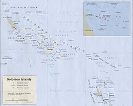
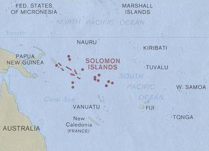
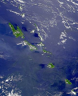
The Solomon Islands, also known simply as the Solomons, is a country consisting of six major islands and over 900 smaller islands in Melanesia, part of Oceania, to the northeast of Australia. It is directly adjacent to Papua New Guinea to the west, Australia to the southwest, New Caledonia and Vanuatu to the southeast, Fiji, Wallis and Futuna, and Tuvalu to the east, and Nauru and the Federated States of Micronesia to the north. It has a total area of 28,896 square kilometres, and a population of 734,887 according to the official estimates for mid 2023. Its capital and largest city, Honiara, is located on the largest island, Guadalcanal. The country takes its name from the wider area of the Solomon Islands archipelago, which is a collection of Melanesian islands that also includes the Autonomous Region of Bougainville, but excludes the Santa Cruz Islands.

<span class="mw-page-title-main">Pacific Remote Islands Marine National Monument</span> Group of unorganized United States Pacific Island territories

The Pacific Remote Islands Marine National Monument is a group of unorganized, mostly unincorporated United States Pacific Island territories managed by the United States Fish and Wildlife Service of the United States Department of the Interior and the National Oceanic and Atmospheric Administration (NOAA) of the United States Department of Commerce. These remote refuges are "the most widespread collection of marine- and terrestrial-life protected areas on the planet under a single country's jurisdiction". They protect many endemic species including corals, fish, shellfish, marine mammals, seabirds, water birds, land birds, insects, and vegetation not found elsewhere.

<span class="mw-page-title-main">Indispensable Reefs</span> Three atolls in Rennell and Bellona Province, Solomon Islands

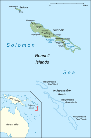
The Indispensable Reefs are a chain of three large coral atolls in the Coral Sea. They are located about 50 km (30 mi) south of Rennell Island. The chain stretches over a length of 114 km (71 mi) and its average width is 18 km (11 mi).

<span class="mw-page-title-main">Solomon Islands (archipelago)</span> Archipelago in the South Pacific spreading over two countries

The Solomon Islands (archipelago) is an island group in the western South Pacific Ocean, north-east of Australia. The archipelago is in the Melanesian subregion and bioregion of Oceania and forms the eastern boundary of the Solomon Sea. The many islands of the archipelago are distributed across the sovereign states of Papua New Guinea and Solomon Islands. The largest island in the archipelago is Bougainville Island, which is a part of the Autonomous Region of Bougainville along with Buka Island, the Nukumanu Islands, and a number of smaller nearby islands. Much of the remainder falls within the territory of Solomon Islands and include the atolls of Ontong Java, Sikaiana, the raised coral atolls of Bellona and Rennell, and the volcanic islands of Choiseul, Guadalcanal, Makira, Malaita, New Georgia, the Nggelas, Santa Isabel, and the Shortlands. The Santa Cruz Islands are not a part of the archipelago.

<span class="mw-page-title-main">Coral reefs of the Solomon Islands</span>

The Coral reefs of the Solomon Islands consists of six major islands and over 986 smaller islands, in Oceania, to the east of Papua New Guinea and northwest of Vanuatu. The Solomon Islands lie between latitudes 5° and 13°S, and longitudes 155° and 169°E. The distance between the westernmost and easternmost islands is about 1,500 km (930 mi). The Santa Cruz Islands are situated north of Vanuatu and are especially isolated at more than 200 km (120 mi) from the other islands. The Solomon Islands has the 22nd largest Exclusive Economic Zone of 1,589,477 km2 (613,701 sq mi) of the Pacific Ocean.

<span class="mw-page-title-main">Protected areas of Solomon Islands</span> Protected areas in Solomon Islands

Protected areas of Solomon Islands include marine protected areas that encompass coral reefs, lagoons, and seagrass meadows. East Rennell, which includes Lake Tegano, is the only area in the Solomon Islands listed by UNESCO as a World Heritage Site. As of April 2024, the Solomons have not nominated any wetlands under the Convention on Wetlands of International Importance.

References

  1. "Solomon Islands: Geography". CIA Factbook. Retrieved 25 July 2023.
  2. "Solomon Islands country profile". BBC News. 17 October 2023. Retrieved 17 October 2023.
  3. "Solomon Islands: Geography". CIA Factbook. Retrieved 25 July 2023.
  4. "Solomon Islands country profile". BBC News. 17 October 2023. Retrieved 17 October 2023.
  5. Turak, E. with Green, A., P. Lokani, W. Atu, P. Ramohia, P. Thomas and J. Almany (eds.). (2006). Solomon Islands Marine Assessment: Technical report of survey conducted May 13 to June 17, 2004. TNC Pacific Island Countries Report No. 1/06 (PDF) (Report). DC: World Resources Institute. pp. 65–109. Retrieved 31 March 2021.{{cite report}}: CS1 maint: multiple names: authors list (link)
  6. Doubilet, David (2007). Ultra Marine: In far eastern Indonesia, the Raja Ampat islands embrace a phenomenal coral wilderness. National Geographic, September 2007. Originally retrieved from http://ngm.nationalgeographic.com/2007/09/indonesia/doubilet-text. Archived on 2008-04-09 at https://web.archive.org/web/20080409084522/http://ngm.nationalgeographic.com/2007/09/indonesia/doubilet-text.
  7. "Klimatafel von Honiara / Insel Guadalcanal / Salomonen" (PDF). Baseline climate means (1961-1990) from stations all over the world (in German). Deutscher Wetterdienst. Archived (PDF) from the original on 12 May 2019. Retrieved 22 November 2016.
  8. "Weatherbase: Historical Weather for Yandina, Solomon Islands". Weatherbase. 2011. Retrieved on November 24, 2011.
  9. "Climate: Ghizo". Climate-Data.org. Retrieved 21 October 2020.
  10. "Solomon Islands: Geography". CIA Factbook. Retrieved 25 July 2023.
  11. "Solomon Islands country profile". BBC News. 17 October 2023. Retrieved 17 October 2023.

PD-icon.svg This article incorporates public domain material from The World Factbook. CIA.