Geology of North America

Last updated
USGS Geologic Map of North America (High resolution, click to zoom) USGS Geologic Map of North America.jpg
USGS Geologic Map of North America (High resolution, click to zoom)
Relief map showing the varying age of bedrock underlying North America. (Click to zoom) See legend below North america terrain 2003 map.jpg
Relief map showing the varying age of bedrock underlying North America. (Click to zoom) See legend below
This is the legend for the North American geological map above. North america terrain 2003 time scale.jpg
This is the legend for the North American geological map above.
Geologic map of North America World geologic provinces North America cropped.png
Geologic map of North America

The geology of North America is a subject of regional geology and covers the North American continent, the third-largest in the world. Geologic units and processes are investigated on a large scale to reach a synthesized picture of the geological development of the continent.

Contents

The divisions of regional geology are drawn in different ways, but are usually outlined by a common geologic history, geographic vicinity or political boundaries. The regional geology of North America usually encompasses the geographic regions of Alaska, Canada, Greenland, the continental United States, Mexico, Central America, and the Caribbean. [1] The parts of the North American Plate that are not occupied by North American countries are usually not discussed as part of the regional geology. The regions that are not geographically North American but reside on the North American Plate include parts of Siberia (see the Geology of Russia), [2] and Iceland, and Bermuda. A discussion of North American geology can also include other continental plates including the Cocos and Juan de Fuca plates being subducted beneath western North America. A portion of the Pacific Plate underlies Baja California and part of California west of the San Andreas Fault.

North American Craton

The stable core of the continent is the North American Craton. Much of it was also the core of an earlier supercontinent, Laurentia. [3] The part of the craton where the basement rock is exposed is called the Canadian Shield. Surrounding this is a stable platform where the basement is covered by sediment; and surrounding that are a series of orogenic zones.

Canadian Shield

On a map showing only metamorphic rocks, the Canadian Shield forms a circular pattern north of the Great Lakes around Hudson Bay. North america rock metamorphic.jpg
On a map showing only metamorphic rocks, the Canadian Shield forms a circular pattern north of the Great Lakes around Hudson Bay.

The Canadian Shield is a large area of Archean through Proterozoic igneous and metamorphic rocks in eastern Canada and north central and northeastern United States.

The earliest part of the shield is metamorphosed Archean rocks, originally volcanic in origin. Numerous terranes were accreted onto this Archean core during the Proterozoic to form the Canadian Shield. [4] The southern Archean province is the Superior Craton, it is formed by the combination of a greenstone-granite and a gneiss terrane. [5] The margins of the Canadian Shield have been covered by sedimentary rocks, such as in Michigan where a series of sediments has filled in the Michigan Basin. [4] The exposed sections are often where glaciers have removed this overlying regolith to reveal the underlying glacially scarred crystalline rock. [6]

Stable platform

The North American craton North america craton nps.gif
The North American craton

The stable platform is an area in which the North American Craton forms a basement and is covered by sediment. This area now forms much of the Interior Plains and the slope of the Appalachians below the mountains proper. [7] This area has been covered by a shallow inland sea, which became the site of deposition for most of the overlying sedimentary rock.[ citation needed ] The sea receded as the continent rose becoming covered by stream, lake, and wind deposits. [8] Orogenies in the surrounding provinces have had little effect on the craton, making it an epeirogenic region, [9] and, as such, the stable platform is mostly a crystalline basement, covered by sedimentary rocks, interrupted only by occasional domes, such as the Cincinnati Arch, Wisconsin Dome, and Ozark Dome. [7]

Midcontinent rift system

One billion years ago, the Midcontinent Rift System began to extend along a 2,000 kilometres (1,200 mi) path, [10] across both the Canadian Shield and the Stable Platform. The rift failed, then crustal movement reversed. A range formed then eroded, forming basins on either side of a horst. These rocks have been buried beneath sediment in many areas, but are exposed in some areas, especially around Lake Superior. [11]

Grenville Orogen

The Grenville Orogen developed during the Proterozoic along eastern and southern margin of the North American Craton. [12] [13] The largest outcrop of Grenville age rocks is an approximately 400 kilometres (250 mi) wide band southeast of the Grenville Front which stretches from the central Labrador coast southwest across southern Quebec and southeastern Ontario to Georgian Bay on Lake Huron. The southeastern boundary of this area is approximately the St. Lawrence River. Rocks of the Grenville outcrop in the Adirondack Mountains of northern New York and throughout the Appalachians. [13] The Llano Uplift of central Texas and the Franklin and Hueco Mountains of west Texas have been correlated with the Grenville as have occurrences in Mexico. [13]

Appalachian Orogen

Map of Appalachian geological provinces Appalachian map.svg
Map of Appalachian geological provinces

The fold and thrust belt of the Appalachians is continuously exposed for 2,000 kilometres (1,200 mi) from Pennsylvania to Alabama. [7] In the south, it extends under the coastal plain, but is covered by Mesozoic sediments. [14] North of this fold and thrust belt, the Acadian Orogen of the middle Devonian is an area where deformation has exposed granite plutons. [15] The center of the range is a pair of provinces running north and south parallel to each other, the eastern Blue Ridge Province and the western Valley and Ridge provinces. These are surrounded by the Appalachian Plateau on the west, and the Piedmont Province to the east. [16] Faulting extends throughout the region and is caused by numerous spatially and temporally varied sources. [17]

Inliers of Late Mesoproterozoic age are present on the west of the core of the Appalachians, and these inliers are associated with the Grenville orogeny. [18] During the Proterozoic terranes were accreted onto the province. [19] During the Taconic orogeny 445 to 435 million years ago, accretion continued, an island arc collided with the North American continent, and mountains were raised. These mountains slowly eroded and deposited sediment into the Catskill delta, stretching from New York to Pennsylvania. [20]

Piedmont

The eastern portion of the orogen is made up of the Piedmont plateau, a 150 to 300 metres (490 to 980 ft) elevation area composed of Paleozoic marine and volcanic sediments deformed into crystalline metamorphic rocks and intruded by granite domes. [21]

During the Proterozoic a series of terranes were accreted onto the North American craton, forming the Piedmont of the central Appalachians. [22] Following the Grenville orogeny, mountains eroded, and the sediments from this erosion were deposited below the mountains. [23] The bedrock of the plateau formed about 470 million years ago during the Taconic orogeny, when a volcanic island arc collided with the ancestral North American Continent. [24]

Passive Margin

As the Atlantic Ocean opened the Atlantic Coast turned from an active margin into a passive one. Terranes were no longer accreted onto the margin; instead, sediment eroded off the Appalachians began to be deposited on the coast, forming a coastal plain and continental shelf. [23] During the Jurassic and Triassic, marine and other sediment was deposited to form the Atlantic coastline. [25] The sediment has formed a clastic wedge making up most of the coastal plain and continental shelf. [23]

The passive margin of the Gulf of Mexico is a series of sedimentary deposits from upland areas surrounding the margin. The environment of deposition for these sediments has changed, varying spatially and temporally. When the ocean level was high shallow marine deposits occurred; when they were low fluvial and deltaic deposits form the majority of mass. [26] From the Triassic until the early Jurassic, faulting localized as extension faulting and wrench faulting. As the basement subsided, sediment accumulated, during the Mesozoic and Cenozoic, forming the modern wedge, containing salt basins. [27]

The passive margin in eastern Mexico is made up of a series of basins. These basins are mostly igneous or metamorphic rocks covered by sediments, [28] except in the Burgos Basin, where Cenozoic volcanism has occurred. [29] Much of the sediment is from erosion of the thrust belts west of the margin. [30]

The Yucatan Platform is a Cretaceous to Oligocene carbonate platform. Uplift started in the Oligocene and lasted till the Pleistocene. Today the platform is exposed and under the influence of karstification. [31]

North American Cordillera

On a map showing only volcanic rocks, the west coast of North America shows a striking continuous north-south structure, the American Cordillera. North america rock volcanic.jpg
On a map showing only volcanic rocks, the west coast of North America shows a striking continuous north–south structure, the American Cordillera.

The North American Cordillera extends up and down the coast of North America and roughly from the Great Plains westward to the Pacific Ocean, narrowing somewhat from north to south. It includes the Cascades, Sierra Nevada, and Basin and Range province; the Rocky Mountains are sometimes excluded from the cordillera proper, in spite of their tectonic history. The geology of Alaska is typical of that of the cordillera.

A rupture in Rodinia 750 million years ago formed a passive margin in the eastern Pacific Northwest. The breakup of Pangea 200 million years ago began the westward movement of the North American plate, creating an active margin on the western continent. As the continent drifted West, accretion of various terranes onto the west coast occurred. [32] As these accretions occurred, crustal shortening accompanied them during the Sevier orogeny and during the Mesozoic into the early Cenozoic, and was accompanied by faulting. [33] During the Cenozoic, crustal extension began accompanied by magmatism that came to characterize much of the area. [34]

Rocky Mountains

The Rocky Mountains were formed by a series of events, the last of which is the Laramide Orogeny. [35] One of the outstanding features of the Rocky Mountains is the distance of the range from a subducting plate; this has led to the theory that the Laramide Orogeny took place when the Farallon plate subducted at a low angle, causing uplift far from the margin under which the plate subducted. [36]

The lithology of the Rocky Mountains in western Canada includes a thin-skinned fold and thrust belt involving Neoproterozoic through Mississippian series of carbonates, shales, argillites and sandstones. [37]

The Colorado Plateau is a stable region dating back at least 600 million years. As a relative lowland, it had been a site of deposition for sediments eroded from surrounding mountain regions. [38] Then, during the Laramide Orogeny, the entire plateau was uplifted until about six million years ago. Erosion during and following the uplift removed sediment from the plateau. This load removal resulted in isostatic uplift and a second passive rise for the plateau. [39]

Intermontane Province

Cedar Breaks National Monument, Utah. Hoodoos in Cedar Breaks.jpeg
Cedar Breaks National Monument, Utah.

Between the Rocky Mountains and the coast ranges is an area dominated by extensional forces. The extension of this region has occurred both regionally and locally in events beginning in the Jurassic; however, most extension was localized until the mid Miocene. These local events occurred in the Jurassic, late Cretaceous, and one spanning from the Eocene until the Oligocene. Regional extension occurred during the middle of the Miocene from around 20 million years ago until 10 million years ago. [40]

The Basin and Range Province is a series of linear block fault mountains with adjacent sediment-filled downfaulted valleys, having been caused by crustal extension around 17 million years ago. The valley floors are made up of thick sediment deposits which have eroded off the mountains and filled the valleys, so that the region is a regular series of ridges spaced out by flat sediment valleys. [41]

Coast

On the West coast of North America, the coast ranges and the coastal plain form the margin, which is partially bounded by the San Andreas Fault, a transform boundary of the Pacific Plate. Most of the land is made of terranes that have been accreted onto the margin. In the north, the insular belt is an accreted terrane, forming the margin. This belt extends from the Wrangellia Terrane in Alaska to the Chilliwack group of Canada. [32]

The timing of the accretion of the insular belt is uncertain, although the closure did not occur until at least 115 million years ago. [32] Other Mesozoic terranes that accreted onto the continent include the Klamath Mountains, the Sierra Nevada, and the Guerrero super-terrane of western Mexico. [42] 80 to 90 million years ago the subducting Farallon plate split and formed the Kula Plate to the North. [32] Many of the major batholiths date from the late Cretaceous. [42] As the Laramide Orogeny ended around 48 million years ago, the accretion of the Siletzia terrane began in the Pacific Northwest. This began the volcanic activity in the Cascadia subduction zone, forming the modern Cascade Range, and lasted into the Miocene. As extension in the Basin and Range Province slowed by a change in North American Plate movement circa 7 to 8 Million years ago, rifting began on the Gulf of California. [43]

Southern Cordillera

The Sierra Madre mountain ranges of Mexico are separated by the Mexican Plateau, and transected by the Trans-Mexican Volcanic Belt. The Southern extent of the American Cordillera makes up Western Mexico and northern Central America. [44] This includes the Sierra Madre Occidental, the Sierra Madre del Sur, and the Trans-Mexican Volcanic Belt.

The Cordillera ends in the south in a belt of miogeoclines, including the Sierra Madre Oriental fold and thrust belt, the Mesa Central, and parts of the Sierra Madre del Sur. This belt also extends into Guatemala and Honduras in Central America. [44]

See also

Related Research Articles

<span class="mw-page-title-main">Orogeny</span> The formation of mountain ranges

Orogeny is a mountain-building process that takes place at a convergent plate margin when plate motion compresses the margin. An orogenic belt or orogen develops as the compressed plate crumples and is uplifted to form one or more mountain ranges. This involves a series of geological processes collectively called orogenesis. These include both structural deformation of existing continental crust and the creation of new continental crust through volcanism. Magma rising in the orogen carries less dense material upwards while leaving more dense material behind, resulting in compositional differentiation of Earth's lithosphere. A synorogenic process or event is one that occurs during an orogeny.

<span class="mw-page-title-main">Geology of the Appalachians</span> Geologic description of the Appalachian Mountains

The geology of the Appalachians dates back more than 1.2 billion years to the Mesoproterozoic era when two continental cratons collided to form the supercontinent Rodinia, 500 million years prior to the development of the range during the formation of Pangea. The rocks exposed in today's Appalachian Mountains reveal elongate belts of folded and thrust faulted marine sedimentary rocks, volcanic rocks, and slivers of ancient ocean floor—strong evidences that these rocks were deformed during plate collision. The birth of the Appalachian ranges marks the first of several mountain building plate collisions that culminated in the construction of Pangea with the Appalachians and neighboring Anti-Atlas mountains near the center. These mountain ranges likely once reached elevations similar to those of the Alps and the Rocky Mountains before they were eroded.

<span class="mw-page-title-main">Baltica</span> Late-Proterozoic to early-Palaeozoic continent

Baltica is a paleocontinent that formed in the Paleoproterozoic and now constitutes northwestern Eurasia, or Europe north of the Trans-European Suture Zone and west of the Ural Mountains. The thick core of Baltica, the East European Craton, is more than three billion years old and formed part of the Rodinia supercontinent at c.Ga.

<span class="mw-page-title-main">Acadian orogeny</span> North American orogeny

The Acadian orogeny is a long-lasting mountain building event which began in the Middle Devonian, reaching a climax in the Late Devonian. It was active for approximately 50 million years, beginning roughly around 375 million years ago (Ma), with deformational, plutonic, and metamorphic events extending into the early Mississippian. The Acadian orogeny is the third of the four orogenies that formed the Appalachian Mountains and subsequent basin. The preceding orogenies consisted of the Grenville and Taconic orogenies, which followed a rift/drift stage in the Neoproterozoic. The Acadian orogeny involved the collision of a series of Avalonian continental fragments with the Laurasian continent. Geographically, the Acadian orogeny extended from the Canadian Maritime provinces migrating in a southwesterly direction toward Alabama. However, the northern Appalachian region, from New England northeastward into Gaspé region of Canada, was the most greatly affected region by the collision.

<span class="mw-page-title-main">Taconic orogeny</span> Mountain-building period that affected most of New England

The Taconic orogeny was a mountain building period that ended 440 million years ago (Ma) and affected most of modern-day New England. A great mountain chain formed from eastern Canada down through what is now the Piedmont of the east coast of the United States. As the mountain chain eroded in the Silurian and Devonian periods, sediment spread throughout the present-day Appalachians and midcontinental North America.

<span class="mw-page-title-main">Grenville orogeny</span> Mesoproterozoic mountain-building event

The Grenville orogeny was a long-lived Mesoproterozoic mountain-building event associated with the assembly of the supercontinent Rodinia. Its record is a prominent orogenic belt which spans a significant portion of the North American continent, from Labrador to Mexico, as well as to Scotland.

<span class="mw-page-title-main">Geology of the Rocky Mountains</span> Discontinuous series of North American mountain ranges with distinct geological origin

The geology of the Rocky Mountains is that of a discontinuous series of mountain ranges with distinct geological origins. Collectively these make up the Rocky Mountains, a mountain system that stretches from Northern British Columbia through central New Mexico and which is part of the great mountain system known as the North American Cordillera.

<span class="mw-page-title-main">Trans-Hudson orogeny</span> Mountain-building event in North America

The Trans-Hudson orogeny or Trans-Hudsonian orogeny was the major mountain building event (orogeny) that formed the Precambrian Canadian Shield and the North American Craton, forging the initial North American continent. It gave rise to the Trans-Hudson orogen (THO), or Trans-Hudson Orogen Transect (THOT), which is the largest Paleoproterozoic orogenic belt in the world. It consists of a network of belts that were formed by Proterozoic crustal accretion and the collision of pre-existing Archean continents. The event occurred 2.0–1.8 billion years ago.

<span class="mw-page-title-main">Wyoming Craton</span> Craton in the west-central United States and western Canada

The Wyoming Craton is a craton in the west-central United States and western Canada – more specifically, in Montana, Wyoming, southern Alberta, southern Saskatchewan, and parts of northern Utah. Also called the Wyoming Province, it is the initial core of the continental crust of North America.

<span class="mw-page-title-main">Laurentia</span> Craton forming the geological core of North America

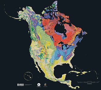
Laurentia or the North American Craton is a large continental craton that forms the ancient geological core of North America. Many times in its past, Laurentia has been a separate continent, as it is now in the form of North America, although originally it also included the cratonic areas of Greenland and the Hebridean Terrane in northwest Scotland. During other times in its past, Laurentia has been part of larger continents and supercontinents and consists of many smaller terranes assembled on a network of early Proterozoic orogenic belts. Small microcontinents and oceanic islands collided with and sutured onto the ever-growing Laurentia, and together formed the stable Precambrian craton seen today.

This is a list of articles related to plate tectonics and tectonic plates.

<span class="mw-page-title-main">Geology of Russia</span> Overview of the geology of Russia

The geology of Russia, the world's largest country, which extends over much of northern Eurasia, consists of several stable cratons and sedimentary platforms bounded by orogenic (mountain) belts.

<span class="mw-page-title-main">Geology of Massachusetts</span>

The geology of Massachusetts includes numerous units of volcanic, intrusive igneous, metamorphic and sedimentary rocks formed within the last 1.2 billion years. The oldest formations are gneiss rocks in the Berkshires, which were metamorphosed from older rocks during the Proterozoic Grenville orogeny as the proto-North American continent Laurentia collided against proto-South America. Throughout the Paleozoic, overlapping the rapid diversification of multi-cellular life, a series of six island arcs collided with the Laurentian continental margin. Also termed continental terranes, these sections of continental rock typically formed offshore or onshore of the proto-African continent Gondwana and in many cases had experienced volcanic events and faulting before joining the Laurentian continent. These sequential collisions metamorphosed new rocks from sediments, created uplands and faults and resulted in widespread volcanic activity. Simultaneously, the collisions raised the Appalachian Mountains to the height of the current day Himalayas.

<span class="mw-page-title-main">Tuareg Shield</span> Geological formation between the West African craton and the Saharan Metacraton in West Africa

The Tuareg Shield is a geological formation lying between the West African craton and the Saharan Metacraton in West Africa. Named after the Tuareg people, it has complex a geology, reflecting the collision between these cratons and later events. The landmass covers parts of Algeria, Niger and Mali.

<span class="mw-page-title-main">Geology of Colorado</span> Geology of the U.S. State of Colorado

The bedrock under the U.S. State of Colorado was assembled from island arcs accreted onto the edge of the ancient Wyoming Craton. The Sonoma orogeny uplifted the ancestral Rocky Mountains in parallel with the diversification of multicellular life. Shallow seas covered the regions, followed by the uplift current Rocky Mountains and intense volcanic activity. Colorado has thick sedimentary sequences with oil, gas and coal deposits, as well as base metals and other minerals.

<span class="mw-page-title-main">Geology of North Carolina</span>

The geology of North Carolina includes ancient Proterozoic rocks belonging to the Grenville Province in the Blue Ridge. The region experienced igneous activity and the addition of new terranes and orogeny mountain building events throughout the Paleozoic, followed by the rifting of the Atlantic Ocean and the deposition of thick sediments in the Coastal Plain and offshore waters.

The geology of Yukon includes sections of ancient Precambrian Proterozoic rock from the western edge of the proto-North American continent Laurentia, with several different island arc terranes added through the Paleozoic, Mesozoic and Cenozoic, driving volcanism, pluton formation and sedimentation.

<span class="mw-page-title-main">Mazatzal orogeny</span> Mountain-building event in North America

The Mazatzal orogeny was an orogenic event in what is now the Southwestern United States from 1650 to 1600 Mya in the Statherian Period of the Paleoproterozoic. Preserved in the rocks of New Mexico and Arizona, it is interpreted as the collision of the 1700-1600 Mya age Mazatzal island arc terrane with the proto-North American continent. This was the second in a series of orogenies within a long-lived convergent boundary along southern Laurentia that ended with the ca. 1200–1000 Mya Grenville orogeny during the final assembly of the supercontinent Rodinia, which ended an 800-million-year episode of convergent boundary tectonism.

<span class="mw-page-title-main">Yavapai orogeny</span> Mountain building event 1.7 billion years ago in the southwestern United States

The Yavapai orogeny was an orogenic (mountain-building) event in what is now the Southwestern United States that occurred between 1710 and 1680 million years ago (Mya), in the Statherian Period of the Paleoproterozoic. Recorded in the rocks of New Mexico and Arizona, it is interpreted as the collision of the 1800-1700 Mya age Yavapai island arc terrane with the proto-North American continent. This was the first in a series of orogenies within a long-lived convergent boundary along southern Laurentia that ended with the ca. 1200–1000 Mya Grenville orogeny during the final assembly of the supercontinent Rodinia, which ended an 800-million-year episode of convergent boundary tectonism.

References

  1. Dengo, Gabriel; Case, James E., eds. (1990). The Caribbean Region. Decade of North American Geology, Volume H (2nd ed.). Boulder: Geological Society of America. ISBN   9780813752129.
  2. Khain, Victor E. (1985). Geology of the USSR. Berlin: Gebr. Borntraeger. ISBN   978-3-443-11017-8.
  3. Stanley, Steven M. (2005). Earth system history (2nd ed.). New York: Freeman. pp. 290–292. ISBN   9780716739074.
  4. 1 2 "The Precambrian Era". Michigan State University. Retrieved 10 Mar 2013.
  5. Precambrian Geology of the Southern Canadian Shield and the Eastern Baltic Shield (PDF). USA-USSR-Canada Joint Seminar. Minnesota Geological Survey. 21–23 August 1990. Archived from the original (PDF) on 2013-12-03. Retrieved 10 Mar 2013.
  6. Larson, Phillip (2008). Quantification of Glacial Sediment Erosion, Entrainment, and Transport Processes and Their Implications for the Dynamic History of the Laurentide Ice Sheet (PDF) (Ph.D.). University of Minnesota. Archived from the original (PDF) on 2013-12-03.
  7. 1 2 3 Hamblin, W. Kenneth; Christiansen, Eric (2009). "23". Earth's Dynamic Systems (Web Edition 1.0 ed.). Retrieved 1 Mar 2013.
  8. Trimble, Donald (1980). "The Geologic Story of the Great Plains". Geological Survey Bulletin 1493. Archived from the original on 2013-03-20. Retrieved 11 Mar 2013.
  9. DiPietro, Joseph (2012). Landscape Evolution in the United States. Elsevier. ISBN   9780123978066 . Retrieved 15 Mar 2013.
  10. Bornhorst; Woodruff; Nicholson. "Stratigraphy, Structure, and Ore Deposits of the Southern Limb of the Midcontinent Rift System" . Retrieved 14 April 2013.
  11. Anderson, Raymond (1997). "The Midcontinent Rift: Iowa's Almost Ocean". Iowa Department of Natural Resources. Archived from the original on 1999-04-17. Retrieved 5 Mar 2013.
  12. "The Grenville".
  13. 1 2 3 Tollo, Richard P., et al., Proterozoic Tectonic Evolution of the Grenville Orogen in North America, Geological Society of America, 2004 ISBN   0813711975
  14. Thomas, William (1973). "Southwestern Appalachian Structural System Beneath the Gulf Coastal Plain" (PDF). American Journal of Science. 273: 372–390. Retrieved 5 Mar 2013.
  15. Dewey; Kidd (November 1974), "Continental Collisions in the Appalachian-Caledonian Orogenic Belt" (PDF), Geology, 2 (11): 543–546, doi:10.1130/0091-7613(1974)2<543:ccitao>2.0.co;2 , retrieved 5 Mar 2013
  16. Robert D. Leighty (August 31, 2001), "5.1.2 Valley and Ridge Physiographic Province", Automated IFSAR Terrain Analysis System (Final Report), US Army Aviation and Missile Command, archived from the original on June 26, 2013, retrieved May 9, 2013
  17. Hatcher, Robert; Odom; Engelder, Terry; Dunn; Wise; Geiser; Schamel, Steven; Kish (February 1988). "Characterization of Appalachian Faults" (PDF). Geology. 16 (2): 178–181. doi:10.1130/0091-7613(1988)016<0178:coaf>2.3.co;2 . Retrieved 14 April 2013.
  18. Tollo, Richard; Corriveau, Louise; McLelland, James; Bartolomew, Mervin (2004), Proterozoic tectonic evolution of the Grenville orogen in North America, ISBN   9780813711973 , retrieved 8 Mar 2013
  19. Levin, Vadim; Park, Jeffrey; Brandon, Mark; Menke, William (2000). "Thinning of the upper mantle during late Paleozoic Appalachian orogenesis". Geology. 28 (3): 239–242. doi:10.1130/0091-7613(2000)28<239:totumd>2.0.co;2 . Retrieved 8 Mar 2013.
  20. Tagg, John P. "Building the Appalachian Mountains". Archived from the original on 19 September 2014. Retrieved 5 May 2013.
  21. Aber, James (2001). "Appalachian Mountains". Archived from the original on 18 May 2013. Retrieved 5 Mar 2013.
  22. Drake, Avery; Brezinski, David; Wintsch, Robert; Kunk, Michael; Aleinkoff, John; Naeser (2006). "Central Appalachian Piedmont and Blue Ridge tectonic transect, Potomac River corridor" (PDF). Geological Society of America. Archived from the original (PDF) on 2013-02-18. Retrieved 10 Mar 2013.
  23. 1 2 3 Stoffer, Phil; Messina, Paula (1996). "The Atlantic Coastal Plain" . Retrieved 10 Mar 2013.
  24. Geology of the Southern Appalachian Mountains (Map). USGS. Retrieved 5 Mar 2013.
  25. Hanner, Charlie; Davis, Susan; Brewer, James (2006). "Central Appalachian Piedmont and Blue Ridge tectonic transect, Potomac River corridor" (PDF). USDA Resources Conservation Service. Archived from the original (PDF) on 2012-10-21. Retrieved 10 Mar 2013.
  26. Grubb, Hayes; Carillo, J. Joel. (1988). "Chapter 26: Region 23, Gulf of Mexico Coastal Plain". In Back, William; Rosenshein, Joseph; Seaber, Paul (eds.). The Geology of North America. The Geological Society of America. pp. 219–228. Retrieved 28 Feb 2013.
  27. Mancini, Ernest; Obid, Jamal; Badali, Marcello; Liu, Kaiyu; Parcell, William (December 2008). "Sequence-stratigraphic analysis of Jurassic and Cretaceous strata and petroleum exploration in the central and eastern Gulf coastal plain, United States". AAPG Bulletin. 92 (12): 1655–1686. doi:10.1306/08130808046. Archived from the original on 21 April 2014. Retrieved 28 Feb 2013.
  28. Humapa. 2012. Archived from the original on 4 March 2016. Retrieved 27 Jan 2013.
  29. Cruz, Guillermo (1993). Geological evolution of the Burgos Basin, northeastern Mexico (Thesis). hdl:1911/16657.
  30. Hickman, Robert; Cuervo, Arturo; Valdivieso, Victor; Caraveo, Carlos; Rivera, Sergio; Espinoza, Miguel; Cuevas, Marie; Ghosh, Santosh; Kroener, Robert; Marrullier, Carl (Oct 2002). "Geology and Exploration Potential of the Veracruz Basin". Houston Geological Society Bulletin. 45 (2): 15, 17.
  31. "A Condensed Geological Chronicle of the Yucatan Platform" . Retrieved 17 January 2013.
  32. 1 2 3 4 Townsend, Catherine; Figge, John (2002). "Northwest Origins". The Burke Museum.
  33. Bendick, Rebecca; Baldwin, Julia (2009). "Dynamic models for metamorphic core complex formation and scaling" (PDF). Tectonophysics. 477 (1–2): 93–101. doi:10.1016/j.tecto.2009.03.017. Archived from the original (PDF) on 26 November 2013. Retrieved 19 April 2013.
  34. Liu, Mian (2001). "Cenozoic extension and magmatism in the North American Cordillera" (PDF). Tectonophysics. 342 (3–4): 407–433. doi:10.1016/s0040-1951(01)00173-1. Archived from the original (PDF) on 3 March 2016. Retrieved 19 April 2013.
  35. English, Joseph; Johnston, Stephen; Wang, Kelin. "Thermal modelling of the Laramide orogeny" (PDF). Archived from the original (PDF) on 2013-12-03. Retrieved 2013-03-01.{{cite journal}}: Cite journal requires |journal= (help)
  36. Bunge, Hans-Peter; Grand, Stephen (18 May 2000). "Mesozoic plate-motion history below the Pacific Ocean from seismic images of the subducted Farallon slab". Nature. 405 (6784): 337–340. doi:10.1038/35012586. PMID   10830960. S2CID   4405770.
  37. McMechan, Margot; Macey, Elizabeth. Geology of the Rocky Mountains west of Calgary, Alberta in the Kananaskis west half map area (PDF). GeoConvention 2012:Vision. Archived from the original (PDF) on 6 June 2014. Retrieved 15 May 2013.
  38. Foos, Annabelle. "Geology of the Colorado Plateau" (PDF). Archived from the original (PDF) on 8 September 2015. Retrieved 5 March 2013.
  39. Hanson, Erik (2009). "The Grand Canyon". Canyons . Infobase Publishing. ISBN   978-0816064359.
  40. Gans, Phillip; Miller, Elizabeth (1993). "Extension of the Basin and Range Province" . Retrieved 15 Mar 2013.
  41. "Geologic Provinces of the United States:Basin and Range Province". US Department of the Interior. 13 Jan 2004. Archived from the original on 25 January 2009. Retrieved 15 Mar 2013.
  42. 1 2 Dickinson, William (2004). "Evolution of the North American Cordillera" (PDF). Annual Review of Earth and Planetary Sciences. 32 (1): 13–45. doi:10.1146/annurev.earth.32.101802.120257. Archived from the original (PDF) on 4 January 2014. Retrieved 9 April 2013.
  43. Humphreys, Eugene (2009). "Relation of flat subduction to magmatism and deformation in the Western United States". GSA.{{cite journal}}: Cite journal requires |journal= (help)
  44. 1 2 King, Philip (1969). The Tectonics of North America (PDF). USGS Professional Paper 628. p. 49.

Further reading