Gordon Dam

Last updated

Gordon Dam
Gordon Dam.jpg
The double arch wall of Gordon Dam holding back Lake Gordon
Relief Map of Tasmania.png
Red pog.svg
Location in Tasmania
CountryAustralia
Location South West Tasmania
Coordinates 42°43′50″S145°58′35″E / 42.73056°S 145.97639°E / -42.73056; 145.97639
Purpose Power
StatusOperational
Construction began1964 (1964)
Opening date1978 (1978)
Owner(s) Hydro Tasmania
Dam and spillways
Type of dam Arch dam
Impounds Gordon River
Height140 m (459 ft)
Length198 m (650 ft)
Elevation at crest310 m above sea level
Width (crest)2.75 m (9 ft)
Width (base)17.7 m (58 ft)
Dam volume154×10^3 m3 (5×10^6 cu ft)
Spillways no spillway on Lake Gordon, spill is via Lake Pedder at serpentine dam (250 cubic meters/second)
Spillway type Controlled
Reservoir
Creates Lake Gordon
Total capacity12.4 km3 (3.0 cu mi)
Catchment area 1,280 km2 (494 sq mi)
Surface area278 km2 (107 sq mi)
Gordon Power Station
Coordinates 42°43′48″S145°58′12″E / 42.73000°S 145.97000°E / -42.73000; 145.97000
Operator(s) Hydro Tasmania
Commission date1978; 1988
Type Conventional
Turbines 3 Fuji x 144 MW (193,107 hp)
Installed capacity 432 to 450 MW (579,322 to 603,460 hp)
Capacity factor 0.9
Annual generation 1,388 GWh (4,997 TJ)
Website
hydro.com.au
[1]

The Gordon Dam, also known as the Gordon River Dam, is a major gated double curvature concrete arch dam with a controlled spillway across the Gordon River, located in Southwest National Park, Tasmania, Australia. The impounded reservoir is called Lake Gordon.

Contents

The dam was constructed in 1974 by the Hydro Electric Corporation (TAS) for the purpose of generating hydro-electric power via the conventional Gordon Power Station located below the dam wall. [1] [2]

Features and location

The Gordon Dam wall, constructed with 154 thousand cubic metres (5.4×10^6 cu ft) of concrete, is 198 metres (650 ft) long and 140 metres (460 ft) high, making it the tallest dam in Tasmania and the fifth-tallest in Australia. [3] At 100% capacity the dam wall holds back 12,359,040 thousand cubic metres (436,455×10^6 cu ft) of water; making Lake Gordon the largest lake in Australia. [4] The surface area of the lake is 27,800 hectares (69,000 acres) and the catchment area is 2,014 square kilometres (778 sq mi). The single controlled spillway is capable of discharging 175 cubic metres per second (6,200 cu ft/s). [1]

Approximately 48 arch dams have been built in Australia and only nine have double curvature. Gordon Dam is almost twice the height of the next highest arch dam, Tumut Pondage. [4] :5–6

Power station

Water from the dam descends 183 metres (600 ft) underground into its power station, where three turbines of 144 megawatts (193,000 hp) generate up to 432 megawatts (579,000 hp) of power, covering about 13% of the electricity demand of Tasmania. [5] The first two turbines were commissioned in 1978, before the third was commissioned a decade later in 1988. [6]

The power station is fueled by water from Lake Gordon. Water from Lake Pedder is also drawn into Lake Gordon through the McPartlans Pass Canal at 42°50′51″S146°11′45″E / 42.84750°S 146.19583°E / -42.84750; 146.19583 (McPartlans Pass Canal) .

History

In 1963, the Australian Government provided an A$5 million grant to Tasmania's Hydro-Electric Commission to build the Gordon River Road from Maydena into the Gordon River area in the South West Wilderness region. [7] Construction was underway by 1964, and within three years, the Tasmanian State Parliament approved the Gordon River Power Development with little in house opposition in 1967. Power operation began in 1978, a third generator was added in 1988.

The completed Gordon Dam was the only dam built on the Gordon River, despite the support of Tasmanian politicians such as Eric Reece, Robin Gray, and others to build the Franklin Dam further downstream. The construction of Gordon Dam resulted in some flooding of the connected Lake Pedder as planned. Subsequent opposition to restore Lake Pedder failed after a Parliamentary inquiry in 1995. [8]

The dam was designed with Dr. Sergio Guidici as the chief engineer. He went on to be involved with the design of the Crotty Dam in the West Coast Range, one of the last significant dams created by Hydro Tasmania during its unabated dam-building era.

The dam is connected with the Gordon River Power Station, 183 metres (600 ft) under the surface of the switch yard. [9]

In 2015, the Perth-based YouTube channel How Ridiculous broke the world record for the world's highest basketball shot at Gordon dam, though this record has since been surpassed by How Ridiculous themselves twice over. [10]

20152016 Tasmanian energy crisis

Due to an extreme drought in 2015 and the untimely failure of the related Basslink power feed, electricity production needs had drained the lake to its minimum operating level in March 2016. [11] [12] The water level fell 45 metres to a record low of six per cent capacity. [13] Pictures document the dramatic effect. [13] [14] After repair of Basslink and record rainfalls, Lake Gordon levels had recovered to -28 metres by January 2017. [11] [15]

Engineering heritage award

The dam is listed as a National Engineering Landmark by Engineers Australia as part of its Engineering Heritage Recognition Program. [16]

See also

Gordon Dam bridge
Coordinates 42°43′49″S145°58′35″E / 42.7303°S 145.9764°E / -42.7303; 145.9764
Carries Pedestrians [17]
Characteristics
Width2.7 metres (8 ft 10 in)
Location
Gordon Dam

Related Research Articles

<span class="mw-page-title-main">Lake Pedder</span> Lake in South West Tasmania, Australia

Lake Pedder, once a glacial outwash lake, is a man-made impoundment and diversion lake located in the southwest of Tasmania, Australia. In addition to its natural catchment from the Frankland Range, the lake is formed by the 1972 damming of the Serpentine and Huon rivers by the Hydro Electric Commission of Tasmania for the purposes of hydroelectric power generation.

<span class="mw-page-title-main">Lake Gordon</span> Reservoir in Tasmania, Australia

Lake Gordon is a man-made reservoir created by the Gordon Dam, located on the upper reaches of the Gordon River in the south-west region of Tasmania, Australia.

<span class="mw-page-title-main">Gordon River</span> River in Tasmania, Australia

The Gordon River is a major perennial river located in the central highlands, south-west, and western regions of Tasmania, Australia.

<span class="mw-page-title-main">Hydro Tasmania</span> Government hydro electricity provider in Tasmania, Australia

Hydro Tasmania, known for most of its history as the Hydro-Electric Commission (HEC) or The Hydro, is the trading name of the Hydro-Electric Corporation, a Tasmanian Government business enterprise which is the predominant electricity generator in the state of Tasmania, Australia. The Hydro was originally oriented towards hydro-electricity, due to Tasmania's dramatic topography and relatively high rainfall in the central and western parts of the state. Today Hydro Tasmania operates thirty hydro-electric and one gas power station, and is a joint owner in three wind farms.

The Great Lake, officially yingina / Great Lake, is a natural lake and man-made reservoir that is located in the central northern region of Tasmania, Australia.

The Lake Margaret Power Stations comprise two hydroelectric power stations located in Western Tasmania, Australia. The power stations are part of the King – Yolande Power Scheme and are owned and operated by Hydro Tasmania. Officially the Upper Lake Margaret Power Station, a conventional hydroelectric power station, and the Lower Lake Margaret Power Station, a mini-hydroelectric power station, the stations are generally collectively referred to in the singular format as the Lake Margaret Power Station. The stations are located approximately 2.5 kilometres (1.6 mi) apart.

<span class="mw-page-title-main">Crotty Dam</span> Dam in Western Tasmania, Australia

The Crotty Dam, also known during construction as the King Dam, or the King River Dam on initial approval, is a rockfill embankment dam with a controlled and uncontrolled spillway across the King River, between Mount Jukes and Mount Huxley, located in Western Tasmania, Australia.

<span class="mw-page-title-main">Meadowbank Power Station</span> Power station in Tasmania, Australia

The Meadowbank Power Station is a run-of-the-river hydroelectric power station located in the Central Highlands region of Tasmania, Australia. The power station is situated on the Lower River Derwent catchment and is owned and operated by Hydro Tasmania.

The Rowallan Power Station is a conventional hydroelectric power station located in north-western Tasmania, Australia. The station is located 25 kilometres (16 mi) south of Liena.

<span class="mw-page-title-main">Devils Gate Power Station</span> Dam in North-western Tasmania

The Devils Gate Power Station is a conventional hydroelectric power station located in north-western Tasmania, Australia. The dam is 84 metres (276 ft) high. It is one of the thinnest concrete arch dams in the world.

<span class="mw-page-title-main">Gordon Power Station</span> Power station in Tasmania, Australia

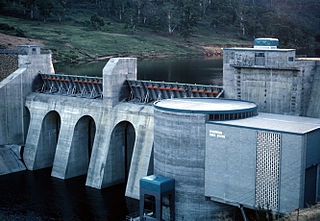
The Gordon Power Station is the largest conventional hydroelectric power station in Tasmania, Australia; located in the South West region of the state. The power station is situated on Gordon River. Water from Lake Gordon descends 183 metres (600 ft) underground past the Gordon Dam and into the power station.

The Moorina Power Station is a decommissioned hydroelectric power station, located near the hamlet of Moorina in far north-eastern Tasmania, Australia. Opened in 1909 and decommissioned in 2008, at the time of its closure, Moorina Power Station was the oldest operating electricity generator in Australia.

The Gordon River Road, sometimes called the Strathgordon Road, (B61), is a road in the south western region of Tasmania, Australia.

The Scotts Peak Dam is a rockfill embankment dam without a spillway across the Huon River, located in the South West region of Tasmania, Australia.

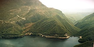
The Serpentine Dam is a rockfill embankment dam with a concrete face and a controlled spillway across the Serpentine River, located in the South West region of Tasmania, Australia.

The Edgar Dam is an earthfill embankment saddle dam without a spillway, located offstream in the South West region of Tasmania, Australia.

The Anthony Power Development Scheme, part of the Pieman River power development scheme, was a proposed scheme for damming parts of the upper catchment of the Pieman River in Western Tasmania, Australia.

The Meander Dam is a concrete gravity dam across the Upper Meander River, located in northern Tasmania, Australia. The impounded reservoir is called Lake Huntsman.

The John Butters Power Station is a conventional hydroelectric power station located in Western Tasmania, Australia. The power station forms part of the King – Yolande River Power Scheme and is owned and operated by Hydro Tasmania.

Pieman River Power Development was a major 1970s and 1980s hydroelectric development of the Pieman River and its tributaries on the west coast of Tasmania.

References

  1. 1 2 3 "Register of Large Dams in Australia". Dams information. Australian National Committee on Large Dams. 2010. Archived from the original (Excel (requires download)) on 12 December 2013. Retrieved 23 June 2015.
  2. "Gordon Power Station Fact Sheet: Technical fact sheet" (PDF). Energy: Our power stations. Hydro Tasmania. Archived from the original (PDF) on 24 March 2012. Retrieved 16 January 2015.
  3. "Australia's Highest Dams" (PDF). The Australian National Committee on Large Dams Incorporated. Archived from the original (PDF) on 6 July 2011. Retrieved 7 April 2008. The five tallest dams listed in order of decreasing height are: Dartmouth Dam, 180 metres (590 ft), Victoria; Thomson River Dam, 166 metres (545 ft), Victoria; Talbingo Dam, 162 metres (531 ft), NSW; Warragamba Dam, 142 metres (466 ft), NSW; Gordon Dam, 140 metres (460 ft), Tasmania
  4. 1 2 "Gordon Dam, Tasmania: Submission for an National Engineering Landmark" (PDF). Engineers Australia. September 2000. Retrieved 23 July 2017.
  5. "The Gordon Catchment". Hydro Tasmania.[ permanent dead link ]
  6. "Gordon Dam: National Engineering Landmark" (plaque). Engineers Australia. Retrieved 22 June 2015.
  7. Thompson, Peter (1981). Power In Tasmania. Australian Conservation Foundation. p. 19. ISBN   0-85802-064-5.
  8. "Gordon - Pedder Energy". www.hydro.com.au. Hydro Tasmania. Retrieved 8 February 2017.
  9. Townsend, Clif (14 June 2015). "The Gordon River Underground Power Station". Hyrdo 100. Hydro Tasmania. Retrieved 15 June 2015.
  10. https://www.youtube.com/watch?v=H9SF2YIKRY8 WORLD RECORD Basketball Shot 126.5m (415 ft) - How Ridiculous
  11. 1 2 "What caused the 2015/16 energy challenge in Tasmania?". www.hydro.com.au. Hydro Tasmania. Archived from the original on 27 June 2016. Retrieved 8 February 2017.
  12. Denholm, Matthew (15 March 2016). "Fighting to keep Tasmania's lights on in energy crisis". The Australian. Retrieved 8 February 2017.
  13. 1 2 Gramenz, Emilie (31 March 2016). "Tasmanian energy crisis: Lake Gordon dam level fall captured in dramatic video". News. Australian Broadcast Corp. Retrieved 7 February 2017.
  14. AAP (29 March 2016). "Stark images reveal dire state of falling water level". Mercury. Retrieved 8 February 2017.
  15. "Lake Gordon at Intake" (PDF). www.hydro.com.au. Hydro Tasmania. Archived from the original (PDF) on 11 February 2017. Retrieved 8 February 2017.
  16. "Gordon Dam, Gordon River, 1974-". Engineers Australia. Retrieved 27 April 2020.
  17. "Southwest National Park". Archived from the original on 7 June 2010. Retrieved 21 May 2009.