
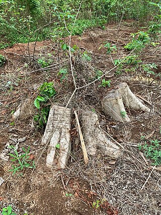
Deforestation or forest clearance is the removal and destruction of a forest or stand of trees from land that is then converted to non-forest use. Deforestation can involve conversion of forest land to farms, ranches, or urban use. About 31% of Earth's land surface is covered by forests at present. This is one-third less than the forest cover before the expansion of agriculture, with half of that loss occurring in the last century. Between 15 million to 18 million hectares of forest, an area the size of Bangladesh, are destroyed every year. On average 2,400 trees are cut down each minute. Estimates vary widely as to the extent of deforestation in the tropics. In 2019, nearly a third of the overall tree cover loss, or 3.8 million hectares, occurred within humid tropical primary forests. These are areas of mature rainforest that are especially important for biodiversity and carbon storage.
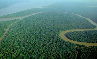
A forest is an ecosystem characterized by a dense community of trees. Hundreds of definitions of forest are used throughout the world, incorporating factors such as tree density, tree height, land use, legal standing, and ecological function. The United Nations' Food and Agriculture Organization (FAO) defines a forest as, "Land spanning more than 0.5 hectares with trees higher than 5 meters and a canopy cover of more than 10 percent, or trees able to reach these thresholds in situ. It does not include land that is predominantly under agricultural or urban use." Using this definition, Global Forest Resources Assessment 2020 found that forests covered 4.06 billion hectares, or approximately 31 percent of the world's land area in 2020.

Reforestation is the practice of restoring previously existing forests and woodlands that have been destroyed or damaged. The prior forest destruction might have happened through deforestation, clearcutting or wildfires. Two important purposes of reforestation programs are for harvesting of wood or for climate change mitigation purposes. Reforestation can also help with ecosystem restoration. One method for reforestation is to establish tree plantations, also called plantation forests. They cover about 131 million ha worldwide, which is 3 percent of the global forest area and 45 percent of the total area of planted forests.
This is an index of conservation topics. It is an alphabetical index of articles relating to conservation biology and conservation of the natural environment.
Habitat destruction occurs when a natural habitat is no longer able to support its native species. The organisms once living there have either moved to elsewhere or are dead, leading to a decrease in biodiversity and species numbers. Habitat destruction is in fact the leading cause of biodiversity loss and species extinction worldwide.
The Mesoamerican Biological Corridor (MBC) is a region that consists of Belize, Guatemala, El Salvador, Honduras, Nicaragua, Costa Rica, Panama, and some southern states of Mexico. The area acts as a natural land bridge from South America to North America, which is important for species who use the bridge in migration. Due to the extensive unique habitat types, Mesoamerica contains somewhere between 7 and 10% of the world’s known species.
Environmental issues in Bolivia include deforestation caused by commercial agriculture, urbanization, and illegal logging, and biodiversity loss attributed to illegal wildlife trade, climate change, deforestation, and habitat destruction. Since 1990, Bolivia has experienced rapid urbanization raising concerns about air quality and water pollution.

Environmentally, Colombia is a mega-diverse country from its natural land terrain to its biological wildlife. Its biodiversity is a result of its geographical location and elevation. It is the fourth largest South American country and only country in South America to have coasts on the Pacific and Caribbean Sea. Colombia's terrain can be divided into six main natural zones: The Caribbean, the Pacific, The Orinoco region, The Amazonia region, the Andean region, and the Insular region. 52.2% of the environment is predominately the Andes, Amazon, and Pacific Basins, followed by the Orinoco basin 13.9%, the Andes and the Caribbean. The Tropical Andes, Choco, and the Caribbean are considered biodiversity hotspots which puts these areas at high risk of concentration of colonizing activities. Colombia host over 1800 bird species and at least one new species are detected every year. Decades of civil war and political unrest have impeded biological and environmental research in Colombia. The political unrest in Colombia catalyzes the alteration of land patterns through the cultivation of coca and opium crops, the redirection of extractive activities, and land abandonment in some areas.

The Alto Mayo Protection Forest is an area of protected forest land in northern Peru. It is located in Rioja and Moyobamba provinces within the region of San Martin, with a small part in Rodriguez de Mendoza province, in the region of Amazonas. This area preserves a portion of the tropical yungas forest in the upper Mayo River basin, while protecting soil and water from erosion by deforestation, as the area is the water supply of populations in the Mayo valley.
Since declaring independence in 1981, Belize has enacted many environmental protection laws aimed at the preservation of the country's natural and cultural heritage, as well as its wealth of natural resources. These acts have established a number of different types of protected areas, with each category having its own set of regulations dictating public access, resource extraction, land use and ownership.

Deforestation in Ethiopia is due to locals clearing forests for their personal needs, such as for fuel, hunting, agriculture, and sometimes religious reasons. The main causes of deforestation in Ethiopia are shifting agriculture, livestock production and fuel in drier areas. Deforestation is the process of removing the forest ecosystem by cutting the trees and changing the shape of the land to suit different uses.
Deforestation in Nigeria refers to the extensive and rapid clearing of forests within the borders of Nigeria. This environmental issue has significant impacts on both local and global scales.

Deforestation is a major threat to biodiversity and ecosystems in Costa Rica. The country has a rich biodiversity with some 12,000 species of plants, 1,239 species of butterflies, 838 species of birds, 440 species of reptiles and amphibians, and 232 species of mammals, which have been under threat from the effects of deforestation. Agricultural development, cattle ranching, and logging have caused major deforestation as more land is cleared for these activities. Despite government efforts to mitigate deforestation, it continues to cause harm to the environment of Costa Rica by impacting flooding, soil erosion, desertification, and loss of biodiversity.

Deforestation is one of the most serious environmental issues in Sri Lanka. Sri Lanka's current forest cover as of 2017 was 29.7%. In the 1920s, the island had a 49 percent forest cover but by 2005 this had fallen by approximately 26 percent. Between 1990 and 2000, Sri Lanka lost an average of 26,800 ha of forests per year. This amounts to an average annual deforestation rate of 1.14%. Between 2000 and 2005 the rate accelerated to 1.43% per annum. However, with a long history of policy and laws towards environmental protection, deforestation rates of primary cover have decreased 35% since the end of the 1990s thanks to a strong history of conservation measures. The problem of deforestation in Sri Lanka is not as significant in the southern mountainous regions as it is in northern and lowland southern Sri Lanka, largely due to the nature of environmental protection.

Deforestation in Madagascar is an ongoing environmental issue. Deforestation creates agricultural or pastoral land but can also result in desertification, water resource degradation, biodiversity erosion and habitat loss, and soil loss.

Central American countries have experienced cycles of deforestation and reforestation since the decline of Maya civilization, influenced by many factors such as population growth, agriculture, narcotic distribution and illegal practices. From 2001 to 2010, 5,376 square kilometres (2,076 sq mi) of forest were lost in the region. In 2010 Belize had 63% of remaining forest cover, Costa Rica 46%, Panama 45%, Honduras 41%, Guatemala 37%, Nicaragua 29%, and El Salvador 21%. Most of the loss occurred in the moist forest biome, with 12,201 square kilometers. Woody vegetation loss was partially set off by a plus in the coniferous forest biome with 4,730 km2, and at 2,054 km2. Mangroves and deserts contributed only 1% to the loss in forest vegetation. The bulk of the deforestation was located at the Caribbean slopes of Nicaragua with a minus of 8,574 square kilometers of forest lost in the period from 2001 to 2010. The most significant regrowth of 3,050 km2 of forest was seen in the coniferous woody vegetation of Honduras.

Forest restoration is defined as “actions to re-instate ecological processes, which accelerate recovery of forest structure, ecological functioning and biodiversity levels towards those typical of climax forest” i.e. the end-stage of natural forest succession. Climax forests are relatively stable ecosystems that have developed the maximum biomass, structural complexity and species diversity that are possible within the limits imposed by climate and soil and without continued disturbance from humans. Climax forest is therefore the target ecosystem, which defines the ultimate aim of forest restoration. Since climate is a major factor that determines climax forest composition, global climate change may result in changing restoration aims. Additionally, the potential impacts of climate change on restoration goals must be taken into account, as changes in temperature and precipitation patterns may alter the composition and distribution of climax forests.
Climate change in Mexico is expected to have widespread impacts: with significant decreases in precipitation and increases in temperatures. This will put pressure on the economy, people and the biodiversity of many parts of the country, which have largely arid or hot climates. Already climate change has impacted agriculture, biodiversity, farmer livelihoods, and migration, as well as water, health, air pollution, traffic disruption from floods, and housing vulnerability to landslides.

Although the conservation movement developed in Europe in the 18th century, Costa Rica as a country has been heralded its champion in the current times. Costa Rica hosts an astonishing number of species, given its size, having more animal and plant species than the US and Canada combined hosting over 500,000 species of plants and animals. Despite this, Costa Rica is only 250 miles long and 150 miles wide. A widely accepted theory for the origin of this unusual density of species is the free mixing of species from both North and South America occurring on this "inter-oceanic" and "inter-continental" landscape. Preserving the natural environment of this fragile landscape, therefore, has drawn the attention of many international scholars and scientists.

The Niger Delta swamp forests is a tropical moist forest ecoregion in southern Nigeria. It consists of freshwater swamp forests in the Niger Delta of the Niger River. This swamp forest is the second largest in Africa after the Congolian swamp forests. Although there are large cities just outside the ecoregion, the area has been relatively isolated by the difficulty of building roads across the swamps, although this is changing with development of oil and logging industries. Scientific surveys have only begun in recent years, and new species were being identified into the 1990s. Crude oil exploration and pollution has been a threat to forests in the Niger Delta region.

