List of lakes of Guatemala

Last updated

This is a list of lakes in Guatemala.

Lakes

NameArea (km²)Max. depth (m)CoordinatesAltitude (m)DepartmentMunicipality
Laguna de Ayarza 14230 14°25′N90°7′W / 14.417°N 90.117°W / 14.417; -90.117 (Laguna de Ayarza) 1409 Santa Rosa Casillas
Laguna de Calderas 0.1120 14°24′40″N90°35′25″W / 14.41111°N 90.59028°W / 14.41111; -90.59028 (Laguna de Calderas) 1778 Guatemala San Vicente Pacaya
Lago Atitlán 130340 14°42′N91°12′W / 14.700°N 91.200°W / 14.700; -91.200 (Lago Atitlán) 1562 Sololá Santiago Atitlán
Lago de Guija 45430 14°15′N89°32′W / 14.250°N 89.533°W / 14.250; -89.533 (Lago de Guija) 430 Jutiapa, Santa Ana Asunción Mita
Laguna de Chicabal 0.22331 14°47′N91°40′W / 14.783°N 91.667°W / 14.783; -91.667 (Laguna de Chicabal) 2712 Quetzaltenango San Martín Sacatepéquez
Laguna Nisguaya 0.562 13°54′30″N90°11′50″W / 13.90833°N 90.19722°W / 13.90833; -90.19722 (Laguna Nisguaya) 35 Jutiapa Pasaco
Laguneta El Tule 0.302 13°51′10″N90°7′50″W / 13.85278°N 90.13056°W / 13.85278; -90.13056 (Laguneta El Tule) 89 Jutiapa Moyuta
Laguna de Ipala 0.5925 14°33′20″N89°38′20″W / 14.55556°N 89.63889°W / 14.55556; -89.63889 (Laguna de Ipala) 1493 Chiquimula Ipala
Laguna El Pino 0.7218 14°20′40″N90°23′38″W / 14.34444°N 90.39389°W / 14.34444; -90.39389 1022 Santa Rosa Barberena
Laguna de Ixpaco 14°15′00″N90°25′00″W / 14.25000°N 90.41667°W / 14.25000; -90.41667 750 Santa Rosa Barberena
Lago de Amatitlán 15.2033 14°28′N90°36′W / 14.467°N 90.600°W / 14.467; -90.600 (Lago de Amatitlán) 1188 Guatemala Amatitlán
Lago de Izabal 589.618 15°24′2″N89°10′0″W / 15.40056°N 89.16667°W / 15.40056; -89.16667 (Lago de Izabal) 2 Izabal El Estor
Laguneta Bujajal 8.24 15°26′15″N89°22′30″W / 15.43750°N 89.37500°W / 15.43750; -89.37500 (Laguneta Bujajal) 2 Izabal El Estor
Laguneta el Amatillo 1.405 15°46′50″N89°21′40″W / 15.78056°N 89.36111°W / 15.78056; -89.36111 (Laguneta el Amatillo) 11 Izabal El Estor
Laguna el Temblor 0.35 15°24′10″N89°36′20″W / 15.40278°N 89.60556°W / 15.40278; -89.60556 (Laguna el Temblor) 9 Alta Verapaz Panzós
Laguna Lachuá 4222 15°55′N90°40′W / 15.917°N 90.667°W / 15.917; -90.667 (Laguna Lachuá) 173 Alta Verapaz Cobán
Laguna Yolnabaj 3.8035 16°03′00″N91°34′00″W / 16.05000°N 91.56667°W / 16.05000; -91.56667 1142 Huehuetenango Nentón
Laguneta Mirabel 0.12518 15°59′55″N91°34′42″W / 15.99861°N 91.57833°W / 15.99861; -91.57833 (Laguneta Mirabel) 1520 Huehuetenango Nentón
Pozas Azules 16°56′37″N90°48′00″W / 16.94361°N 90.80000°W / 16.94361; -90.80000 (Pozas Azules) 140 El Petén La Libertad
Laguna la Gloria 0.23 16°57′00″N90°29′50″W / 16.95000°N 90.49722°W / 16.95000; -90.49722 (Laguna la Gloria) 160 El Petén La Libertad
Laguneta el Repasto 17°12′30″N91°01′00″W / 17.20833°N 91.01667°W / 17.20833; -91.01667 (Laguneta el Repasto) 120 El Petén La Libertad
Laguneta las Cuaches 16°35′50″N90°21′40″W / 16.59722°N 90.36111°W / 16.59722; -90.36111 (Laguneta las Cuaches) 130 El Petén La Libertad
Laguneta Lacandón 17°04′00″N91°10′20″W / 17.06667°N 91.17222°W / 17.06667; -91.17222 (Laguneta Lacandón) 100 El Petén La Libertad
Laguna Comixtún 16°33′40″N90°10′50″W / 16.56111°N 90.18056°W / 16.56111; -90.18056 (Laguna Comixtún) 120 El Petén Sayaxché
Laguneta La Gardunza 16°53′30″N91°10′00″W / 16.89167°N 91.16667°W / 16.89167; -91.16667 (Laguneta La Gardunza) 100 El Petén Sayaxché
Laguna Petexbatún 5.40 16°25′57″N90°11′14″E / 16.432381°N 90.187283°E / 16.432381; 90.187283 (Laguna de Petexbatún) 130 El Petén Sayaxché
Laguneta la Pita 17°10′00″N90°56′30″W / 17.16667°N 90.94167°W / 17.16667; -90.94167 (Laguneta la Pita) 140 El Petén La Libertad
Laguneta Balamchac 16°51′20″N90°46′00″W / 16.85556°N 90.76667°W / 16.85556; -90.76667 (Laguneta Balamchac) 140 El Petén La Libertad
Laguna San Juan Acul 1.75 16°33′00″N90°18′00″W / 16.55000°N 90.30000°W / 16.55000; -90.30000 (Laguna San Juan Acul) 130 El Petén Sayaxché
Laguna Las Pozas 2 16°20′50″N90°10′00″W / 16.34722°N 90.16667°W / 16.34722; -90.16667 (Laguna Las Pozas) 150 El Petén Sayaxché
Laguna Yaxtunilá 16°34′05″N90°16′35″W / 16.56806°N 90.27639°W / 16.56806; -90.27639 (Laguna Yaxtunilá) 110 El Petén Sayaxché
Laguna Aguateca 16°23′40″N90°12′00″W / 16.39444°N 90.20000°W / 16.39444; -90.20000 (Laguna Aguateca) 110 El Petén Sayaxché
Laguna Chiquiguau 16°33′35″N90°06′05″W / 16.55972°N 90.10139°W / 16.55972; -90.10139 (Laguna Chiquiguau) 120 El Petén Sayaxché
Laguneta Yalcachimba 16°32′40″N90°12′40″W / 16.54444°N 90.21111°W / 16.54444; -90.21111 (Laguneta Yalcachimba) 120 El Petén Sayaxché
Laguneta Ceibal 16°32′00″N90°02′40″W / 16.53333°N 90.04444°W / 16.53333; -90.04444 (Laguneta Ceibal) 120 El Petén Sayaxché
Laguneta la Sombra 125 El Petén Sayaxché
Laguneta Mangal 0.3 16°33′00″N90°15′25″W / 16.55000°N 90.25694°W / 16.55000; -90.25694 (Laguneta Mangal) 130 El Petén Sayaxché
Laguneta Santa María 16°53′00″N90°56′30″W / 16.88333°N 90.94167°W / 16.88333; -90.94167 (Laguneta Santa María) 100 El Petén Sayaxché
Laguneta Ixcoche 16°29′20″N90°34′20″W / 16.48889°N 90.57222°W / 16.48889; -90.57222 (Laguneta Ixcoche) 110 El Petén Sayaxché
Laguneta García 16°22′00″N90°03′55″W / 16.36667°N 90.06528°W / 16.36667; -90.06528 (Laguneta García) 140 El Petén Sayaxché
Laguneta el Chorro 16°29′40″N90°02′55″W / 16.49444°N 90.04861°W / 16.49444; -90.04861 (Laguneta el Chorro) 120 El Petén Sayaxché
Laguneta Champoxte 1.02 17°03′40″N89°29′00″W / 17.06111°N 89.48333°W / 17.06111; -89.48333 (Laguneta Champoxte) 200 El Petén Flores
Laguna Sacnab 5.30 17°03′40″N89°22′00″W / 17.06111°N 89.36667°W / 17.06111; -89.36667 (Laguna Sacnab) 180 El Petén Flores
Laguneta Iberia 16°25′45″N90°01′20″W / 16.42917°N 90.02222°W / 16.42917; -90.02222 (Laguneta Iberia) 120 El Petén Sayaxché
Laguna Mendoza 16°36′50″N90°29′25″W / 16.61389°N 90.49028°W / 16.61389; -90.49028 (Laguna Mendoza) 130 El Petén La Libertad
Laguneta Texcoco 17°08′00″N91°10′30″W / 17.13333°N 91.17500°W / 17.13333; -91.17500 (Laguneta Texcoco) 110 El Petén La Libertad
Laguna San Diego 3.70 16°59′00″N90°37′00″W / 16.98333°N 90.61667°W / 16.98333; -90.61667 (Laguna San Diego) 160 El Petén La Libertad
Aguada Seca 16°38′12″N90°31′00″W / 16.63667°N 90.51667°W / 16.63667; -90.51667 (Aguada Seca) 118 El Petén La Libertad
Laguna Maxbal 0.8020 15°58′30″N91°10′10″W / 15.97500°N 91.16944°W / 15.97500; -91.16944 (Laguna Maxbal) 1220 Huehuetenango Barillas
Laguneta Poclac 15°53′57″N91°20′30″W / 15.89917°N 91.34167°W / 15.89917; -91.34167 (Laguneta Poclac) Huehuetenango Barillas
Laguneta Yolhuitz 15°59′32″N91°16′35″W / 15.99222°N 91.27639°W / 15.99222; -91.27639 (Laguneta Yolhuitz) Huehuetenango Barillas
Laguneta el Sos 16°57′20″N90°07′40″W / 16.95556°N 90.12778°W / 16.95556; -90.12778 (Laguneta el Sos) 180 El Petén La Libertad
Laguna Petenchel 6.25 16°56′00″N89°50′00″W / 16.93333°N 89.83333°W / 16.93333; -89.83333 (Laguna Petenchel) 110 El Petén Flores
Laguna Yalmoján 0.30 16°54′25″N90°26′28″W / 16.90694°N 90.44111°W / 16.90694; -90.44111 (Laguna Yalmoján) 133 El Petén Flores
Laguneta Salpetén 3.0136 16°59′00″N89°40′00″W / 16.98333°N 89.66667°W / 16.98333; -89.66667 (Laguneta Salpetén) 200 El Petén Flores
Laguneta Macanché 2.3060 16°50′20″N89°37′40″W / 16.83889°N 89.62778°W / 16.83889; -89.62778 (Laguneta Macanché) 175 El Petén Flores
Laguna Oquevix 2.75 16°39′00″N89°45′00″W / 16.65000°N 89.75000°W / 16.65000; -89.75000 (Laguna Oquevix) 160 El Petén Flores
Laguna Ucanal 16°39′00″N89°54′25″W / 16.65000°N 89.90694°W / 16.65000; -89.90694 (Laguna Ucanal) 160 El Petén Flores
Laguna Zapotal 16°39′00″N89°55′40″W / 16.65000°N 89.92778°W / 16.65000; -89.92778 (Laguna Zapotal) 160 El Petén Flores
Laguna Carnalote 16°59′00″N90°01′30″W / 16.98333°N 90.02500°W / 16.98333; -90.02500 (Laguna Carnalote) 140 El Petén Flores
Laguna Sacpuy 3.454 16°55′20″N89°46′30″W / 16.92222°N 89.77500°W / 16.92222; -89.77500 (Laguna Sacpuy) 140 El Petén Flores
Laguna Quexil 2.2235 16°55′20″N89°46′30″W / 16.92222°N 89.77500°W / 16.92222; -89.77500 (Laguna Quexil) 125 El Petén Flores
Laguna la Blanca 16°39′00″N89°54′26″W / 16.65000°N 89.90722°W / 16.65000; -89.90722 (Laguna la Blanca) 160 El Petén Flores
Laguneta Ijá 16°57′10″N90°10′20″W / 16.95278°N 90.17222°W / 16.95278; -90.17222 (Laguneta Ijá) 140 El Petén Flores
Laguneta Picú 16°57′10″N90°10′20″W / 16.95278°N 90.17222°W / 16.95278; -90.17222 (Laguneta Picú) 140 El Petén Flores
Lago Petén Itzá 99160 16°54′00″N89°41′41″W / 16.90000°N 89.69472°W / 16.90000; -89.69472 (Lago Petén Itzá) 110 El Petén
Laguna la Colorada El Petén Flores
Laguna Yaxhá 1527 17°04′N89°24′W / 17.067°N 89.400°W / 17.067; -89.400 (Laguna Yaxhá) 158 El Petén
Embalse Chixoy 140 15°16′53″N90°29′27″W / 15.28139°N 90.49083°W / 15.28139; -90.49083 Baja Verapaz, El Quiché
El Golfete (Golfete Dulce)62 15°43′41″N88°52′51″W / 15.7281°N 88.8807°W / 15.7281; -88.8807 0 Izabal
Laguna de San Antonio 15°03′09″N91°13′44″W / 15.052404°N 91.228820°W / 15.052404; -91.228820 (Laguna de San Antonio) El Quiché San Antonio Ilotenango
Laguna de Lemoa 0.2252 15°03′09″N91°13′44″W / 15.052404°N 91.228820°W / 15.052404; -91.228820 (Laguna de Lemoa) 1935 El Quiché Santa Cruz del Quiché
Laguna Chichoj 0.5125 15°24′45″N90°28′44″W / 15.41250°N 90.47889°W / 15.41250; -90.47889 (Laguna Chichoj) 1370 Alta Verapaz San Cristóbal Verapaz
Laguna Chujá Alta Verapaz Cobán
Laguna Chajbalbuch Alta Verapaz Cobán
Laguna Sepalau 0.35 15°33′13″N90°00′42″W / 15.55361°N 90.01167°W / 15.55361; -90.01167 (Laguna Sepalau) 482 Alta Verapaz Lanquín
Laguna Chiquixchoy Chimaltenango Tecpán Guatemala
Laguna Chichoy Chimaltenango Tecpán Guatemala
Laguna La Granadilla Chiquimula Esquipulas
Laguna Verde Chiquimula Esquipulas
Laguna La Granja Chiquimula Ipala
Laguna Tuticopote Chiquimula Olopa
Laguna Cayur Chiquimula Olopa
Laguna Panjul El Petén Flores
Laguna Pujo El Petén Flores
Laguna Quexil El Petén Flores
Laguna Repasto El Petén La Libertad
Laguna Gloria El Petén La Libertad
Laguna Itzán El Petén La Libertad
Laguna San Joaquín El Petén La Libertad
Laguna Larga El Petén La Libertad
Laguna Los Patos El Petén La Libertad
Laguna Santa María El Petén La Libertad
Laguna Perdida 10.70 17°04′00″N90°13′00″W / 17.06667°N 90.21667°W / 17.06667; -90.21667 (Laguna Perdida) 80 El Petén La Libertad
Laguna El Sos El Petén La Libertad
Laguna Curro El Petén La Libertad
Laguna El Tigre El Petén San Andrés
Laguna Chuntuquí El Petén San Andrés
Laguna Santa Rita El Petén San Andrés
Laguna Santa Cruz El Petén San Andrés
Laguna Guacamayo El Petén San Andrés
Laguna Picú El Petén San Andrés
Laguna Canjá El Petén San Andrés
Laguna Palmar El Petén San Andrés
Laguna Ucabal El Petén San Francisco
Laguna Sacpetén El Petén San José
Laguna La Guayabita El Petén Santa Ana
Laguna Oquevix 2.75 16°39′00″N89°45′00″W / 16.65000°N 89.75000°W / 16.65000; -89.75000 (Laguna Oquevix) 160 El Petén Santa Ana
Laguna Comixtún El Petén Sayaxché
Laguna Sombra El Petén Sayaxché
Laguna Cerritos El Quiché Chiché
Laguna Chiaj El Quiché San Antonio Ilotenango
Laguna Estancia El Quiché Santa Cruz del Quiché
Laguna Potrero El Quiché Santa Cruz del Quiché
Laguna Sacpec El Quiché Uspantán
La Laguna El Quiché Uspantán
Laguna Cuaches Escuintla Guanagazapa
Laguna Chilin Escuintla Guanagazapa
Laguna de los Patos Escuintla San José
Laguna Quitasombrero Escuintla San José
Laguna Amaya Escuintla San José
Laguna Naranjo Guatemala Guatemala
Laguna de la Danta o Laguna Yatzimín Huehuetenango Barillas
Laguna Chancel Huehuetenango Chiantla
Laguna Ocubilá 0.2018 16°20′26″N91°25′46″W / 16.34056°N 91.42944°W / 16.34056; -91.42944 (Laguna Ocubilá) 1985 Huehuetenango Chiantla
Siete Lagunas Huehuetenango Chiantla
Laguna Magdalena Huehuetenango Chiantla
Laguna Trinidad Huehuetenango Nentón
Laguna Palmas Huehuetenango Nentón
Laguna Leche Huehuetenango Nentón
Laguna Reparosuc Huehuetenango Nentón
Laguna Magdalena Huehuetenango San Juan Ixcoy
Laguna Cruz Quemada Huehuetenango Santa Bárbara
Laguna Salvador Izabal Livingston
Laguna Grande Izabal Livingston
Laguna Cálix Izabal Livingston
Laguna Escondida Izabal Livingston
Laguna Cuatro Cayos Izabal Livingston
Laguna Tinta Izabal Puerto Barrios
Laguna Santa Isabel Izabal Puerto Barrios
Laguna Izotes Jalapa Jalapa
Laguna Carrillo Jalapa Jalapa
Laguna Hoyo 0.1540 14°27′50″N89°53′26″W / 14.46389°N 89.89056°W / 14.46389; -89.89056 (Laguna Hoyo) 995 Jalapa Monjas
Laguna Obrajuelo Jutiapa Agua Blanca
Laguna Atescatempa Jutiapa Atescatempa
Laguna Briotis Jutiapa Conguaco
Laguna Retana 1.93* 14°20′00″N89°51′10″W / 14.33333°N 89.85278°W / 14.33333; -89.85278 (Laguna Retana) 1040 Jutiapa El Progreso, Santa Catarina Mita
Laguna Muchacho Jutiapa Moyuta
Laguna Grande Jutiapa Moyuta
Laguna Tule Jutiapa Moyuta
Laguna San José Jutiapa Moyuta, Pasaco
Laguna Encantada Jutiapa Moyuta, Pasaco
Laguna Hojas Jutiapa Moyuta, Pasaco
Laguna San Juan Jutiapa Moyuta, Pasaco
Laguna Comendador 0.87511 13°57′37″N90°15′0″W / 13.96028°N 90.25000°W / 13.96028; -90.25000 (Laguna Comendador) 25 Jutiapa Moyuta, Pasaco
Laguna San Pedro Jutiapa Santa Catarina Mita
Laguna Verde El Progreso San Antonio La Paz
Laguna Escondida Retalhuleu Champerico
Laguna Negro Retalhuleu Champerico
Laguna Negrito Retalhuleu Champerico
Laguna Madura Retalhuleu Champerico
Laguna Pargos Retalhuleu Champerico
Laguna Grande Retalhuleu Champerico
Laguna Chachitas Retalhuleu Champerico
Laguna Aguacaña Retalhuleu Champerico
Laguna Raicitas Retalhuleu Champerico
Laguna Penas Retalhuleu Champerico
Laguna Corchal Retalhuleu Champerico
Laguna Espínola Retalhuleu Champerico
Laguna Sábalos Retalhuleu Champerico
Laguna Acopoloncillo Retalhuleu Champerico
Laguna Balonas Retalhuleu Champerico
Laguna Chaguitón Retalhuleu Retalhuleu
Laguna Guayabal Retalhuleu Retalhuleu
Laguna Húmedo Retalhuleu Retalhuleu
Laguna Ixpatz Retalhuleu Retalhuleu
Laguna Cataluña Retalhuleu Retalhuleu
Laguna Poza del Salto Retalhuleu Retalhuleu
Laguna Castaño 0.5520 14°16′30″N91°45′00″W / 14.27500°N 91.75000°W / 14.27500; -91.75000 (Laguna Castaño) 38 Retalhuleu Retalhuleu
Laguna Madre Viejecita Retalhuleu San Andrés Villa Seca
Laguna Papaturro Retalhuleu San Andrés Villa Seca
Laguna El Tendedero Retalhuleu San Andrés Villa Seca
Laguna Dulce Retalhuleu San Andrés Villa Seca
Laguna Cimarrón Retalhuleu San Andrés Villa Seca
Laguna Madre Vieja Retalhuleu San Andrés Villa Seca
Laguna Madre Sal Retalhuleu San Andrés Villa Seca
Laguna Barajo Retalhuleu San Andrés Villa Seca
Laguna Seca Retalhuleu San Andrés Villa Seca
Laguna Negro Retalhuleu San Andrés Villa Seca
Laguna Tormento Retalhuleu San Andrés Villa Seca
Laguna Pampa Quemada Retalhuleu San Andrés Villa Seca
Laguna Palo Gordo Retalhuleu San Andrés Villa Seca
Laguna Guiscoyol 3.1015 14°14′6″N91°43′28″W / 14.23500°N 91.72444°W / 14.23500; -91.72444 (Laguna Guiscoyol) 15 Retalhuleu San Andrés Villa Seca
Laguna El Tigre Retalhuleu Santa Cruz Muluá
Laguna Mesa Retalhuleu Santa Cruz Muluá
Laguna Oc Retalhuleu Santa Cruz Muluá
Las Lagunas San Marcos San Marcos
Laguna Alcantarilla San Marcos San Marcos
Laguna Aldea San Marcos San Marcos
Laguna Coatepeque Santa Rosa Chiquimulilla
Laguna Ixpaco Santa Rosa Pueblo Nuevo Viñas
Laguna Junquillo Santa Rosa Santa Cruz Naranjo
Laguna Bosque Santa Rosa Santa Cruz Naranjo
Laguna Achiote Suchitepéquez Cuyotenango
Laguna Cruzadilla Suchitepéquez Cuyotenango
Laguna Seca Suchitepéquez Cuyotenango
Laguna Cedro Suchitepéquez Cuyotenango
Laguna Mulato Suchitepéquez Cuyotenango
Laguna Sipacate Suchitepéquez Mazatenango
Laguna Chiquistepeque Suchitepéquez Mazatenango
Laguna Cuitacuilco Suchitepéquez Santo Domingo Suchitepéquez
Laguna Guamuchal Suchitepéquez Santo Domingo Suchitepéquez
Laguna Muñoz Suchitepéquez Santo Domingo Suchitepéquez
Laguna Del Sauce Suchitepéquez Santo Domingo Suchitepéquez
Laguneta Achiotes Jalapa Jalapa
Laguneta Agua Dulce Escuintla La Gomera
Laguneta Aitón Huehuetenango Ixtahuacán
Laguneta América Retalhuleu Retalhuleu

Related Research Articles

<span class="mw-page-title-main">Lake Atitlán</span> Crater lake in Guatemala

Lake Atitlán is a lake in the Guatemalan Highlands of the Sierra Madre mountain range. The lake is located in the Sololá Department of southwestern Guatemala. It is known as the deepest lake in Central America.

<span class="mw-page-title-main">Volcán San Pedro</span> Volcano in Guatemala

Volcán San Pedro is a 3,020-metre (9,908 ft) stratovolcano on the shores of Lago de Atitlán, in the Sololá Department of southern Guatemala. It is part of the mountain range of the Sierra Madre.

<span class="mw-page-title-main">Lake Oahe</span> Reservoir in North Dakota, United States

Lake Oahe is a large reservoir behind Oahe Dam on the Missouri River; it begins in central South Dakota and continues north into North Dakota in the United States. The lake has an area of 370,000 acres (1,500 km2) and a maximum depth of 205 ft (62 m). By volume, it is the fourth-largest reservoir in the US. Lake Oahe has a length of approximately 231 mi (372 km) and has a shoreline of 2,250 mi (3,620 km). 51 recreation areas are located along Lake Oahe, and 1.5 million people visit the reservoir every year. The lake is named for the 1874 Oahe Indian Mission.

<span class="mw-page-title-main">Jennings Randolph Lake</span> Reservoir in West Virginia, United States

Jennings Randolph Lake is a reservoir of 952 acres (3.85 km2) located on the North Branch Potomac River in Garrett County, Maryland and Mineral County, West Virginia. It is approximately 8 miles (13 km) upstream of Bloomington, Maryland, and approximately 5 miles (8.0 km) north of Elk Garden, West Virginia.

<span class="mw-page-title-main">Bonnet Carré Spillway</span> Flood control operation in the Lower Mississippi Valley, US

The Bonnet Carré Spillway is a flood control operation in the Lower Mississippi Valley. Located in St. Charles Parish, Louisiana, about 12 miles (19 km) west of New Orleans, it allows floodwaters from the Mississippi River to flow into Lake Pontchartrain and thence into the Gulf of Mexico. The spillway was constructed between 1929 and 1931, following the Great Mississippi Flood of 1927, and has been designated as a National Historic Civil Engineering Landmark by the American Society of Civil Engineers.

<span class="mw-page-title-main">Guajataca River</span> River of Puerto Rico

Guajataca River is a river in Lares, Puerto Rico. It is located on the northwest coast of the island. It flows from the south and drains into the Atlantic Ocean. The name was given by the original Taino inhabitants prior to the arrival of Christopher Columbus.

<span class="mw-page-title-main">Petexbatún Lake</span>

Petexbatún is a small lake formed by a river of the same name, which is a tributary of the La Pasion river. It is near Sayaxché, located in the southern area of the Guatemalan department of Petén.

<span class="mw-page-title-main">Laguna del Maule</span>

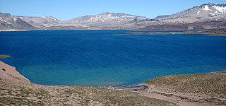
Laguna del Maule is a lake located in the Andes of Central Chile. The lake is natural in origin, but its water level was raised by a dam inaugurated in 1957. It is located at 2,165 metres above sea level. It has a capacity of 1,420 million m3.

<span class="mw-page-title-main">Bertrand Lake</span> Lake in Chile

Bertrand Lake is a Chilean lake located in the Aysén del General Carlos Ibáñez del Campo Region. It is separated from Plomo Lake by a terminal moraine and is flanked on the west by the summits of the Cordón Contreras.

<span class="mw-page-title-main">Lanalhue Lake</span> Fault lake in Chile

Lanalhue Lake is a Chilean lake located in the Arauco Province of Bío Bío Region. The lake is placed in the Nahuelbuta Range above the Lanalhue Fault.

<span class="mw-page-title-main">Lleulleu Lake</span>

Lleulleu Lake is a Chilean lake located in the Bío Bío Region.

<span class="mw-page-title-main">Cerrón Grande Dam</span> Dam in Chalatenango

The Cerrón Grande Hydroelectric Dam spans the Lempa River 78 km (48 mi) north of San Salvador in the municipalities of Potonico, (Chalatenango) and Jutiapa (Cabañas) in El Salvador.

The Acomé River is a river in Guatemala. It is a short coastal river in the southwest of the country, with a length of 58.5 kilometres (36.4 mi). It begins in the vicinity of the town of Santa Lucia Cotzumalguapa, in the Escuintla Department, and runs southward, crossing the coastal plain of Escuintla to empty into the Pacific Ocean. The Acomé watershed has a population of about 53,510 people.

The Blanco River is a river of Guatemala. It is located in the department of San Marcos. The Blanco joins the Cuilco River through its tributary the Las Manzanas River.

<span class="mw-page-title-main">Instituto Nacional de Sismología, Vulcanología, Meteorología e Hidrología</span> Scientific agency of the Guatemalan government

The National Institute for Seismology, Vulcanology, Meteorology and Hydrology of Guatemala is a scientific agency of the Guatemalan government. The agency was created to study and monitor atmospheric, geophysical and hydrological phenomena and events, their hazards to Guatemalan society, and to provide recommendations to the government and the private sector in the occurrence of natural disasters. The agency has four major scientific disciplines, concerning Seismology, Vulcanology, Meteorology and Hydrology.

<span class="mw-page-title-main">Volcán Siete Orejas</span>

Volcán Siete Orejas is a stratovolcano in Guatemala located within the Quetzaltenango Department, in the municipalities of Quetzaltenango, Concepción Chiquirichapa, La Esperanza, and San Martin Sacatepequez. It is in the Sierra Madre de Chiapas.

<span class="mw-page-title-main">Lagunas de Montebello National Park</span> National park in Chiapas, Mexico

Lagunas de Montebello, or Montebello Lakes, is a national park in the Mexican state of Chiapas, near the border with Guatemala, comprising 59 multi-colored lakes in a pine forest and two Maya ruins. It was the first national park in Chiapas when created in 1959, and in 2009 the park was designated a Biosphere Reserve by UNESCO.

<span class="mw-page-title-main">Baldhill Dam</span> Dam in Barnes County, North Dakota

Baldhill Dam is a dam in Barnes County, North Dakota, about 10 miles north-northwest of Valley City in the eastern part of the state.

<span class="mw-page-title-main">Abiquiu Dam</span> Dam in Rio Arriba County, New Mexico

Abiquiu Dam is a dam on the Rio Chama, located about 60 miles (97 km) northwest of Santa Fe in Rio Arriba County, New Mexico, USA. Built and operated by the U.S. Army Corps of Engineers (USACE), the dam is an earth embankment structure 354 feet (108 m) high and 1,800 feet (550 m) long, containing 11.8 million cubic yards of fill. The dam forms Abiquiu Lake, one of the largest lakes in New Mexico, with a full storage capacity of 1,369,000 acre-feet (1,689,000 dam3) and 5,200 acres (2,100 ha) of water. To date, the reservoir has never filled to capacity, with a record high of 402,258 acre-feet (496,178 dam3), 29.4% of full pool, on June 22, 1987. The dam's primary purpose is flood control, in addition to irrigation and municipal water storage, and hydroelectric generation.

References