
This is a list of active, dormant, and extinct volcanoes in Guatemala. [1]
This is a list of active, dormant, and extinct volcanoes in Guatemala. [1]

Volcán Atitlán is a large, conical, active stratovolcano adjacent to the caldera of Lake Atitlán in the Guatemalan Highlands of the Sierra Madre de Chiapas range. It is within the Sololá Department, in southwestern Guatemala.

Lake Atitlán is a lake in the Guatemalan Highlands of the Sierra Madre mountain range. The lake is located in the Sololá Department of southwestern Guatemala. It is known as the deepest lake in Central America.

Tolimán is a stratovolcano in Guatemala, on the southern shores of Lake Atitlán. Part of the Sierra Madre mountain range, the volcano has an elevation of 3,158 m and was formed near the southern margin of the Pleistocene Atitlán III caldera. The top of the volcano has a shallow crater and its flanks are covered with the thick remains of ancient lava flows that emerged from vents in the volcano's flanks.

Volcán San Pedro is a 3,020-metre (9,908 ft) stratovolcano on the shores of Lago de Atitlán, in the Sololá Department of southern Guatemala. It is part of the mountain range of the Sierra Madre.

The Almolonga volcano, also called "Cerro Quemado" or "La Muela" due to its distinct shape, is an andesitic stratovolcano in the south-western department of Quetzaltenango in Guatemala. Part of the mountain range of the Sierra Madre, the volcano is located near the town of Almolonga, just south of Quetzaltenango, Guatemala's second largest city.

Laguna de Ayarza is a crater lake in Guatemala. The lake is a caldera that was created some 20,000 years ago by a catastrophic eruption that destroyed a twinned volcano and blanketed the entire region with a layer of pumice. The lake has a surface area of 14 km² and a maximum depth of 230 m. The lake has a surface elevation of 1409 m.

Volcán Siete Orejas is a stratovolcano in Guatemala located within the Quetzaltenango Department, in the municipalities of Quetzaltenango, Concepción Chiquirichapa, La Esperanza, and San Martin Sacatepequez. It is in the Sierra Madre de Chiapas.

The Cuilapa-Barbarena volcanic field is a field of cinder cones in Guatemala with approximately 70 cones. At an elevation of 1,454 m, the field is located over the intersection of the local Jalpatagua fault with the Miocene Santa Rosa de Lima caldera. The youngest cones postdate the last activity phase of Tecuamburro and may be of Holocene age, but with no confirmed evidence.
| Guatemala | 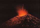 | |
|---|---|---|
| El Salvador | ||
| Nicaragua | ||
| Costa Rica | ||
| Panama | ||
Note: volcanoes are ordered from north-west to south-east. | ||
