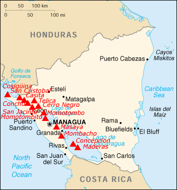
This is a list of active and extinct volcanoes in Nicaragua.
Contents
This is a list of active and extinct volcanoes in Nicaragua.

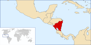
Nicaragua, officially the Republic of Nicaragua, is the largest country in the Central American isthmus, bordered by Honduras to the northwest, the Caribbean to the east, Costa Rica to the south, and the Pacific Ocean to the southwest. Managua is the country's capital and largest city. As of 2015, it was estimated to be the second largest city in Central America. The multi-ethnic population of six million includes people of mestizo, indigenous, European and African heritage. The main language is Spanish. Indigenous tribes on the Mosquito Coast speak their own languages and English.
Nicaragua is a country in Central America, bordering both the Caribbean Sea and the North Pacific Ocean, between Costa Rica and Honduras. Nicaragua is the largest country in Central America in square kilometers.

These lists cover volcanoes by type and by location.

Granada is a city in western Nicaragua and the capital of the Granada Department. With an estimated population of 104,980 (2021), it is Nicaragua's ninth most populous city. Granada is historically one of Nicaragua's most important cities, economically and politically. It has a rich colonial heritage, seen in its architecture and structure.

Concepción is one of two volcanoes that form the island of Ometepe, which is situated in Lake Nicaragua in Nicaragua, Central America.

With a height of 1,394 metres (4,573 ft), Maderas is the smaller of the two which make up the island of Ometepe, situated in Lake Nicaragua in Nicaragua, Central America. Unlike Concepción, the other volcano on the island, Maderas has not been active in historical times. Its crater contains a crater lake.

Masaya is a caldera located in Masaya, Nicaragua, 20 km south of the capital Managua. It is Nicaragua's first and largest national park, and one of 78 protected areas of Nicaragua. The complex volcano is composed of a nested set of calderas and craters, the largest of which is Las Sierras shield volcano and caldera. Within this caldera lies a sub-vent, which is Masaya Volcano sensu stricto. The vent is a shield type composing of basaltic lavas and tephras and includes a summit crater. This hosts Masaya caldera, formed 2,500 years ago by an 8-km³ basaltic ignimbrite eruption. Inside this caldera a new basaltic complex has grown from eruptions mainly on a semi-circular set of vents that include the Masaya and Nindiri cones. The latter host the pit craters of Masaya, Santiago, Nindiri and San Pedro. Observations in the walls of the pit craters indicate that there have been several episodes of cone and pit crater formation.
Mombacho is a stratovolcano in Nicaragua, near the city of Granada. It is 1,344 metres (4,409 ft) high. The Mombacho Volcano Nature Reserve is one of 78 protected areas of Nicaragua. Mombacho’s last eruption occurred in 1570. There is no historical knowledge of earlier eruptions.

Momotombo is a stratovolcano in Nicaragua, not far from the city of León. It stands on the shores of Lago de Managua. An eruption of the volcano in 1610 forced inhabitants of the Spanish city of León to relocate about 48 km (30 mi) west. The ruins of this city are preserved at León Viejo. It also erupted in 1886, 1905, and most recently November 30, 2015.

Volcán San Cristóbal is the highest volcano in Nicaragua at 1,745 m (5,725 ft). Near the northwest corner of the country, it forms a backdrop to the city of Chichigalpa, Chinandega. It is also among the most active volcanoes in Nicaragua.
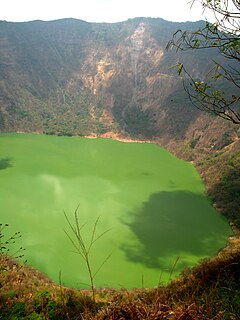
Cosigüina is a stratovolcano located in the western part of Nicaragua. It forms a large peninsula extending into the Gulf of Fonseca. The summit is truncated by a large caldera, 2 x 2.4 km in diameter and 500 m deep, holding a substantial crater lake. This cone has grown within an earlier caldera, forming a somma volcano. The earlier caldera rim is still exposed on the north side, but has been buried by the younger cone elsewhere.

Telica is a stratovolcano, one of several volcanoes of the Nicaraguan volcanic front. It is located in Telica municipality, in the León department of Nicaragua. One of Nicaragua's most active volcanoes, Telica has erupted frequently, and ash from those frequent eruptions keeps the slopes of its cone bare of vegetation.

Apoyeque is a pyroclastic shield, located in the Chiltepe Peninsula Natural Reserve in Nicaragua. It has a 2.8-km wide, 400-m-deep, lake-filled caldera.

Tourism in Nicaragua has grown considerably recently, and it is now the second largest industry in the nation. Nicaraguan President Daniel Ortega has stated his intention to use tourism to combat poverty throughout the country.

The protected areas of Nicaragua are areas that have natural beauty or significance and are protected by Nicaragua. Nicaragua has 78 protected areas that cover 22,422 km², about 17.3% of the nations landmass. The National System of Protected Areas (SINAP) is administered by the Ministry of the Environment and Natural Resources (MARENA).
The following is an alphabetical list of topics related to Nicaragua.

This is an Index of Central America-related articles. This index defines Central America as the seven nations of Belize, Costa Rica, El Salvador, Guatemala, Honduras, Nicaragua, and Panama.
| Guatemala | 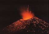 | |
|---|---|---|
| El Salvador | ||
| Nicaragua | ||
| Costa Rica | ||
| Panama | ||
Note: volcanoes are ordered from north-west to south-east. | ||