Transport in Nicaragua

Last updated

Transport in Nicaragua revolves around road, air and water transport modalities.

Contents

Road transport

The road infrastructure is very well spread across the Pacific side, while the Atlantic side has less infrastructure. As of 2009, from a total of 19,137 km 2,033 km are paved and 17,104 km are unpaved. [1]

Public transport

Public transport in Nicaragua is mostly served by buses on both short and wide range distances. There are five different types, based on the size of the vehicle, target group, frequency of stops and distance. [2]

Urban buses

Former school bus at Ferrecalle in Esteli used as urban bus on the line from Hospital to Oscar Gamez. Urban bus at Ferrecalle, Esteli.jpg
Former school bus at Ferrecalle in Estelí used as urban bus on the line from Hospital to Oscar Gamez.
Former school bus at Hospital in Esteli used as urban bus on the line from Hospital to Villa Cuba. Urban bus at Hospital, Esteli.jpg
Former school bus at Hospital in Estelí used as urban bus on the line from Hospital to Villa Cuba.

Urban buses (Urbanos) can be found in Managua, Estelí, León, Chinandega, Matagalpa and Bluefields. In most cases, passengers have to pay for each ride on a bus, with the need to pay again when switching to another. The costs differ from 2.50 C$ in Managua to 10 C$ in Bluefields. [2]

An urban bus in Nicaragua takes the same road multiple times per day, following a more or less strict schedule. The organization of the buses in different towns differs heavily as every town is organizing it on their own behalf. In Estelí every bus driver is assisted by mostly two persons helping them (Ayudantes). Bus drivers in Managua have to manage their job on their own. [2]

Another fact that heavily differs are the vehicles used in the different cities. In Managua mostly urban buses sponsored by Russia are used, in Estelí former school buses from the United States, in Bluefields Japanese light commercial vans and in León pickup trucks that got extended with seats and a roof. [2]

Bus stop sign in Esteli Bus stop sign in Esteli.jpg
Bus stop sign in Estelí

The quality of bus stops also heavily differs. In the center of Managua many proper bus stops exist with roofs or at least signs, in other areas there often isn't any indication of a bus stop. Nevertheless, buses serve a network of established stops with common names known by bus assistants. Passengers need to know or ask where and when which bus stops. [2]

To improve the accessibility of public transport, in 2016 the OpenStreetMap group in Nicaragua MapaNica crowdsourced with the help of more than 150 citizens of Managua the first bus transit map in whole Central America. [3] Later in 2018, they made this data machine-accessible, serving it today in different apps on several platforms. [4]

Urban buses in Managua will be use Brazilian dual-mode bus and hybrid electric bus that are currently in evaluation process.

Suburban buses

Suburban buses (Suburbanos) connect larger cities with communities in outer areas. They only stop a few times inside the city, later nearly everywhere where passengers request to get off. Like with urban buses, a team serves a route several times per day and the service is organized by the local government. Prices can vary depending on the distance. [2]

Ruteados

Ruteado at COTRAN Sur, Esteli Ruteado in COTRAN Sur, Esteli, Nicaragua.jpg
Ruteado at COTRAN Sur, Estelí

Connecting two or more cities, Ruteados (also called Servicio Ordinario) are the biggest part of bus services in Nicaragua. [2]

Express buses

Express bus in Nicaragua Express long-distance bus in Nicaragua.jpg
Express bus in Nicaragua

Express buses (Expresos) connect, like Ruteados and share taxis, two or more cities, but with less stops, resulting in a faster travel time. [2]

Share taxis

Share taxi at COTRAN Norte, Esteli Interlocal at COTRAN Norte, Esteli, Nicaragua.jpg
Share taxi at COTRAN Norte, Estelí

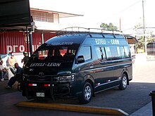
Share taxis are called Interlocales in Nicaragua and also connect two or more cities, like Ruteados and express buses, with the main difference that they depart from the bus station once they are filled either mostly or completely with passengers. Like express buses, they nearly don't stop between start and destination. [2]

Air transport

Several airports are serving both national and international flights.

Airports

As of 2013, 147 airports exist in Nicaragua. [1] Nicaragua's main international airport is Managua International Airport.

Airports - with paved runways

In total, there are 12 airports with paved runways with the following lengths: [1]

  • 2,438 to 3,047 m: 3
  • 1,524 to 2,437 m: 2
  • 914 to 1,523 m: 3
  • under 914 m: 4

Airports - with unpaved runways

In total, there are 135 airports with unpaved runways with the following lengths: [1]

  • 1,524 to 2,437 m: 1
  • 914 to 1,523 m: 15
  • under 914 m: 119

Water transport

Nicaragua offers 2,220 km of water transport roads, including the two large lakes Lake Nicaragua and Lake Managua. A Nicaragua Canal was planned but canceled on 21 February 2018. [5] [6] [7]

Ports and harbors

Atlantic Ocean (Caribbean)

Pacific Ocean

Other

Rail transport

Since September 2001, all rail transport has been suspended in Nicaragua.

Rapid transit

Managua will have metro system that is currently in the feasibility study conducted by Japan International Cooperation Agency.

Related Research Articles

<span class="mw-page-title-main">Transport in the Central African Republic</span>

Modes of transport in the Central African Republic include road, water, and air. Most of the country is connected to the road network, but not all of it. Some roads in the country do not connect to the rest of the national road network and may become impassable, especially during heavy monsoon rain. Many remote areas that not connected to the country's road network, especially in the eastern part of the country outside of the major cities and towns, can only be reached by light aircraft, boat or on foot. Most roads are unpaved, and which centres on the routes nationales identified as RN1 to RN11. Bangui serves as a seaport, and 900 km of inland waterways are navigable, the main route being the Oubangui river. There is one international airport at Bangui-Mpoko, two other paved airports, and over 40 with unpaved runways.

<span class="mw-page-title-main">Transport in the Czech Republic</span>

Transport in the Czech Republic relies on several main modes, including transport by road, rail, water and air.

<span class="mw-page-title-main">Transport in the Dominican Republic</span>

Transport in the Dominican Republic utilizes a system of roads, airports, ports, harbours, and an urban railway.

Transport in Egypt is centered in Cairo and largely follows the pattern of settlement along the Nile. The Ministry of Transportation and other government bodies are responsible for transportation in Egypt, whether by sea, river, land or air.

<span class="mw-page-title-main">Transport in El Salvador</span>

El Salvador has transport links by road, rail, sea and air.

Modes of transport in Fiji include rail, road, water, and air. The rail network is mainly used for movement of sugar cane. Suva and Lautoka are the largest seaports. There are 122 km of navigable inland waterways. There are two international airports, one other paved airport, and over 20 with unpaved runways. With 333 tropical islands that make up this country, one can expect to use various modes of transport to get to their destination.

Railways: 0 km

Railways: 0 km

<span class="mw-page-title-main">Transport in Greece</span>

Transport in Greece has undergone significant changes in the past two decades, vastly modernizing the country's infrastructure and transportation. Although ferry transport between islands remains the prominent method of transport between the nation's islands, improvements to the road infrastructure, rail, urban transport, and airports have all led to a vast improvement in transportation. These upgrades have played a key role in supporting Greece's economy, which in the past decade has come to rely heavily on the construction industry.

Transportation in Guatemala includes roads, waterways, airports and a short cross-border rail line from Mexico.

<span class="mw-page-title-main">Transport in Guinea-Bissau</span>

Transport infrastructure in Guinea-Bissau is basic, with most roads outside the capital Bissau being unpaved.

Transport in Hungary relies on several main modes, including transport by road, rail, air and water.

<span class="mw-page-title-main">Transportation in the Marshall Islands</span>

Railways: 0 km

This article describes the transport in Peru.

Most internal transport in Solomon Islands is conducted through boat travel between islands. Road transport infrastructure is rudimentary, with few paved roads.

<span class="mw-page-title-main">Transport in Vanuatu</span>

Vanuatu's undeveloped road system, with fewer than 100 miles of paved roads, consists mostly of dirt tracks suitable only for four-wheel-drive vehicles. Every island has one or two short airstrips where Vanair’s Twin Otter planes land two or three times weekly. In addition, every island has a small port or wharf where small cargo ships and boats regularly dock.

Transport in Crete has undergone significant changes in the past two decades, vastly modernizing the country's infrastructure. Although ferry transport between islands remains the prominent method of transport between the nations islands, improvements to the road infrastructure, rail, urban transport, and airports have all led to a vast improvement in transportation. These upgrades have played a key role in supporting Greece's economy, which in the past decade has come to rely heavily on the construction industry.

References

  1. 1 2 3 4 "Nicaragua - The World Factbook". Central Intelligence Agency. CIA.
  2. 1 2 3 4 5 6 7 8 9 Gütschow, Mikolai-Alexander (July 7, 2018). "Gestern und heute: Öffentlicher Verkehr in Nicaragua". Nico Alt. Retrieved July 11, 2018.
  3. Delattre, Felix (February 2, 2016). "The true geographers take the bus". Confidencial. Retrieved July 23, 2018. But two years ago, a group inhabitants of Managua by own initiative decided to take the feat and create the first bus network map in whole Central America. [...] This way more than 150 citizens collaborated in this gigantic task to map all routes and bus stops of the two cities. [...] The map is handed over today at 9am at one of the main and most central bus stops (UCA).
  4. "OpenStreetMap and the Buses in Nicaragua – Presentation in Casa Vínculos, Estelí". MapaNica. March 8, 2018. Retrieved July 23, 2018. Six months later, the two groups started working together to improve the dates and to bring the project to the next level which they presented in this talk: the first mobile application to navigate through the public transport in Managua, Estelí and some national routes.
  5. "Incertidumbres financieras desvanecen sueño de canal en Nicaragua". El Financiero. AFP. February 21, 2018. Retrieved February 21, 2018.
  6. Gautier, Charles (February 21, 2018). "Le projet de canal du Nicaragua prend l'eau". Le Figaro. Retrieved February 21, 2018.
  7. Cropsey, Seth (April 9, 2018). "China Sets Its Sights on South America". The American Interest. Retrieved April 9, 2018. China has abandoned its attempts to construct a Nicaraguan Canal to compete with its Panamanian counterpart.