This article needs additional citations for verification .(December 2009) |
This article talks about transportation in the Bahamas , a North American archipelagic state in the Atlantic Ocean.
This article needs additional citations for verification .(December 2009) |
This article talks about transportation in the Bahamas , a North American archipelagic state in the Atlantic Ocean.
Approximately 2,718 kilometres (1,689 mi) of road in the Bahamas is classified as highway. Of these, approximately 1,560 kilometres (970 mi) are paved. Drivers drive on the left. Golf carts are common in certain low traffic residential communities, resorts, and shopping areas away from main roads.
The Sustainable Nassau Action Plan published a report in 2022 suggesting the number of new cars on New Providence over course of the 2010s outpaced population growth, and urged officials to take measures to move away from car dependency and car-oriented development, and decrease congestion. [1]
Privately operated licensed jitneys are the main mode of public transport and way to get around at a low cost, with rides ranging from $1 to 3. Bus stops typically contain a bench shaded by a yellow and white kiosk. Jitneys can be identified by the route and number displayed on the vehicle.
In 2017, the government launched a pilot programme to unify the different routes under one bus system among other improvements such as clearer signage and timetables. [2] [3]
In 2023, the Bahamas Unified Public Transportation Company (UPTC) and Bluestone Labs will roll out a unified ridesharing-style digital system. The new UPTC Jitney Pass, available through the Bluestone B-ID app, will cover over 40 routes, provide a routing system and live updates, and eventually phase out cash payments. [4] UPTC president Harrison Moxey stated in February 2023 that the dispatch centre was near completion. [5]
For those who do not own or rent a car, taxis with capped fares are available. Many hotels and resorts have their own shuttle services to the airport, beach (if they are not directly on a beach), and other destinations. [6]
Ferry and water taxi services are found throughout the Bahamas, particularly services that operate between New Providence and the Out Islands. Other ferries connect Downtown Nassau to Paradise Island; Great Abaco to its nearby cays; Acklins, Crooked Island and Long Cay; and South Bimini Airport to North Bimini's resort town. There are also water taxi services in the Exumas. [7]
Marinas and harbours are plentiful on The Bahamas islands, making aquatic travel an easy way to navigate between the islands group. Boat travel can be the only way to reach some of the smaller islands. Travelers entering the island will need to clear customs first, but boatsmen can enter any of the following ports of entry and harbours in The Bahamas:
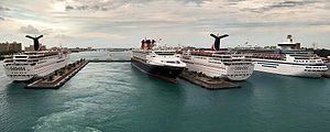
Facilities catering to large passenger cruise ships are located on Grand Bahama Island and New Providence. The Lucayan Harbour Cruise Facility in Freeport [8] and Nassau harbour's Prince George Wharf are built specifically to handle multiple modern cruise ships at one time.[ citation needed ] Additionally, several major cruise line corporations have each purchased an uninhabited island which they now operate as private island destinations available exclusively to their respective ships. These include Great Stirrup Cay, owned by Norwegian Cruise Line, Little Stirrup Cay otherwise known as Royal Caribbean International's "Coco Cay", Carnival Corporation's Little San Salvador Island or "Half Moon Cay", and Castaway Cay, of Disney Cruise Line. Of these, only Castaway Cay offers ships an actual pier for docking. The others use tender boats to service ships anchored off shore.
Total: 1,440 (2017 - CIA World Factbook) By type: bulk carrier 335, container ship 53, general cargo 98, oil tanker 284, other 670 (2017)
The Bahamas are one of the world's top five flag of convenience shipping registries.
The main airports on the islands are Lynden Pindling International Airport on New Providence, Grand Bahama International Airport on Grand Bahama Island, and Marsh Harbour International Airport on Abaco Island.[ citation needed ] Out of 62 airports in all, 23 have paved runways, of which there are two that are over 3,047 meters long.
Airports with paved runways:
Airports with unpaved runways:
Bahamasair is the national flag carrier airline of the Bahamas. [9]
A heliport is located on Paradise Island, [10] as well as other smaller islands, such as the various cruise line private islands.

There are no currently functioning railways in the Bahamas. However, there have been a few in the past including in Inagua, Abaco, and Grand Bahama used for the salt and logging industries.
At Wilson City, Abaco, a mill plant and adjacent town was developed by the Bahamas Timber Company and Owens Illinois at a cost of $1 million, including building 12 miles of railway for logging. [11] They operated three locomotives: a Vulcan 2-6-0, a Vulcan 0-4-4 tank, and a shay locomotive built at Lima Locomotive Works in Ohio. Only one train remains at Wilson City as a rusting hulk out on the beach. After Wilson City shut down at the end of World War I, Abaco was extensively logged by the Bahamas Cuban company until 1940, when they moved to Pineridge, Grand Bahama.
In Inagua, the Morton salt company used small Brookville diesel locomotives to pull trains of salt around the area. The locomotives were phased out eventually, but the tracks remained for a few more years before being removed due to contamination issued with the salt.
There have been a handful of smaller railways that operated without locomotives, built for the purpose of transporting salt, sisal, and agricultural produce. These existed in Little Abaco, Exuma, Inagua (Inagua tramways, 1860s), and New Providence.
One of these were in Cat Island; the remnants of a short section of (now underwater) track can still be seen from the shore. The railroad was built in the 19th century to carry produce from Old Bight to a port where crops would be shipped to Europe and the US, and was closed when the US stopped foreign exports and plantations were no longer in use. The tracks were subsequently sent to the UK to be repurposed into scrap metal for weapons during World War II. [12]

The Bahamas, officially the Commonwealth of The Bahamas, is an island country within the Lucayan Archipelago of the West Indies in the Atlantic Ocean. It contains 97% of the Lucayan Archipelago's land area and 88% of its population. The archipelagic state consists of more than 3,000 islands, cays, and islets in the Atlantic Ocean, and is located north of Cuba and northwest of the island of Hispaniola and the Turks and Caicos Islands, southeast of the U.S. state of Florida, and east of the Florida Keys. The capital is Nassau on the island of New Providence. The Royal Bahamas Defence Force describes The Bahamas' territory as encompassing 470,000 km2 (180,000 sq mi) of ocean space.
Nassau is the capital and largest city of The Bahamas. It is located on the island of New Providence, which had a population of 246,329 in 2010, or just over 70% of the entire population of The Bahamas. As of April 2023, the preliminary results of the 2022 census of the Bahamas reported a population of 296,522 for New Providence, 74.26% of the country's population. Nassau is commonly defined as a primate city, dwarfing all other towns in the country. It is the centre of commerce, education, law, administration, and media of the country.

The earliest arrival of people in the islands now known as The Bahamas was in the first millennium AD. The first inhabitants of the islands were the Lucayans, an Arawakan language-speaking Taino people, who arrived between about 500 and 800 AD from other islands of the Caribbean.

The Bahamas are a group of about 700 islands and cays in the western Atlantic Ocean, of which only between 30 and 40 are inhabited. The largest of the islands is Andros Island, located north of Cuba and 200 kilometres southeast of Florida. The Bimini islands are to its northwest. To the North is the island of Grand Bahama, home to the second-largest city in the country, Freeport. The island of Great Abaco is to its east. In the far south is the island of Great Inagua, the second-largest island in the country. Other notable islands include Eleuthera, Cat Island, San Salvador Island, Acklins, Crooked Island, and Mayaguana. Nassau is the capital and largest city, located on New Providence. The islands have a tropical savannah climate, moderated by the Gulf Stream. The total size is 13,878 km2 (5,358 sq mi). Due to the many widespread islands it has the 41st largest Exclusive Economic Zone of 654,715 km2 (252,787 sq mi).

New Providence is the most populous island in the Bahamas, containing more than 70% of the total population. It is the location of the national capital city of Nassau, whose boundaries are coincident with the island; it had a population of 246,329 at the 2010 Census; the latest estimate (2016) is 274,400.

The Abaco Islands lie in the northern Bahamas, located about 193 miles east of Miami, Florida. The main islands are Great Abaco and Little Abaco, which is located just west of the northern tip of Great Abaco. There are several smaller barrier cays, of which the northernmost are Walker's Cay and its sister island Grand Cay. To the south, the next inhabited islands are Spanish Cay and Green Turtle Cay, with its settlement of New Plymouth, Great Guana Cay, private Scotland Cay, Man-O-War Cay, and Elbow Cay, with its settlement of Hope Town. Southernmost are Tilloo Cay and Lubbers Quarters. Another of note off Abaco's western shore is Gorda Cay, now a Disney-owned island and a cruise ship stop renamed Castaway Cay. Also in the vicinity is Moore's Island. On the Big Island of Abaco is Marsh Harbour, the Abacos' commercial hub and the Bahamas' third largest city, plus the resort area of Treasure Cay. Both have airports. A few mainland settlements of significance are Coopers Town and Fox Town in the north and Cherokee and Sandy Point in the south. Administratively, the Abaco Islands constitute seven of the 31 Local Government Districts of the Bahamas: Grand Cay, North Abaco, Green Turtle Cay, Central Abaco, South Abaco, Moore's Island, and Hope Town.

Grand Bahama is the northernmost of the islands of the Bahamas, with the town of West End located 56 nautical miles east of Palm Beach, Florida. It is the third largest island in the Bahamas island chain of approximately 700 islands and 2,400 cays. The island is roughly 530 square miles (1,400 km2) in area and approximately 153 kilometres (95 mi) long west to east and 24 kilometres (15 mi) at its widest point north to south. Administratively, the island consists of the Freeport Bonded Area and the districts of East Grand Bahama and West Grand Bahama. Nearly half of the homes on the island were damaged or destroyed in early September 2019 by Hurricane Dorian.

Ragged Island is a 23 km2 (8.9 sq mi) island and district in the southern Bahamas. Ragged Island is part of the Jumentos Cays and Ragged Island Chain. The crescent-shaped chain measures over 180 km (110 mi) in length and includes cays known as Raccoon Cay, Hog Cay and Double-Breasted Cay. Island ownership is stated to have been granted to William George Lockhart some time in the 18th century. On 8 September 2017, Duncan Town took a direct hit from Hurricane Irma.
Treasure Cay, is a parcel of land connected to Great Abaco Island in the Bahamas. It has a population of 1,187 as of the 2010 Bahaman census.

The effects of Hurricane Wilma in The Bahamas were generally unexpected and primarily concentrated on the western portion of Grand Bahama. Hurricane Wilma developed on October 15, 2005 in the Caribbean, and after initially organizing slowly it explosively deepened to reach peak winds of 185 mph (298 km/h) and a record-low pressure of 882 mbar (hPa). It weakened and struck eastern Mexico as a Category 4 hurricane on the Saffir–Simpson scale, and accelerated northeastward to make landfall on southwestern Florida on October 24. After crossing the state, Wilma briefly restrengthened in the open Atlantic Ocean, moving north of The Bahamas before weakening and later becoming an extratropical cyclone.
Flamingo Air is a small airline in the Bahamas. Its base of operations is the Grand Bahama International Airport in Freeport. It also has offices in Marsh Harbour Abaco Airport, in Bimini International Airport, and in the Lynden Pindling International Airport, Nassau. It provides scheduled service to several islands, as well as Air Charter service to the Bahamas and south Florida. The airline is currently grounded after a number of incidents in recent years. The Bahamian authorities have said they will keep all the aircraft grounded until inspections of Flamingo Air's maintenance and investigation into their safety practices are completed.

The effects of Hurricane Andrew in the Bahamas included three direct fatalities and $250 million (1992 USD) in damage. Forming from a tropical wave on August 16, Andrew remained weak until rapidly intensifying on August 22, and late on August 23 it made its first landfall in The Bahamas on Eleuthera as a Category 5 hurricane with winds of 260 km/h (160 mph); early the next day Hurricane Andrew passed through the southern Berry Islands with winds of 240 km/h (150 mph). The hurricane later made a devastating landfall in southern Florida, and after striking southern Louisiana it dissipated over the eastern United States. Andrew was the first major hurricane to affect the nation since Hurricane Betsy in 1965. It caused $250 million in damage, with damage heaviest on Eleuthera and Cat Cay. Four deaths occurred due to the storm, of which one was indirectly related to the hurricane.
The following outline is provided as an overview of and topical guide to The Bahamas:
The Bahamas National Trust is a non-profit organisation in the Bahamas that manages the country's 32 national parks. Its headquarters is located in New Providence in the Bay Street Business Centre, East Bay Street. Its office was formally located at The Retreat Gardens on Village Road. The Bahamas National Trust was created by an Act of Parliament in 1959, through the efforts of two groups of conservationists.

The following is an alphabetical list of topics related to the Commonwealth of The Bahamas.

Long Island is an island in The Bahamas that is split by the Tropic of Cancer. It is one of the Districts of the Bahamas and is known as the most scenic island in the Bahamas. Its capital is Clarence Town. The population of Long Island is 3,094 inhabitants.

The effects of Hurricane Dorian in the Bahamas in 2019 were among the worst experienced for any natural disaster in the country. Hurricane Dorian struck the Abaco Islands as a Category 5 hurricane on September 1, and a day later hit Grand Bahama Island at the same category. The hurricane then stalled over Grand Bahama for another day, finally pulling away from the island on September 3. Damage amounted to US$3.4 billion, and there were at least 74 deaths in the country. Another 282 people were left missing after the hurricane.

The Bahama Archipelago, also known as the Lucayan Archipelago, is an island group comprising the Commonwealth of The Bahamas and the British Overseas Territory of the Turks and Caicos Islands. The archipelago is in the western North Atlantic Ocean, north of Cuba along with the other Antilles, and east and southeast of Florida. The archipelago has experienced the effects of at least 22 Atlantic hurricanes, or storms that were once tropical or subtropical cyclones, including 17 since 2000. The storms collectively killed 101 people.
