Transport in Suriname

Last updated
Primary road between Paramaribo and Brownsweg. Primary road between Paramaribo and Brownsweg.JPG
Primary road between Paramaribo and Brownsweg.

The Republic of Suriname (Dutch : Republiek Suriname) has a number of forms of transport. Transportation emissions are an increasing part of Suriname's contributions to climate change, as part of the Nationally Determined Contributions for the Paris Agreement, Suriname has committed to emissions controls for vehicles and increased public transit investment. [1]

Contents

Railways

Highways

Main roads in Suriname
.mw-parser-output .legend{page-break-inside:avoid;break-inside:avoid-column}.mw-parser-output .legend-color{display:inline-block;min-width:1.25em;height:1.25em;line-height:1.25;margin:1px 0;text-align:center;border:1px solid black;background-color:transparent;color:black}.mw-parser-output .legend-text{}
East-West Link
Southern East-West Link
Desire Delano Bouterse Highway
Afobakaweg
Road to Pokigron Suriname main roads.png
Main roads in Suriname
The Jules Wijdenbosch Bridge over the Suriname River near Paramaribo. Paramaribo, Jules Wijdenboschbrug.JPG
The Jules Wijdenbosch Bridge over the Suriname River near Paramaribo.
The Coppename Bridge over the Coppename River near Boskamp. Coppename River.jpg
The Coppename Bridge over the Coppename River near Boskamp.
Bailey bridge over the Coppename River near Bitagron. Bailey-Coppename River.jpg
Bailey bridge over the Coppename River near Bitagron.

Afobakaweg

The Afobakaweg is a paved 2-lane road connecting Paranam with Afobaka, the location of the Afobaka Dam. The road connects northwards to Paramaribo and the East-West Link. [5] The Afobakaweg has two major branches: One paved branch leads to Brokopondo, and another paved [6] branch leads to Pokigron via Brownsweg. [7] A further extension of the Pokigron branch to Brazil via Vier Gebroeders is as of May 2020 still in the planning phase. [8]

Desiré Delano Bouterse Highway

On 15 May 2020, the Desiré Delano Bouterse Highway opened, and is the first motorway of Suriname, providing a faster connection between Paramaribo and the Johan Adolf Pengel International Airport. [9] [10]

A major road is the 2-lane East-West Link connecting Albina to Nieuw Nickerie. The road was fully paved on 17 December 2009. [11] There is a Southern East-West Link connecting Paramaribo with Apoera via Bitagron, however it is mainly unpaved. [12]

Statistics

NOTE: Driving is on the left. [15] Suriname and its neighbour Guyana are the only two countries on the (in-land) American continent which still drive on the left.

Waterways

1,200 km; most important means of transport; oceangoing vessels with drafts ranging up to 7 m can navigate many of the principal waterways. [2]

Ports and harbours

Merchant marine

Airports

Paved runways

Unpaved runways

See also

Related Research Articles

After the creation of the Statute of the Kingdom of the Netherlands, the Royal Netherlands Army was entrusted with the defence of Suriname, while the defence of the Netherlands Antilles was the responsibility of the Royal Netherlands Navy. The army set up a separate Netherlands Armed Forces in Suriname. Upon independence in 1975, this force was turned into the Surinamese Armed Forces. On February 25, 1980, a group of 15 non-commissioned officers and one junior officer, under the leadership of sergeant major Dési Bouterse, staged a coup d'état and overthrew the Government. Subsequently, the SKM was rebranded as the National Army.

Brokopondo District District of Suriname

Brokopondo is a district of Suriname. Its capital city is Brokopondo; other towns include Brownsweg and Kwakoegron.

Para District District of Suriname

Para is a district of northern Suriname. Para's capital city is Onverwacht, with other towns including Paranam, and Zanderij. Para has a population of 24,700 and an area of 5,393 km2. The district is the mining and forestry centre of Suriname, with many large bauxite mining operations operating. The district is a mixture of forest and savannas.

Sipaliwini District District of Suriname

Sipaliwini is the largest district of Suriname, located in the south. Sipaliwini is the only district that does not have a regional capital, as it is directly administered by the national government in Paramaribo.

Nieuw Nickerie Resort and City in Nickerie, Suriname

Nieuw Nickerie is the third largest city in Suriname with a population estimated at 12,818. It is the capital city of the Nickerie district, and the terminus of the East-West Link.

Brokopondo is the capital town of the Brokopondo District, Suriname. It is located on the west shore of the Suriname river, just north of the Afobaka dam. Brokopondo can be reached via the Afobakaweg from Paranam to Afobaka.

Suriname River

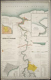
The Suriname River is 480 km long and flows through the country Suriname. Its sources are located in the Guiana Highlands on the border between the Wilhelmina Mountains and the Eilerts de Haan Mountains. The river flows below the reservoir along Brokopondo, Berg en Dal, the migrant communities Klaaskreek and Nieuw-Lombé, Jodensavanne, Carolina, Ornamibo and Domburg, before reaching the capital Paramaribo on the left bank and Meerzorg on the right bank. At Nieuw-Amsterdam it is joined by the Commewijne and immediately thereafter at the sandspit Braamspunt it flows into the Atlantic Ocean.

Brownsweg Town and Resort in Brokopondo, Suriname

Brownsweg is a town and resort in Suriname in the Brokopondo District. Its population at the 2012 census was 4,793.

Pokigron Place in Sipaliwini, Suriname

Pokigron is a town in Suriname located on Brokopondo Reservoir. It is located in the Boven Suriname municipality (resort) in the Sipaliwini District. It has a population of approximately 400 people in 2018. Pokigron is located at the end of a paved road via Brownsweg to the Afobakaweg. Pokigron is often referred to as Atjoni which is the nearby quay, and literally the end of the road. Villages to the South of Pokigron have to be accessed by boat. The village is home to Maroons of the Saramaka tribe.

Centrum, Brokopondo Resort in Brokopondo District, Suriname

Centrum is a resort in Suriname, located in the Brokopondo District. Its population at the 2012 census was 4,482. Centrum can be reached by car via the Afobakaweg from Paranam to Afobaka, or by boat via the Suriname River.

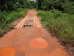
The (northern) East-West Link is a road in Suriname between Albina in the eastern part of the country to Nieuw Nickerie in the western part, via the capital city of Paramaribo. The southern East-West Link connects Paramaribo with Apoera via Bitagron. Construction of the road link started in the 1960s.

Jules Sedney Surinamese politician

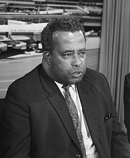
Jules Sedney was a Surinamese politician, and Prime Minister of Suriname from 20 November 1969 to 24 December 1973. In 1980, he became governor of the Central Bank of Suriname, but had to flee the country in 1983 after a dispute with Dési Bouterse. Sedney returned to Suriname in 1989.

Poesoegroenoe or Pusugrunu or Psugrunu is a Matawai village in Boven Saramacca, Sipaliwini District, central Suriname. The village lies along the Saramacca River and is the residence of the gaanman of the Matawai maroons.

Desiré Delano Bouterse Highway

The Desiré Delano Bouterse Highway is the first motorway in Suriname between Afobakaweg connecting Paramaribo and Brokopondo to the John F. Kennedyweg near Johan Adolf Pengel International Airport. The motorway opened on 15 May 2020 12:00.

Jaw Jaw, also Yaw Yaw, is a village of Saamaka Maroons in the Boven Suriname resort of the Sipaliwini District of Suriname. The village is located on the Suriname River.

Jules Sedney Harbour Harbour in Paramaribo, Suriname

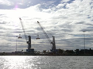
Jules Sedney Harbour is the main seaport for cargo ships in Paramaribo, Suriname. Until 2016, the harbour was called Nieuwe Haven. It is one of the two main cargo ports of Suriname. The other being Nieuw-Nickerie. Paramaribo used to have a generic harbour at Waterkant. In 1965, Nieuwe Haven opened as a specialised cargo harbour.

Nieuw-Lombe is a village in the resort of Klaaskreek in the Brokopondo District of Suriname. The village is located on the Suriname River, and is inhabitated by Saramaka maroons. Nieuw-Lombe is a transmigration village built for the inhabitants of Lombé which was flooded by the Brokopondo Reservoir after the construction of the Afobaka Dam.

Nieuw-Koffiekamp is a village in the resort of Brownsweg in the Brokopondo District of Suriname. It is a transmigration village built for the inhabitants of Koffiekamp which was flooded by the Brokopondo Reservoir after the construction of the Afobaka Dam.

References

  1. "Suriname's climate promise, for a sustainable future". UN News. 2020-01-31. Retrieved 2020-06-07.
  2. 1 2 3 "Suriname Transport". Nation Master. Retrieved 13 May 2020.
  3. "De Vraagbaak. Almanak voor Suriname 1913". Digital Library for Dutch Literature (in Dutch). 1912. Retrieved 13 May 2020.
  4. "Suriname railway plan announced". Railway Gazette International . 7 November 2014. Retrieved 13 May 2020..
  5. "REGIONAAL PLAN BROKOPONDO" (PDF). Planning Office Suriname (in Dutch). Retrieved 13 May 2020.
  6. "Suriname ontvangt geld van China om financiering project". Indian Feelings (in Dutch). Retrieved 14 May 2020.
  7. "District Brokopondo". Suriname.nu. Retrieved 13 May 2020.
  8. "Een weg komt nooit alleen" (PDF). University of Amsterdam (in Dutch). Retrieved 13 May 2020.
  9. "OFFICIELE OPENING HIGHWAY ZANDERIJ-AFOBAKAWEG OP 15 MEI". United News.sr (in Dutch). Retrieved 12 May 2020.
  10. "Ingebruikname Nieuwe Highway straks een feit". De Boodschap.today. Retrieved 15 May 2020.
  11. "Weg South Drain na 29 maanden klaar". De Ware Tijd via Nickerie.net (in Dutch). Retrieved 13 May 2020.
  12. "De natuurlijke omgeving van de zuidelijke Oost-west verbinding". Planning Office Suriname (in Dutch). Retrieved 13 May 2020.
  13. 1 2 3 "CIA Factbook 2003". Central Intelligence Agency". Retrieved 13 May 2020.
  14. "Werkzaamheden nieuwe Highway vorderen". De Boodschap (Official Press Office of the Government of Suriname) (in Dutch). Retrieved 12 May 2020.
  15. "Links of Rechts?". De West via Delpher (in Dutch). 4 January 1910. Retrieved 13 May 2020.
  16. 1 2 "Transport". Ministry of Transport, Communication and Tourism (in Dutch). Retrieved 4 May 2020.
  17. "Dr. Jules Sedney Terminal". Havenbeheer (in Dutch). Retrieved 12 May 2021.
  18. "DE GESCHIEDENIS VAN MEERZORG, ZOALS BESCHREVEN IN OUDE KRANTENBERICHTEN, DEEL 1 (1915-1940)". Plantage Justlust (in Dutch). Retrieved 12 May 2021.
  19. "Suriname Merchant Marine". Index Mundi. Retrieved 13 May 2020.
  20. "Suriname Airports with paved runways". Index Mundi. Retrieved 13 May 2020.
  21. "Suriname Airports - with unpaved runways". Index Mundi. Retrieved 13 May 2020.

Commons-logo.svg Media related to Transport in Suriname at Wikimedia Commons