
Suriname, officially the Republic of Suriname, is a country in northern South America, sometimes considered part of the Caribbean and the West Indies. Situated slightly north of the equator, over 90% of its territory is covered by rainforests, the highest proportion of forest cover in the world. Suriname is bordered by the Atlantic Ocean to the north, French Guiana to the east, Guyana to the west, and Brazil to the south. It is the smallest country in South America by both population and territory, with around 612,985 inhabitants in an area of approximately 163,820 square kilometers. The capital and largest city is Paramaribo, which is home to roughly half the population.

Sipaliwini is the largest district of Suriname, located in the south. Sipaliwini is the only district that does not have a regional capital, as it is directly administered by the national government in Paramaribo. Sipaliwini District includes disputed areas, with the southwestern region controlled and administered by Guyana, whereas the southeastern region is controlled by French Guiana.

The Guianas, also spelled Guyanas or Guayanas, is a region in north-eastern South America. Strictly, the term refers to the three Guyanas: Guyana, Suriname and French Guiana, formerly British, Dutch and French Guyana. Broadly it refers to the South American coast from the mouth of the Oronoco to the mouth of the Amazon.

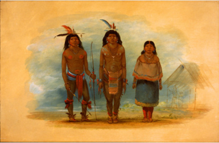
The Tiriyó are an Amerindian ethnic group native to parts of northern Brazil, Suriname, and Guyana. In 2014, there were approximately 3,640 Tiriyó in the three countries. They live in several major villages and a number of minor villages in the border zone between Brazil and Suriname. They speak the Tiriyó language, a member of the Cariban language family and refer to themselves as tarëno, etymologically 'people from here' or 'local people'.
The Courantyne River is a river in northern South America in Suriname and Guyana. It is the longest river in the country and creates the border between Suriname and the East Berbice-Corentyne region of Guyana.
Sipaliwini Savanna, also called Sipaliwini, is a Tiriyó village on the Sipaliwini River in the Sipaliwini District of Suriname. The village lies next to the Sipaliwini Airstrip. The nearest village in Suriname is Alalapadu which is located 60 kilometres north on a map, but due to the twists and turns of the river, the town of Kwamalasamutu which lies 83 kilometres west is easier to reach. The Brazilian village of Missão can be reached by an unpaved path.

Tapanahoni is a resort in Suriname, located in the Sipaliwini District. Its population at the 2012 census was 13,808. Tapanahoni is a part of Sipaliwini which has no capital, but is directly governed from Paramaribo. Tapanahony is an enormous resort which encompasses a quarter of the country of Suriname. The most important town is Diitabiki which is the residence of the granman of the Ndyuka people since 1950, and the location of the oracle.
Kwamalasamutu, also Kwamalasamoetoe, is a Tiriyó Amerindian village in the Sipaliwini District of Suriname, and home to the granman of the northern Trios. Kwamalasamutu is the biggest village of the Tiriyó tribe and is located near the disputed border with Guyana.
Kawemhakan, formerly also known as Anapaikë, is a Wayana village in the Sipaliwini District of Suriname. The village lies on the banks of the Lawa River, which forms the border with French Guiana.

Apetina, also known as Pïlëuwimë or Puleowime, is a village in the South Eastern jungle area of Suriname within the Tapanahony resort in the Sipaliwini District. It is located at 3°30′N55°04′W in the jungle on the small hills along the river Tapanahoni. Nearby points include Tebu Mountain, at around 347 m (1,138 ft) in height, and the Man Gandafutu waterfall. The majority of Apetina's population is the Wayana people. These Indians mostly originate from Brazil and once have fled because of tribal warfare. There also is primary school and an airstrip located near the Indian village of Apetina.
The Aparai or Apalai are an indigenous people of Brazil, who live in Amapá and Pará states. A little community is located in French Guiana, in Antecume Pata. They were sedentary slash-and-burn farmers, necessitating periodic relocation as soil became exhausted, but also hunters and gatherers. They spoke a Carib language and in the 20th century their subsistence shifted towards craftwork as they adapted to modern Brazil and the cash economy.

As of 2017, South America has an estimated population of 418.76 million people.
Kwamelasemoetoe Airstrip is an airport serving Kwamelasemoetoe, Suriname, a Trio Indian village in the south of Suriname in the Sipaliwini District. The name of the village means bamboo sand, named after nearby Sipaliwini River banks partly overgrown with bamboo.

Coeroeni is a resort in Suriname, located in the Sipaliwini District. Its population at the 2012 census was 1,046. The resort is mainly inhabited by indigenous people of the Tiriyó tribe. Kwamalasamutu is the main village of the resort and home to the granman Asongo Alalaparu.

The Tigri Area is a wooded area that has been disputed by Guyana and Suriname since around 1840. It involves the area between the Upper Corentyne River, the Coeroeni River, and the Kutari River. This triangular area is known as the New River Triangle in Guyana. In 1969 the conflict ran high on, and since then it has been controlled by Guyana and claimed by Suriname. In 1971, both governments agreed that they would continue talks over the border issue and withdraw their military forces from the disputed triangle. Guyana has never held upon this agreement.

Indigenous peoples in Guyana, Native Guyanese or Amerindian Guyanese are Guyanese people who are of indigenous ancestry. They comprise approximately 9.16% of Guyana's population. Amerindians are credited with the invention of the canoe, as well as Cassava-based dishes and Guyanese pepperpot, the national dish of Guyana. Amerindian languages have also been incorporated in the lexicon of Guyanese Creole.
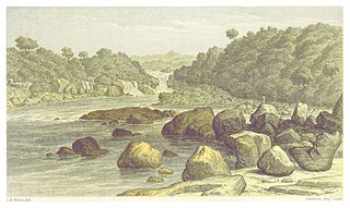
Amatopo or Amotopo is a Tiriyó village on the Courentyne River in the Sipaliwini District of Suriname. The village lies next to the Amatopo Airstrip and about 7 kilometres (4.3 mi) upstream from the village of Lucie. The Frederik Willem IV Falls and Arapahu Island are located near the village.
Kuruni is a village in the Coeroeni resort in the Sipaliwini District of Suriname. The village is inhabited by indigenous people of the Tiriyó tribe. The inhabitants are of the subgroup Aramayana or the Bee people.
The Taruma are an indigenous people found in the northern Brazil, southern Guyana, and southern Suriname. They used to speak Taruma which is considered critically endangered. The Taruma in Suriname have merged with the Tiriyó, in Brazil they merged with the Wai-wai. The Wapishana village of Maruranau in Guyana still recognises the tribe.

The Brazil–Suriname border is the international border between Brazil and Suriname and has a length of 593 km (368 mi). It is the shortest international border that Brazil has with its neighbors. The Surinamese side of the border is made up entirely of Sipaliwini, the largest district in the country. The Brazilian side of the border is almost entirely contained by Pará, with only 52 km of the border in the east with Amapá.


