Wayne is a county in the Commonwealth of Pennsylvania. It is part of Northeastern Pennsylvania. The county's population was 51,155 at the 2020 census. The county seat is the Borough of Honesdale. The county was formed from part of Northampton County on March 21, 1798, and was named for the Revolutionary War General Anthony Wayne.

Chesterbrook is a census-designated place (CDP) in Chester County, Pennsylvania, United States. It is located within the Philadelphia metropolitan area and just south of Valley Forge National Historical Park. The population was 4,589 at the 2010 census.

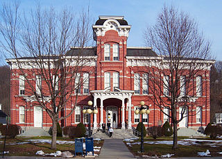
Smethport is a borough and county seat of McKean County, Pennsylvania, United States. The mayor is Wayne V. Foltz. The population was 1,430 at the 2020 census. Smethport is part of the Bradford, PA Micropolitan Statistical Area. Smethport, having the coldest temperature ever recorded in Pennsylvania, is the coldest place in Pennsylvania and one of the coldest towns in the contiguous United States.
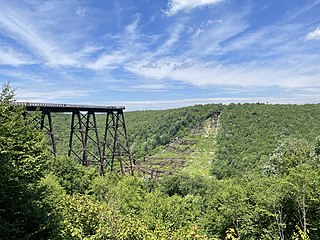
Kinzua Bridge State Park is a 339-acre (137 ha) Pennsylvania state park near Mount Jewett, in Hamlin and Keating Townships, McKean County, Pennsylvania in the United States. The park lies between U.S. Route 6 and Pennsylvania Route 59, along State Route 3011 just east of the Allegheny National Forest.

Lake Ariel is a village in Lake and Salem Townships of Wayne County, Pennsylvania, United States.

New York State Route 19 (NY 19) is a north–south state highway in Western New York in the United States. It is the longest state highway in that region, and the only other one besides NY 14 to completely transect the state from the Pennsylvania state line to the shore of Lake Ontario. It continues south into Pennsylvania as Pennsylvania Route 449 (PA 449) and ends at an intersection with the Lake Ontario State Parkway just south of the lakeshore in Hamlin. NY 19 does not serve any major cities or metropolitan areas and remains a two-lane rural road for almost its entire length. However, it follows the Genesee River for much of its lower length, and offers easy access to the gorges of Letchworth State Park midway along its route.

Tobyhanna State Park is a Pennsylvania state park on 5,440 acres (2,201 ha) mostly in Coolbaugh Township, Monroe County, with a small portion of the park in Dreher and Lehigh townships in Wayne County, all in Pennsylvania in the United States. The park includes the 170-acre (69 ha) Tobyhanna Lake and a portion of Tobyhanna Creek. It is located 2.1 miles (3.4 km) north of the town of Tobyhanna, with the main park entrance on Pennsylvania Route 423, and a portion that borders on Pennsylvania Route 196. The park lies immediately adjacent to Gouldsboro State Park, Pennsylvania State Game Lands 312, and State Game Land 127.

Varden Conservation Area is a Pennsylvania state park on 343 acres (139 ha) in Lake and South Canaan Townships, Wayne County, Pennsylvania in the United States. The conservation area is currently under development. The land was donated to the Commonwealth of Pennsylvania in December 2001 by Dr. Mead Shaffer a veterinarian and resident of Boothwyn, Pennsylvania in Delaware County. Dr. Shaffer stated his reason for donating the land, "Environmental education always has been a primary concern of mine. I trust this land will allow present and future generations to observe and study the diverse ecology found in the Varden Conservation Area." Varden Conservation Area is near the unincorporated village of Varden on Pennsylvania Route 296, east of the Lackawanna County line.
Prompton State Park is a Pennsylvania state park on 2,000 acres (809 ha) in Clinton and Dyberry Townships, Wayne County, Pennsylvania in the United States. This park, which was established in 1962, is officially listed by the Pennsylvania Department of Conservation and Natural Resources as being undeveloped. This means that it is officially a state park but the PA-DCNR is not currently managing the park. However, the lands of the park are open to visitors. Friends of Prompton State Park, a grassroots organization is working to take over management of the park in much the same way that Salt Springs State Park in Susquehanna County is managed by The Friends of Salt Springs Park. Northeast Sports Ltd. of Honesdale sponsors several outdoor sports events that are held at the park. Prompton State Park is 4.2 miles (6.8 km) west of Honesdale on Pennsylvania Route 170.

Lackawanna State Park is a 1,445-acre (585 ha) Pennsylvania state park in Benton and North Abington Townships, Lackawanna County, Pennsylvania in the United States. Lake Lackawanna, a 198-acre (80 ha) man-made lake, is the central focus of recreation at the park. Lackawanna State Park is located near Dalton on Pennsylvania Route 524 just off exit 199 of Interstate 81.

Pennsylvania Route 652 is a 10.559-mile-long (16.993 km) east–west state highway located in the northeast Pennsylvania county of Wayne. The western terminus of the route is at U.S. Route 6 in the Texas Township community of Indian Orchard. The highways heads to the northeast, and reaches the eastern terminus at the New York-Pennsylvania border in Damascus Township, where PA 652 crosses the Narrowsburg–Darbytown Bridge over the Delaware River and into New York, continuing as New York State Route 52 and County Route 24 in Sullivan County.

Pennsylvania Route 196 is a state highway in the Pocono Mountains of Pennsylvania with a length of 25.7 miles (41.4 km). It runs from PA 611 and PA 940 in Mount Pocono in Monroe County north to PA 296 in Varden in Wayne County. The route is a two-lane undivided road that runs through rural areas. PA 196 intersects PA 423 near Tobyhanna State Park before entering Wayne County, where it crosses PA 507 in Angels and passes through Sterling. The route forms a concurrency with PA 191 and has a junction with PA 590 in Hamlin. Upon splitting from PA 191, PA 196 continues north to its end at PA 296.

Pennsylvania Route 348 (PA 348) is a 7.21-mile-long (11.60 km) state highway located in Lackawanna and Wayne counties in Pennsylvania. The western terminus is at PA 435 near Elmhurst. The eastern terminus is at PA 590 near Hollisterville. PA 348 is a two-lane undivided road that runs through rural areas east of Scranton. From its beginning, the route runs a short distance to the north of Interstate 84 (I-84) before reaching an intersection with PA 247 in Mount Cobb. After this, PA 348 heads farther north from I-84 and leaves Lackawanna County for Wayne County, where it ends at PA 590.

Pennsylvania Route 590 is a 45.0-mile-long (72.4 km) state highway located in Lackawanna, Wayne, and Pike counties in Pennsylvania. The western terminus is at PA 435 in Elmhurst Township. The eastern terminus is at PA 434 in the community of Greeley in Lackawaxen Township. PA 590 is mostly a two-lane road that runs through rural areas in Northeastern Pennsylvania. The route serves the communities of Hamlin, Hawley, and Lackawaxen and passes to the north of Lake Wallenpaupack. PA 590 has intersections with PA 690 and PA 348 in Hollisterville, PA 191/PA 196 in Hamlin, and U.S. Route 6 in Hawley.

Pennsylvania Route 690 (PA 690) is a 12.53-mile-long (20.17 km) state highway located in Lackawanna and Wayne counties in Pennsylvania. The western terminus is at PA 502 in Spring Brook Township. The eastern terminus is at PA 590 in Salem Township. The route is a two-lane undivided road running through rural and some developed areas southeast of Scranton. From the western terminus, the route crosses PA 307 and has a partial interchange with Interstate 380 (I-380) before reaching Moscow, where it forms a brief concurrency with PA 435. From Moscow, PA 690 continues northeast to its terminus at PA 590 in Hollisterville. PA 690 was designated in 1928 between U.S. Route 611 in Moscow and PA 590 in Hollisterville. The route was extended west to PA 502 in the 1930s.
Lakeville is a village in Paupack Township, Wayne County, Pennsylvania, United States. It is located along the western shores of Lake Wallenpaupack and can be accessed by Pennsylvania Route 590, about eight miles east of Hamlin, and approximately seven miles west of Hawley, both on Route 590. The city of Scranton is located about 17 miles west.
Reedsville is an unincorporated community in Wayne Township in Schuylkill County, Pennsylvania, United States. Reedsville is located at the intersection of Pennsylvania Route 183 and Lutz Valley Road.

Blakeslee is an unincorporated community in Tobyhanna Township in Monroe County, Pennsylvania, United States. Blakeslee is located at the intersection of Pennsylvania Route 115 and Pennsylvania Route 940.
South Sterling is an unincorporated community in Dreher Township, Wayne County, Pennsylvania, United States. South Sterling is located along Pennsylvania Route 191 and the Wallenpaupack Creek, north of the intersection with Pennsylvania Route 423 and near the border with Pike County.
Lantz Corners is an unincorporated community in Hamlin Township in McKean County, Pennsylvania, United States. Lantz Corners is located at the intersection of U.S. Route 6 and U.S. Route 219 to the southwest of Mount Jewett.


